Showing Featured Lots(remove filter)
Filtered by Category:United States(Show All Categories)
Showing results for:Auction 168
Catalog Archive
23 lots
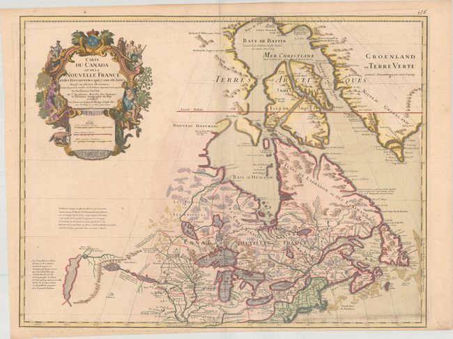
Auction 168, Lot 126
Subject: Colonial Northeastern United States & Canada, Great Lakes
Delisle, Guillaume
Carte du Canada ou de la Nouvelle France et des Decouvertes qui y ont ete faites…, 1718
Size: 25.5 x 19.7 inches (64.8 x 50 cm)
Estimate: $2,200 - $2,500
Delisle's Seminal Map of Canada and the Great Lakes
Sold for: $1,600
Closed on 6/6/2018
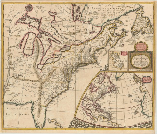
Auction 168, Lot 129
Subject: Colonial Eastern United States & Canada
Senex, John
A New Map of the English Empire in America viz Virginia New York Maryland New Iarsey Carolina New England Pennsylvania Newfoundland New France &c, 1719
Size: 23.6 x 19.9 inches (59.9 x 50.5 cm)
Estimate: $2,400 - $3,000
Important Map of the American Colonies
Sold for: $3,500
Closed on 6/6/2018
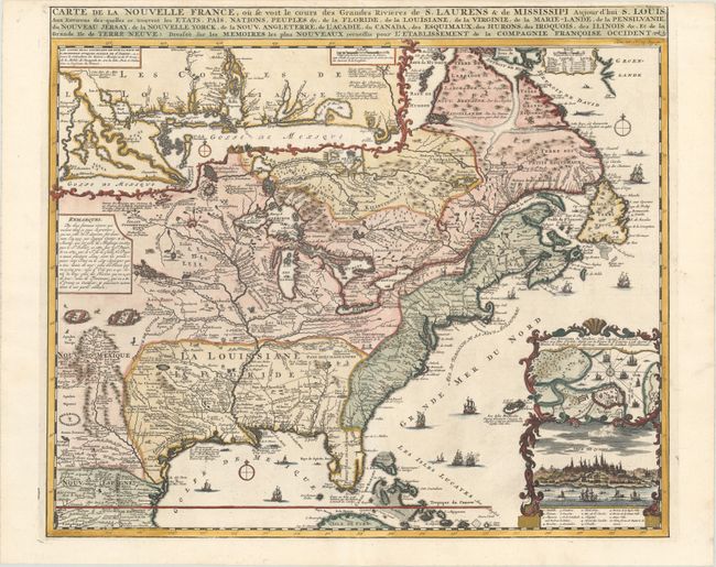
Auction 168, Lot 130
Subject: Colonial Eastern United States & Canada
Chatelain, Henry Abraham
Carte de la Nouvelle France, ou se Voit le Cours des Grandes Rivieres de S. Laurens & de Mississipi Aujour d'hui S. Louis, aux Environs des-quelles se Trouvent les Etats, Pais, Nations, Peuples &c..., 1720
Size: 19.4 x 16.6 inches (49.3 x 42.2 cm)
Estimate: $3,000 - $3,750
One of the Most Informative 18th Century Maps of the French Possessions in North America
Sold for: $2,200
Closed on 6/6/2018
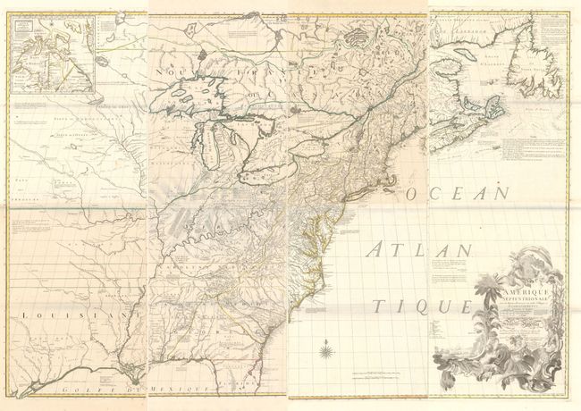
Auction 168, Lot 134
Subject: Colonial Eastern United States & Canada
Mitchell/Le Rouge
[On 8 Sheets] Amerique Septentrionale avec les Routes, Distances en Miles, Villages et Etablissements... / North America..., 1777
Size: 19 x 53 inches (48.3 x 134.6 cm)
Estimate: $10,000 - $13,000
Third French Edition of Mitchell's Monumental Map
Sold for: $7,500
Closed on 6/6/2018
Auction 168, Lot 135
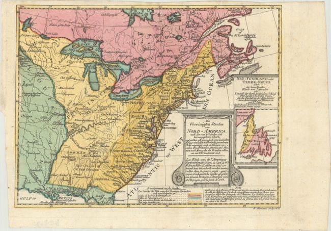
Subject: Colonial Eastern United States & Canada
Sotzmann, Daniel Friedrich
Die Vereinigten Staaten von Nord-America. Nach der von Wm. Faden 1783 herausgegebenen Charte / Les Etats Unis de l'Amerique Septentrionale d'Apres la Carte de Wm. Faden Publiee a Londres en 1783..., 1785
Size: 10 x 7.6 inches (25.4 x 19.3 cm)
Estimate: $600 - $800
Rare, Multi-Lingual Reduced Version of Faden's Map of 1783
Unsold
Closed on 6/6/2018
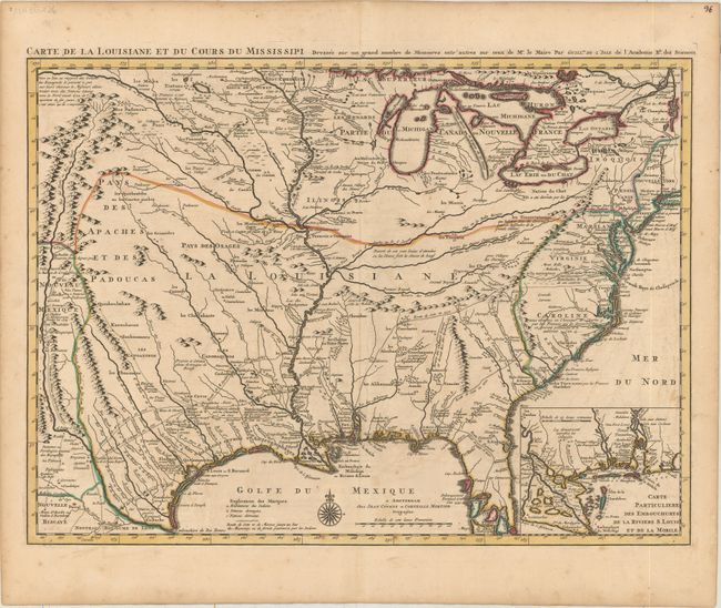
Auction 168, Lot 149
Subject: Colonial Eastern United States, Louisiana Territory
Delisle/Covens & Mortier
Carte de la Louisiane et du Cours du Mississipi Dressee sur un Grand Nombre de Memoires Entr'autres sur ceux de Mr. le Maire, 1733
Size: 23.5 x 17.2 inches (59.7 x 43.7 cm)
Estimate: $1,900 - $2,200
Delisle's Influential Map of the Louisiana Territory
Sold for: $1,400
Closed on 6/6/2018
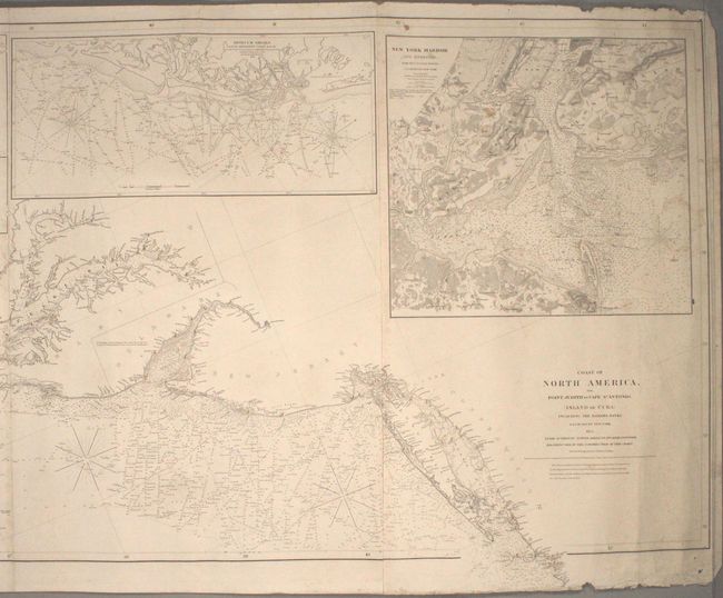
Auction 168, Lot 157
Subject: Eastern United States
Blunt, Edmund
Coast of North America, from Point Judith to Cape St. Antonio, (Island of Cuba) Including the Bahama Banks, 1853
Size: 132.7 x 30.7 inches (337.1 x 78 cm)
Estimate: $4,750 - $6,000
Impressive Blueback Chart of the Eastern Seaboard
Unsold
Closed on 6/6/2018
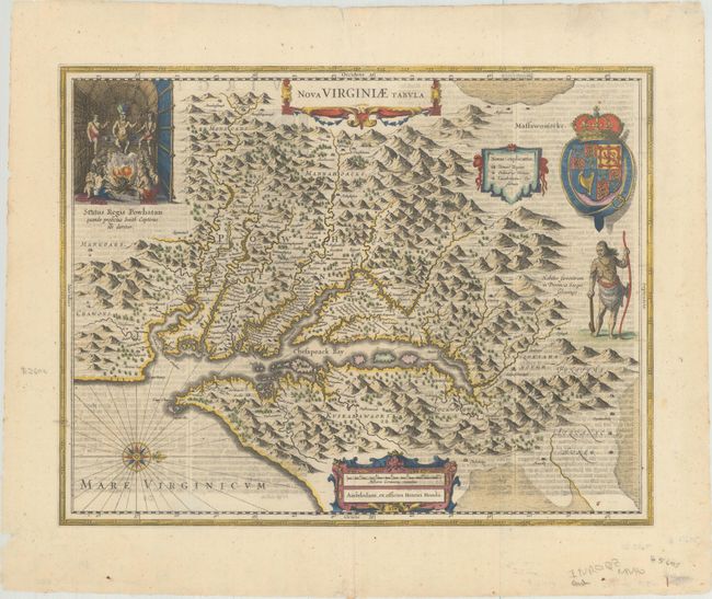
Auction 168, Lot 162
Subject: Colonial Mid-Atlantic United States
Hondius, Henricus
Nova Virginiae Tabula, 1645
Size: 19.6 x 15.1 inches (49.8 x 38.4 cm)
Estimate: $2,000 - $2,300
One of the Most Important 17th Century Maps of the Chesapeake Bay
Sold for: $1,200
Closed on 6/6/2018
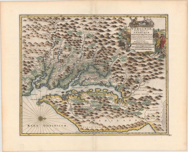
Auction 168, Lot 164
Subject: Colonial Mid-Atlantic United States
Aa, Pieter van der
Virginie, Grande Region de l'Amerique Septentrionale, avec tous Ses Bourgs, Hameaux, Rivieres et Bayes..., 1729
Size: 14.1 x 11.4 inches (35.8 x 29 cm)
Estimate: $1,600 - $1,900
Rare Derivative of John Smith's Map of the Chesapeake Bay
Sold for: $1,100
Closed on 6/6/2018
Auction 168, Lot 165
Subject: Colonial Mid-Atlantic United States
Homann, Johann Baptist
Virginia Marylandia et Carolina in America Septentrionali Britannorum Industria Excultae Repraesentatae, 1730
Size: 22.9 x 19.2 inches (58.2 x 48.8 cm)
Estimate: $1,600 - $2,000
Map Created to Promote German Immigration to the New World
Unsold
Closed on 6/6/2018
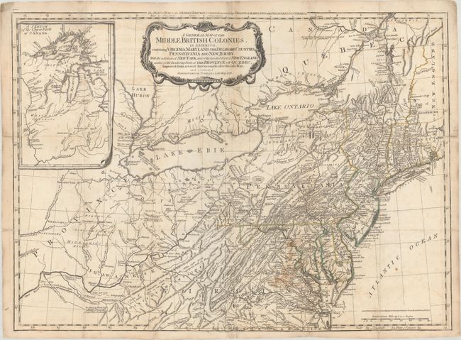
Auction 168, Lot 167
Subject: Colonial Mid-Atlantic United States
Sayer & Bennett
A General Map of the Middle British Colonies, in America. Containing Virginia, Maryland, the Delaware Counties, Pennsylvania and New Jersey. With the Addition of New York..., 1776
Size: 26.1 x 19.2 inches (66.3 x 48.8 cm)
Estimate: $4,000 - $4,750
Important British Map at the Outbreak of the American Revolution
Unsold
Closed on 6/6/2018
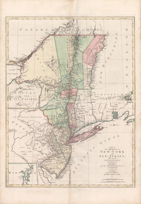
Auction 168, Lot 169
Subject: Colonial Mid-Atlantic United States
Lotter, Mathias Albrecht
[On 2 Sheets] A Map of the Provinces of New-York and New-Jersey, with a Part of Pennsylvania and the Province of Quebec. From the Topographical Observations of C.J. Sauthier, 1777
Size: 22.4 x 15 inches (56.9 x 38.1 cm)
Estimate: $2,200 - $2,500
Important Revolutionary War Map
Unsold
Closed on 6/6/2018
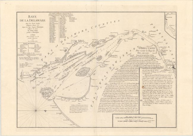
Auction 168, Lot 170
Subject: Colonial Mid-Atlantic United States, Delaware Bay
Le Rouge, George Louis
Baye de la Delaware avec les Ports, Sondes, Dangers, Bancs, &c. Depuis les Caps Jusqu'a Philadelphie..., 1777
Size: 25.1 x 18.4 inches (63.8 x 46.7 cm)
Estimate: $1,900 - $2,200
The Most Accurate Chart of Delaware Bay in the 18th Century
Unsold
Closed on 6/6/2018
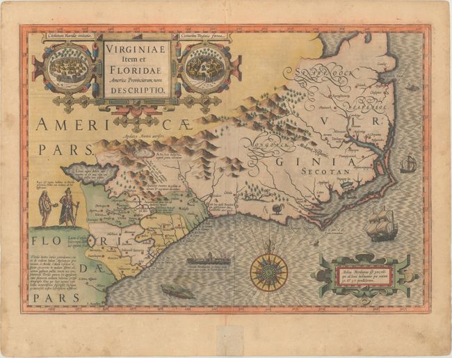
Auction 168, Lot 173
Subject: Colonial Southeastern United States
Hondius, Jodocus
Virginiae Item et Floridae Americae Provinciarum, Nova Descriptio, 1623
Size: 19.1 x 13.5 inches (48.5 x 34.3 cm)
Estimate: $1,900 - $2,300
A Seminal Map of the Southeast and Early American Cartography
Sold for: $1,400
Closed on 6/6/2018
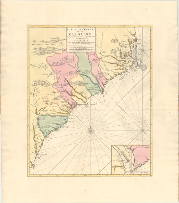
Auction 168, Lot 176
Subject: Colonial Southeastern United States
Covens & Mortier
Carte General de la Caroline. Dressee sur les Memoires le Plus Nouveaux par le Sieua S..., 1730
Size: 18.4 x 22.3 inches (46.7 x 56.6 cm)
Estimate: $2,750 - $3,500
The First Map of the Carolinas Published Outside of England
Sold for: $1,700
Closed on 6/6/2018
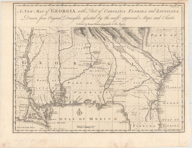
Auction 168, Lot 178
Subject: Colonial Southeastern United States
Bowen, Emanuel
A New Map of Georgia, with Part of Carolina, Florida and Louisiana. Drawn from Original Draughts, Assisted by the Most Approved Maps and Charts, 1748
Size: 18.8 x 14.3 inches (47.8 x 36.3 cm)
Estimate: $2,400 - $3,000
Important Map of the Georgia Colony
Sold for: $1,800
Closed on 6/6/2018
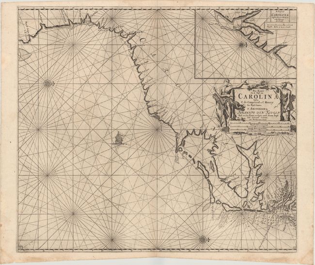
Auction 168, Lot 179
Subject: Colonial Southeastern United States
Keulen, Johannes van
Pas Kaart van de Kust van Carolina Tusschen C de Canaveral en C Henry, 1780
Size: 23 x 20.3 inches (58.4 x 51.6 cm)
Estimate: $1,800 - $2,200
Dutch Chart of the Carolinas
Sold for: $1,000
Closed on 6/6/2018
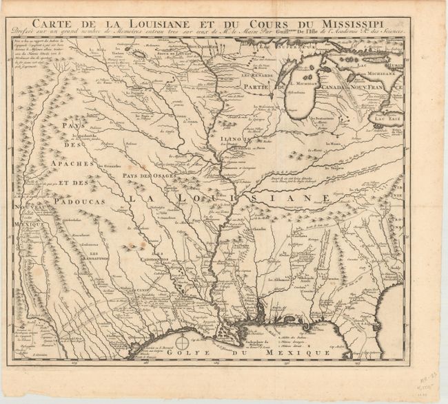
Auction 168, Lot 187
Subject: Colonial Central United States, Louisiana Territory
Delisle, Guillaume
Carte de la Louisiane et du Cours du Mississipi Dressee sur un Grand Nombre de Memoires Entrau Tres sur Ceux de Mr. le Maire, 1720
Size: 16.1 x 14 inches (40.9 x 35.6 cm)
Estimate: $1,100 - $1,400
Reduced-Size Edition of Delisle's Influential Map of the Louisiana Territory
Sold for: $1,000
Closed on 6/6/2018
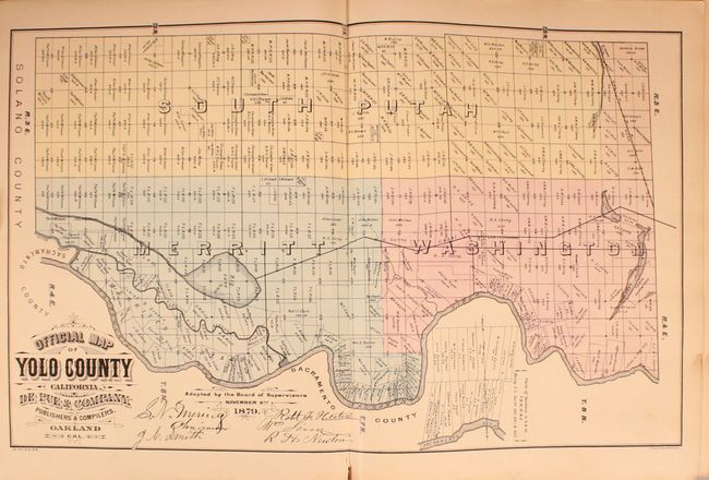
Auction 168, Lot 223
Subject: Northern California, Yolo County
The Illustrated Atlas and History of Yolo County, Cal. Containing a History of California from 1513 to 1850, A History of Yolo County from 1825 to 1880..., 1879
Size: 15 x 18.9 inches (38.1 x 48 cm)
Estimate: $2,000 - $2,500
A Fascinating Snapshot of the Sacramento Valley
Sold for: $1,500
Closed on 6/6/2018
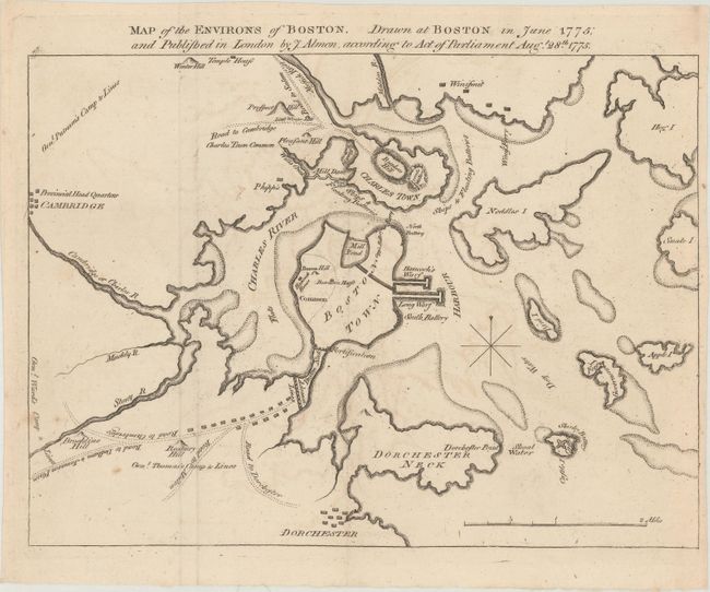
Auction 168, Lot 258
Subject: Boston, Massachusetts, Revolutionary War
Almon, John
Map of the Environs of Boston. Drawn at Boston in June 1775; and Published in London, 1775
Size: 10 x 7.4 inches (25.4 x 18.8 cm)
Estimate: $800 - $1,000
One of the Earliest Maps Relating to the American Revolution
Sold for: $650
Closed on 6/6/2018
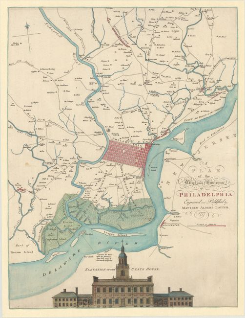
Auction 168, Lot 290
Subject: Philadelphia, Pennsylvania
Scull and Heap/Lotter
A Plan of the City and Environs of Philadelphia, 1777
Size: 17.8 x 23.2 inches (45.2 x 58.9 cm)
Estimate: $2,750 - $3,500
The "Most Famous Delineation of the Philadelphia Area in the Colonial Period"
Sold for: $1,700
Closed on 6/6/2018
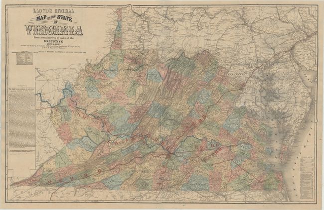
Auction 168, Lot 298
Subject: Virginia
Lloyd, James T.
Lloyd's Official Map of the State of Virginia From Actual Surveys by Order of the Executive 1828 & 1859..., 1862
Size: 47.3 x 30.4 inches (120.1 x 77.2 cm)
Estimate: $2,400 - $3,000
Extremely Rare Promotional Map with Railroad Overprint
Unsold
Closed on 6/6/2018
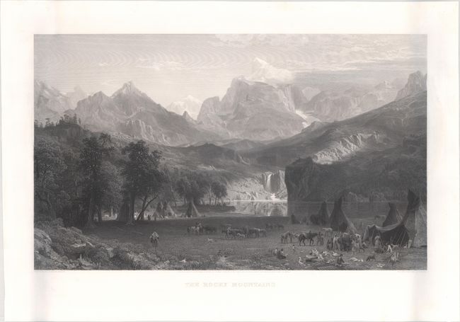
Auction 168, Lot 309
Subject: Rocky Mountains, Wyoming
The Rocky Mountains, 1866
Size: 27.8 x 18 inches (70.6 x 45.7 cm)
Estimate: $3,000 - $4,000
Stunning View of the Rocky Mountains and Native Indians by Albert Bierstadt
Unsold
Closed on 6/6/2018
23 lots