Subject: Philadelphia, Pennsylvania
Period: 1777 (dated)
Publication:
Color: Hand Color
Size:
17.8 x 23.2 inches
45.2 x 58.9 cm
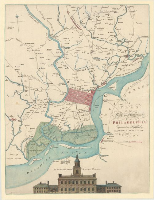
This important, Revolutionary War era map of Philadelphia, initially issued by Nicolas Scull and George Heap in 1752, was published by Matthias Albrecht Lotter under an Anglicized version of his name. The original Scull & Heap plan was made for use as a tool to promote settlement to the early city. Nicholas Scull, the surveyor general of Pennsylvania, handled the mapping, while George Heap created the perspective view of the State House. This updated version was issued by Lotter in response to demand for information about the region that was the center of the American Revolution. The map shows the early grid of the city, extending to the outlying areas, including Germantown and Derby with individual farms noted throughout. A handsome engraving of Independence Hall is shown at the bottom of the map under the title of its former name: "Elevation of the State House." William Faden published a third state of Scull and Heap's map, also in 1777.
References: cf. Nebenzahl (American Revolution) #26; Nebenzahl (Biblio) #131.
Condition: B+
On a watermarked sheet with a few minor stains. The sheet has been professionally remargined with leaf-casting. Presents very well.