Showing Featured Lots(remove filter)
Filtered by Category:United States(Show All Categories)
Showing results for:Auction 167
Catalog Archive
17 lots
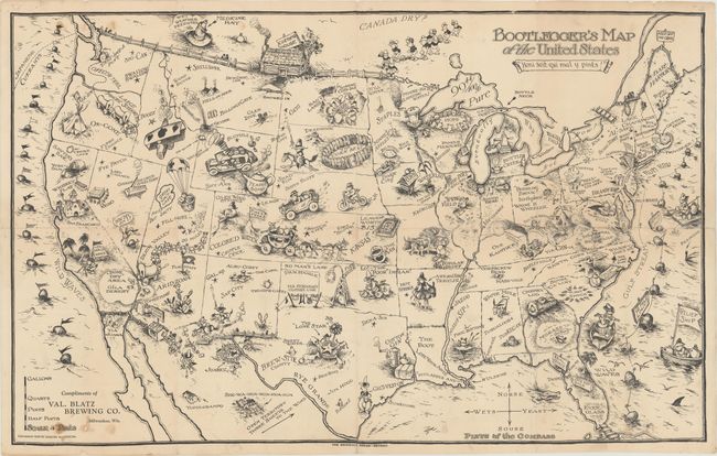
Auction 167, Lot 83
Subject: United States
Bootlegger's Map of the United States , 1926
Size: 33.9 x 21.3 inches (86.1 x 54.1 cm)
Estimate: $500 - $650
McCandlish's Humorous Prohibition Map
Sold for: $350
Closed on 3/28/2018
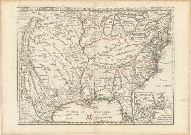
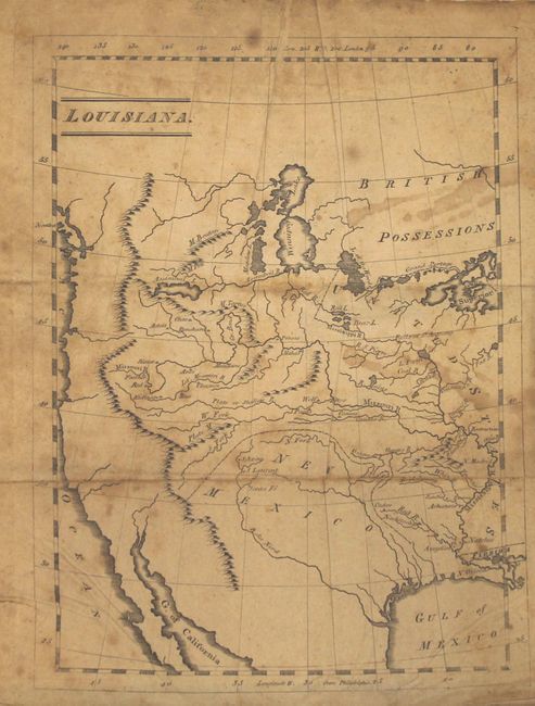
Auction 167, Lot 86
Subject: Colonial Eastern United States, Louisiana Territory
Delisle/Dezauche
Carte de la Louisiane et du Cours du Mississipi avec les Colonies Anglaises, 1782
Size: 25.4 x 19.1 inches (64.5 x 48.5 cm)
Estimate: $1,600 - $1,900
Delisle's Influential Map of the Louisiana Territory
Unsold
Closed on 3/28/2018
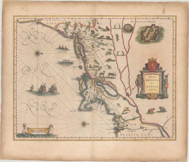
Auction 167, Lot 95
Subject: Colonial New England & Mid-Atlantic United States
Blaeu, Willem
Nova Belgica et Anglia Nova, 1638
Size: 19.9 x 15.3 inches (50.5 x 38.9 cm)
Estimate: $2,300 - $2,750
Important Map of Colonial New England and the Mid-Atlantic
Unsold
Closed on 3/28/2018
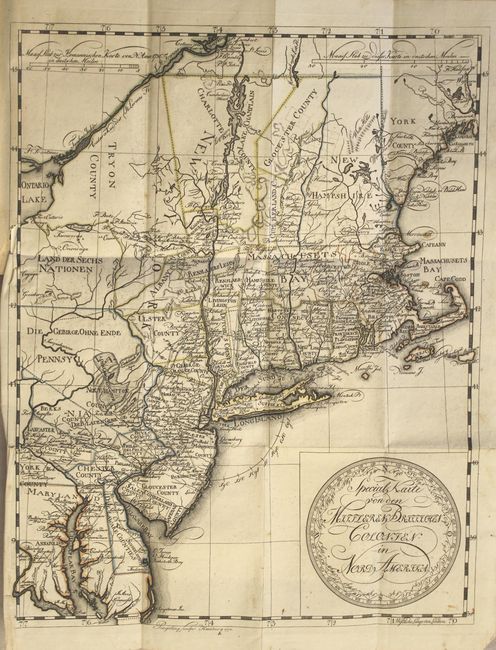
Auction 167, Lot 97
Subject: Colonial New England & Mid-Atlantic United States
Leiste/Pingeling
Special Karte von den Mittleren Britisshen Colonien in Nord Amerika... [bound in] Beschreibung des Brittischen Amerika zur Ersparung der Englischen Karten..., 1778
Size: 11.7 x 14.8 inches (29.7 x 37.6 cm)
Estimate: $1,800 - $2,100
Scarce Revolutionary War Map
Unsold
Closed on 3/28/2018
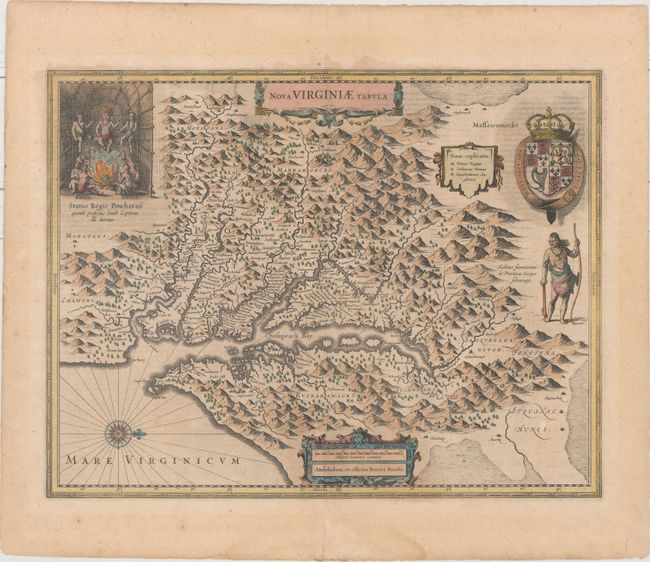
Auction 167, Lot 99
Subject: Colonial Mid-Atlantic United States
Hondius, Henricus
Nova Virginiae Tabula, 1636
Size: 19.5 x 15.1 inches (49.5 x 38.4 cm)
Estimate: $1,800 - $2,200
One of the Most Important 17th Century Maps of the Chesapeake Bay
Sold for: $1,000
Closed on 3/28/2018
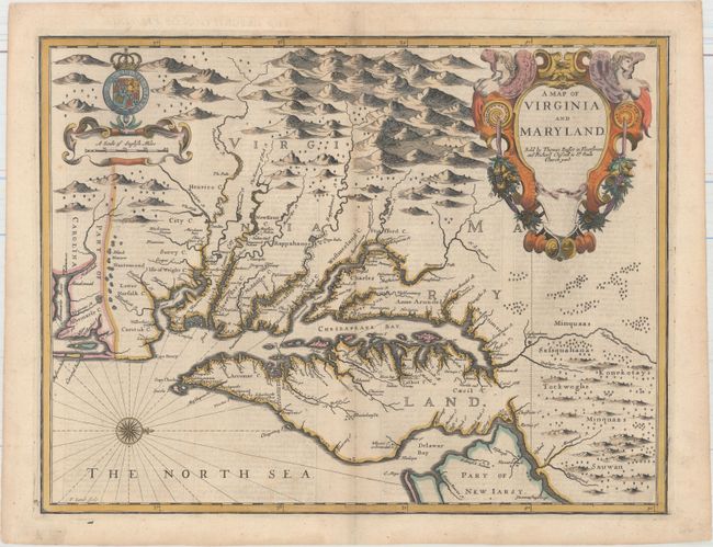
Auction 167, Lot 100
Subject: Colonial Mid-Atlantic United States
Speed/Lamb
A Map of Virginia and Maryland, 1676
Size: 19.4 x 14.9 inches (49.3 x 37.8 cm)
Estimate: $4,000 - $5,000
The First Printed Map to Draw Upon the Legendary Herrman Map of the Chesapeake Bay
Sold for: $3,000
Closed on 3/28/2018
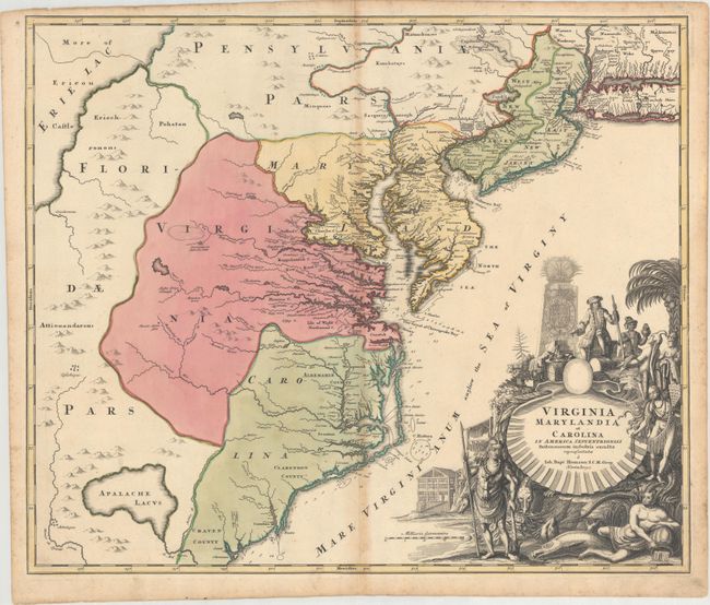
Auction 167, Lot 101
Subject: Colonial Mid-Atlantic United States
Homann, Johann Baptist
Virginia Marylandia et Carolina in America Septentrionali Britannorum Industria Excultae, 1714
Size: 23.1 x 19.3 inches (58.7 x 49 cm)
Estimate: $1,200 - $1,500
Map Created to Promote German Immigration to the New World
Sold for: $800
Closed on 3/28/2018
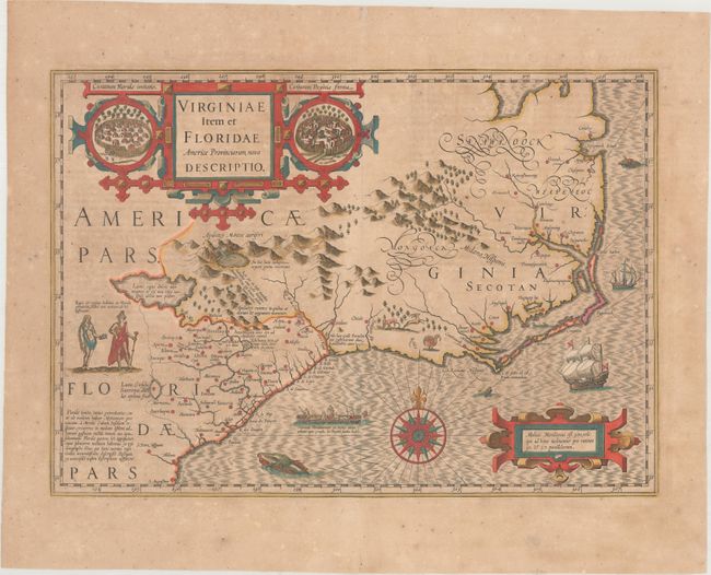
Auction 167, Lot 104
Subject: Colonial Southeastern United States
Hondius, Jodocus
Virginiae Item et Floridae Americae Provinciarum, Nova Descriptio, 1639
Size: 19.1 x 13.4 inches (48.5 x 34 cm)
Estimate: $1,600 - $1,900
A Seminal Map of the Southeast and Early American Cartography - Full Contemporary Color
Sold for: $1,200
Closed on 3/28/2018
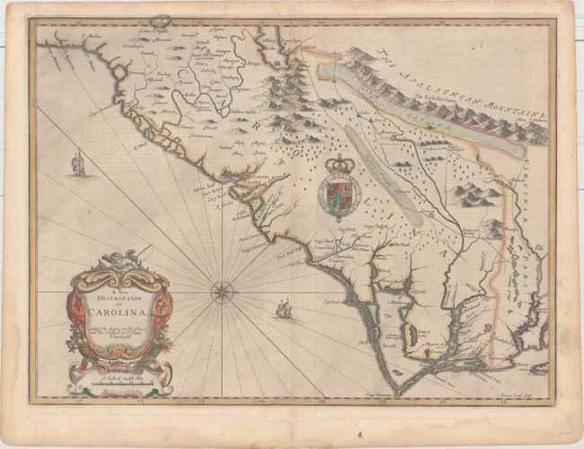
Auction 167, Lot 105
Subject: Colonial Southeastern United States
Speed/Lamb
A New Description of Carolina, 1676
Size: 20 x 14.8 inches (50.8 x 37.6 cm)
Estimate: $3,500 - $4,250
Speed's Map of the Carolinas Based Upon the Lords Proprietor's Map
Unsold
Closed on 3/28/2018
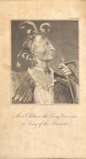
Auction 167, Lot 109
Subject: Southeastern United States
Bartram, William
Travels Through North and South Carolina, Georgia, East and West Florida, the Cherokee Country, the Extensive Territories of the Muscogulges or Creek Confederacy, and the Country of the Chactaws..., 1793
Size: 5.5 x 8.3 inches (14 x 21.1 cm)
Estimate: $2,750 - $3,500
Irish Edition of Bartram's Work on the Southeast
Unsold
Closed on 3/28/2018
Auction 167, Lot 124
Subject: Western United States
Gass, Patrick
Journal of the Voyages and Travels of a Corps of Discovery, Under the Command of Capt. Lewis and Capt. Clarke of the Army of the United States..., 1812
Size: 4.6 x 7.3 inches (11.7 x 18.5 cm)
Estimate: $5,500 - $7,000
Fourth Edition of the Earliest First-Hand Narrative of the Lewis & Clark Expedition
Sold for: $4,000
Closed on 3/28/2018
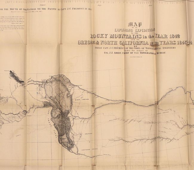
Auction 167, Lot 125
Subject: Western United States
Fremont/Preuss
Map of an Exploring Expedition to the Rocky Mountains in the Year 1842 and to Oregon & North California in the Years 1843-44 [with] Report of The Exploring Expedition to the Rocky Mountains…, 1845
Size: 51 x 30.5 inches (129.5 x 77.5 cm)
Estimate: $1,100 - $1,400
Fremont's Large Map of the American West
Unsold
Closed on 3/28/2018
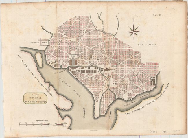
Auction 167, Lot 138
Subject: Washington, D.C.
Plan of the City of Washington, 1805
Size: 10.6 x 8.3 inches (26.9 x 21.1 cm)
Estimate: $1,200 - $1,500
Rare Scottish Plan of Washington
Unsold
Closed on 3/28/2018
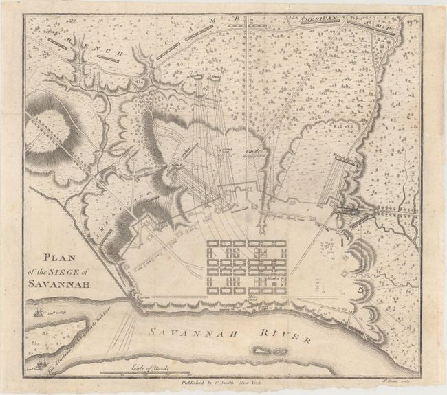
Auction 167, Lot 150
Subject: Savannah, Georgia, Revolutionary War
Smith, Charles
Plan of the Siege of Savannah, 1796
Size: 9.1 x 8.4 inches (23.1 x 21.3 cm)
Estimate: $2,000 - $2,300
Rare Revolutionary War Plan Showing the Siege of Savannah
Unsold
Closed on 3/28/2018
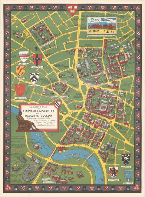
Auction 167, Lot 160
Subject: Massachusetts & New Hampshire
[Lot of 5] A Scott-Map of Harvard University and of Radcliffe College... [and] ... Boston Massachusetts [and] ... Concord Massachusetts... [and] ... the White Mountains of New Hampshire [and] Salem Massachusetts..., 1949-60
Size: See Description
Estimate: $350 - $450
A Wonderful Set of "Scott Maps"
Sold for: $375
Closed on 3/28/2018
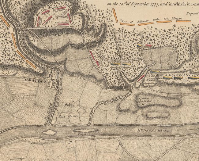
Auction 167, Lot 175
Subject: Colonial Saratoga, New York, Revolutionary War
Faden, William
Plan of the Position Which the Army Under Lt. Genl. Burgoine Took at Saratoga on the 10th of September 1777, and In Which It Remained Till the Convention Was Signed, 1780
Size: 18.7 x 8.6 inches (47.5 x 21.8 cm)
Estimate: $1,400 - $1,700
Important Revolutionary War Map of the 2nd Battle of Saratoga
Unsold
Closed on 3/28/2018
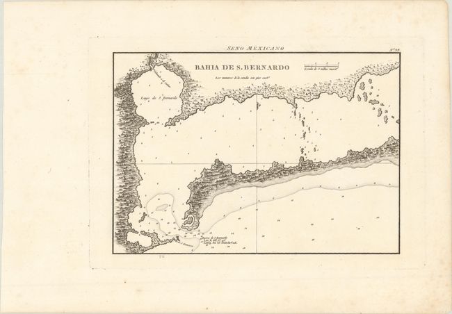
Auction 167, Lot 188
Subject: Matagorda Bay, Texas
Direccion de Hidrografia
Bahia de S. Bernardo, 1809
Size: 10.2 x 7.2 inches (25.9 x 18.3 cm)
Estimate: $550 - $700
First Engraved Map of Matagorda Bay
Sold for: $300
Closed on 3/28/2018
17 lots