Showing Featured Lots(remove filter)
Filtered by Category:United States(Show All Categories)
Showing results for:Auction 157
Catalog Archive
23 lots
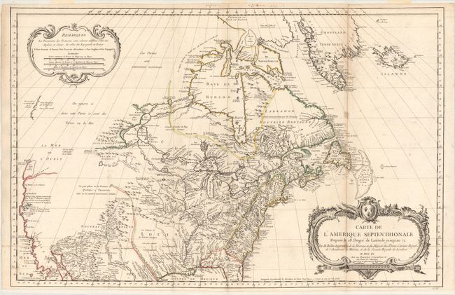
Auction 157, Lot 127
Subject: Colonial United States & Canada
Bellin, Jacques Nicolas
Carte de l'Amerique Septentrionale Depuis le 28 Degre de Latitude Jusqu'au 72, 1755
Size: 34 x 22 inches (86.4 x 55.9 cm)
Estimate: $1,500 - $1,800
NO RESERVE - Bellin's Important, Large Format Map of North America
Sold for: $950
Closed on 5/4/2016
Auction 157, Lot 128
Subject: United States & Canada
SDUK Society for the Diffusion of Useful Knowledge
[Lot of 15 - North America], 1832-34
Size: 12.3 x 15.1 inches (31.2 x 38.4 cm)
Estimate: $950 - $1,200
Matching Set of North America SDUK Maps
Sold for: $1,200
Closed on 5/4/2016
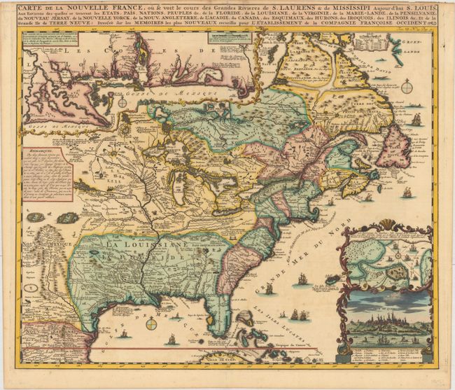
Auction 157, Lot 130
Subject: Colonial Eastern United States & Canada
Chatelain, Henry Abraham
Carte de la Nouvelle France, ou se voit le Cours des Grandes Rivieres de S. Laurens & de Mississipi Aujour d'hui S. Louis, aux Environs des Quelles se Trouvent les Etats, Pais, Nations, Peuples &c..., 1719
Size: 19.1 x 16.6 inches (48.5 x 42.2 cm)
Estimate: $2,200 - $2,500
One of the Most Informative 18th Century Maps of the French Possessions in North America
Sold for: $2,400
Closed on 5/4/2016
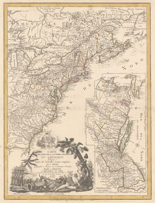
Auction 157, Lot 134
Subject: Colonial Eastern United States & Canada
Denis, Louis
Carte du Theatre de la Guerre Presente en Amerique Dressee d'Apres les Nouvelles Cartes Anglaises..., 1779
Size: 19.8 x 26.3 inches (50.3 x 66.8 cm)
Estimate: $4,750 - $6,000
Scarce American Revolutionary War Map
Sold for: $3,000
Closed on 5/4/2016
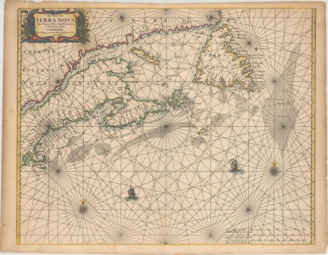
Auction 157, Lot 137
Subject: Canadian Maritimes & New England
Loon, Jan van
Pas-caerte van Terra Nova, Nova Francia, Nieuw Engeland en de Grote Rivier van Canada, 1666
Size: 21.2 x 16.8 inches (53.8 x 42.7 cm)
Estimate: $4,000 - $5,500
Very Influential Dutch Sea Chart of the Canadian Maritimes
Unsold
Closed on 5/4/2016
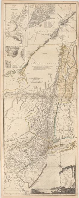
Auction 157, Lot 142
Subject: Colonial Northeastern United States & Quebec
Holland/Pownal
The Provinces of New York and New Jersey; with Part of Pensilvania, and the Province of Quebec, 1776
Size: 21.3 x 52.9 inches (54.1 x 134.4 cm)
Estimate: $5,500 - $7,000
Thomas Jefferys' Important Revolutionary War Period Map
Unsold
Closed on 5/4/2016
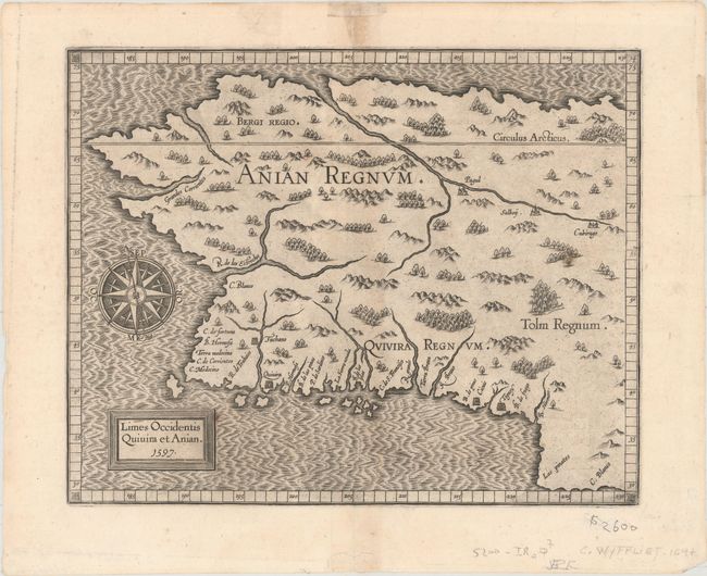
Auction 157, Lot 147
Subject: Alaska & Western Canada
Wytfliet, Cornelis
Limes Occidentis Quivira et Anian, 1597
Size: 11.4 x 9.2 inches (29 x 23.4 cm)
Estimate: $2,200 - $2,500
Early and Imaginary Map of Alaska and the Northwest Passage
Sold for: $1,500
Closed on 5/4/2016
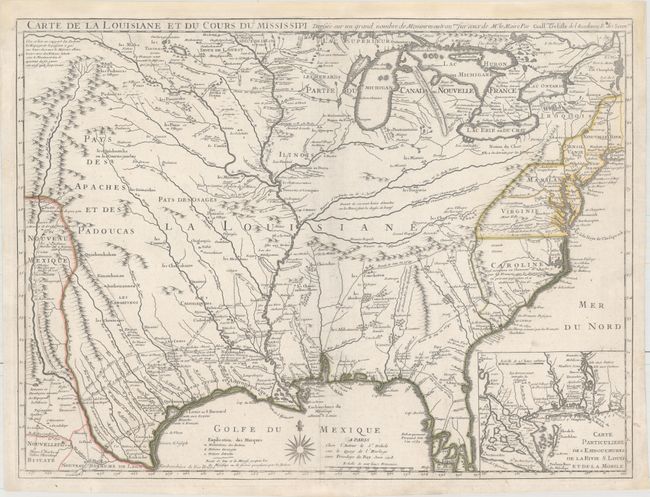
Auction 157, Lot 160
Subject: Colonial Eastern United States
Delisle, Guillaume
Carte de la Louisiane et du Cours du Mississipi Dressee sur un Grand Nombre de Memoires Entr'autres sur ceux de Mr. le Maire, 1718
Size: 25.5 x 19.2 inches (64.8 x 48.8 cm)
Estimate: $10,000 - $12,000
A Foundation Map for the Mississippi Valley and the First Appearance of Texas on a Printed Map
Sold for: $6,000
Closed on 5/4/2016
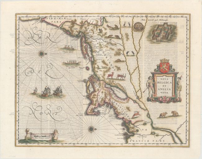
Auction 157, Lot 173
Subject: Colonial New England & Mid-Atlantic
Blaeu, Willem
Nova Belgica et Anglia Nova, 1642
Size: 19.9 x 15.3 inches (50.5 x 38.9 cm)
Estimate: $2,750 - $3,500
Important Map of Colonial New England and the Mid-Atlantic
Sold for: $2,000
Closed on 5/4/2016
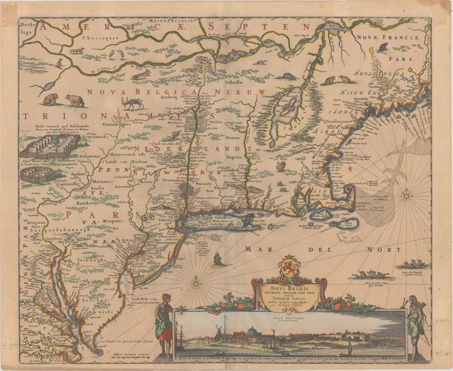
Auction 157, Lot 175
Subject: Colonial New England & Mid-Atlantic
Visscher, Nicolas
Novi Belgii Novaeque Angliae nec non Partis Virginiae Tabula Multis in Locis Emendata, 1684
Size: 21.8 x 18.4 inches (55.4 x 46.7 cm)
Estimate: $6,000 - $7,500
Visscher's Influential Map with Early View of New York City
Sold for: $4,500
Closed on 5/4/2016
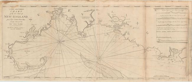
Auction 157, Lot 183
Subject: Colonial New England - United States
Mount & Page
[On 2 Sheets] A New and Correct Chart of the Sea Coast of New-England, from Cape Codd to Casco Bay..., 1764
Size: 23.1 x 18.7 inches (58.7 x 47.5 cm)
Estimate: $3,000 - $3,750
Rare Chart of the Coast of New England by Captain Barnsley
Unsold
Closed on 5/4/2016
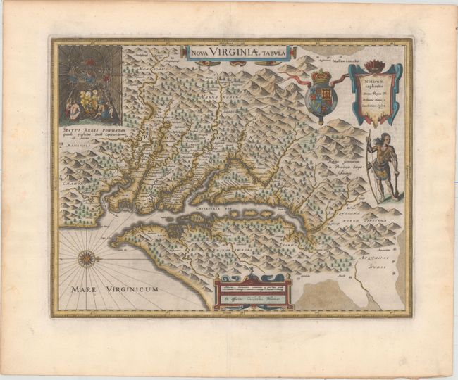
Auction 157, Lot 188
Subject: Colonial Mid-Atlantic United States
Hondius/Blaeu
Nova Virginiae Tabula, 1643
Size: 18.9 x 14.8 inches (48 x 37.6 cm)
Estimate: $2,400 - $3,000
One of the Most Important 17th Century Maps of the Chesapeake Bay
Sold for: $1,800
Closed on 5/4/2016
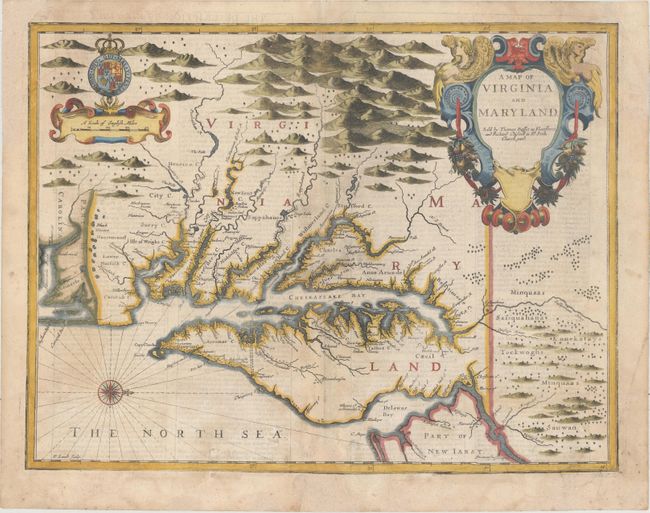
Auction 157, Lot 189
Subject: Colonial Mid-Atlantic United States
Speed/Lamb
A Map of Virginia and Maryland, 1676
Size: 19.6 x 15 inches (49.8 x 38.1 cm)
Estimate: $3,500 - $4,250
The First Printed Map to Draw Upon the Legendary Herrman Map of the Chesapeake Bay
Sold for: $2,500
Closed on 5/4/2016
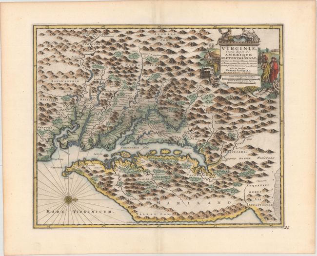
Auction 157, Lot 192
Subject: Colonial Mid-Atlantic United States
Aa, Pieter van der
Virginie, Grande Region de l'Amerique Septentrionale, avec tous Ses Bourgs, Hameaux, Rivieres et Bayes..., 1729
Size: 14.1 x 11.4 inches (35.8 x 29 cm)
Estimate: $1,900 - $2,200
Rare Derivative of John Smith's Map of the Chesapeake Bay
Unsold
Closed on 5/4/2016
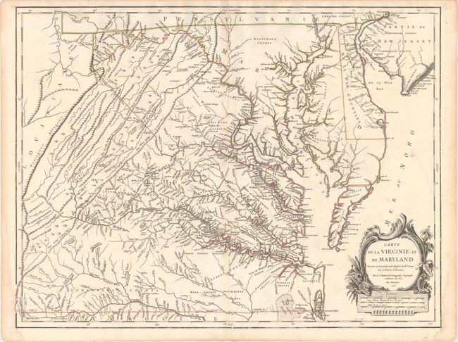
Auction 157, Lot 194
Subject: Colonial Mid-Atlantic United States
Robert de Vaugondy, Didier
Carte de la Virginie et du Maryland Dressee sur la Grande Carte Angloise de Mrs. Josue Fry et Pierre Jefferson..., 1755
Size: 25.4 x 19.1 inches (64.5 x 48.5 cm)
Estimate: $2,750 - $3,500
First State of Robert de Vaugondy's Essential Map of Virginia and Maryland
Sold for: $2,000
Closed on 5/4/2016
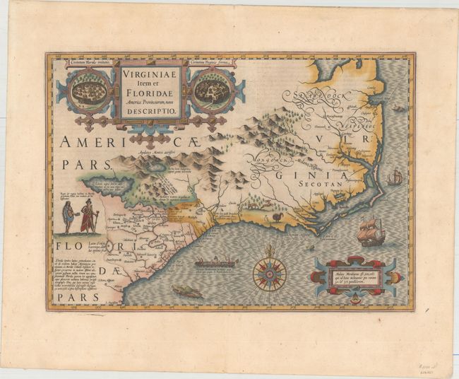
Auction 157, Lot 206
Subject: Colonial Southeast United States
Hondius, Jodocus
Virginiae Item et Floridae Americae Provinciarum, Nova Descriptio, 1638
Size: 19.2 x 13.6 inches (48.8 x 34.5 cm)
Estimate: $2,400 - $3,000
A Seminal Map of the Southeast and Early American Cartography
Sold for: $1,500
Closed on 5/4/2016
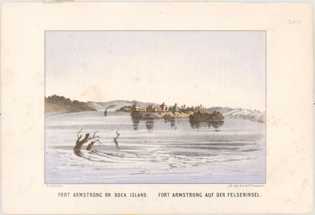
Auction 157, Lot 234
Subject: Mississippi River
Lewis, Henry
[Lot of 14 - Prints of the Mississippi River], 1856
Size: 7.8 x 5.4 inches (19.8 x 13.7 cm)
Estimate: $1,600 - $1,900
Rare, Early Color Plates of the Mississippi River
Sold for: $800
Closed on 5/4/2016
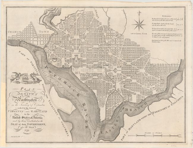
Auction 157, Lot 269
Subject: Washington, D.C.
Reid, John
Plan of the City of Washington in the Territory of Columbia Ceded by the States of Virginia and Maryland to the United States of America and by Them Established as the Seat of Their Government, After the Year 1800, 1796
Size: 20.7 x 15.8 inches (52.6 x 40.1 cm)
Estimate: $2,750 - $3,500
Rare, Early Large Format Map of Washington D.C.
Sold for: $2,000
Closed on 5/4/2016
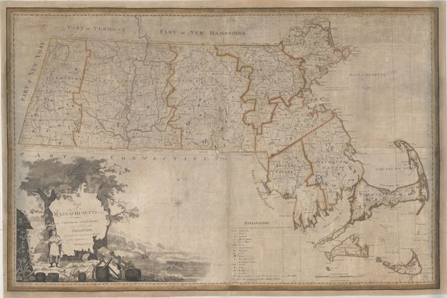
Auction 157, Lot 291
Subject: Massachusetts
Carleton, Osgood
Map of Massachusetts Proper Compiled from Actual Surveys Made by Order of the General Court, and Under the Inspection of Agents of Their Appointment , 1801
Size: 44.9 x 30.3 inches (114 x 77 cm)
Estimate: $12,000 - $14,000
Landmark Map of Massachusetts - First Edition of the First Official Map of the State
Unsold
Closed on 5/4/2016
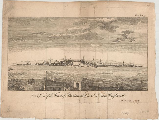
Auction 157, Lot 295
Subject: Boston, Massachusetts
A View of the Town of Boston the Capital of New England, 1787
Size: 9.2 x 4.9 inches (23.4 x 12.4 cm)
Estimate: $800 - $950
Rare Edition of Boston View with American Flag
Unsold
Closed on 5/4/2016
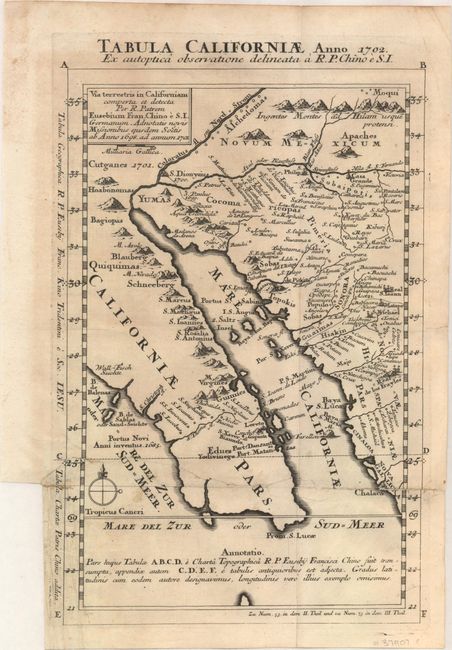
Auction 157, Lot 346
Subject: Southwestern United States & Mexico
Kino, Eusebio Francisco, SJ
Tabula Californiae, Anno 1702. Ex Autoptica Observatione Delineata a R.P. Chino e S.I., 1702
Size: 8.7 x 13.4 inches (22.1 x 34 cm)
Estimate: $1,600 - $2,000
NO RESERVE - Kino's Scarce Second Map of Lower California
Sold for: $500
Closed on 5/4/2016
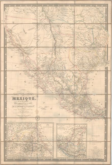
Auction 157, Lot 349
Subject: Western United States & Mexico, Texas, California
Brue, Adrien Hubert
Nouvelle Carte du Mexique, et d'une Partie des Provinces Unies de l'Amerique Centrale..., 1840
Size: 26 x 37.1 inches (66 x 94.2 cm)
Estimate: $6,000 - $7,500
Brue's Landmark Map of the West Featuring the Republic of Texas
Sold for: $2,740
Closed on 5/4/2016
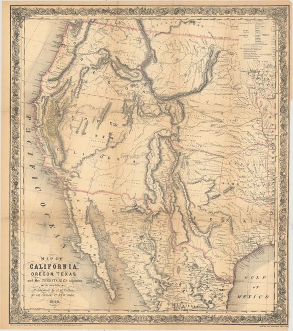
Auction 157, Lot 351
Subject: Western United States & Mexico
Colton, Joseph Hutchins
Map of California, Oregon, Texas, and the Territories Adjoining with Routes &c., 1849
Size: 18.1 x 20.8 inches (46 x 52.8 cm)
Estimate: $1,400 - $1,700
Colton's Map Depicting the Gold Region of California
Sold for: $2,000
Closed on 5/4/2016
23 lots