Showing Featured Lots(remove filter)
Filtered by Category:United States(Show All Categories)
Showing results for:Auction 146
Catalog Archive
23 lots
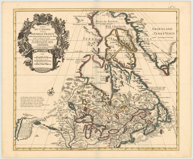
Auction 146, Lot 121
Subject: Colonial United States & Canada
Delisle/Covens & Mortier
Carte du Canada ou de la Nouvelle France et des Decouvertes quiy ont ete Faites..., 1730
Size: 22.6 x 19.3 inches (57.4 x 49 cm)
Estimate: $1,400 - $1,700
One of the most influential maps of Canada, the Great Lakes and Upper Midwest
Sold for: $1,300
Closed on 9/4/2013
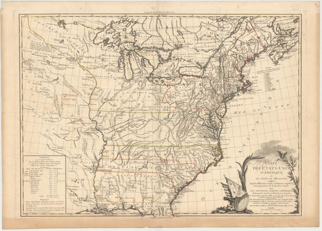
Auction 146, Lot 150
Subject: Eastern United States
Brion de la Tour, Louis
Carte des Etats-Unis d'Amerique et du Cours du Mississipi…, 1784
Size: 27.5 x 20 inches (69.9 x 50.8 cm)
Estimate: $3,000 - $3,750
One of the Earliest Maps of the New United States
Unsold
Closed on 9/4/2013
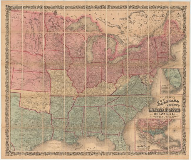
Auction 146, Lot 157
Subject: Eastern United States
Colton, Joseph Hutchins
Colton's New Railroad & County Map of the United States, 1862
Size: 39.5 x 33 inches (100.3 x 83.8 cm)
Estimate: $1,100 - $1,300
Rare Colton Civil War Map for a British Audience
Sold for: $700
Closed on 9/4/2013
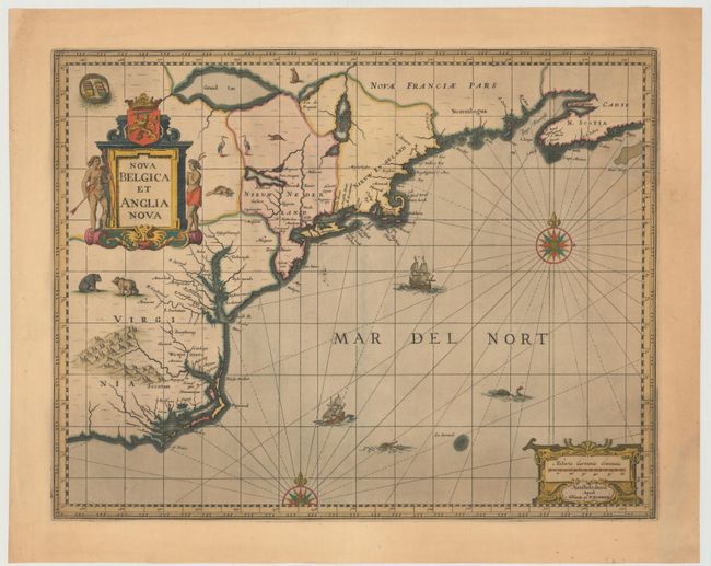
Auction 146, Lot 159
Subject: Colonial New England & Mid-Atlantic United States
Jansson/Valck & Schenk
Nova Belgica et Anglia Nova, 1694
Size: 19.5 x 15 inches (49.5 x 38.1 cm)
Estimate: $2,100 - $2,400
Jansson's Influential Map of the East Coast
Unsold
Closed on 9/4/2013
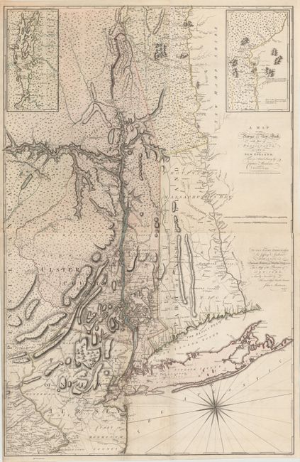
Auction 146, Lot 161
Subject: Colonial New England & Mid-Atlantic
Montresor, John
[On 2 Sheets] A Map of the Province of New York, with Part of Pensilvania, and New England..., 1775
Size: 36.2 x 28.5 inches (91.9 x 72.4 cm)
Estimate: $9,000 - $11,000
An Important Revolutionary War Period Map
Sold for: $5,500
Closed on 9/4/2013
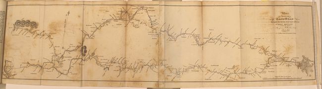
Auction 146, Lot 162
Subject: New England, Railroads
Report of the Board of Directors of Internal Improvements of the State of Massachusetts on the Practicability and Expediency of a Rail-Road from Boston to the Hudson River..., 1829
Size: 5.7 x 9.1 inches (14.5 x 23.1 cm)
Estimate: $800 - $1,000
Sold for: $500
Closed on 9/4/2013
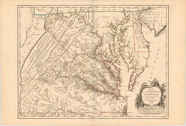
Auction 146, Lot 164
Subject: Colonial Mid-Atlantic United States, Virginia & Maryland
Robert de Vaugondy, Didier
Carte de la Virginie et du Maryland Dressee sur la Grande Carte Angloise de Mrs. Josue Fry et Pierre Jefferson, 1755
Size: 25.2 x 19.1 inches (64 x 48.5 cm)
Estimate: $3,250 - $4,000
An Essential Map of Virginia and Maryland
Sold for: $2,750
Closed on 9/4/2013
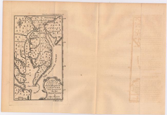
Auction 146, Lot 165
Subject: Colonial Mid-Atlantic United States
Mynde, James
A Map of That Part of America Where a Degree of Latitude Was Measured for the Royal Society by Cha: Mason & Jere: Dixon, 1769
Size: 3.9 x 6.6 inches (9.9 x 16.8 cm)
Estimate: $500 - $650
Rare First Issue of the Mason-Dixon Survey
Sold for: $850
Closed on 9/4/2013
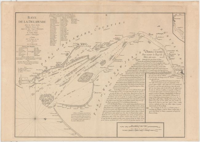
Auction 146, Lot 166
Subject: Colonial Mid-Atlantic, Delaware Bay
Le Rouge, George Louis
Baye de la Delaware avec les Ports, Sondes, Dangers, Bancs &c. depuis les Caps Jusqu'a Philadelphie…, 1777
Size: 25.8 x 19 inches (65.5 x 48.3 cm)
Estimate: $1,800 - $2,200
The Most Accurate Chart of Delaware Bay in the 18th Century
Unsold
Closed on 9/4/2013
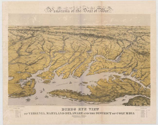
Auction 146, Lot 170
Subject: Mid-Atlantic, Civil War
Bachmann, John
Panorama of the Seat of War, Birds Eye View of Virginia, Maryland, Delaware, and the District of Columbia, 1861
Size: 27.8 x 18 inches (70.6 x 45.7 cm)
Estimate: $2,000 - $2,300
Sold for: $1,900
Closed on 9/4/2013
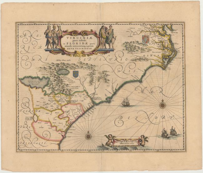
Auction 146, Lot 171
Subject: Colonial Southeast
Jansson, Jan
Virginiae Partis Australis, et Floridae Partis Orientalis, Interjacentiumque Regionum Nova Descriptio, 1647
Size: 19.8 x 15.2 inches (50.3 x 38.6 cm)
Estimate: $1,500 - $1,800
Unsold
Closed on 9/4/2013
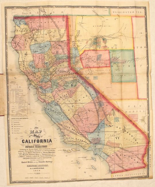
Auction 146, Lot 189
Subject: California, Nevada
Ransom & Doolittle
A New Map of the State of California and Nevada Territory..., 1863
Size: 21.5 x 26.3 inches (54.6 x 66.8 cm)
Estimate: $4,750 - $6,000
Early and Important Map of the Western Mining Districts
Unsold
Closed on 9/4/2013
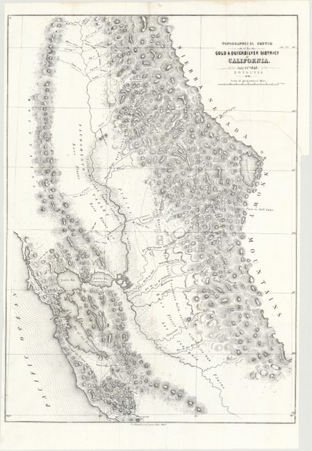
Auction 146, Lot 195
Subject: California
Ord, E. O. C.
Topographical Sketch of the Gold & Quicksilver District of California, 1848
Size: 15.5 x 21.5 inches (39.4 x 54.6 cm)
Estimate: $400 - $500
Sold for: $550
Closed on 9/4/2013
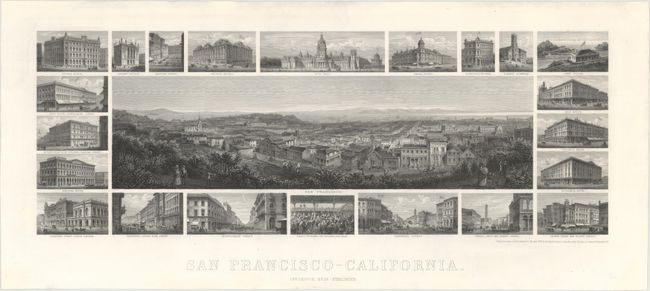
Auction 146, Lot 206
Subject: San Francisco, California
San Francisco - California, 1874
Size: 24.7 x 10.8 inches (62.7 x 27.4 cm)
Estimate: $4,000 - $5,000
Sold for: $2,600
Closed on 9/4/2013
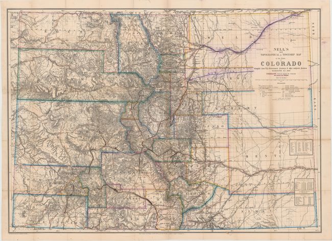
Auction 146, Lot 212
Subject: Colorado
Nell, Louis
Nell's New Topographical & Township Map of the State of Colorado…, 1880
Size: 37.8 x 27.5 inches (96 x 69.9 cm)
Estimate: $3,250 - $4,000
Louis Nell's First Edition Map of Colorado
Unsold
Closed on 9/4/2013
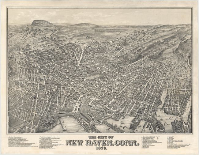
Auction 146, Lot 213
Subject: New Haven, Connecticut
Bailey, O. H. & Co.
The City of New Haven, Conn. 1879., 1879
Size: 37.4 x 25.7 inches (95 x 65.3 cm)
Estimate: $8,000 - $10,000
Extremely Rare View of New Haven and Yale College
Unsold
Closed on 9/4/2013
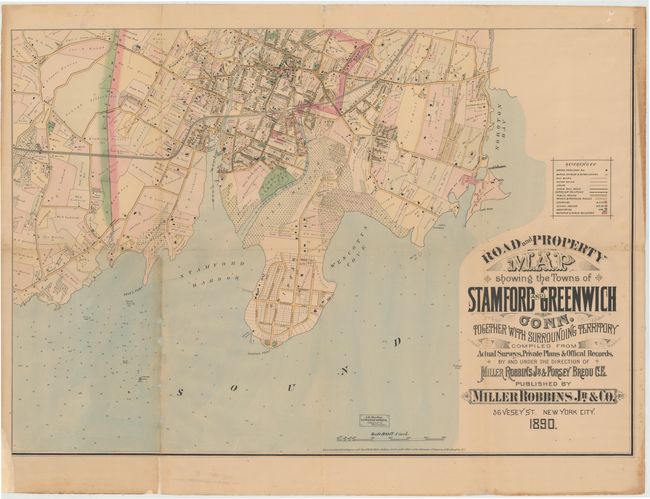
Auction 146, Lot 214
Subject: Southwest Connecticut
[On 3 of 4 Sheets] Road and Property Map Showing the Towns of Stamford and Greenwich Conn. Together with Surrounding Territory…, 1890
Size: 35.2 x 24.3 inches (89.4 x 61.7 cm)
Estimate: $1,600 - $1,900
Unsold
Closed on 9/4/2013
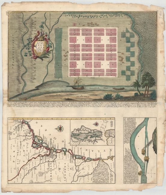
Auction 146, Lot 220
Subject: Georgia
Seutter, Matthias
Plan von Neu Ebenezer [on sheet with] [Untitled - Map of Southeast], 1747
Size: 19.8 x 12 inches (50.3 x 30.5 cm)
Estimate: $7,000 - $8,500
Rare Plan of Georgia Settlement New Ebenezer
Unsold
Closed on 9/4/2013
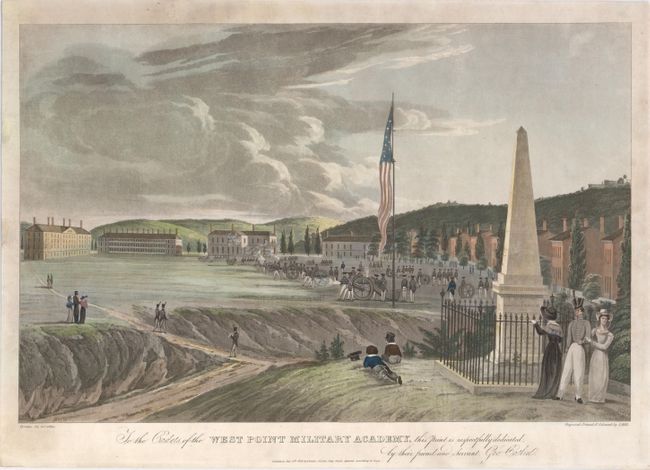
Auction 146, Lot 241
Subject: West Point Military Academy, New York
Catlin, George
[Looking South - Artillery Drill] To the Cadets of the West Point Military Academy This Print Is Respectfully Dedicated by Their Friend and Servant Geo. Catlin, 1828
Size: 18.3 x 13.2 inches (46.5 x 33.5 cm)
Estimate: $2,750 - $3,500
Sold for: $2,000
Closed on 9/4/2013
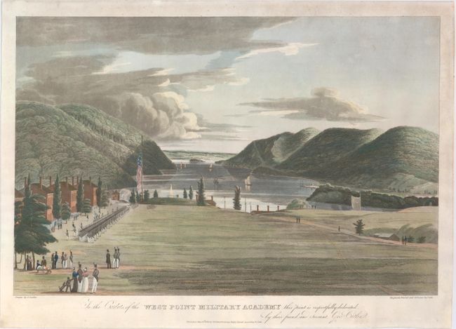
Auction 146, Lot 242
Subject: West Point Military Academy, New York
Catlin, George
[Looking North - Military Drill] To the Cadets of the West Point Military Academy This Print Is Respectfully Dedicated by Their Friend and Servant Geo. Catlin, 1828
Size: 18.3 x 13.2 inches (46.5 x 33.5 cm)
Estimate: $2,750 - $3,500
Sold for: $2,200
Closed on 9/4/2013
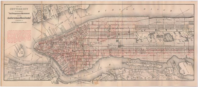
Auction 146, Lot 245
Subject: New York City, New York
[Lot of 2] Liquordom in New York City [and] Map of New York City to Accompany "the Temperance Movement or the Conflict Between Man & Alcohol", 1883-86
Size: See Description
Estimate: $150 - $200
Sold for: $75
Closed on 9/4/2013
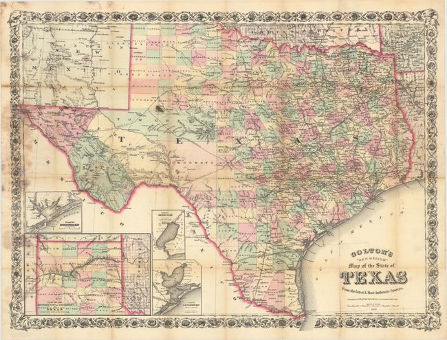
Auction 146, Lot 263
Subject: Texas
Colton, G.W. & C.B.
Colton's "New Medium" Map of the State of Texas from the Latest & Most Authentic Sources, 1879
Size: 25.5 x 19.3 inches (64.8 x 49 cm)
Estimate: $2,000 - $2,500
Rare Pocket Map of Texas
Unsold
Closed on 9/4/2013
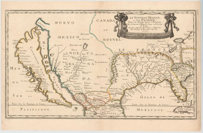
Auction 146, Lot 269
Subject: Colonial United States & Mexico
Sanson, Nicolas
Le Nouveau Mexique, et la Floride…, 1656
Size: 21.5 x 12.3 inches (54.6 x 31.2 cm)
Estimate: $5,500 - $7,000
First Edition of Sanson's Important Map of the American Southwest
Sold for: $4,000
Closed on 9/4/2013
23 lots