Showing Featured Lots(remove filter)
Filtered by Category:United States(Show All Categories)
Showing results for:Auction 114
Catalog Archive
19 lots
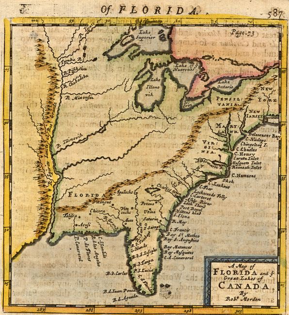
Auction 114, Lot 117
Subject: Colonial United States and Canada
Morden, Robert
A map of Florida and ye Great Lakes of Canada, 1693
Size: 5 x 5.2 inches (12.7 x 13.2 cm)
Estimate: $400 - $450
Sold for: $700
Closed on 3/1/2006
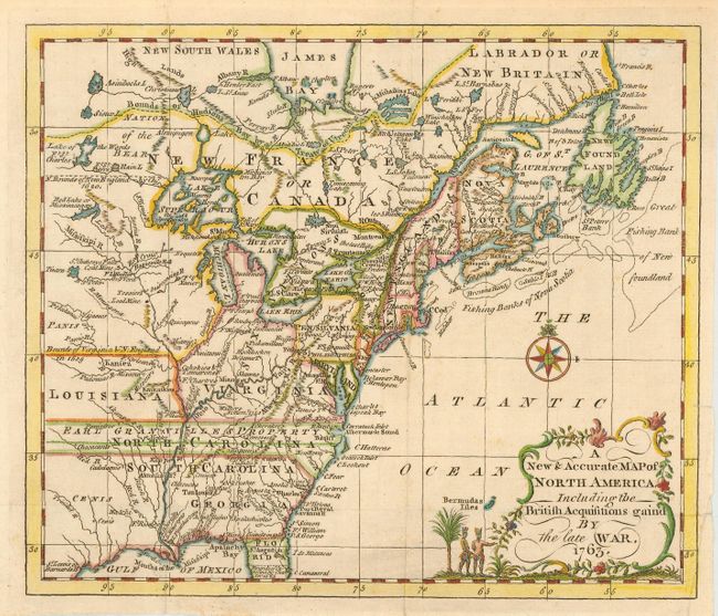
Auction 114, Lot 120
Subject: Colonial United States and Canada
Entick, John
A New & Accurate Map of North America Including the British Acquisitions gain'd By the late War, 1763
Size: 9 x 7.6 inches (22.9 x 19.3 cm)
Estimate: $375 - $450
Sold for: $500
Closed on 3/1/2006
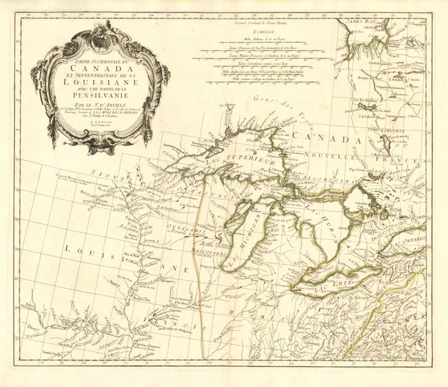
Auction 114, Lot 122
Subject: Colonial Great Lakes
D'Anville/Santini
Partie Occidentale du Canada et Septentrionale de la Louisiane avec une partie de la Pensilvanie, 1775
Size: 22.5 x 19 inches (57.2 x 48.3 cm)
Estimate: $1,000 - $1,200
Sold for: $1,100
Closed on 3/1/2006
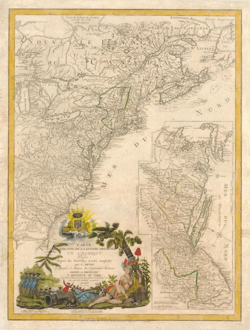
Auction 114, Lot 123
Subject: Colonial United States and Canada
Denis, Louis
Carte du Theatre de la Guerre Presente en Amerique Dressee d'apres les Nouvelles Cartes Anglaises, 1779
Size: 19.5 x 26 inches (49.5 x 66 cm)
Estimate: $3,000 - $4,000
Unsold
Closed on 3/1/2006
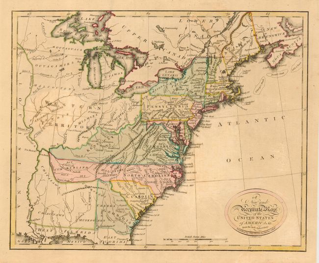
Auction 114, Lot 143
Subject: United States - Eastern
Brown, Thomas
A New and Accurate Map of the United States of America, &c. from the best Authorities, 1790
Size: 13.3 x 10.8 inches (33.8 x 27.4 cm)
Estimate: $700 - $800
Sold for: $600
Closed on 3/1/2006
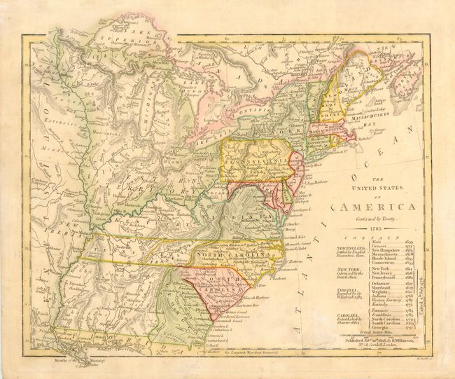
Auction 114, Lot 145
Subject: United States - Eastern
Wilkinson, Robert
The United States of America Confirmed by Treaty 1783, 1806
Size: 11 x 9.3 inches (27.9 x 23.6 cm)
Estimate: $450 - $500
Sold for: $450
Closed on 3/1/2006
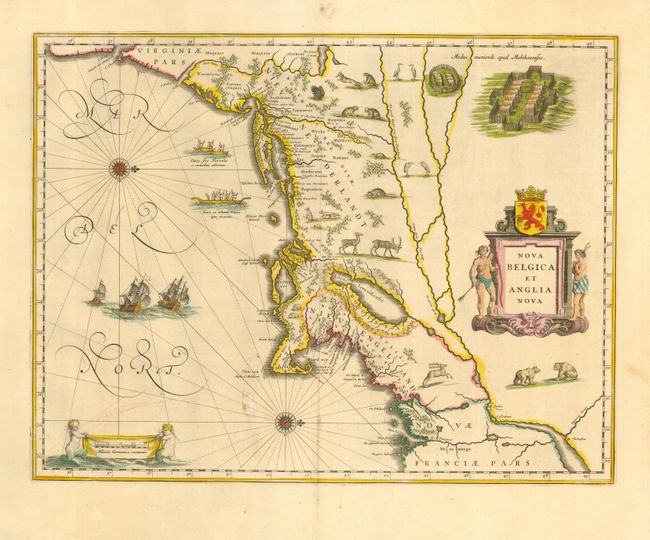
Auction 114, Lot 152
Subject: Colonial New England
Blaeu, Willem
Nova Belgica et Anglia Nova, 1640
Size: 19.7 x 15.2 inches (50 x 38.6 cm)
Estimate: $3,000 - $3,500
Sold for: $2,750
Closed on 3/1/2006
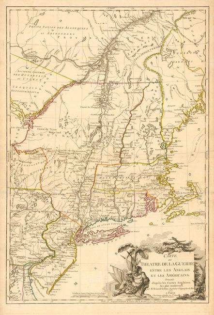
Auction 114, Lot 155
Subject: Colonial Northeast
Brion de la Tour, Louis
Carte du Theatre de la Guerre Entre les Anglais et les Americains: Dressee d'apres les Cartes Anglaises les plus modernes, 1777
Size: 20 x 29.3 inches (50.8 x 74.4 cm)
Estimate: $4,000 - $5,000
Sold for: $3,250
Closed on 3/1/2006
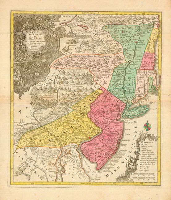
Auction 114, Lot 158
Subject: Colonial Mid Atlantic
Seutter/Lotter
Pensylvania Nova Jersey et Nova York cum Regionibus ad Fluvium Delaware in America Sitis…, 1750
Size: 19.5 x 22.5 inches (49.5 x 57.2 cm)
Estimate: $2,400 - $2,750
Sold for: $1,800
Closed on 3/1/2006
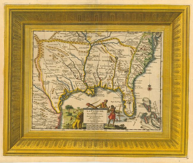
Auction 114, Lot 162
Subject: Colonial South
Aa, Pieter van der
La Floride, Suivant les Nouvelles Observations…, 1729
Size: 16 x 13.2 inches (40.6 x 33.5 cm)
Estimate: $2,000 - $2,300
Sold for: $1,900
Closed on 3/1/2006
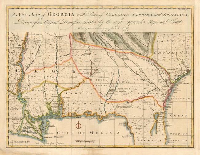
Auction 114, Lot 168
Subject: Colonial Southeast - Georgia
Bowen, Emanuel
A New Map of Georgia with Part of Carolina, Florida and Louisiana, 1748
Size: 18.8 x 14.3 inches (47.8 x 36.3 cm)
Estimate: $3,000 - $3,500
Sold for: $2,750
Closed on 3/1/2006
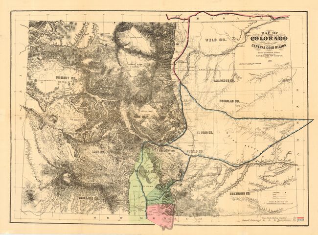
Auction 114, Lot 219
Subject: Colorado
Gilpin, William
Map of Colorado Embracing the Central Gold Region. Drawn by Frederick J. Ebert under direction of the Governor Wm. Gilpin., 1869
Size: 25.8 x 18.5 inches (65.5 x 47 cm)
Estimate: $1,400 - $1,800
Sold for: $1,000
Closed on 3/1/2006
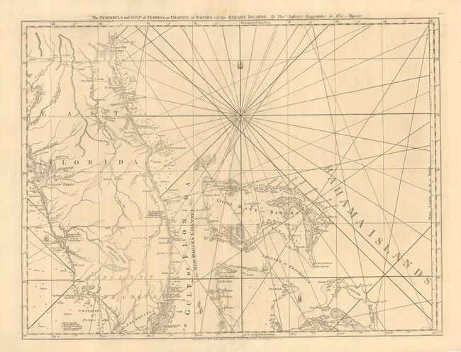
Auction 114, Lot 226
Subject: Colonial Florida and Bahamas
Jefferys, Thomas
The Peninsula and Gulf of Florida or Channel of Bahama with the Bahama Islands, 1775
Size: 24.5 x 19 inches (62.2 x 48.3 cm)
Estimate: $1,800 - $2,000
Sold for: $1,900
Closed on 3/1/2006
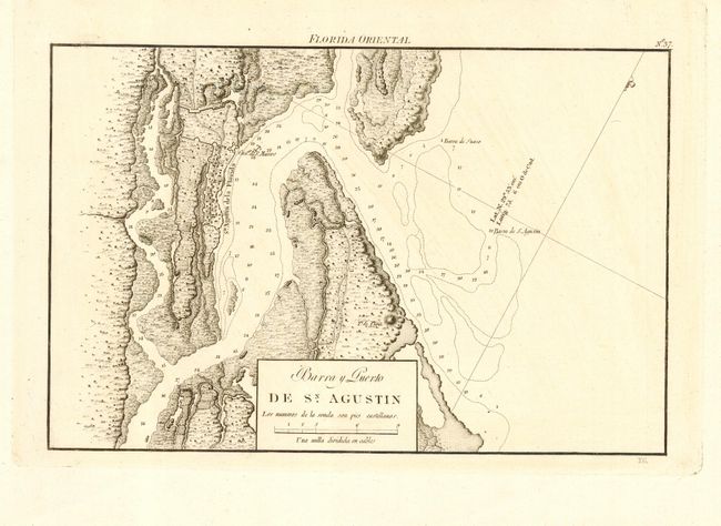
Auction 114, Lot 227
Subject: Florida
Direccion de Hidrografia
Barra y Puerto de Sn. Augustin, 1809
Size: 10.5 x 7 inches (26.7 x 17.8 cm)
Estimate: $750 - $850
Sold for: $850
Closed on 3/1/2006
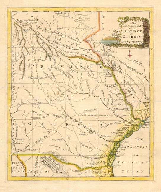
Auction 114, Lot 228
Subject: Colonial Georgia
Anon.
A New and Accurate Map of the Province of Georgia in North America, 1779
Size: 10.8 x 12.8 inches (27.4 x 32.5 cm)
Estimate: $600 - $700
Sold for: $650
Closed on 3/1/2006
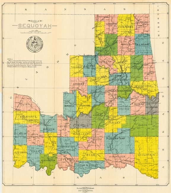
Auction 114, Lot 263
Subject: Oklahoma
U.S. Government
State of Sequoyah, 1905
Size: 14.8 x 16 inches (37.6 x 40.6 cm)
Estimate: $700 - $900
Sold for: $1,000
Closed on 3/1/2006
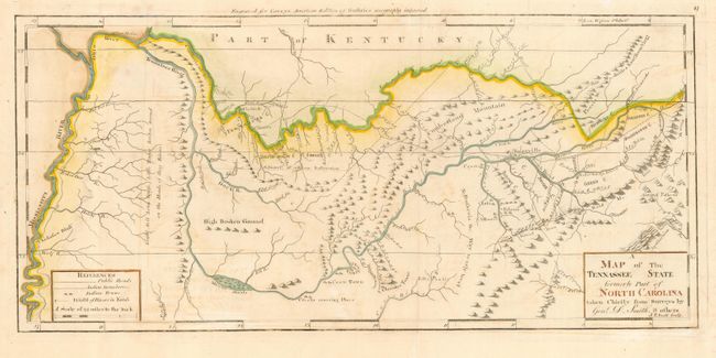
Auction 114, Lot 275
Subject: Tennessee
Carey, Mathew
A Map of the Tennassee State formerly Part of North Carolina taken Chiefly from Surveys by Genl. D. Smith & others, 1800
Size: 20.3 x 9.5 inches (51.6 x 24.1 cm)
Estimate: $1,500 - $1,800
Sold for: $850
Closed on 3/1/2006
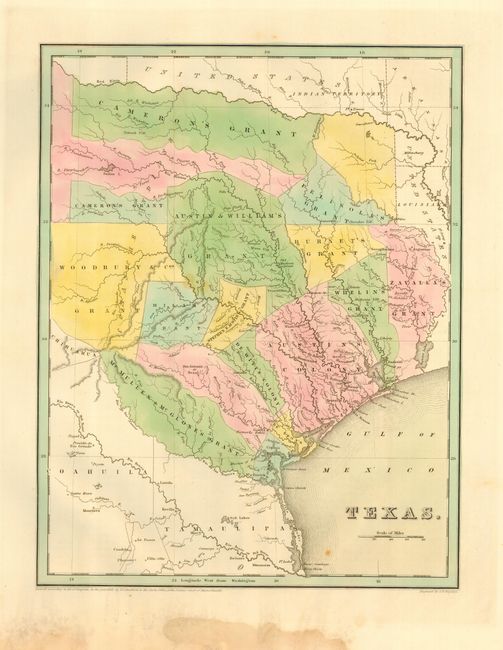
Auction 114, Lot 276
Subject: Texas
Bradford, Thomas Gamaliel
Texas, 1838
Size: 11 x 14.3 inches (27.9 x 36.3 cm)
Estimate: $2,300 - $2,750
Sold for: $3,000
Closed on 3/1/2006
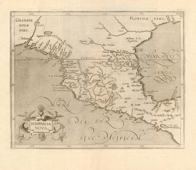
Auction 114, Lot 290
Subject: Colonial Southwest & Mexico
Wytfliet, Cornelis
Hispania Nova, 1598
Size: 11.3 x 9 inches (28.7 x 22.9 cm)
Estimate: $1,000 - $1,200
Sold for: $850
Closed on 3/1/2006
19 lots