Filtered by Category:Canada(Show All Categories)
Showing results for:Auction 203
Catalog Archive
30 lots
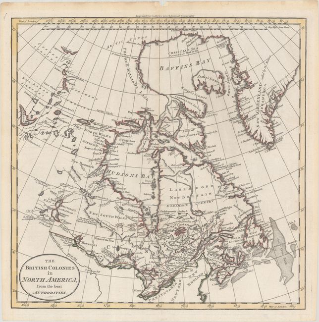
Auction 203, Lot 75
Subject: Eastern Canada
Guthrie, William
The British Colonies in North America, from the Best Authorities, 1795
Size: 13.3 x 13.2 inches (33.8 x 33.5 cm)
Estimate: $140 - $170
Sold for: $100
Closed on 4/23/2025
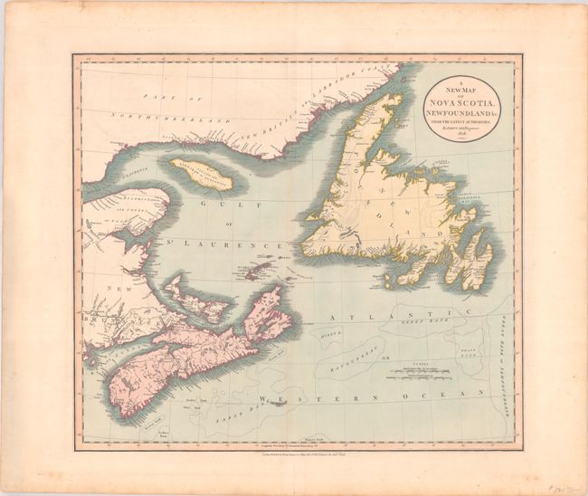
Auction 203, Lot 76
Subject: Eastern Canada
Cary, John
A New Map of Nova Scotia, Newfoundland &c. from the Latest Authorities, 1828
Size: 20.3 x 18 inches (51.6 x 45.7 cm)
Estimate: $140 - $170
Sold for: $100
Closed on 4/23/2025
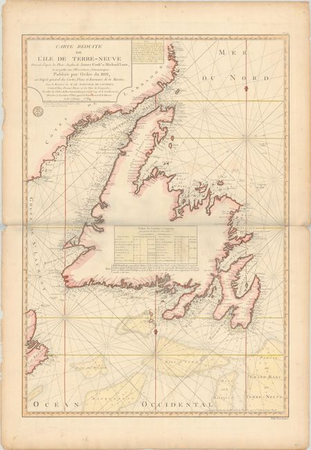
Auction 203, Lot 77
Subject: Newfoundland, Canada
Depot de la Marine
Carte Reduite de l'Ile de Terre-Neuve Dressee d'Apres les Plans Anglois de James Cook et Michael Lane..., 1784
Size: 23.8 x 34.2 inches (60.5 x 86.9 cm)
Estimate: $375 - $450
Sold for: $275
Closed on 4/23/2025
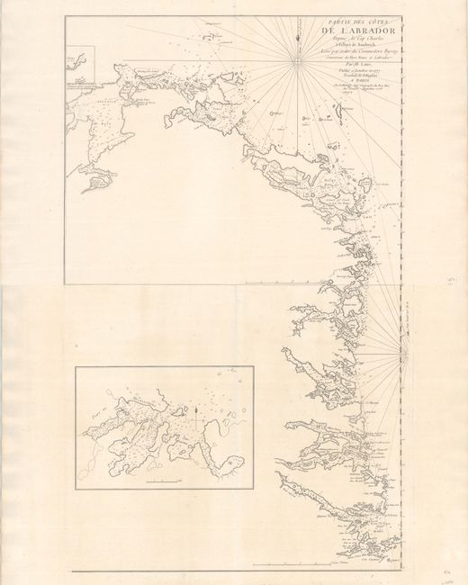
Auction 203, Lot 78
Subject: Labrador, Canada
Le Rouge, George Louis
[On 2 Sheets] Partie des Cotes de Labrador Depuis le Cap Charles a la Baye de Sandwich. Leve par Ordre du Commodore Byron..., 1777
Size: 21.3 x 17 inches (54.1 x 43.2 cm)
Estimate: $550 - $700
Sold for: $200
Closed on 4/23/2025
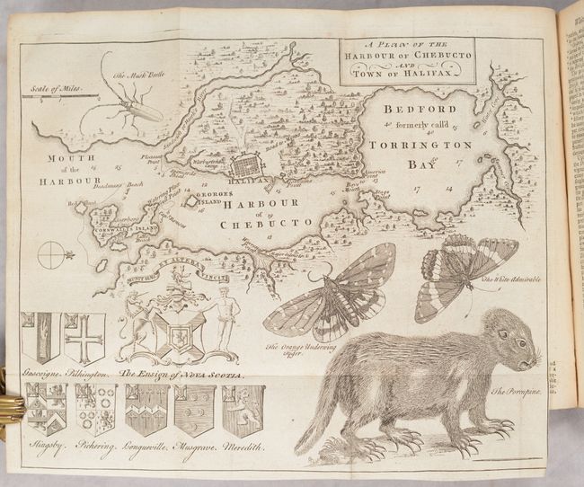
Auction 203, Lot 79
Subject: Halifax, Nova Scotia, Canada
[Map in Book] A Plan of the Harbour of Chebucto and Town of Halifax [in] The Gentleman's Magazine, and Historical Chronicle. Volume XX. For the Year M.DCC.L, 1750
Size: 10.8 x 8.7 inches (27.4 x 22.1 cm)
Estimate: $700 - $850
Unsold
Closed on 4/23/2025

Auction 203, Lot 80
Subject: Eastern Canada, Hudson Bay
Bellin, Jacques Nicolas
Carta della Baja di Hudson, 1781
Size: 11.9 x 8.6 inches (30.2 x 21.8 cm)
Estimate: $90 - $110
Sold for: $65
Closed on 4/23/2025
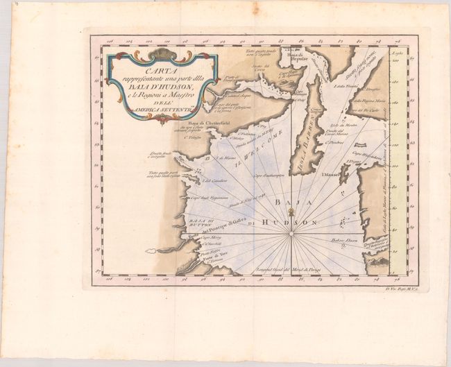
Auction 203, Lot 81
Subject: Hudson Bay, Canada
Rossi, Veremondo
Carta Rappresentante una Parte dlla Baja d'Hudson, e le Region a Maestro dell' America Settentrle, 1763
Size: 10.7 x 8.3 inches (27.2 x 21.1 cm)
Estimate: $110 - $140
Unsold
Closed on 4/23/2025
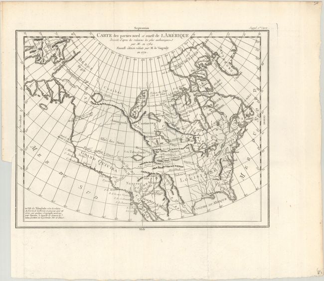
Auction 203, Lot 82
Subject: Colonial United States & Canada
Robert de Vaugondy, Didier
Carte des Parties Nord et Ouest de l Amerique Dresse d'Apres les Relations les Plus Authentiques par M... en 1764..., 1772
Size: 15 x 11.6 inches (38.1 x 29.5 cm)
Estimate: $200 - $230
Sold for: $100
Closed on 4/23/2025
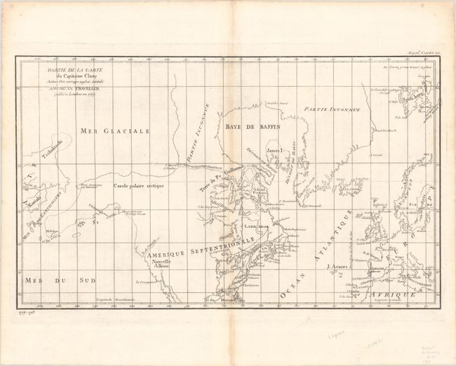
Auction 203, Lot 83
Subject: Colonial United States & Canada, Arctic
Robert de Vaugondy, Didier
Partie de la Carte du Capitaine Cluny Auteur d'un Ouvrage Anglois Intitule American Traveller, 1773
Size: 19.1 x 11.4 inches (48.5 x 29 cm)
Estimate: $80 - $100
Sold for: $60
Closed on 4/23/2025
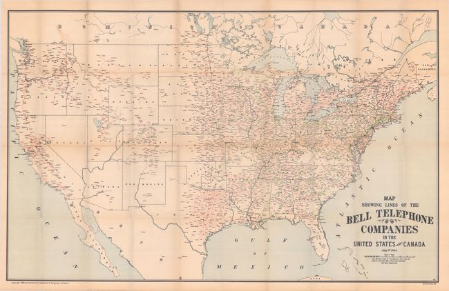
Auction 203, Lot 84
Subject: United States & Canada
Map Showing Lines of the Bell Telephone Companies in the United States and Canada, 1905
Size: 39.3 x 25.1 inches (99.8 x 63.8 cm)
Estimate: $500 - $650
Rare AT&T Map Showing Phone Lines in the Early Days of the 20th Century
Unsold
Closed on 4/23/2025
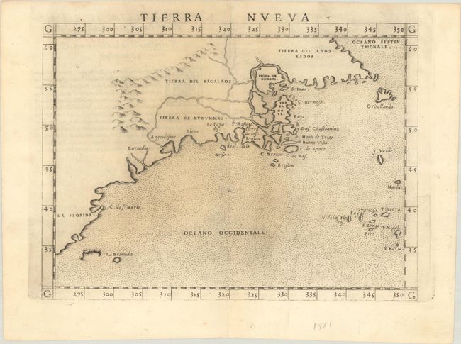
Auction 203, Lot 85
Subject: Eastern United States & Canada
Ruscelli, Girolamo
Tierra Nueva, 1562
Size: 9.7 x 7.2 inches (24.6 x 18.3 cm)
Estimate: $1,000 - $1,300
First State of Ruscelli's Map of the East Coast
Sold for: $750
Closed on 4/23/2025
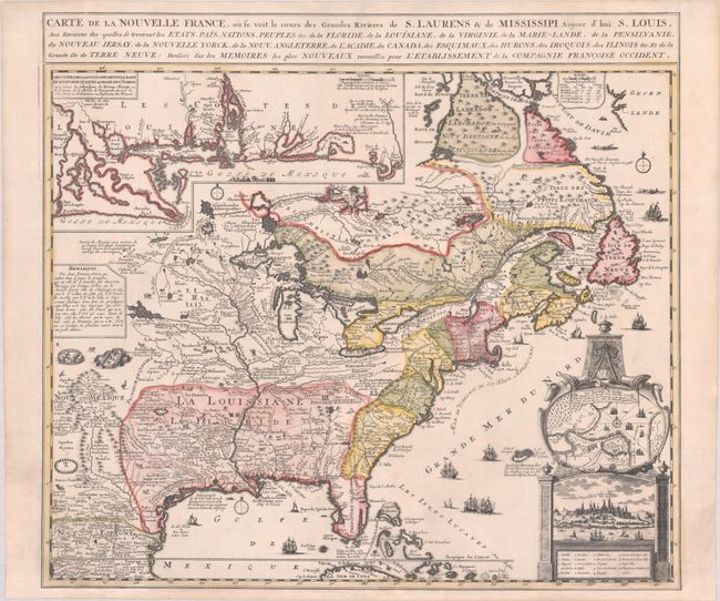
Auction 203, Lot 86
Subject: Colonial Eastern United States & Canada
Fer, Nicolas de
Carte de la Nouvelle France, ou se Voit le Cours des Grandes Rivieres de S. Laurens & de Mississipi Aujour d'hui S. Louis, aux Environs des-quelles se Trouvent les Etats, Pais, Nations, Peuples, &c. de la Floride, de la Louisiane, de la Virginie..., 1720
Size: 21.9 x 19.8 inches (55.6 x 50.3 cm)
Estimate: $2,750 - $3,500
Striking Map of French Colonial Possessions
Sold for: $2,200
Closed on 4/23/2025
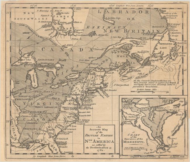
Auction 203, Lot 87
Subject: Colonial Eastern United States & Canada
Gibson, John
An Accurate Map of the British Empire in Nth. America as Settled by the Preliminaries in 1762, 1762
Size: 9.7 x 8.3 inches (24.6 x 21.1 cm)
Estimate: $275 - $350
Sold for: $210
Closed on 4/23/2025
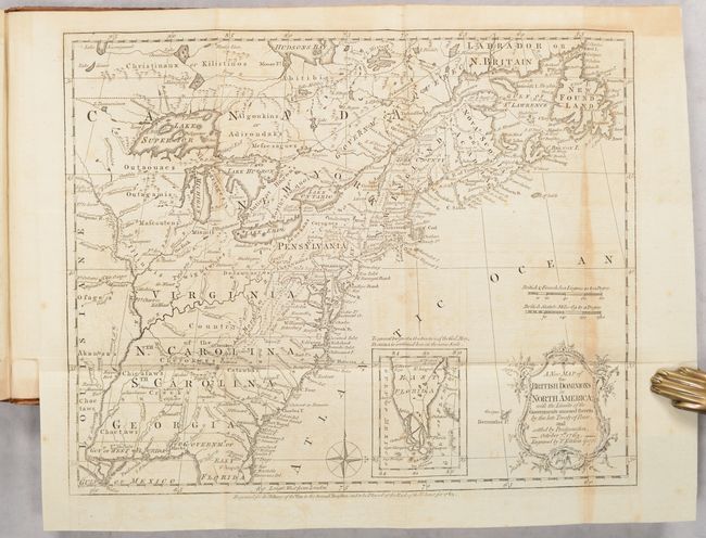
Auction 203, Lot 88
Subject: Colonial Eastern United States & Canada, History Book
Kitchin, Thomas
[Maps in Book] A New Map of the British Dominions in North America; with the Limits of the Governments Annexed Thereto by the Late Treaty of Peace... [bound in] The Annual Register, or a View of the History, Politicks, and Literature…, 1776
Size: 11.9 x 9.6 inches (30.2 x 24.4 cm)
Estimate: $600 - $750
Sold for: $450
Closed on 4/23/2025
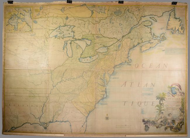
Auction 203, Lot 89
Subject: Colonial Eastern United States & Canada
Mitchell/Le Rouge
Amerique Septentrionale avec les Routes, Distances en Miles, Villages et Etablissements Francois et Anglois par le Docteur Mitchel, 1777
Size: 75 x 52.4 inches (190.5 x 133.1 cm)
Estimate: $9,500 - $12,000
Third French Edition of Mitchell's Monumental Map
Sold for: $5,000
Closed on 4/23/2025
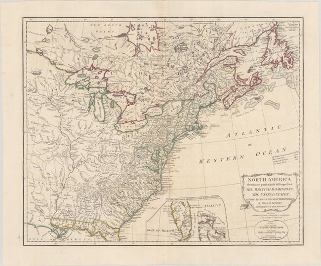
Auction 203, Lot 90
Subject: Eastern United States & Canada
Kitchin, Thomas
North America Wherein Are Particularly Distinguished the British Dominions, the United States, and the Adjacent Spanish Territories, 1794
Size: 21.4 x 17.4 inches (54.4 x 44.2 cm)
Estimate: $1,400 - $1,700
Sold for: $1,000
Closed on 4/23/2025
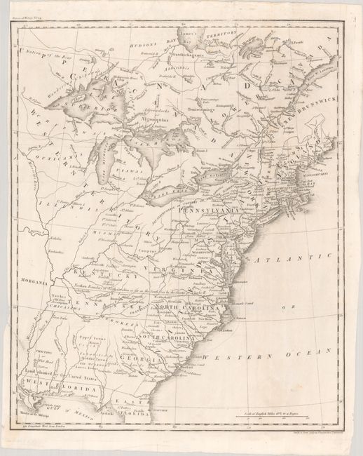
Auction 203, Lot 91
Subject: Eastern United States & Canada, Franklin
[Untitled - Map of the United States, Canada the River St. Lawrence, the Lakes &c.], 1804
Size: 13.1 x 16 inches (33.3 x 40.6 cm)
Estimate: $1,000 - $1,300
Features the Short-Lived Franklinia and Morgania
Sold for: $750
Closed on 4/23/2025
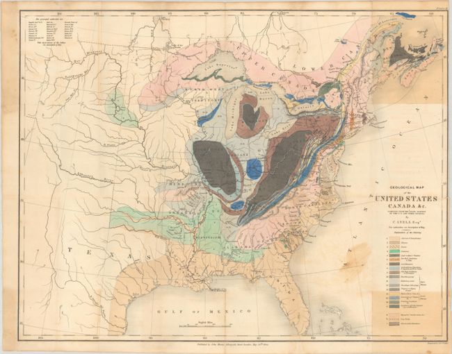
Auction 203, Lot 92
Subject: Eastern United States & Canada, Geology
Lyell, Charles
Geological Map of the United States Canada &c. Compiled from the State Surveys of the U.S. and Other Sources, 1845
Size: 19.8 x 15.3 inches (50.3 x 38.9 cm)
Estimate: $600 - $750
Unsold
Closed on 4/23/2025
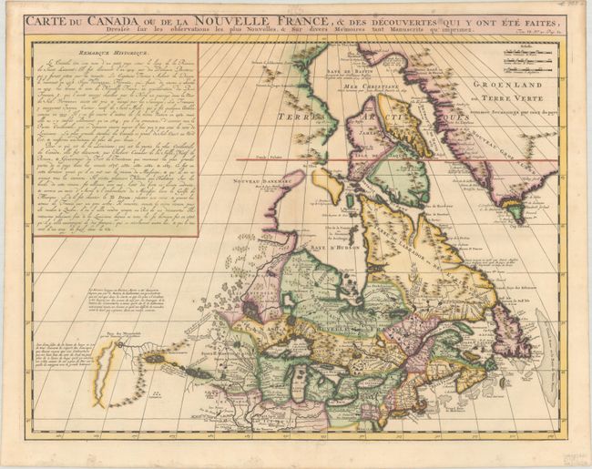
Auction 203, Lot 93
Subject: Colonial Northeastern United States & Canada
Chatelain, Henry Abraham
Carte du Canada ou de la Nouvelle France, & des Decouvertes qui y ont ete Faites, Dressee sur les Observations les Plus Nouvelles, & sur Divers Memoires tant Manuscrits qu' Imprimez, 1719
Size: 20.3 x 15.9 inches (51.6 x 40.4 cm)
Estimate: $600 - $750
Sold for: $400
Closed on 4/23/2025
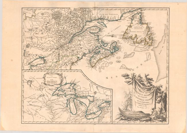
Auction 203, Lot 94
Subject: Colonial Northeastern United States & Canada, Great Lakes
Robert de Vaugondy, Didier
Partie de l'Amerique Septent? qui Comprend la Nouvelle France ou le Canada, 1755
Size: 23.9 x 19 inches (60.7 x 48.3 cm)
Estimate: $400 - $500
Sold for: $200
Closed on 4/23/2025
Auction 203, Lot 95
Subject: Colonial Northeastern United States & Canada
Rhode, Johann Cristoph
Theatrum Belli in America Septentrionali II. Foiliis Comprehensum..., 1755
Size: 31.5 x 22 inches (80 x 55.9 cm)
Estimate: $8,000 - $9,500
Scarce German Map Illustrating the French & Indian War
Sold for: $5,000
Closed on 4/23/2025
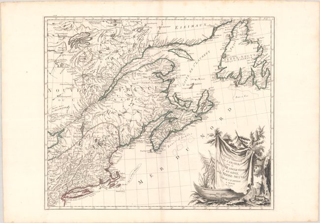
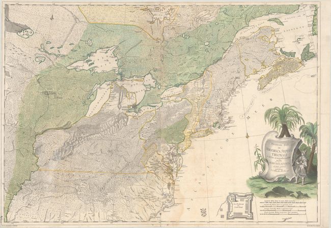
Auction 203, Lot 96
Subject: Colonial Northeastern United States & Canada
D'Anville/Santini
Partie Orientale du Canada, avec la Nouvelle Angleterre l'Acadie, et la Terre-Neuve, 1776
Size: 22.7 x 19.2 inches (57.7 x 48.8 cm)
Estimate: $400 - $475
Sold for: $250
Closed on 4/23/2025
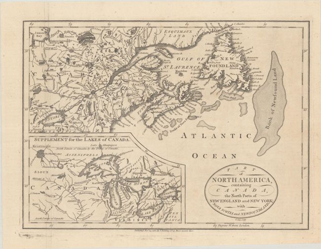
Auction 203, Lot 97
Subject: Colonial Northeastern United States & Canada, Great Lakes
Cary, John
Part of North America, Containing Canada, the North Parts of New England and New York; with Nova Scotia and Newfoundland, 1781
Size: 11.3 x 8.3 inches (28.7 x 21.1 cm)
Estimate: $190 - $220
Sold for: $120
Closed on 4/23/2025
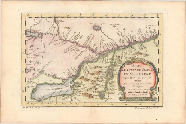
Auction 203, Lot 98
Subject: Colonial Lake Ontario & St. Lawrence River
Bellin, Jacques Nicolas
Suite du Cours du Fleuve de St. Laurent, Depuis Quebec Jusqu au Lac Ontario. Pour Servir a l'Histoire Generale des Voyages, 1757
Size: 11.3 x 7.6 inches (28.7 x 19.3 cm)
Estimate: $110 - $140
Sold for: $110
Closed on 4/23/2025
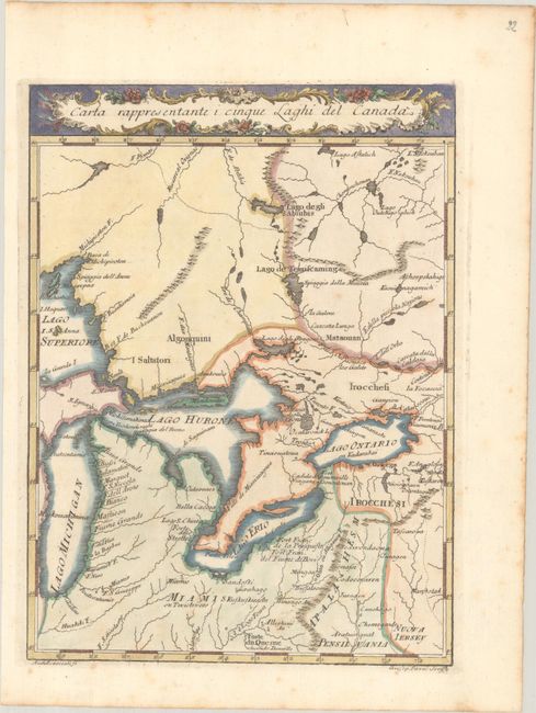
Auction 203, Lot 99
Subject: Colonial Central United States & Canada, Great Lakes
Pazzi, Giuseppe
Carta Rappresentante i Cinque Laghi del Canada, 1763
Size: 7.4 x 10 inches (18.8 x 25.4 cm)
Estimate: $240 - $300
Sold for: $180
Closed on 4/23/2025
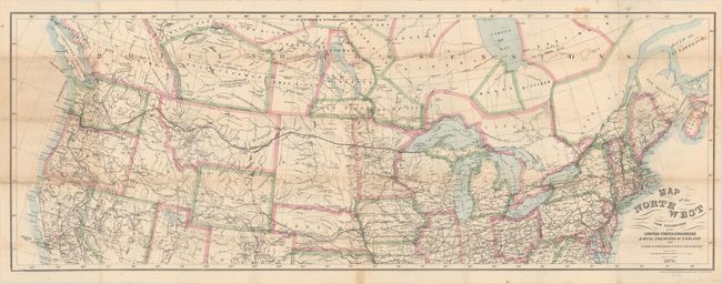
Auction 203, Lot 100
Subject: Northern United States & Canada
Bien, Julius
Map of the Northwest from Explorations by the United States Engineers & Royal Engineers of England and Union & Northern Pacific R.R. Surveys, 1870
Size: 41.2 x 15.2 inches (104.6 x 38.6 cm)
Estimate: $190 - $220
Sold for: $140
Closed on 4/23/2025
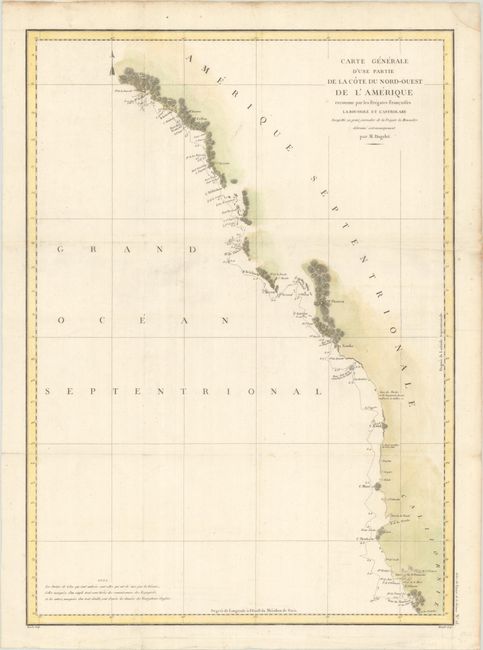
Auction 203, Lot 101
Subject: Western United States & Canada
La Perouse, Comte Jean F. Galoup, de
Carte Generale d'une Partie de la Cote du Nord-Ouest de l'Amerique Reconnue par les Fregates Francaises la Boussole et l'Astrolabe..., 1797
Size: 19.5 x 27.1 inches (49.5 x 68.8 cm)
Estimate: $200 - $230
Sold for: $75
Closed on 4/23/2025
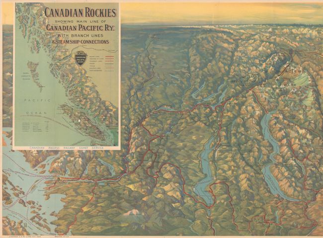
Auction 203, Lot 102
Subject: Western United States & Canada
Railroad Companies, (Various)
Canadian Rockies Showing Main Line of Canadian Pacific Ry. with Branch Lines & Steamship Connections, 1924
Size: 46.5 x 16.8 inches (118.1 x 42.7 cm)
Estimate: $100 - $130
Sold for: $75
Closed on 4/23/2025
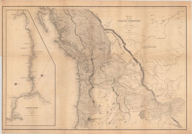
Auction 203, Lot 103
Subject: Northwestern United States & Canada
Wilkes, Charles
Map of the Oregon Territory by the U.S. Ex. Ex., 1841
Size: 34.1 x 22.9 inches (86.6 x 58.2 cm)
Estimate: $1,400 - $1,700
One of the Most Detailed and Important 19th-Century Maps of the American Northwest
Sold for: $1,100
Closed on 4/23/2025
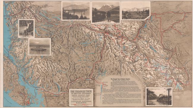
Auction 203, Lot 104
Subject: Northwestern United States & Canada
Railroad Companies, (Various)
The Triangle Tour of British Columbia - Jasper National Park Mount Robson Park Canadian Rockies and the Scenic Seas of the North Pacific Coast [on verso] Alaska and the Yukon, 1929
Size: 29.8 x 16.8 inches (75.7 x 42.7 cm)
Estimate: $150 - $180
NO RESERVE
Unsold
Closed on 4/23/2025
30 lots