Filtered by Category:Canada(Show All Categories)
Showing results for:Auction 174
Catalog Archive
14 lots
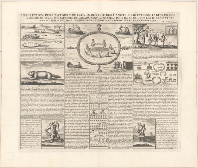
Auction 174, Lot 105
Subject: Canada
Chatelain, Henry Abraham
Description des Castors & de Leur Industrie, des Canots, Habitations, Habillemens, Maniere de Vivre des Sauvages du Canada avec la Maniere dont ils se Marient les Hieroglyphes..., 1720
Size: 16.9 x 14.5 inches (42.9 x 36.8 cm)
Estimate: $160 - $190
Sold for: $140
Closed on 9/11/2019
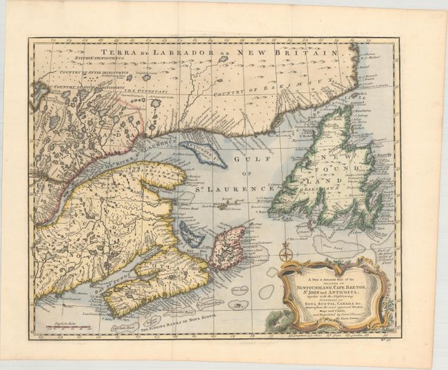
Auction 174, Lot 106
Subject: Eastern Canada
Bowen, Emanuel
A New & Accurate Map of the Islands of Newfoundland, Cape Breton, St. John and Anticosta; Together with the Neighbouring Countries of Nova Scotia, Canada &c..., 1747
Size: 16.8 x 13.6 inches (42.7 x 34.5 cm)
Estimate: $300 - $400
Sold for: $650
Closed on 9/11/2019
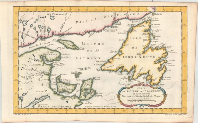
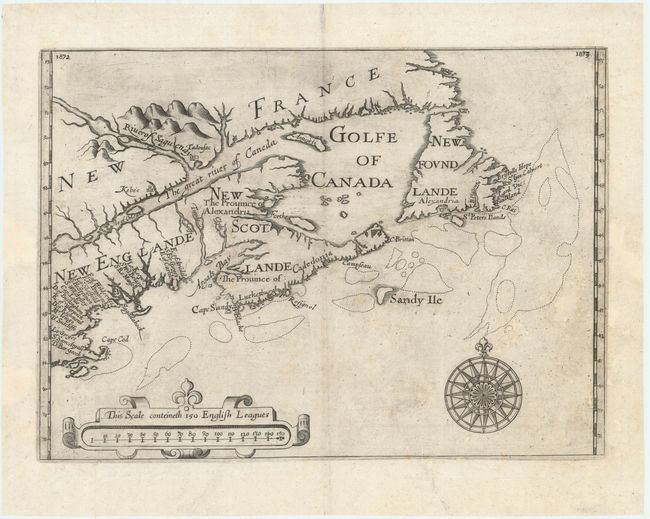
Auction 174, Lot 107
Subject: Eastern Canada
Bellin, Jacques Nicolas
Carte du Golphe de St. Laurent et Pays Voisins pour Servir a l'Histoire Generale des Voyages, 1780
Size: 14.3 x 8.8 inches (36.3 x 22.4 cm)
Estimate: $100 - $130
Sold for: $75
Closed on 9/11/2019
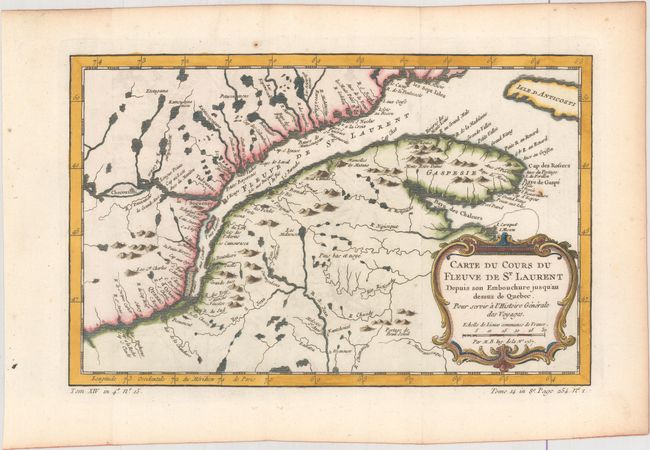
Auction 174, Lot 108
Subject: St. Lawrence River, Canada
Bellin, Jacques Nicolas
[Lot of 2] Carte du Cours du Fleuve de St. Laurent Depuis son Embouchure Jusqu'au Dessus de Quebec. Pour Servir a l'Histoire Generale des Voyages [and] Suite du Cours du Fleuve de St. Laurent, Depuis Quebec Jusqu au Lac Ontario, 1757
Size: 11.9 x 7.5 inches (30.2 x 19.1 cm)
Estimate: $160 - $190
Sold for: $170
Closed on 9/11/2019
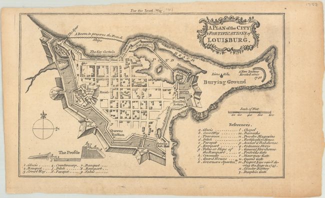
Auction 174, Lot 109
Subject: Cape Breton Island, Canada
Anon.
A Plan of the City & Fortifications of Louisburg, 1758
Size: 7.1 x 4.4 inches (18 x 11.2 cm)
Estimate: $60 - $80
NO RESERVE
Sold for: $36
Closed on 9/11/2019
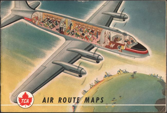
Auction 174, Lot 110
Subject: United States & Canada, Flight Maps
[Lot of 3] TCA Air Route Maps [and] Trans-Canada Air Lines Air Canada [and] Route Map Vancouver to Amsterdam, 1950-60
Size: See Description
Estimate: $80 - $100
Sold for: $40
Closed on 9/11/2019
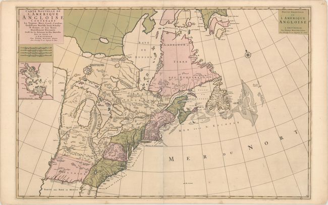
Auction 174, Lot 111
Subject: Colonial Eastern United States & Canada
Mortier, Pierre
Carte Nouvelle de l'Amerique Angloise Contenant la Virginie, Mary-Land, Caroline, Pensylvania Nouvelle Iorck. N: Iarsey N: France, et les Terres Nouvellement Decouerte..., 1700
Size: 35.9 x 23.5 inches (91.2 x 59.7 cm)
Estimate: $2,200 - $2,500
A Map Showing Fascinating Geographic Misconceptions in Colonial America
Sold for: $1,200
Closed on 9/11/2019
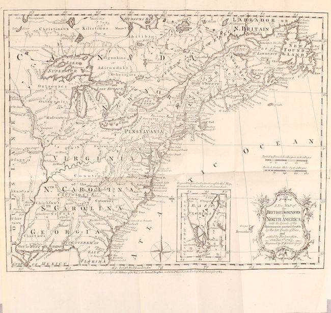
Auction 174, Lot 112
Subject: Colonial Eastern United States & Canada
Kitchin, Thomas
[Maps in Book] A New Map of the British Dominions in North America; with the Limits of the Governments Annexed Thereto by the Late Treaty of Peace... [bound in] The Annual Register, or a View of the History, Politicks, and Literature…, 1765
Size: 11.9 x 9.6 inches (30.2 x 24.4 cm)
Estimate: $650 - $800
Sold for: $550
Closed on 9/11/2019
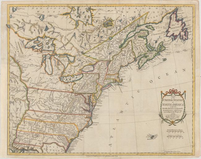
Auction 174, Lot 113
Subject: Eastern United States & Canada
Kitchin, Thomas
Map of the United States in North America: with the British, French and Spanish Dominions Adjoining, According to the Treaty of 1783, 1783
Size: 19.9 x 16.1 inches (50.5 x 40.9 cm)
Estimate: $1,400 - $1,700
One of the Earliest English-Produced Maps to Acknowledge the United States
Sold for: $1,400
Closed on 9/11/2019
Auction 174, Lot 114
Subject: Colonial Northeastern United States & Canada
Alexander, William (Sir)
[Untitled - Northeastern United States & Canada], 1625
Size: 13.5 x 9.8 inches (34.3 x 24.9 cm)
Estimate: $5,500 - $7,000
The First Map to Name New Scotland
Sold for: $4,000
Closed on 9/11/2019
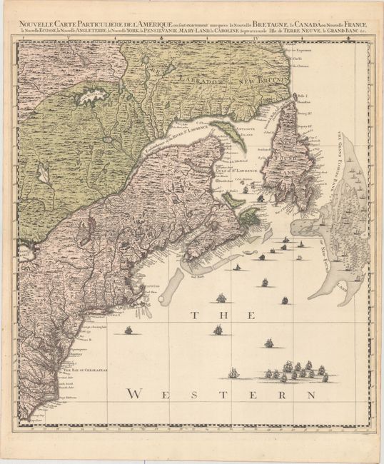
Auction 174, Lot 115
Subject: Colonial Northeastern United States & Canada
Popple/Covens & Mortier
Nouvelle Carte Particuliere de l'Amerique ou sont Exactement Marquees la Nouvelle Bretagne, le Canada ou Nouvelle France, la Nouvelle Ecosse, la Nouvelle Angleterre, la Nouvelle York, la Pensilvanie, Mary-Land, la Caroline Septentrionale..., 1741
Size: 20.7 x 22.5 inches (52.6 x 57.2 cm)
Estimate: $2,200 - $2,500
The Northeastern Sheet of the Reduced-Size Edition of Popple's Map
Sold for: $1,600
Closed on 9/11/2019
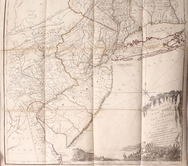
Auction 174, Lot 116
Subject: Colonial Northeastern United States & Quebec
Holland/Pownal
The Provinces of New York, and New Jersey; with Part of Pensilvania, and the Province of Quebec..., 1776
Size: 21.5 x 53.3 inches (54.6 x 135.4 cm)
Estimate: $4,000 - $4,750
Thomas Jefferys' Important Revolutionary War Period Map
Sold for: $2,500
Closed on 9/11/2019
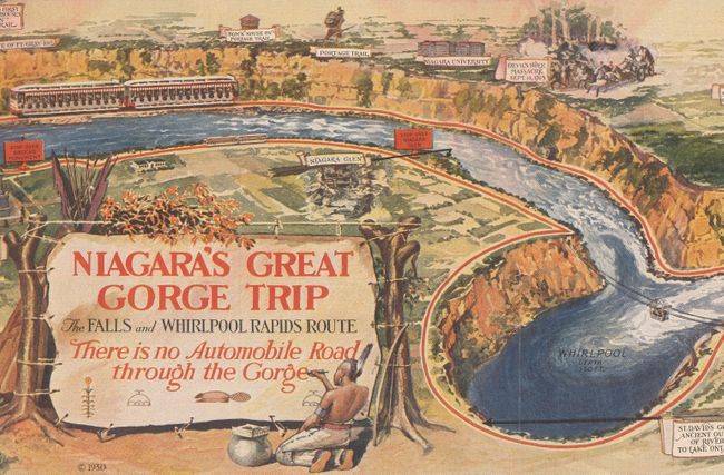
Auction 174, Lot 117
Subject: Niagara Falls, New York, Canada
Niagara's Great Gorge Trip - The Falls and Whirlpool Rapids Route, 1930
Size: 31.3 x 7.6 inches (79.5 x 19.3 cm)
Estimate: $60 - $80
NO RESERVE
Sold for: $85
Closed on 9/11/2019
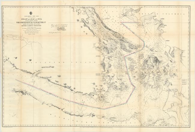
Auction 174, Lot 118
Subject: Washington, British Columbia
U.S. Hydrographic Office
Strait of Juan de Fuca and the Channels Between the Continent & Vancouver Id. Showing the Boundary Line Between British & American Possessions, 1872
Size: 44.2 x 28.8 inches (112.3 x 73.2 cm)
Estimate: $375 - $450
Sold for: $650
Closed on 9/11/2019
14 lots