Filtered by Category:North America(Show All Categories)
Showing results for:Auction 174
Catalog Archive
18 lots
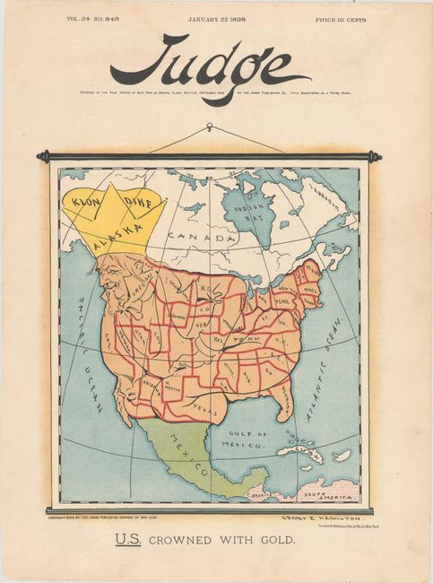
Auction 174, Lot 57
Subject: Cartographic Miscellany, North America
Judge Company
U.S. Crowned with Gold, 1898
Size: 7.9 x 8.9 inches (20.1 x 22.6 cm)
Estimate: $110 - $140
Sold for: $230
Closed on 9/11/2019
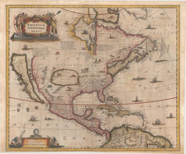
Auction 174, Lot 88
Subject: Colonial North America
Hondius/Jansson
America Septentrionalis, 1647
Size: 21.8 x 18.3 inches (55.4 x 46.5 cm)
Estimate: $1,600 - $1,900
One of the Most Important Maps Perpetuating the Myth of the Island of California
Sold for: $2,750
Closed on 9/11/2019
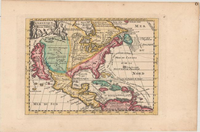
Auction 174, Lot 89
Subject: Colonial North America
La Feuille, Daniel de
L'Amerique Septentrionale / Noord America, 1706
Size: 7.4 x 5.4 inches (18.8 x 13.7 cm)
Estimate: $350 - $425
Sold for: $250
Closed on 9/11/2019
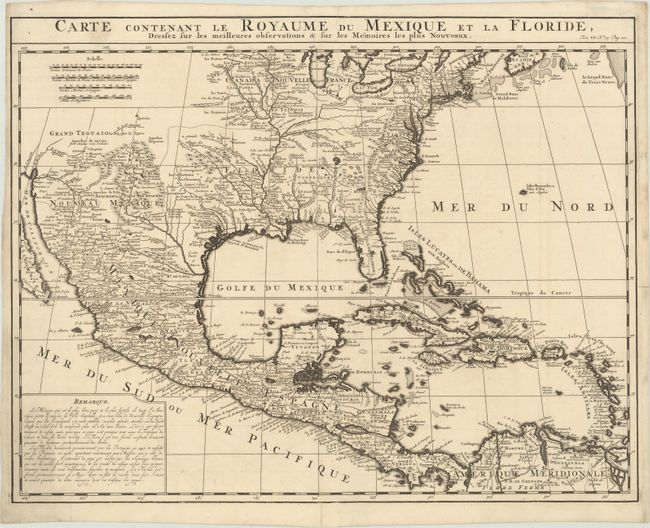
Auction 174, Lot 90
Subject: Colonial North America
Chatelain, Henry Abraham
Carte Contenant le Royaume du Mexique et la Floride, Dressez sur les Meilleures Observations & sur les Memoires les Plus Nouveaux, 1719
Size: 20.4 x 15.9 inches (51.8 x 40.4 cm)
Estimate: $700 - $850
Sold for: $500
Closed on 9/11/2019
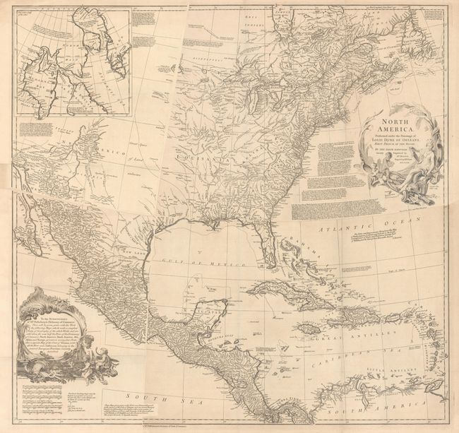
Auction 174, Lot 91
Subject: Colonial North America
Bolton, Solomon
[4 Sheets] North America. Performed Under the Patronage of Louis Duke of Orleans, First Prince of the Blood; by the Sieur d'Anville..., 1752
Size: 34 x 32.5 inches (86.4 x 82.6 cm)
Estimate: $1,100 - $1,400
Sold for: $950
Closed on 9/11/2019
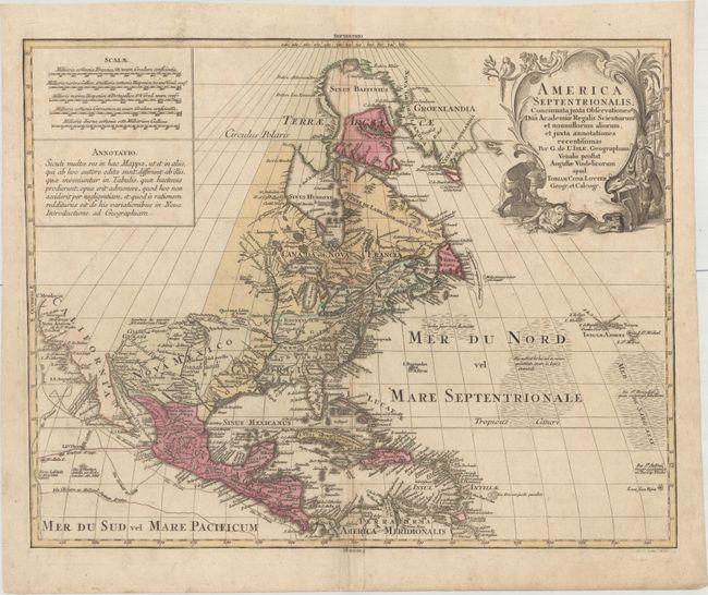
Auction 174, Lot 92
Subject: Colonial North America
Lotter, Tobias Conrad
America Septentrionalis, Concinnata Juxta Observationes Dnn Academiae Regalis Scientiarum et Nonnullorum Aliorum, et Juxta Annotationes Recentissimas per G. de l'Isle..., 1772
Size: 22.6 x 17.8 inches (57.4 x 45.2 cm)
Estimate: $600 - $750
Sold for: $450
Closed on 9/11/2019
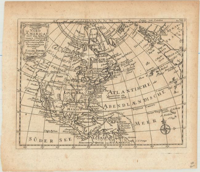
Auction 174, Lot 93
Subject: Colonial North America
Bowen, Emanuel
Eine Richtige Charte von Nord America nach den Besten Neuern Charten Gezeichnet und Durch Astronomische Bemerckungen Berichtiget, 1778
Size: 7.9 x 6.1 inches (20.1 x 15.5 cm)
Estimate: $110 - $140
Sold for: $80
Closed on 9/11/2019
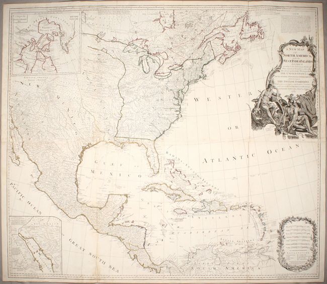
Auction 174, Lot 94
Subject: North America
Sayer, Robert
A New Map of North America, with the West India Islands. Divided According to the Preliminary Articles of Peace, Signed at Versailles, 20, Jan. 1783..., 1786
Size: 45.9 x 39.9 inches (116.6 x 101.3 cm)
Estimate: $2,400 - $3,000
Important Large Map of North America Featuring the Young United States
Sold for: $1,800
Closed on 9/11/2019
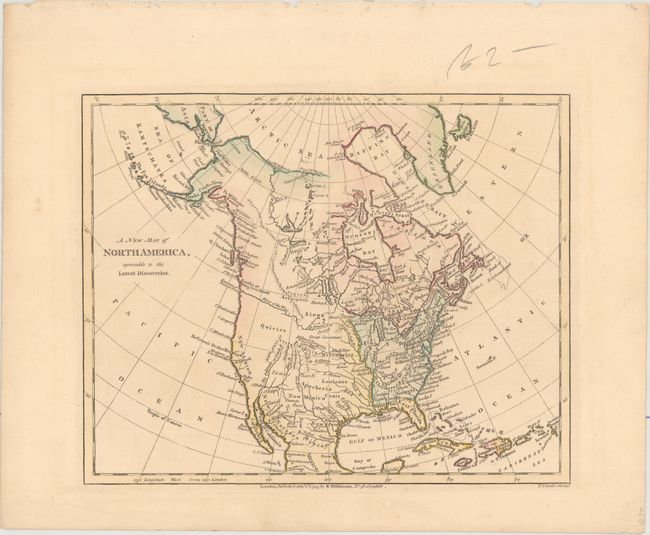
Auction 174, Lot 95
Subject: North America
Wilkinson, Robert
A New Map of North America, Agreeable to the Latest Discoveries, 1794
Size: 10 x 8 inches (25.4 x 20.3 cm)
Estimate: $150 - $180
Sold for: $80
Closed on 9/11/2019
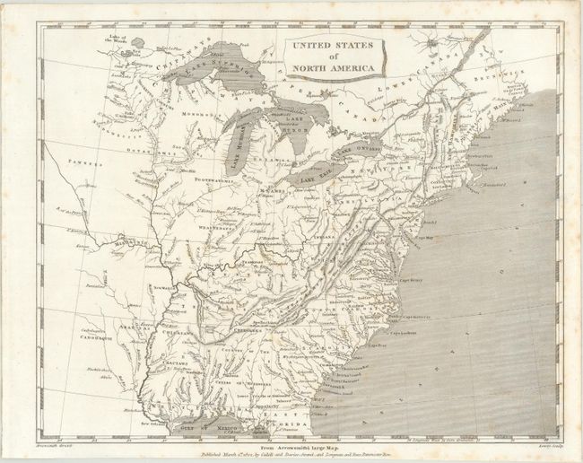
Auction 174, Lot 96
Subject: North America
Arrowsmith, Aaron, Sr.
[Lot of 3] United States of North America [and] British Possessions in America [and] Spanish Dominions in North America, 1802
Size: 9.8 x 7.8 inches (24.9 x 19.8 cm)
Estimate: $200 - $250
Sold for: $170
Closed on 9/11/2019
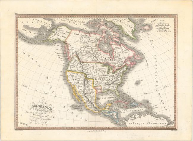
Auction 174, Lot 97
Subject: North America, Texas
Lorrain, N. Pere
Amerique Septentrionale, 1839
Size: 14.9 x 10.6 inches (37.8 x 26.9 cm)
Estimate: $180 - $220
Sold for: $210
Closed on 9/11/2019
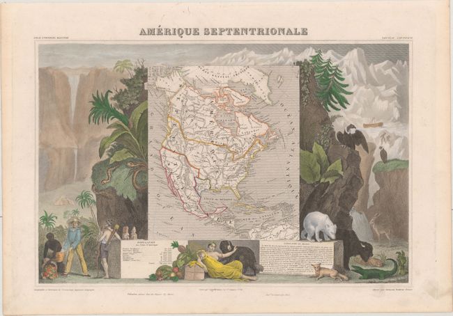
Auction 174, Lot 98
Subject: North America, Texas
Levasseur, Victor
Amerique Septentrionale, 1843
Size: 16.6 x 10.8 inches (42.2 x 27.4 cm)
Estimate: $160 - $190
Sold for: $190
Closed on 9/11/2019
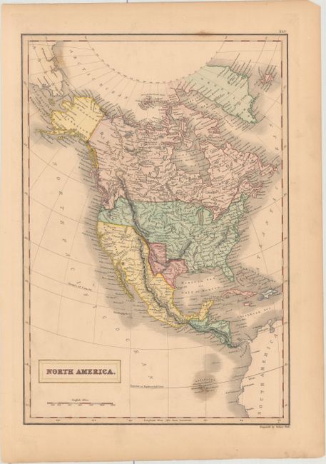
Auction 174, Lot 99
Subject: North America
Hall, Sidney
North America, 1844
Size: 10.2 x 14.9 inches (25.9 x 37.8 cm)
Estimate: $160 - $190
Sold for: $300
Closed on 9/11/2019
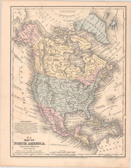
Auction 174, Lot 100
Subject: North America
Mitchell/Young
No. 4 Map of North America Engraved to Illustrate Mitchell's School and Family Geography, 1858
Size: 8.4 x 10.9 inches (21.3 x 27.7 cm)
Estimate: $80 - $100
Sold for: $45
Closed on 9/11/2019
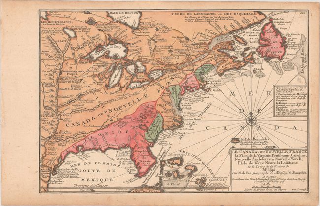
Auction 174, Lot 101
Subject: Colonial Eastern North America & West Indies
Fer, Nicolas de
Le Canada, ou Nouvelle France, la Floride, la Virginie, Pensilvanie, Caroline, Nouvelle Angleterre et Nouvelle Yorck, l'Isle de Terre Neuve, la Louisiane et le Cours de la Riviere de Misisipi, 1705
Size: 13.4 x 9.2 inches (34 x 23.4 cm)
Estimate: $950 - $1,100
Sold for: $700
Closed on 9/11/2019
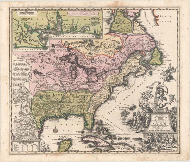
Auction 174, Lot 102
Subject: Colonial Eastern North America & West Indies
Seutter, Matthias
Accurata Delineatio Celeberrimae Regionis Ludovicianae vel Gallice Louisiane ol. Canadae et Floridae ad Poliatione in Septemtrionali America Descriptae quae Hodie Nomine Fluminis Mississippi..., 1730
Size: 22.3 x 19.3 inches (56.6 x 49 cm)
Estimate: $2,750 - $3,500
Map Focusing on the Mississippi River and the "Mississippi Bubble"
Sold for: $1,750
Closed on 9/11/2019
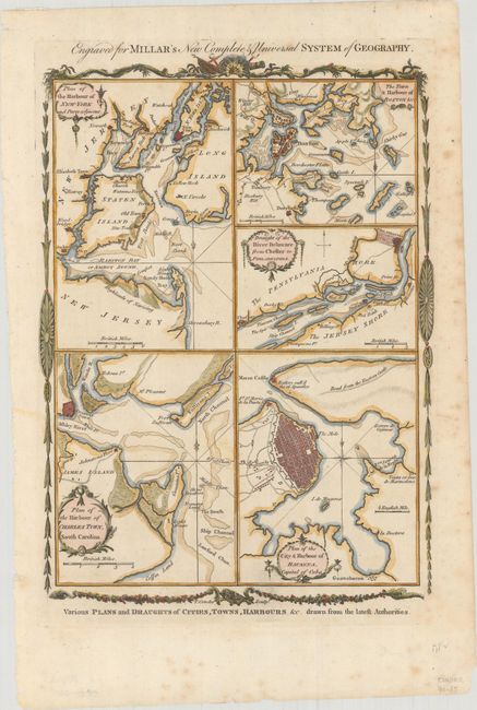
Auction 174, Lot 103
Subject: Colonial Eastern North America & West Indies
Conder, Thomas
Various Plans and Draughts of Cities, Towns, Harbours &c. Drawn from the Latest Authorities, 1780
Size: 8.3 x 11.6 inches (21.1 x 29.5 cm)
Estimate: $350 - $425
Unsold
Closed on 9/11/2019
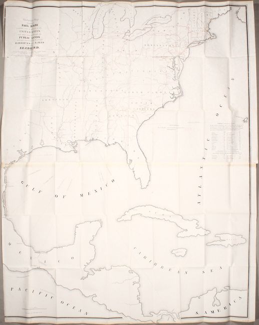
Auction 174, Lot 104
Subject: Eastern North America & West Indies
U.S. Government
Skeleton Map Showing the Rail Roads Completed and in Progress in the United States, and Those Projected Through the Public Lands..., 1849
Size: 36.1 x 46.4 inches (91.7 x 117.9 cm)
Estimate: $200 - $230
Sold for: $100
Closed on 9/11/2019
18 lots