Filtered by Category:Canada(Show All Categories)
Showing results for:Auction 149
Catalog Archive
19 lots
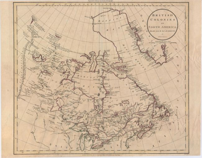
Auction 149, Lot 102
Subject: Canada
Russell, John C.
British Colonies in North America Drawn from the Best Authorities, 1799
Size: 18 x 15.6 inches (45.7 x 39.6 cm)
Estimate: $150 - $180
Sold for: $110
Closed on 5/21/2014
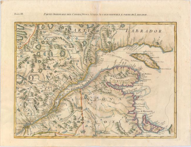
Auction 149, Lot 103
Subject: Eastern Canada
Zatta, Antonio
Parte Orientale del Canada, Nuova Scozia Settentrionale, e Parte di Labrador, 1779
Size: 16.9 x 12.9 inches (42.9 x 32.8 cm)
Estimate: $275 - $350
Unsold
Closed on 5/21/2014
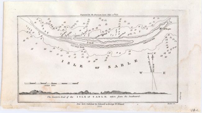
Auction 149, Lot 104
Subject: Isle of Sable, Nova Scotia, Canada
Blunt, Edmund
Isle of Sable, 1833
Size: 7.2 x 3.9 inches (18.3 x 9.9 cm)
Estimate: $70 - $90
Sold for: $50
Closed on 5/21/2014
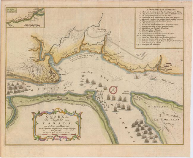
Auction 149, Lot 105
Subject: Quebec City, Canada
Tirion, Isaac
Quebek, de Hoofdstad van Kanada; aan de Rivier van St. Laurens..., 1759
Size: 16.9 x 12.9 inches (42.9 x 32.8 cm)
Estimate: $350 - $425
Unsold
Closed on 5/21/2014
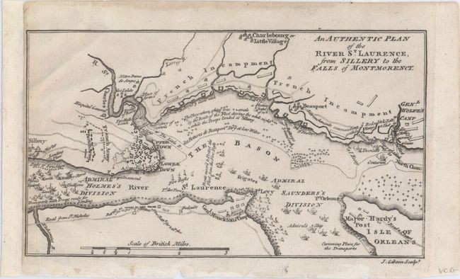
Auction 149, Lot 106
Subject: Quebec City, Canada
Gibson, John
An Authentic Plan of the River St. Laurence, from Sillery to the Falls of Montmorency, 1759
Size: 7.4 x 4.3 inches (18.8 x 10.9 cm)
Estimate: $140 - $180
Sold for: $75
Closed on 5/21/2014
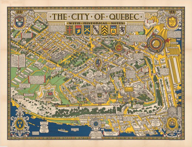
Auction 149, Lot 107
Subject: Quebec City, Canada
The City of Quebec with Historical Notes, 1932
Size: 33.4 x 25.1 inches (84.8 x 63.8 cm)
Estimate: $200 - $250
Sold for: $150
Closed on 5/21/2014
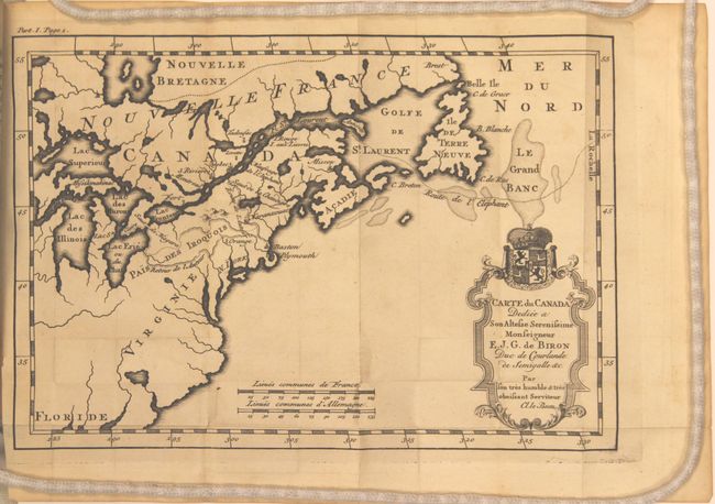
Auction 149, Lot 108
Subject: Colonial United States & Canada
Le Beau, Claude
Carte du Canada Dediee a Son Altesse Serenissime Monseigneur [in book] Avantures du Sr. C. le Beau…, 1738
Size: 4 x 6.3 inches (10.2 x 16 cm)
Estimate: $900 - $1,100
Sold for: $450
Closed on 5/21/2014
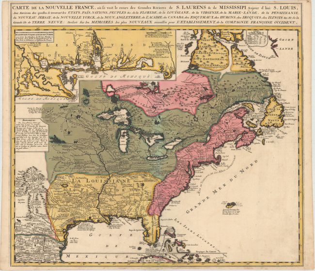
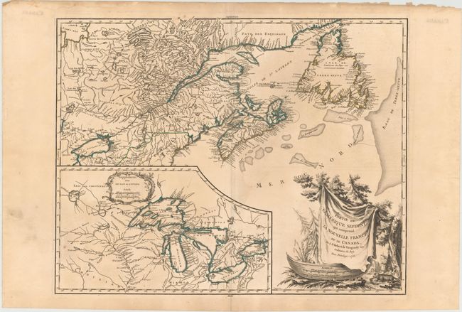
Auction 149, Lot 109
Subject: Colonial United States & Canada
Ottens/De Fer
Carte de la Nouvelle France, ou se Voit le Cours des Grandes Rivieres de S. Laurens & de Mississipi Aujour d'hui S. Louis..., 1745
Size: 21.6 x 19.5 inches (54.9 x 49.5 cm)
Estimate: $2,300 - $2,600
Reduced Version of De Fer's Influential Map of French Possessions in North America
Sold for: $1,700
Closed on 5/21/2014
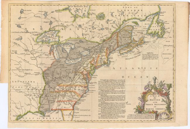
Auction 149, Lot 110
Subject: Colonial United States & Canada
Lodge, John
A Map of the British and French Settlements in North America, 1755
Size: 15.3 x 11 inches (38.9 x 27.9 cm)
Estimate: $450 - $550
Sold for: $550
Closed on 5/21/2014
Auction 149, Lot 111
Subject: Colonial Eastern United States & Canada, Great Lakes
Robert de Vaugondy, Didier
Partie de l'Amerique Septent? qui Comprend la Nouvelle France ou le Canada, 1755
Size: 23.8 x 18.8 inches (60.5 x 47.8 cm)
Estimate: $700 - $850
Unsold
Closed on 5/21/2014
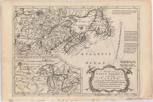
Auction 149, Lot 112
Subject: Colonial United States & Canada, Great Lakes
Barrow, John (Sir)
Part of North America; Containing Canada, the North Parts of New England and New York; with Nova Scotia and Newfound Land. From Sr. Robert with Improvements, 1759
Size: 11.5 x 8.1 inches (29.2 x 20.6 cm)
Estimate: $140 - $180
Sold for: $275
Closed on 5/21/2014
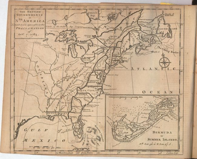
Auction 149, Lot 113
Subject: Colonial United States & Canada
Gibson, John
[Lot of 2] The British Governments in Nth. America Laid Down Agreeable to the Proclamation of Octr. 7, 1763 [and] [October and December 1763 Issues of Gentleman's Magazine], 1763
Size: 9.3 x 8 inches (23.6 x 20.3 cm)
Estimate: $275 - $375
Sold for: $240
Closed on 5/21/2014
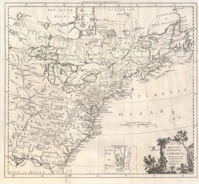
Auction 149, Lot 114
Subject: Colonial United States & Canada
Kitchin, Thomas
British Dominions in America, Drawn from the Latest and Best Authorities, 1770
Size: 14.8 x 13.4 inches (37.6 x 34 cm)
Estimate: $600 - $800
Sold for: $450
Closed on 5/21/2014
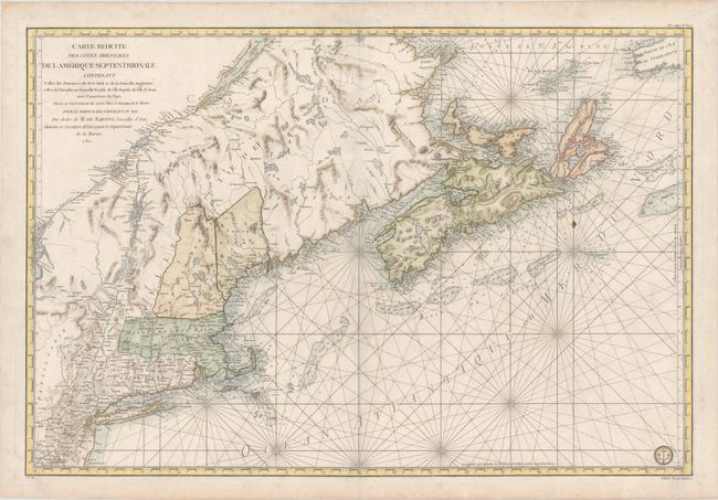
Auction 149, Lot 115
Subject: Colonial United States & Canada
Sartine
Carte Reduite des Cotes Orientales de l'Amerique Septentrionale. Contenant Celles des Provinces de New-York et de la Nouveau Angleterre, Celles de l'Acadie ou Nouvelle Ecosse..., 1780
Size: 33.8 x 22.9 inches (85.9 x 58.2 cm)
Estimate: $1,500 - $1,800
Unsold
Closed on 5/21/2014
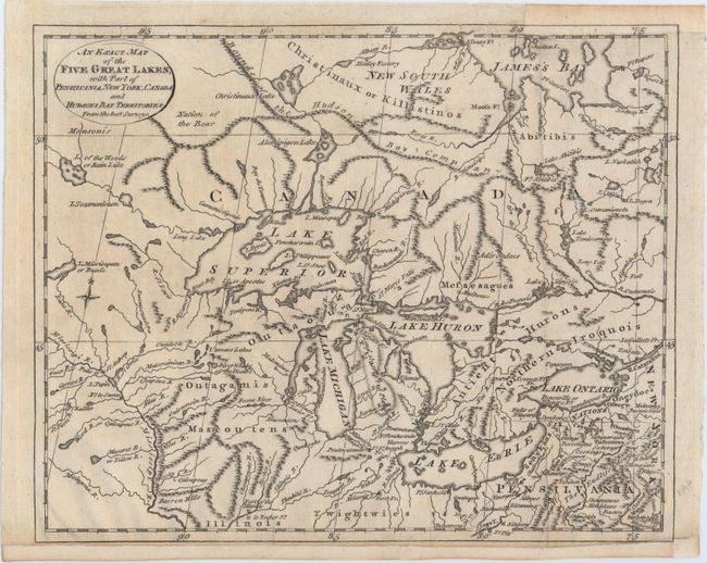
Auction 149, Lot 116
Subject: Colonial Great Lakes, Canada
Lodge, J.
An Exact Map of the Five Great Lakes, with Part of Pensilvania, New York, Canada and Hudsons Bay Territories. From the Best Surveys, 1778
Size: 10.1 x 8.2 inches (25.7 x 20.8 cm)
Estimate: $250 - $350
Sold for: $180
Closed on 5/21/2014
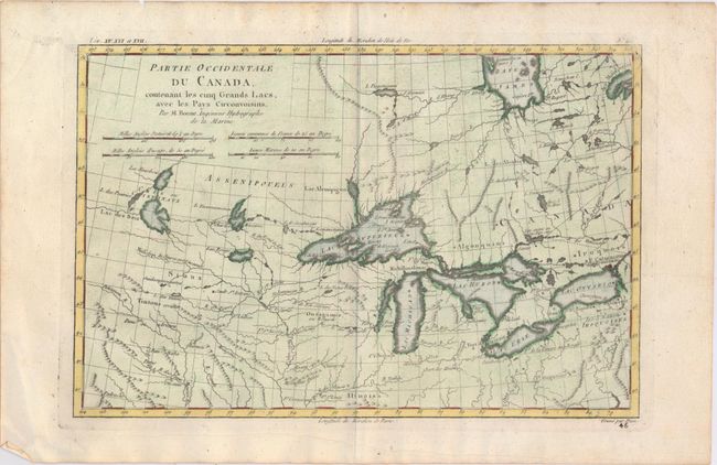
Auction 149, Lot 117
Subject: Colonial United States & Canada, Great Lakes
Bonne/Raynal
Partie Occidentale du Canada Contenant les Cinq Grands Lacs, avec les Pays Circonvoisins, 1780
Size: 12.4 x 8.2 inches (31.5 x 20.8 cm)
Estimate: $250 - $325
Sold for: $240
Closed on 5/21/2014
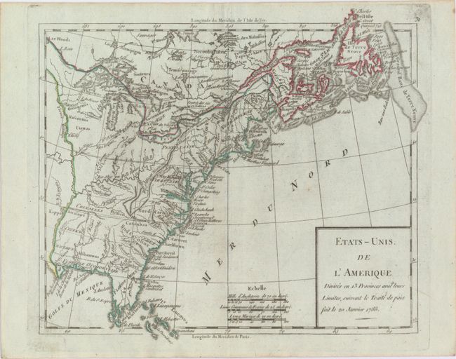
Auction 149, Lot 118
Subject: Eastern United States & Canada
Robert de Vaugondy
Etats-Unis de l'Amerique Divises en 13 Provinces avec Leurs Limites, Suivant le Traite de Paix fait le 20 Janvier 1783, 1785
Size: 9.3 x 8.1 inches (23.6 x 20.6 cm)
Estimate: $160 - $190
Sold for: $140
Closed on 5/21/2014
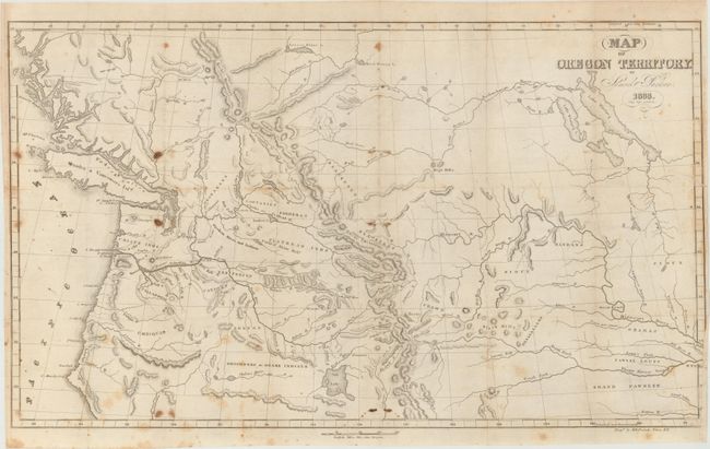
Auction 149, Lot 119
Subject: Northwestern United States, Canada
Parker, Samuel (Rev.)
Map of Oregon Territory, 1838
Size: 22.3 x 14 inches (56.6 x 35.6 cm)
Estimate: $275 - $350
Sold for: $250
Closed on 5/21/2014
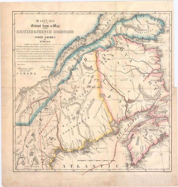
Auction 149, Lot 120
Subject: Canada & Maine
Mr. Jay's Map. Extract from a Map of the British & French Dominions in North America [with book] A Memoir on the North-Eastern Boundary…, 1843
Size: 12.8 x 13.3 inches (32.5 x 33.8 cm)
Estimate: $200 - $250
Sold for: $160
Closed on 5/21/2014
19 lots