Current Auction
Mammoth Plan of Paris
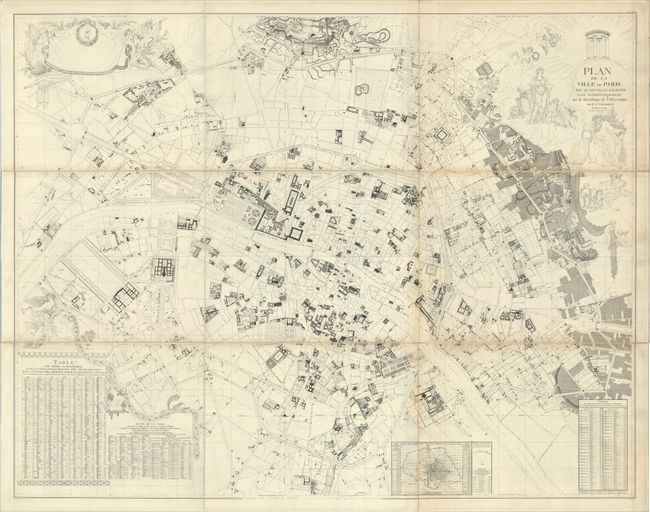
"Plan de la Ville de Paris avec sa Nouvelle Enceinte Leve Geometriquement sur la Meridienne de l'Observatoire"


Subject: Paris, France
Period: 1791 (dated)
Publication:
Color: Black & White
Size:
71 x 55.5 inches
180.3 x 141 cm
Download High Resolution Image
(or just click on image to launch the Zoom viewer)
(or just click on image to launch the Zoom viewer)
This mammoth plan of Paris measures nearly 6 feet wide and was drawn by A.J. Mathieu, engraved by P.T. Bartholome, and published by Edme Verniquet. Issued near the beginning of the French Revolution, it shows the development of the city in precise detail including palaces, hospitals, churches, hotels, government buildings and boulevards. Parks, gardens, fields and open spaces are also well rendered. At bottom is an inset map showing a multitude of trigonometric measurements throughout the city. The bottom corners are composed of a location index and distance table between principal monuments. Enhancing the map are several classical decorative elements including a title cartouche featuring Hera and Poseidon, a blank banner-style dedication cartouche held aloft by cherubs, and Fame sitting atop the location index. Dissected and backed with linen. Marked plate XXXI in the top right corner and published as part of the Atlas National de la Ville de Paris. Title label on verso is dated 1798. Housed in a modern marbled paper portfolio.
References:
Condition: B+
A crisp impression with some light toning along a couple of folds, a few faint spots, and some minor printer's ink residue. Dissected and backed with linen. The first image is a composite image; due to map's size, it was scanned in three parts. See subsequent images for high resolution scans of the map's sections.
Estimate: $700 - $850
Current High Bid:
$0
Reserve: Reserve Not Met
Next Bid: $350
Bid Increments
$250 - $499$25
$500 - $999$50
$1,000 - $2,499$100
$2,500 - $4,999$250
Terms & Conditions