Current Auction
One of the Earliest Maps of the Revolutionary War
"Thirty-Miles Round Boston", Bell, Andrew
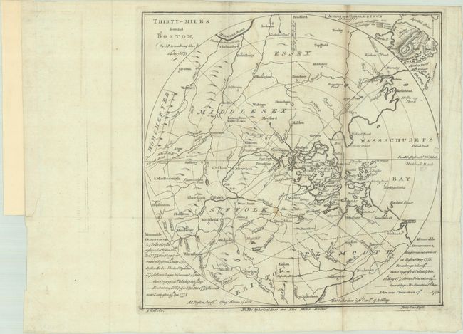
Subject: Boston, Massachusetts
Period: 1775 (dated)
Publication: Scots Magazine
Color: Black & White
Size:
10.2 x 10 inches
25.9 x 25.4 cm
Download High Resolution Image
(or just click on image to launch the Zoom viewer)
(or just click on image to launch the Zoom viewer)
This rare map of Boston by Mostyn John Armstrong was issued at the onset of the Revolutionary War. It was published in the August 1775 issue of Scots Magazine, two months after the Battle of Bunker Hill that initiated the American Revolution. In the same month this map was published, King George III declared that the colonies were in a state of rebellion. George's "Proclamation of Rebellion" required officials of the British Empire "to use their utmost endeavours to withstand and suppress such rebellion" and encouraged subjects of the crown to report any "traitorous correspondence."
Cartographically, the map extends from Worcester to Massachusetts Bay and from Essex south to Plymouth, with concentric circles radiating out from Boston in 5-mile intervals. In addition to place names, rivers and lakes, the map shows four roads extending out from Boston. These routes were critical for troop movements and the spread of intelligence during the war. In the top right corner is an inset showing troop positions at the Battle of Bunker Hill on June 17, 1775 and notations for British "troops landing" on the southern end of Charleston and the subsequent "Provincials retreating to Cambridge" to the northwest. In the bottom corners are "Memorable Occurrences" including "342 chests of tea destroyed at Boston 16th, December, 1773." Engraved by Andrew Bell.
This map is rare on the market with only a handful of dealer listings and auction results in the last 30 years.
References: Jolly #SCOT-44; Nebenzahl (Battle Plans) #26; Phillips (Maps) p. 150.
Condition: B
Issued folding on watermarked paper with some light offsetting, a small stain at lower center, and a 6.5" narrow sliver running along the right vertical fold that has been replaced in facsimile.
Estimate: $2,000 - $2,300
Current High Bid:
$0
Reserve: Reserve Not Met
Next Bid: $1,000
Bid Increments
$1,000 - $2,499$100
$2,500 - $4,999$250
$5,000 - $9,999$500
$10,000 - $24,999$1,000
Terms & Conditions