Current Auction
"One of the Most Ambitious of the Early Pictorial Maps"
"Map of San Francisco Showing Principal Streets and Places of Interest"
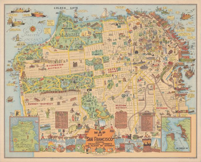
Subject: San Francisco, California
Period: 1927 (dated)
Publication:
Color: Printed Color
Size:
32.4 x 25.9 inches
82.3 x 65.8 cm
Download High Resolution Image
(or just click on image to launch the Zoom viewer)
(or just click on image to launch the Zoom viewer)
This wonderful pictorial map was drawn by Harrison Godwin and printed by Schmidt Lithography in San Francisco. It extends from the Presidio east to the Embarcadero, and south to Sunset, the Mission, and Potrero, with insets of the peninsula at lower left and right. The map is packed full with illustrations of important sites, buildings, parks, and scores of cartoonish characters throughout, including a busy Fisherman’s Wharf, a long line at the Lincoln Park golf course, a beehive of activity in Golden Gate Park, and twins viewing downtown with binoculars on "Twin Peeks." Vignettes along the bottom of the map depict historical events including the discovery of San Francisco Bay by Portola (1769), the city’s first fire (1849), and the infamous earthquake and subsequent fire (1906). Stephen J. Hornsby describes the map as "one of the most ambitious of the early pictorial maps. Godwin’s affectionate depiction of the city is a riot of cartoon characters, buildings, trains and watercraft."
References: Hornsby (Picturing America) plt. 63; Rumsey #8102.
Condition: B+
A colorful example on a sheet with the crossed pickaxe watermarks of "Construction Bond." There are a couple faint spots at left and light extraneous creasing at right. A few short archivally repaired edge tears just enter the borders at left and right and additional tiny repaired edge tears are confined to the top blank margin.
Estimate: $2,750 - $3,500
Current High Bid:
$0
Reserve: Reserve Not Met
Next Bid: $1,400
Bid Increments
$1,000 - $2,499$100
$2,500 - $4,999$250
$5,000 - $9,999$500
$10,000 - $24,999$1,000
Terms & Conditions