Subject: Pennsylvania
Period: 1811 (dated)
Publication:
Color: Black & White
Size:
33.8 x 21.4 inches
85.9 x 54.4 cm
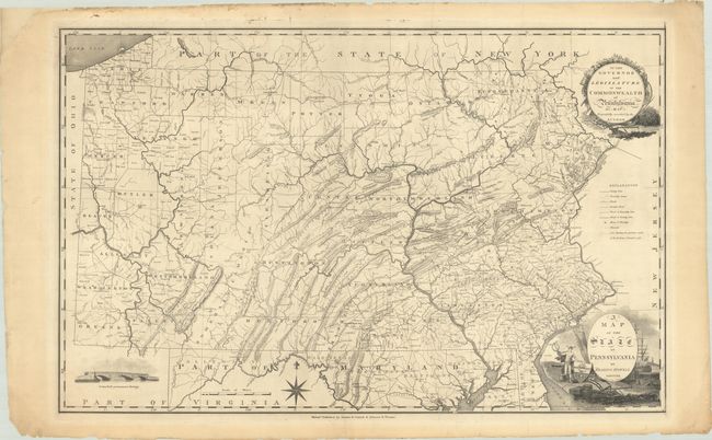
Reading Howell's map of Pennsylvania, first issued in 1792, is one of the most important maps of the state. Howell, a local surveyor, was commissioned by the state assembly in 1789 to make a new map based on both American and British military surveys from the Revolutionary War. Howell combined this new data with several of his own surveys to produce the most accurate map of Pennsylvania at the time. For the first time, the map laid out all counties and townships across the whole state, including the important Erie Triangle, which the United States sold to Pennsylvania that same year (and enabled the state to have a freshwater port). In addition to counties, other details include an extensive road network throughout, churches, coal deposits, and the Treaty of Fort Stanwix line (1768) in the northwest. The map is adorned by two decorative cartouches, compass rose, and illustration of the Schuylkill Permanent Bridge in Philadelphia, the first covered bridge in America. This notable map went through a number of editions through the years, with this version engraved by John Vallance and published by both Kimber & Conrad and Johnson & Warner. Howell's map would remain the standard map of Pennsylvania until John Melish's large wall map of 1822.
References: Phillips (Maps) p. 680; cf. Wheat & Brun #433.
Condition: B+
A crisp impression on a sturdy sheet with minor imperfections almost entirely in the blank margins including a number of archivally repaired edge tears (a few just enter the image), two repaired chips in the left blank margin, and some minor dampstaining in the top margin. There are two printer's creases along the top border and one at bottom.