Showing Unsold Lots(remove filter)
Filtered by Category:Books, Atlases, Travel Guides, Geography & Reference Books(Show All Categories)
Current Auction
16 lots
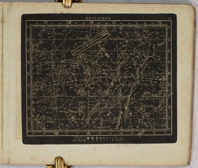
Lot 37
Subject: Celestial Atlas
Goldbach, Christian Friedrich
Neuester Himmels-Atlas zum Gebrauche sur Schul- und Akademischen Unterricht, nach Flamsteed, Bradley, Tob. Mayer, De la Caille, Le Francais de la Lande und v. Zach..., 1803
Size: 11.5 x 10 inches (29.2 x 25.4 cm)
Estimate: $2,000 - $2,400
Unique Celestial Atlas with Stars in Relief Against a Black Sky
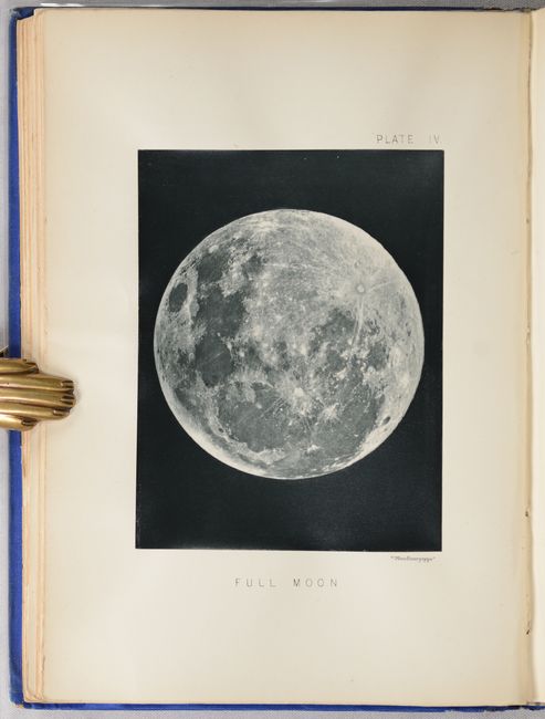
Lot 41
Subject: Moon
The Moon: Considered as a Planet, a World, and a Satellite, 1885
Size: 6.6 x 9.3 inches (16.8 x 23.6 cm)
Estimate: $1,000 - $1,300
Price reduced by $50 - Selenology with 25 Woodburytypes
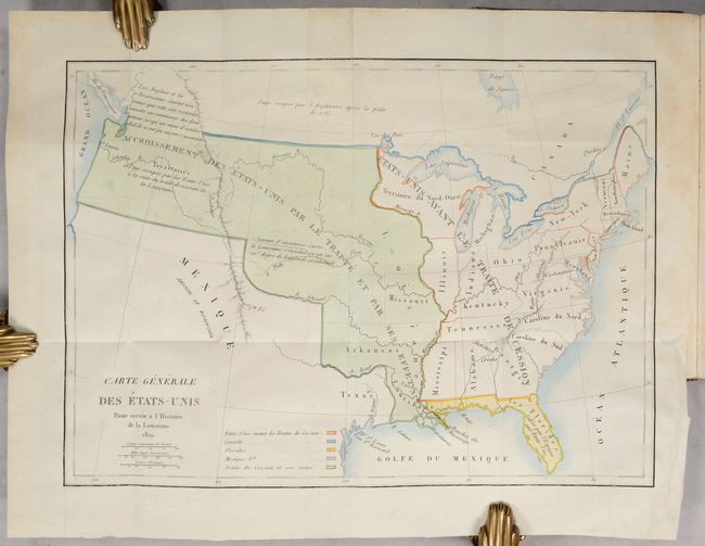
Lot 112
Subject: United States, Louisiana Purchase
Barbe-Marbois, Francois
[Map in Book] Carte Generale des Etats-Unis pour Servir a l'Histoire de la Louisiane [in] Histoire de la Louisiane et de la Cession de Cette Colonie par la France aux Etats-Unis de l'Amerique Septentrionale..., 1829
Size: 13.3 x 9.4 inches (33.8 x 23.9 cm)
Estimate: $800 - $1,000
Price reduced by $100! History of the Louisiana Purchase
Lot 136
Subject: Eastern United States, Revolutionary War
Marshall, John
[Atlas Volume] The Life of George Washington. Maps and Subscribers' Names, 1807
Size: 9.2 x 11.3 inches (23.4 x 28.7 cm)
Estimate: $1,000 - $1,300
Price reduced by $150!
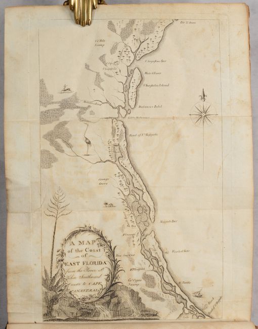
Lot 157
Subject: Southeastern United States
Bartram, William
Travels Through North & South Carolina, Georgia, East & West Florida, the Cherokee Country, the Extensive Territories of the Muscogulges, or Creek Confederacy, and the Country of the Chactaws..., 1791
Size: 5.9 x 9.8 inches (15 x 24.9 cm)
Estimate: $10,000 - $12,000
Price reduced by $750! Complete First Edition of Bartram's Work on the American Southeast
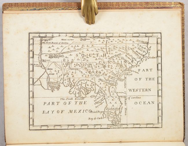
Lot 162
Subject: Colonial Southern United States
[Map in Book] [New Map of Georgia] [in] Reasons for Establishing the Colony of Georgia, with Regard to the Trade of Great Britain..., 1733
Size: 7.3 x 5.3 inches (18.5 x 13.5 cm)
Estimate: $5,500 - $6,500
First Printed Map to Name Georgia
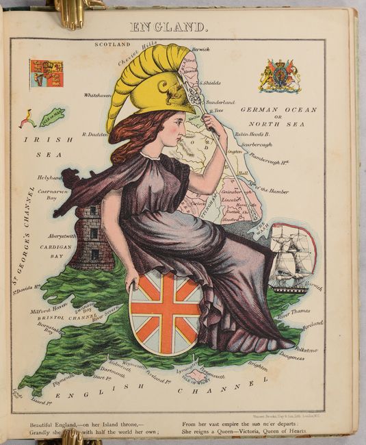
Lot 417
Subject: European Countries
Aleph
Geographical Fun: Being Humorous Outlines of Various Countries. With an Introduction and Descriptive Lines, 1869
Size: 9.3 x 11.1 inches (23.6 x 28.2 cm)
Estimate: $2,000 - $2,500
Price reduced by $150! Book with 12 Satirical Maps of European Countries
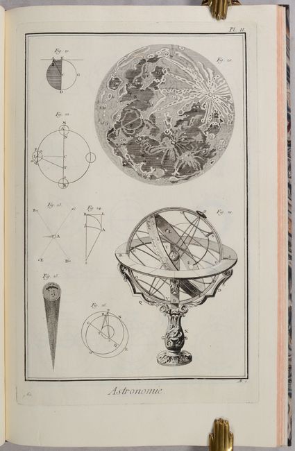
Lot 719
Subject: Prints - Astronomy
Diderot, Denis
Recueil de Planches sur les Sciences, les Arts Liberaux, et les Arts Mechaniques..., 1767
Size: 10.5 x 16.4 inches (26.7 x 41.7 cm)
Estimate: $800 - $950
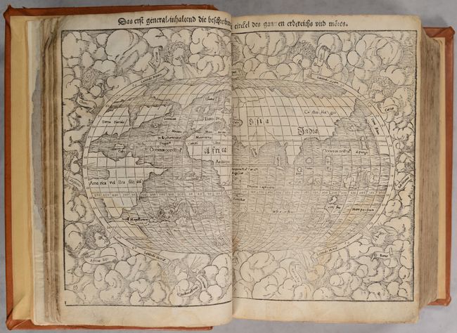
Lot 756
Subject: Atlases
Munster, Sebastian
[Cosmographey oder Beschreibung aller Länder], 1567
Size: 8.8 x 12.5 inches (22.4 x 31.8 cm)
Estimate: $12,000 - $15,000
Price reduced by $500! Superbly Bound Edition of Cosmographia with 115 Maps & Views
Lot 766
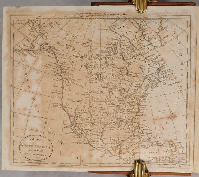
Subject: Geography Books
Morse, Jedidiah (Rev.)
[2 Volumes] The American Gazetteer, Exhibiting a Full Account of the Civil Divisions, Rivers, Harbours, Indian Tribes, &c. of the American Continent... [and] A New Gazetteer of the Eastern Continent..., 1802-04
Size: 5.3 x 8.6 inches (13.5 x 21.8 cm)
Estimate: $900 - $1,100
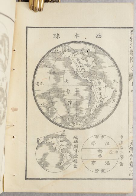
Lot 771
Subject: History Books
[Japanese Book - Hakubutsu Senkai], 1869
Size: 5 x 7.3 inches (12.7 x 18.5 cm)
Estimate: $275 - $350
Price reduced by $100!
Lot 772
Subject: History Books, Native Americans
Appleton & Company
Antiquities of the Southern Indians, Particularly of the Georgia Tribes, 1873
Size: 6.3 x 9.9 inches (16 x 25.1 cm)
Estimate: $650 - $800
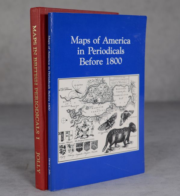
Lot 781
Subject: References
Jolly, David C.
[Lot of 2] Maps in British Periodicals Part I Major Monthlies Before 1800 [and] Maps of America in Periodicals Before 1800, 1989-90
Size: See Description
Estimate: $150 - $180
Price reduced by $20
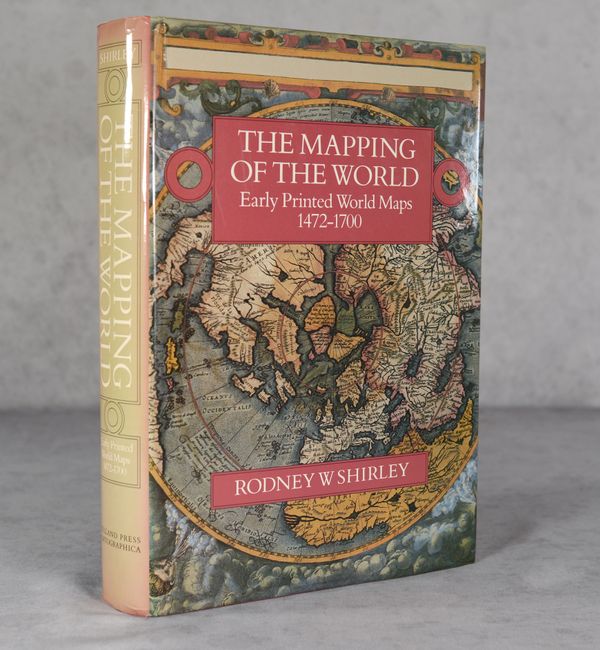
Lot 786
Subject: References, World
Shirley, Rodney W.
The Mapping of the World - Early Printed World Maps 1472-1700, 1987
Size: 9.7 x 13.8 inches (24.6 x 35.1 cm)
Estimate: $350 - $425
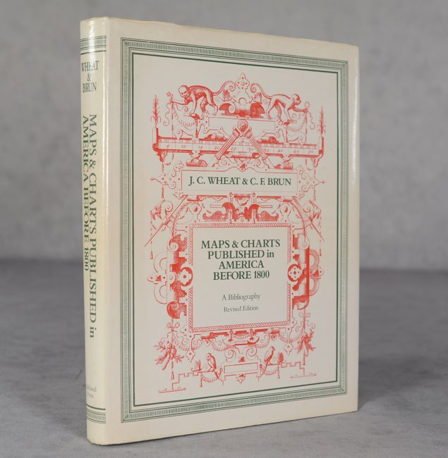
Lot 789
Subject: References, United States
Wheat and Brun
Maps and Charts Published in America Before 1800: A Bibliography - Second Revised Edition, 1985
Size: 7.8 x 10.1 inches (19.8 x 25.7 cm)
Estimate: $120 - $150
Price reduced by $40
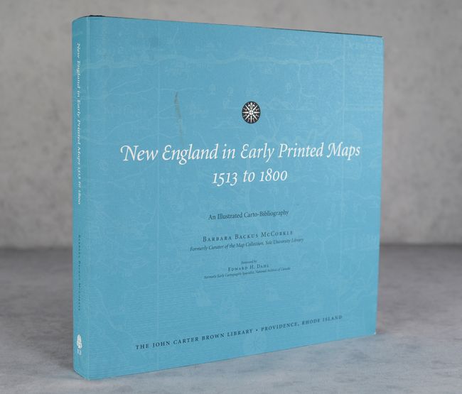
Lot 792
Subject: References, New England
McCorkle, Barbara B.
New England in Early Printed Maps 1513 to 1800 - An Illustrated Carto-Bibliography, 2001
Size: 12.3 x 11.8 inches (31.2 x 30 cm)
Estimate: $200 - $230
Price reduced by $50
16 lots