Showing Featured Lots(remove filter)
Showing results for:Auction 174
Catalog Archive
58 lots
Page 1 of 2
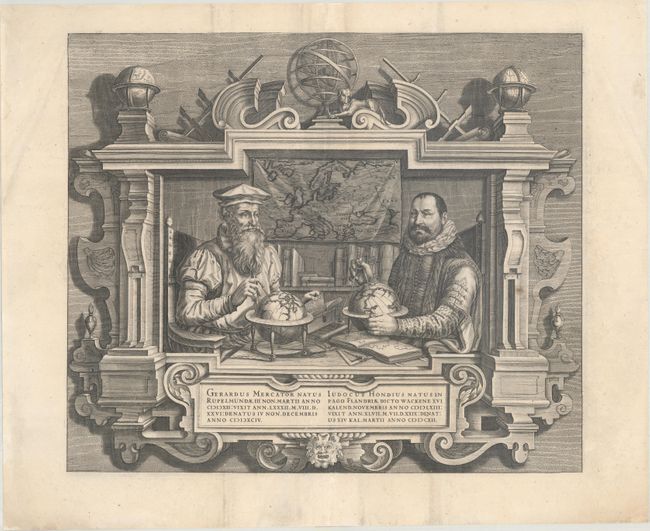
Auction 174, Lot 11
Subject: Portrait
Hondius
Gerardus Mercator... Iudocus Hondius..., 1619
Size: 17.8 x 15.1 inches (45.2 x 38.4 cm)
Estimate: $1,400 - $1,700
Famous Portraits of Mercator and Jodocus Hondius
Unsold
Closed on 9/11/2019
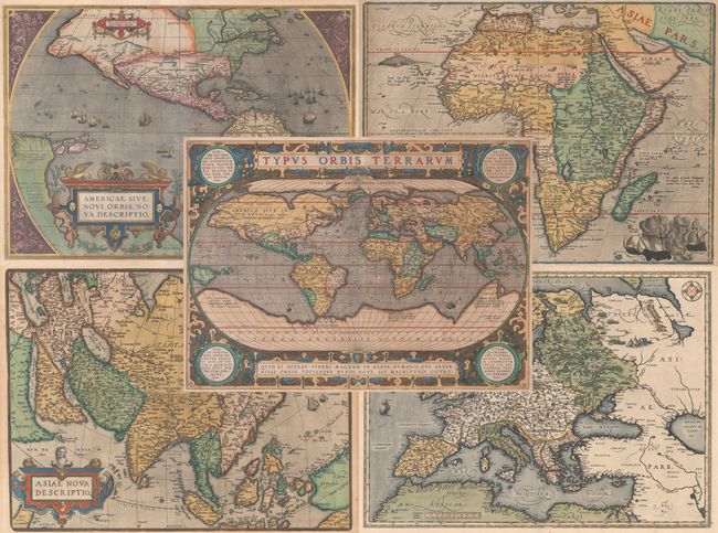
Auction 174, Lot 12
Subject: World & Continents
Ortelius, Abraham
[Lot of 5] Typus Orbis Terrarum [and] Americae sive Novi Orbis, Nova Descriptio [and] Africae Tabula Nova [and] Asiae Nova Descriptio [and] Europae, 1570-87
Size: See Description
Estimate: $14,000 - $17,000
Folio Set of Ortelius World and Continents
Sold for: $11,500
Closed on 9/11/2019
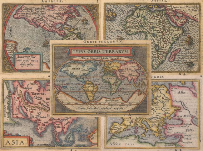
Auction 174, Lot 13
Subject: World & Continents
Ortelius/Galle
[Lot of 5] Typus Orbis Terrarum [and] Americae sive Novi Orbis Nova Descriptio [and] Africae Tabula Nova [and] Asia [and] Europa, 1590
Size: 4.3 x 3.1 inches (10.9 x 7.9 cm)
Estimate: $1,500 - $1,800
Matching Set of Miniature Ortelius Maps
Sold for: $1,200
Closed on 9/11/2019
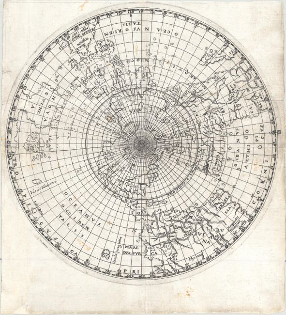
Auction 174, Lot 16
Subject: World
Ritter, Franz
[Untitled - World], 1613
Size: 8.1 x 8.1 inches (20.6 x 20.6 cm)
Estimate: $1,500 - $1,900
Ritter's Circular Sundial World Map
Sold for: $900
Closed on 9/11/2019
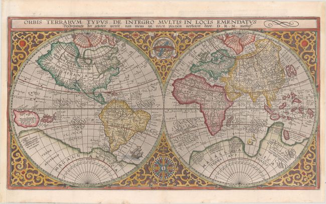
Auction 174, Lot 17
Subject: World
Plancius, Petrus
Orbis Terrarum Typus de Integro Multis in Locis Emendatus..., 1625
Size: 20.3 x 11.3 inches (51.6 x 28.7 cm)
Estimate: $2,750 - $3,500
Plancius' World Map Surrounded by Elegant Strapwork
Sold for: $2,100
Closed on 9/11/2019
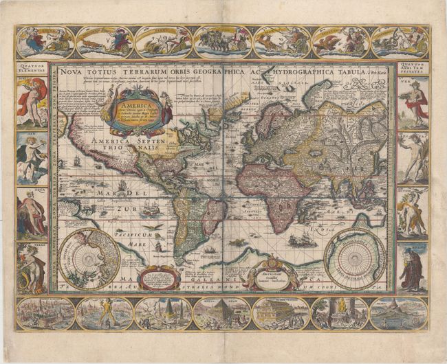
Auction 174, Lot 18
Subject: World
Keere, Pieter Van Den
Nova Totius Terrarum Orbis Geographica ac Hydrographica Tabula, 1640
Size: 21.1 x 15.7 inches (53.6 x 39.9 cm)
Estimate: $9,000 - $11,000
Van den Keere's Magnificent Carte-a-Figures World Map
Sold for: $6,000
Closed on 9/11/2019
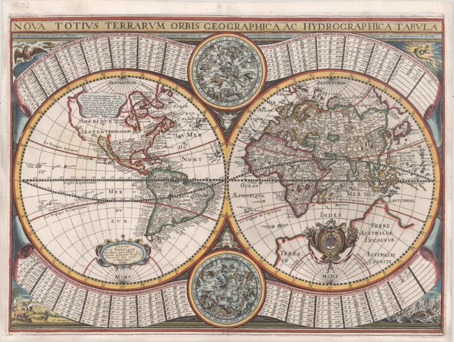
Auction 174, Lot 19
Subject: World
Sonnius, Jean
Nova Totius Terrarum Orbis Geographica ac Hydrographica Tabula, 1645
Size: 20.7 x 15.2 inches (52.6 x 38.6 cm)
Estimate: $6,000 - $7,500
Scarce World Map with Unusual Decorative Elements
Sold for: $4,500
Closed on 9/11/2019
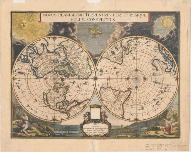
Auction 174, Lot 21
Subject: World
Blaeu/Valck
Novus Planiglobii Terrestris per Utrumque Polum Conspectus, 1695
Size: 21.3 x 16.1 inches (54.1 x 40.9 cm)
Estimate: $5,500 - $7,000
Superb World Map on a Polar Projection
Sold for: $4,000
Closed on 9/11/2019
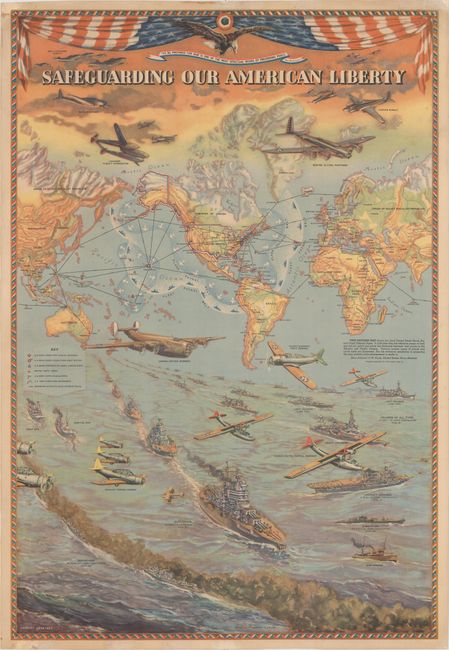
Auction 174, Lot 35
Subject: World, World War II
Hammond, C. S.
Safeguarding Our American Liberty, 1941
Size: 21 x 30.9 inches (53.3 x 78.5 cm)
Estimate: $1,900 - $2,200
Superb WWII Map Demonstrating the United States' Military Reach
Sold for: $1,800
Closed on 9/11/2019
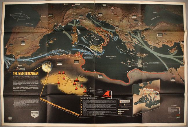
Auction 174, Lot 36
Subject: World, World War II
U.S. Navy Dept.
[Complete Set of 6 Nav War Maps - On 3 Sheets], 1944
Size: 57.2 x 38.1 inches (145.3 x 96.8 cm)
Estimate: $1,000 - $1,300
Complete Set of Nav War Maps
Sold for: $1,600
Closed on 9/11/2019
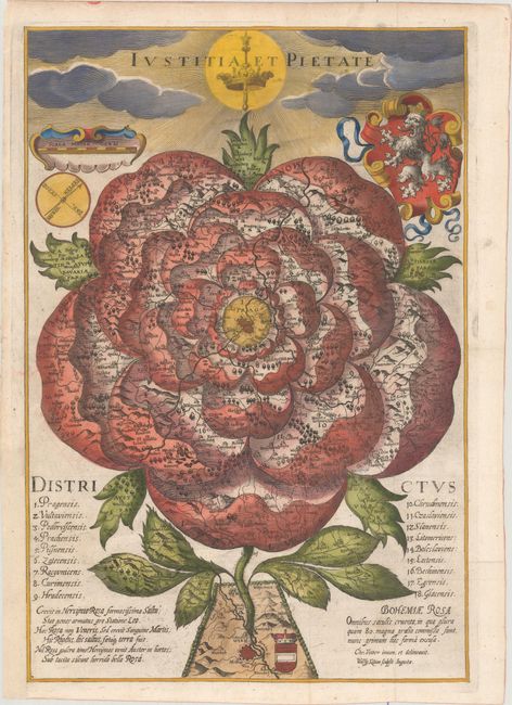
Auction 174, Lot 55
Subject: Cartographic Miscellany, Bohemia
Bohemiae Rosa Omnibus Saeculis Cruenta..., 1677
Size: 10.3 x 15.3 inches (26.2 x 38.9 cm)
Estimate: $1,600 - $2,000
Bohemia as a Rose
Sold for: $1,500
Closed on 9/11/2019
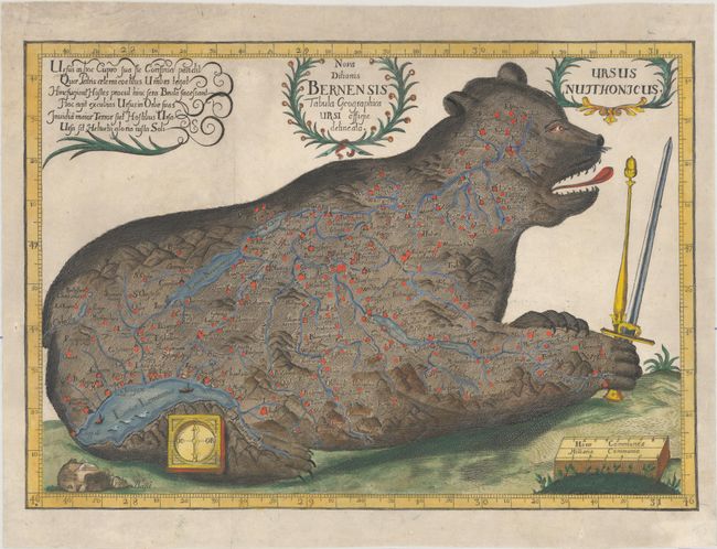
Auction 174, Lot 56
Subject: Cartographic Miscellany, Switzerland
Nova Ditionis Bernensis Tabula Geographica Ursi Effigie Delineata / Ursus Nuithonicus, 1710
Size: 13.5 x 9.4 inches (34.3 x 23.9 cm)
Estimate: $1,300 - $1,600
Very Rare Zoomorphic Map
Sold for: $900
Closed on 9/11/2019
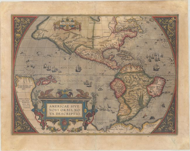
Auction 174, Lot 65
Subject: Western Hemisphere - America
Ortelius, Abraham
Americae sive Novi Orbis, Nova Descriptio, 1601
Size: 19 x 13.9 inches (48.3 x 35.3 cm)
Estimate: $4,000 - $4,750
Ortelius' Influential Map of the New World
Unsold
Closed on 9/11/2019
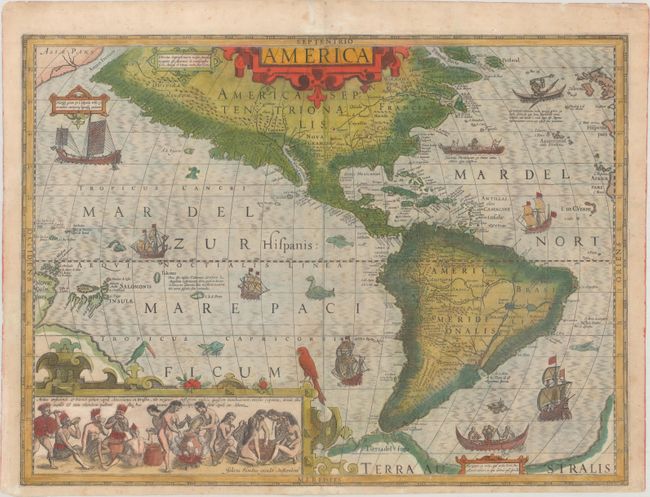
Auction 174, Lot 66
Subject: Western Hemisphere - America
Hondius, Jodocus
America, 1623
Size: 19.8 x 14.8 inches (50.3 x 37.6 cm)
Estimate: $3,000 - $3,750
Hondius' Important Map of the Americas
Sold for: $2,200
Closed on 9/11/2019
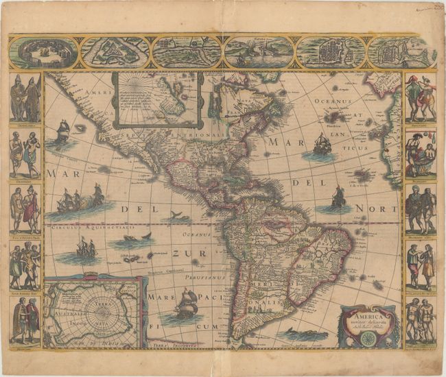
Auction 174, Lot 67
Subject: Western Hemisphere - America
Hondius/Jansson
America Noviter Delineata, 1638
Size: 21.8 x 16.2 inches (55.4 x 41.1 cm)
Estimate: $4,000 - $5,000
Jansson's Carte-a-Figures Map of the Americas
Sold for: $2,500
Closed on 9/11/2019
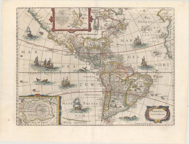
Auction 174, Lot 69
Subject: Western Hemisphere - America
Hondius/Jansson
America Noviter Delineata, 1645
Size: 19.8 x 14.9 inches (50.3 x 37.8 cm)
Estimate: $2,200 - $2,500
Jansson's Decorative Map of the Americas
Unsold
Closed on 9/11/2019
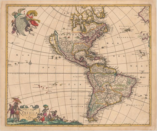
Auction 174, Lot 71
Subject: Western Hemisphere - America
Wit, Frederick de
Novissima et Accuratissima Totius Americae Descriptio, 1680
Size: 23 x 19.3 inches (58.4 x 49 cm)
Estimate: $1,400 - $1,700
De Wit's Derivative of Visscher's Classic Map of the Americas with the Island of California
Sold for: $1,300
Closed on 9/11/2019
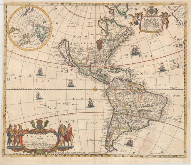
Auction 174, Lot 72
Subject: Western Hemisphere - America
Lea & Overton
A New Mapp of America Devided According to the Best and Latest Observations and Discoveries Wherein Are Described by Thear Proper Names the Seaverall Countries That Belonge to ye English..., 1688
Size: 22.2 x 18.8 inches (56.4 x 47.8 cm)
Estimate: $5,000 - $6,500
Scarce Map of the Americas - One of the Earliest Maps by Philip Lea
Sold for: $4,500
Closed on 9/11/2019
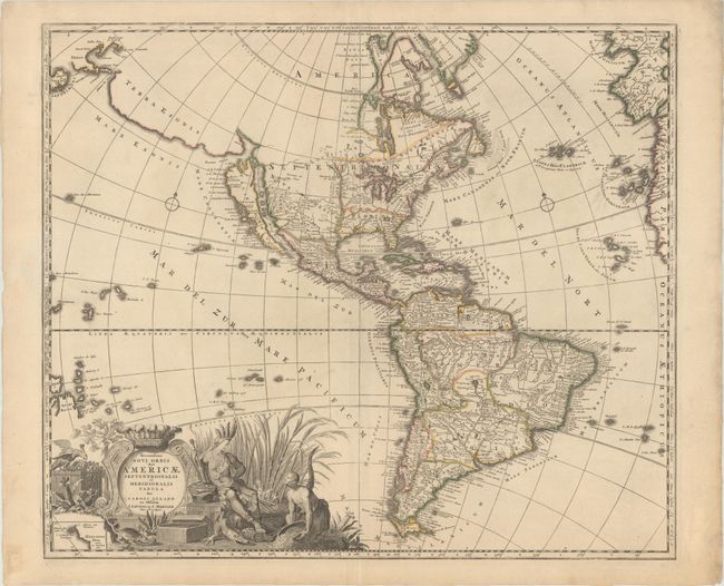
Auction 174, Lot 74
Subject: Western Hemisphere - America
Allard/Covens & Mortier
Recentissima Novi Orbis, sive Americae Septentrionalis et Meridionalis Tabula, 1725
Size: 23.1 x 19.6 inches (58.7 x 49.8 cm)
Estimate: $1,700 - $2,000
Allard's Elaborate Map of the Western Hemisphere
Sold for: $1,300
Closed on 9/11/2019
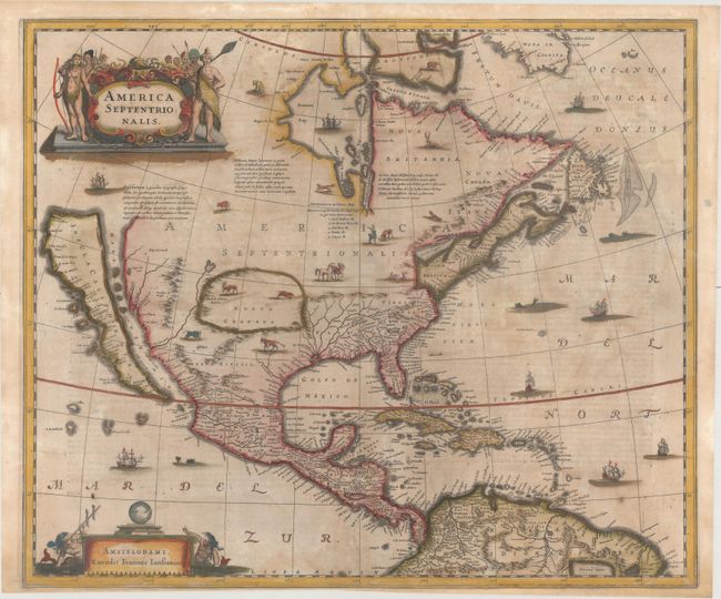
Auction 174, Lot 88
Subject: Colonial North America
Hondius/Jansson
America Septentrionalis, 1647
Size: 21.8 x 18.3 inches (55.4 x 46.5 cm)
Estimate: $1,600 - $1,900
One of the Most Important Maps Perpetuating the Myth of the Island of California
Sold for: $2,750
Closed on 9/11/2019
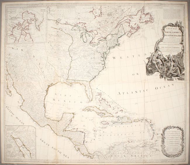
Auction 174, Lot 94
Subject: North America
Sayer, Robert
A New Map of North America, with the West India Islands. Divided According to the Preliminary Articles of Peace, Signed at Versailles, 20, Jan. 1783..., 1786
Size: 45.9 x 39.9 inches (116.6 x 101.3 cm)
Estimate: $2,400 - $3,000
Important Large Map of North America Featuring the Young United States
Sold for: $1,800
Closed on 9/11/2019
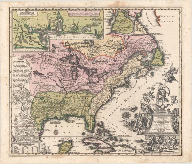
Auction 174, Lot 102
Subject: Colonial Eastern North America & West Indies
Seutter, Matthias
Accurata Delineatio Celeberrimae Regionis Ludovicianae vel Gallice Louisiane ol. Canadae et Floridae ad Poliatione in Septemtrionali America Descriptae quae Hodie Nomine Fluminis Mississippi..., 1730
Size: 22.3 x 19.3 inches (56.6 x 49 cm)
Estimate: $2,750 - $3,500
Map Focusing on the Mississippi River and the "Mississippi Bubble"
Sold for: $1,750
Closed on 9/11/2019
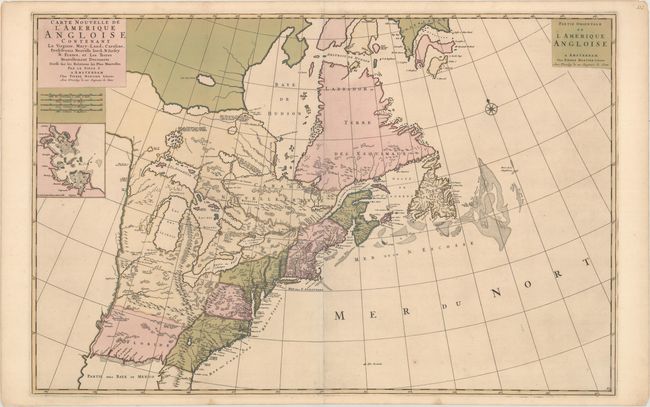
Auction 174, Lot 111
Subject: Colonial Eastern United States & Canada
Mortier, Pierre
Carte Nouvelle de l'Amerique Angloise Contenant la Virginie, Mary-Land, Caroline, Pensylvania Nouvelle Iorck. N: Iarsey N: France, et les Terres Nouvellement Decouerte..., 1700
Size: 35.9 x 23.5 inches (91.2 x 59.7 cm)
Estimate: $2,200 - $2,500
A Map Showing Fascinating Geographic Misconceptions in Colonial America
Sold for: $1,200
Closed on 9/11/2019
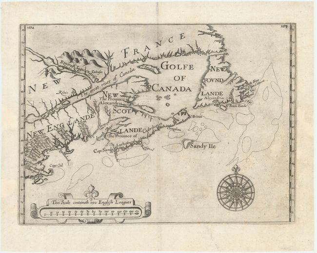
Auction 174, Lot 114
Subject: Colonial Northeastern United States & Canada
Alexander, William (Sir)
[Untitled - Northeastern United States & Canada], 1625
Size: 13.5 x 9.8 inches (34.3 x 24.9 cm)
Estimate: $5,500 - $7,000
The First Map to Name New Scotland
Sold for: $4,000
Closed on 9/11/2019
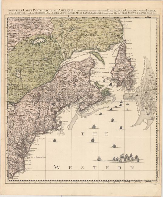
Auction 174, Lot 115
Subject: Colonial Northeastern United States & Canada
Popple/Covens & Mortier
Nouvelle Carte Particuliere de l'Amerique ou sont Exactement Marquees la Nouvelle Bretagne, le Canada ou Nouvelle France, la Nouvelle Ecosse, la Nouvelle Angleterre, la Nouvelle York, la Pensilvanie, Mary-Land, la Caroline Septentrionale..., 1741
Size: 20.7 x 22.5 inches (52.6 x 57.2 cm)
Estimate: $2,200 - $2,500
The Northeastern Sheet of the Reduced-Size Edition of Popple's Map
Sold for: $1,600
Closed on 9/11/2019
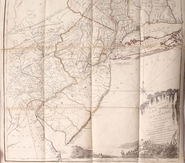
Auction 174, Lot 116
Subject: Colonial Northeastern United States & Quebec
Holland/Pownal
The Provinces of New York, and New Jersey; with Part of Pensilvania, and the Province of Quebec..., 1776
Size: 21.5 x 53.3 inches (54.6 x 135.4 cm)
Estimate: $4,000 - $4,750
Thomas Jefferys' Important Revolutionary War Period Map
Sold for: $2,500
Closed on 9/11/2019
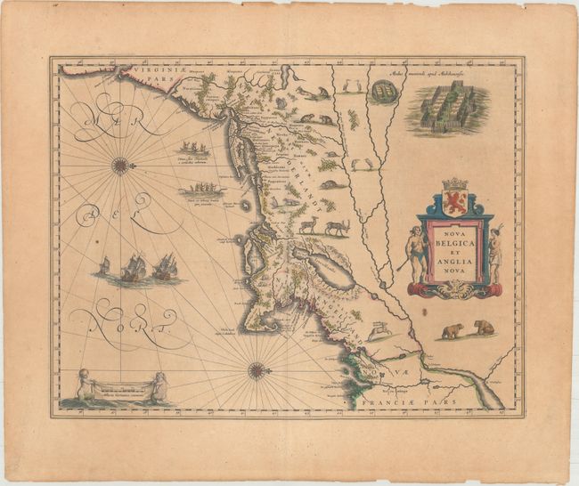
Auction 174, Lot 139
Subject: Colonial New England & Mid-Atlantic United States
Blaeu, Willem
Nova Belgica et Anglia Nova, 1643
Size: 19.8 x 15.1 inches (50.3 x 38.4 cm)
Estimate: $1,900 - $2,200
Important Map of Colonial New England and the Mid-Atlantic
Sold for: $1,150
Closed on 9/11/2019
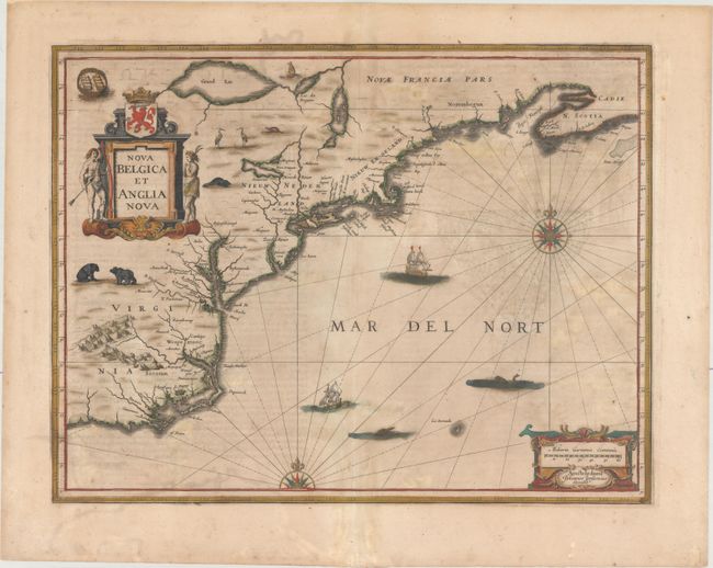
Auction 174, Lot 140
Subject: Colonial New England & Mid-Atlantic United States
Jansson, Jan
Nova Belgica et Anglia Nova, 1647
Size: 19.8 x 15.2 inches (50.3 x 38.6 cm)
Estimate: $1,500 - $1,800
Jansson's Influential Map of the East Coast
Sold for: $1,000
Closed on 9/11/2019
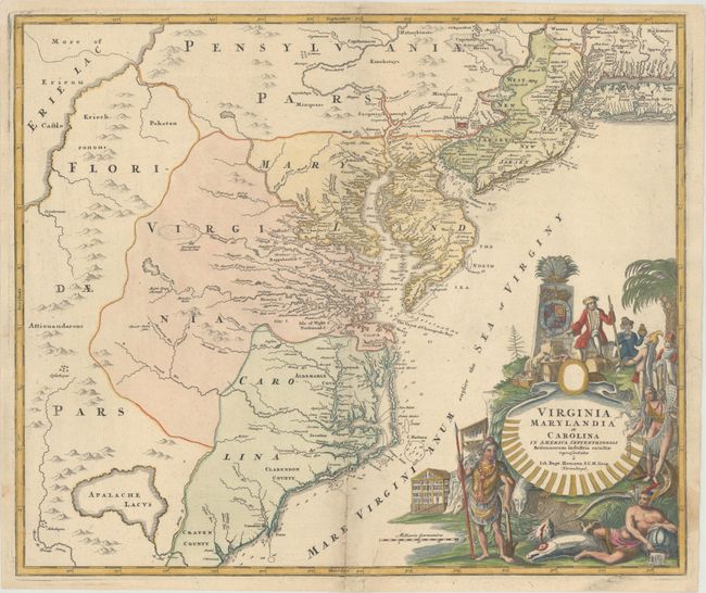
Auction 174, Lot 151
Subject: Colonial Mid-Atlantic United States
Homann, Johann Baptist
Virginia Marylandia et Carolina in America Septentrionali Britannorum Industria Excultae Repraesentatae, 1730
Size: 22.8 x 19.1 inches (57.9 x 48.5 cm)
Estimate: $1,600 - $2,000
Map Created to Promote German Immigration to the New World
Sold for: $1,200
Closed on 9/11/2019
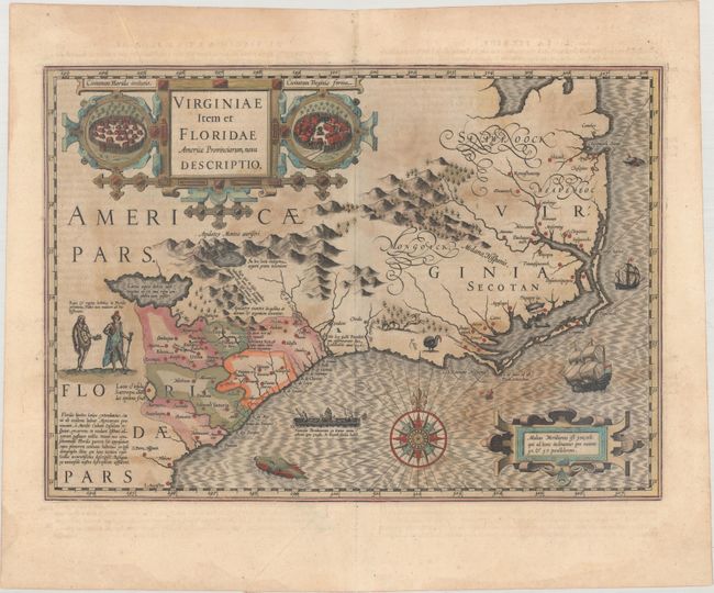
Auction 174, Lot 157
Subject: Colonial Southeastern United States
Hondius, Jodocus
Virginiae Item et Floridae Americae Provinciarum, Nova Descriptio, 1613
Size: 19 x 13.4 inches (48.3 x 34 cm)
Estimate: $1,800 - $2,100
A Seminal Map of the Southeast and Early American Cartography
Sold for: $1,000
Closed on 9/11/2019
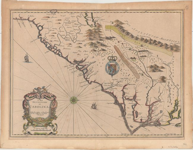
Auction 174, Lot 159
Subject: Colonial Southeastern United States
Speed/Lamb
A New Description of Carolina, 1676
Size: 20.1 x 14.8 inches (51.1 x 37.6 cm)
Estimate: $3,000 - $3,750
Speed's Map of the Carolinas Based Upon the Lords Proprietor's Map
Sold for: $2,000
Closed on 9/11/2019
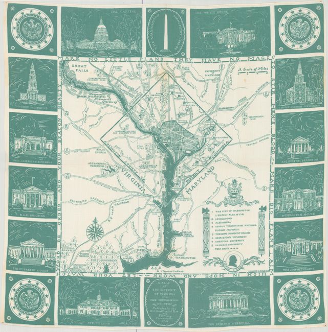
Auction 174, Lot 207
Subject: Washington, D.C.
A Map of the District of Columbia and the Surrounding Country, 1933
Size: 25.9 x 25.9 inches (65.8 x 65.8 cm)
Estimate: $550 - $750
Uncommon Handkerchief Map of DC Based on Original L'Enfant Plan
Unsold
Closed on 9/11/2019
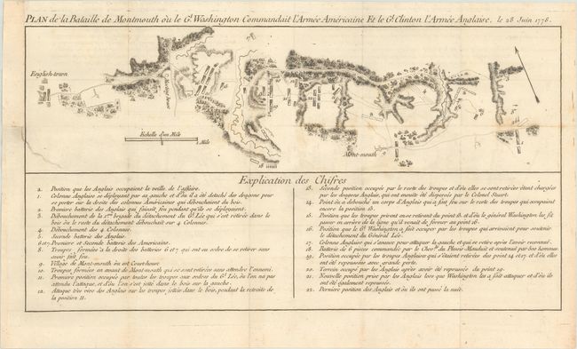
Auction 174, Lot 230
Subject: Monmouth, New Jersey
Plan de la Bataille de Montmouth ou le Gl. Washington Commandait l'Armee Americaine et le Gl. Clinton l'Armee Anglaise, le 28 Juin 1778, 1782
Size: 15.4 x 8.1 inches (39.1 x 20.6 cm)
Estimate: $1,000 - $1,300
An Important Battle Plan of the American Revolution
Sold for: $700
Closed on 9/11/2019
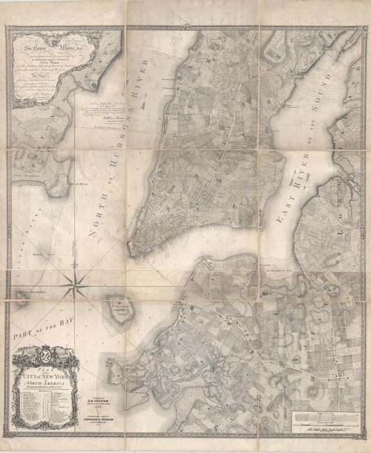
Auction 174, Lot 235
Subject: New York City, New York
Colton, Joseph Hutchins
Plan of the City of New York in North America Surveyed in the Years 1766 & 1767, 1853
Size: 35.3 x 40.2 inches (89.7 x 102.1 cm)
Estimate: $2,750 - $3,500
Colton's Rare Edition of the "Ratzer Map" of New York City
Sold for: $6,500
Closed on 9/11/2019
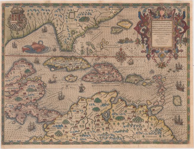
Auction 174, Lot 293
Subject: Gulf of Mexico & Caribbean
Bry, Theodore de
Occidentalis Americae Partis, vel, Earum Regionum quas Christophorus Columbus Primu Detexit Tabula Chorographicae Multorum Auctorum Scriptis..., 1594
Size: 17.3 x 13 inches (43.9 x 33 cm)
Estimate: $7,000 - $8,500
De Bry's Superb Map of the Southeastern US, Caribbean & Northern South America
Unsold
Closed on 9/11/2019
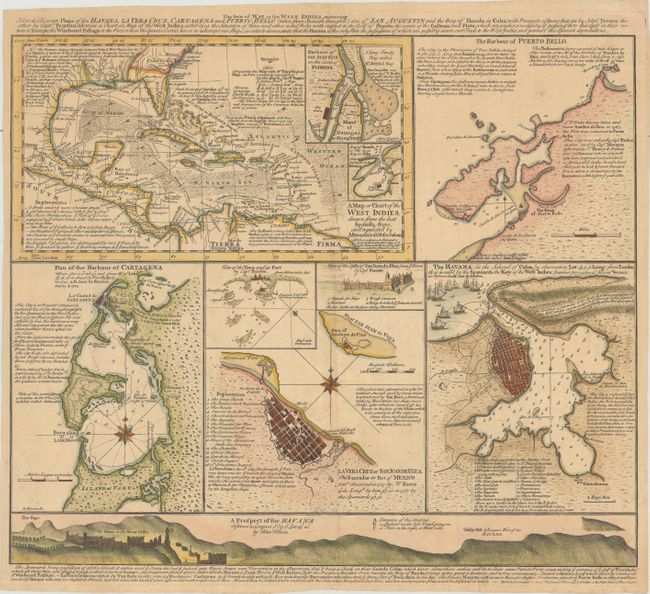
Auction 174, Lot 296
Subject: Gulf of Mexico & Caribbean
Foster, George
The Seat of War in the West Indies, Containing New & Accurate Plans of the Havana, la Vera Cruz, Cartagena and Puerto Bello..., 1740
Size: 18.2 x 15.4 inches (46.2 x 39.1 cm)
Estimate: $1,400 - $1,700
Separately-Issued Sheet Illustrating the War of Jenkins' Ear
Sold for: $1,000
Closed on 9/11/2019
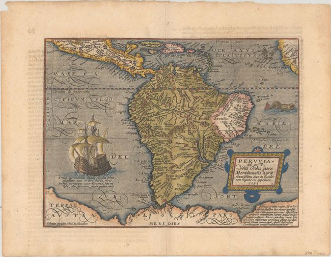
Auction 174, Lot 321
Subject: South America
Quad, Matthias von Kinckelbach
Peruvia id est, Novi Orbis Pars Meridionalis a Praestantissima eius in Occidentem Regione sic Appellata, 1598
Size: 11.1 x 8.2 inches (28.2 x 20.8 cm)
Estimate: $1,400 - $1,700
Quad's Ornately Engraved Map of South America
Sold for: $1,000
Closed on 9/11/2019
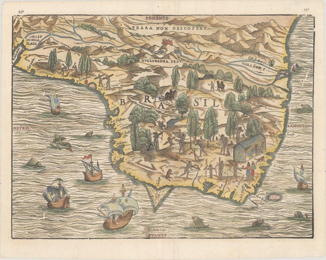
Auction 174, Lot 340
Subject: Brazil
Ramusio, Giovanni Battista
Brasil, 1606
Size: 14.3 x 10.6 inches (36.3 x 26.9 cm)
Estimate: $1,000 - $1,300
One of the Earliest Obtainable Maps of Brazil
Sold for: $750
Closed on 9/11/2019
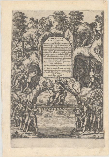
Auction 174, Lot 360
Subject: Peru, Panama & Colombia, Natives
Bry, Theodore de
[Grands Voyages, Part VI - Lot of 29 Engravings] Americae Pars Sexta..., 1596
Size: 8.3 x 11.5 inches (21.1 x 29.2 cm)
Estimate: $3,500 - $4,250
28 Engravings and a Title Page from Benzoni's Account
Sold for: $1,900
Closed on 9/11/2019
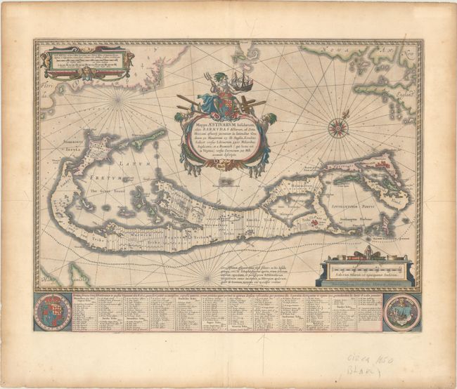
Auction 174, Lot 377
Subject: Bermuda
Blaeu, Willem
Mappa Aestivarum Insularum, Alias Barmudas Dictarum, ad Ostia Mexicani Aestuary..., 1642
Size: 21 x 15.9 inches (53.3 x 40.4 cm)
Estimate: $1,400 - $1,700
Map of Bermuda Based on Richard Norwood's Famous Survey
Unsold
Closed on 9/11/2019
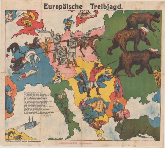
Auction 174, Lot 390
Subject: Europe, World War I
Europaische Treibjagd, 1914
Size: 16.4 x 14 inches (41.7 x 35.6 cm)
Estimate: $1,400 - $1,800
Rare German Propaganda Map at Start of World War I
Sold for: $1,000
Closed on 9/11/2019
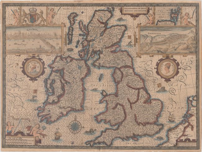
Auction 174, Lot 395
Subject: Britain
Speed, John
The Kingdome of Great Britaine and Ireland, 1610
Size: 20.1 x 15 inches (51.1 x 38.1 cm)
Estimate: $2,500 - $3,250
Speed's Famous Map of the British Isles Engraved by Hondius
Sold for: $1,500
Closed on 9/11/2019
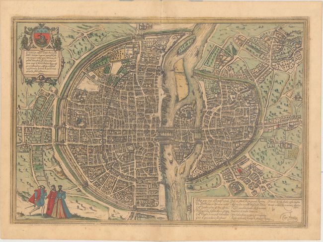
Auction 174, Lot 466
Subject: Paris, France
Braun & Hogenberg
Lutetia vulgari Nomine Paris, Urbs Galliae Maxima, Sequana Navigabili Flumine Irrigatur…, 1575
Size: 19.1 x 13.6 inches (48.5 x 34.5 cm)
Estimate: $2,500 - $3,250
Braun & Hogenberg's Plan of Paris
Sold for: $1,800
Closed on 9/11/2019
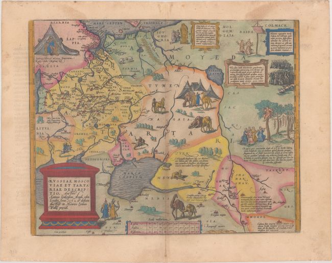
Auction 174, Lot 547
Subject: Russia, Eastern Europe & Central Asia
Ortelius, Abraham
Russiae, Moscoviae et Tartariae Descriptio. Auctore Antonio Ienkensono Anglo..., 1579
Size: 17.2 x 13.6 inches (43.7 x 34.5 cm)
Estimate: $1,900 - $2,200
Ortelius' Map of Russia with a Vignette of Ivan the Terrible
Unsold
Closed on 9/11/2019
Auction 174, Lot 622
Subject: Mediterranean Islands
Bordone, Benedetto
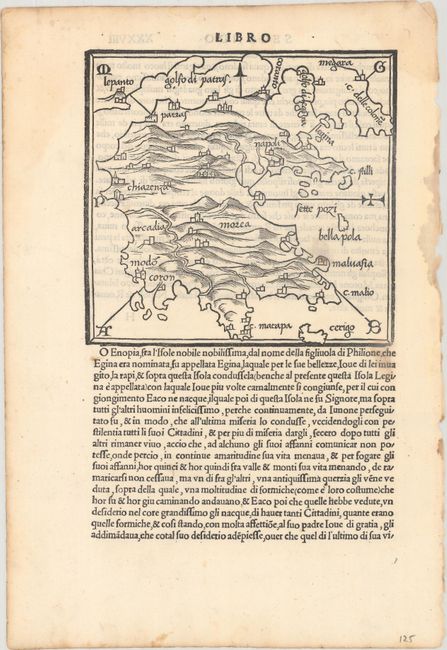
[Lot of 21 - 49 Maps of Mediterranean Islands], 1534
Size: 8.3 x 12.1 inches (21.1 x 30.7 cm)
Estimate: $1,900 - $2,200
49 Maps of Mediterranean Islands from Bordone's Isolario
Sold for: $950
Closed on 9/11/2019
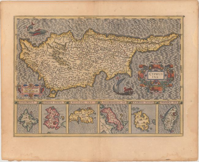
Auction 174, Lot 627
Subject: Cyprus
Hondius, Jodocus
Cyprus Ins:, 1619
Size: 19.5 x 13.9 inches (49.5 x 35.3 cm)
Estimate: $1,000 - $1,300
Hondius' Elegant Map of Cyprus
Unsold
Closed on 9/11/2019
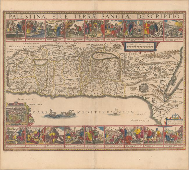
Auction 174, Lot 659
Subject: Holy Land
Jansson, Jan
Palestina, sive Terrae Sanctae Descriptio, 1684
Size: 22.1 x 17 inches (56.1 x 43.2 cm)
Estimate: $1,600 - $2,000
Decorative Map Featuring 18 Biblical Scenes
Sold for: $1,300
Closed on 9/11/2019
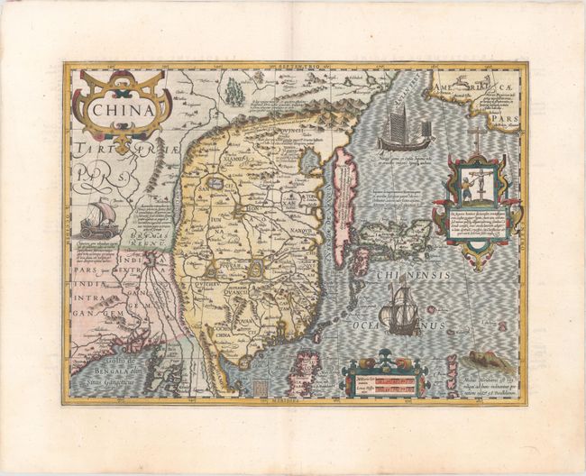
Auction 174, Lot 705
Subject: China, Korea & Japan
Mercator/Hondius
China, 1619
Size: 18.3 x 13.5 inches (46.5 x 34.3 cm)
Estimate: $2,400 - $3,000
Hondius' Map of China, Korea, and Japan
Sold for: $1,800
Closed on 9/11/2019
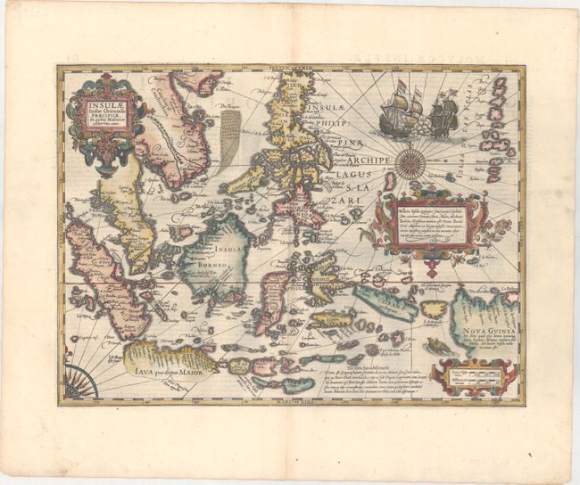
Auction 174, Lot 716
Subject: East Indies - Indonesia
Mercator/Hondius
Insulae Indiae Orientalis Praecipuae, in Quibus Moluccae Celeberrimae sunt, 1630
Size: 18.4 x 13.4 inches (46.7 x 34 cm)
Estimate: $3,000 - $4,000
Hondius' Decorative Map of the Spice Islands
Sold for: $2,200
Closed on 9/11/2019
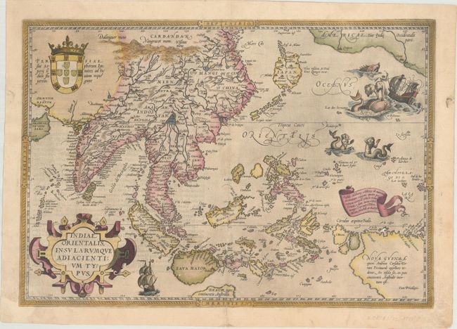
Auction 174, Lot 722
Subject: Southern & Southeast Asia
Ortelius, Abraham
Indiae Orientalis, Insularumque Adiacientium Typus, 1588
Size: 19.4 x 13.6 inches (49.3 x 34.5 cm)
Estimate: $2,000 - $2,300
Ortelius' Important Map of Southeast Asia
Unsold
Closed on 9/11/2019
58 lots
Page 1 of 2