Subject: Southern & Southeast Asia
Period: 1588 (published)
Publication: Theatrum Orbis Terrarum
Color: Hand Color
Size:
19.4 x 13.6 inches
49.3 x 34.5 cm
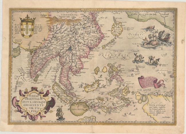
Ortelius' important map of Southeast Asia, based on Mercator's 1569 World map, shows how sketchy the available information was concerning the region. The East Indies are presented as a randomly scattered archipelago with Java and Borneo particularly misshapen. Taiwan is mapped for the first time as I. Fermosa in the 'tail' of kite-shaped Japan's Lequaio islands. The fictitious Chyamai lacus is the source of a network of major rivers in Southeast Asia. Beach pars, a presumed promontory of the great southern continent based on Marco Polo's account, protrudes into the bottom of the map. In the upper right corner, America makes an appearance with the three coastal cities of Quivira, Cicuie, and Tiguex. Near the shore lies a ship being menaced by a pair of sea monsters, while twin mermaids preen before each other near the Ladrone Islands. Spanish text on verso marked page 94.
References: Van den Broecke #166; Suarez, pp 164-69.
Condition: B
An attractive example in full contemporary color on watermarked paper with several small areas of cracking at bottom due to oxidation of the green pigment. There is a tiny amount of loss just above New Guinea and a minute amount of loss on Java. There is an archivally repaired 2" centerfold separation at bottom, and small edge chips at bottom left and right that has been professionally replaced with a minor amount of border in facsimile.