Showing Featured Lots(remove filter)
Showing results for:Auction 161
Catalog Archive
95 lots
Page 1 of 2
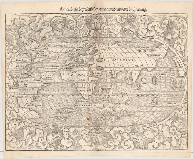
Auction 161, Lot 2
Subject: World
Munster, Sebastian
General Tafel Begreifend der Gantzen Undern Weldt Beschreibung, 1548
Size: 13.6 x 10.3 inches (34.5 x 26.2 cm)
Estimate: $5,500 - $7,000
Rare First Block of Munster's World Map
Sold for: $2,750
Closed on 2/8/2017
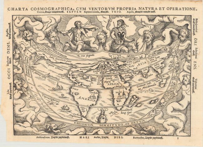
Auction 161, Lot 3
Subject: World
Apianus, Peter Bienewitz
Charta Cosmographica, cum Ventorum Propria Natura et Operatione, 1553
Size: 10.9 x 7.4 inches (27.7 x 18.8 cm)
Estimate: $4,000 - $5,000
Apianus' Popular Cordiform World Map
Unsold
Closed on 2/8/2017
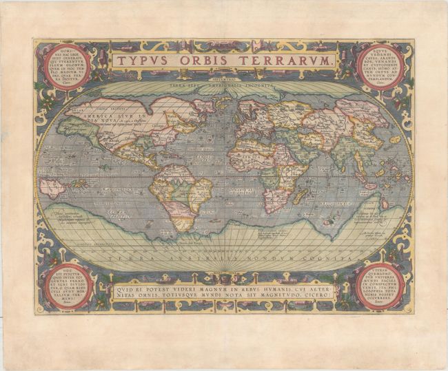
Auction 161, Lot 5
Subject: World
Ortelius, Abraham
Typus Orbis Terrarum, 1587
Size: 19.1 x 13.9 inches (48.5 x 35.3 cm)
Estimate: $6,000 - $7,500
Ortelius' Third World Map in an Oval Projection
Sold for: $4,000
Closed on 2/8/2017
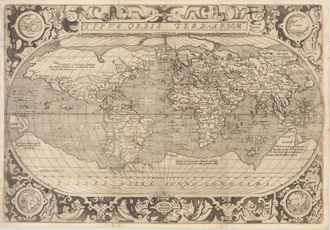
Auction 161, Lot 7
Subject: World
Solis, Hernando de
Tipus Orbis Terrarum, 1603
Size: 19.1 x 13.1 inches (48.5 x 33.3 cm)
Estimate: $3,000 - $4,000
Rare, Early Spanish Map of the World
Sold for: $2,200
Closed on 2/8/2017
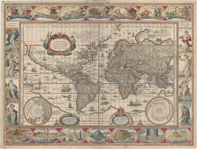
Auction 161, Lot 8
Subject: World
Blaeu, Willem
Nova Totius Terrarum Orbis Geographica ac Hydrographica Tabula, 1640
Size: 21.3 x 16.1 inches (54.1 x 40.9 cm)
Estimate: $9,500 - $11,000
Blaeu's Magnificent Carte-a-Figures World Map with Rare Blank Verso
Sold for: $5,700
Closed on 2/8/2017
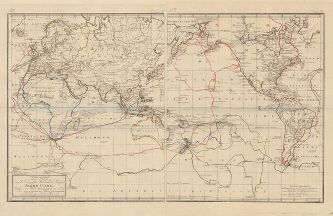
Auction 161, Lot 26
Subject: World
Schraembl, Franz Anton
[On 2 Sheets] Generalkarte Soemmtlicher Entdeckungen auf den drei Grossen Weltreisen des Kapit. Jakob Cook. Verflast von Herrn Heinrich Roberts…, 1789
Size: 17.7 x 21 inches (45 x 53.3 cm)
Estimate: $1,400 - $1,700
Gorgeous Map Showing Captain Cook's Routes
Sold for: $1,000
Closed on 2/8/2017
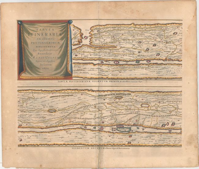
Auction 161, Lot 36
Subject: Ancient World
Jansson, Jan
[On 4 Sheets] Tabula Itineraria ex Illustri Peutingerorum Bibliotheca..., 1662
Size: 20.1 x 15.5 inches (51.1 x 39.4 cm)
Estimate: $2,500 - $3,250
Jansson's Famous Peutinger Table
Sold for: $1,600
Closed on 2/8/2017
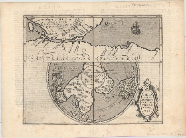
Auction 161, Lot 42
Subject: South Pole, Southern South America
Metellus, Natalius Sequanus
Chica sive Patagonica et Australis Terra, 1598
Size: 11.3 x 8.9 inches (28.7 x 22.6 cm)
Estimate: $1,600 - $1,800
Metellus's Rare Reduced Version of Wytfliet's Map of Terra Australis
Unsold
Closed on 2/8/2017
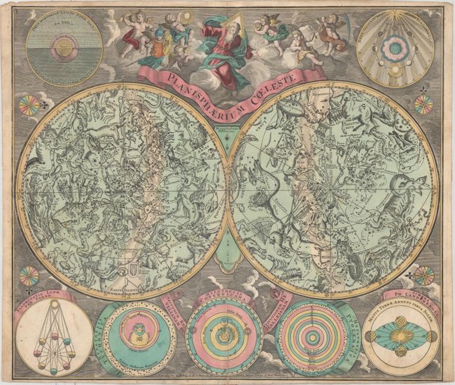
Auction 161, Lot 43
Subject: Celestial
Seutter, Matthias
Planisphaerium Coeleste Secundum Restitutionem Hevelianam et Hallejanam, 1745
Size: 22.3 x 19.4 inches (56.6 x 49.3 cm)
Estimate: $1,600 - $1,900
Seutter's Striking Celestial Chart
Sold for: $1,000
Closed on 2/8/2017
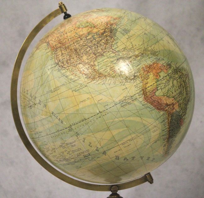
Auction 161, Lot 47
Subject: Globes
Anon.
[13" Globe] [Untitled - Swedish Globe], 1904
Size: 14 x 23 inches (35.6 x 58.4 cm)
Estimate: $1,100 - $1,400
Gorgeous Swedish Terrestrial Globe
Sold for: $550
Closed on 2/8/2017
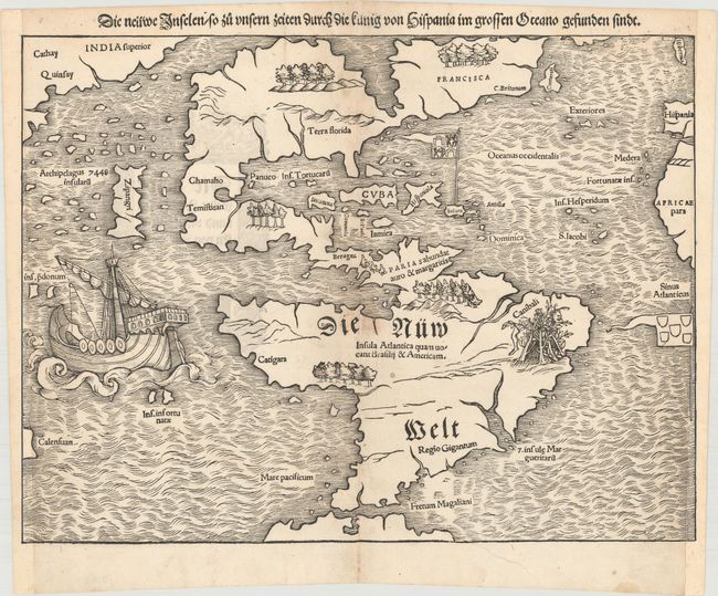
Auction 161, Lot 56
Subject: Western Hemisphere - America
Munster, Sebastian
Die Neuwe Inselen / so zu Unsern Zeiten Durch die Kunig von Hispania im Grossen Oceano Gefunden Sindt, 1548
Size: 13.4 x 10.1 inches (34 x 25.7 cm)
Estimate: $4,750 - $6,000
Rare Early State of One of the Most Important 16th Century Maps of the New World
Sold for: $2,750
Closed on 2/8/2017
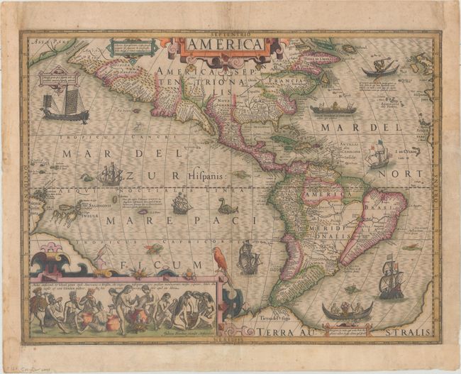
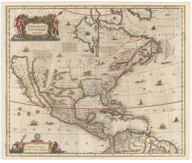
Auction 161, Lot 57
Subject: Western Hemisphere - America
Hondius, Jodocus
America, 1619
Size: 19.8 x 14.8 inches (50.3 x 37.6 cm)
Estimate: $3,000 - $3,750
Hondius' Important Map of the Americas in Full Original Color
Sold for: $2,500
Closed on 2/8/2017
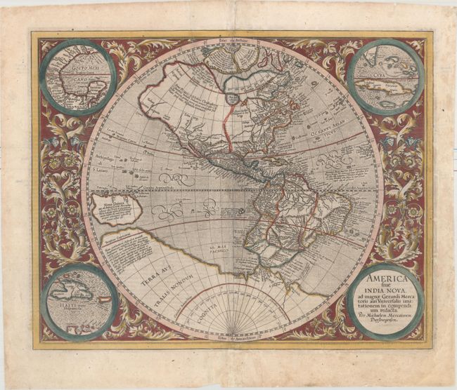
Auction 161, Lot 58
Subject: Western Hemisphere - America
Mercator/Hondius
America sive India Nova, ad Magnae Gerardi Mercatoris aui Universalis Imitationem, in Compendium Redacta, 1623
Size: 18.2 x 14.6 inches (46.2 x 37.1 cm)
Estimate: $2,750 - $3,500
Mercator's Foundation Map for the Americas
Sold for: $1,800
Closed on 2/8/2017
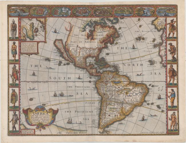
Auction 161, Lot 59
Subject: Western Hemisphere - America
Speed, John
America with Those Known Parts in That Unknowne Worlde Both People and Manner of Buildings Discribed and Inlarged, 1626
Size: 19.9 x 15.3 inches (50.5 x 38.9 cm)
Estimate: $7,000 - $8,500
Speed's Popular Carte-a-Figures Map of the Americas - First State
Sold for: $6,000
Closed on 2/8/2017
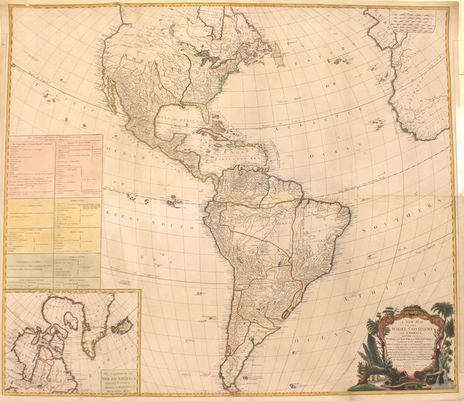
Auction 161, Lot 74
Subject: Western Hemisphere - America
Sayer, Robert
A New Map of the Whole Continent of America, Divided Into North and South and West Indies ... Wherein Are Exactly Described the United States of North America..., 1786
Size: 46.5 x 40.7 inches (118.1 x 103.4 cm)
Estimate: $2,000 - $2,400
Impressive Four-Sheet Map Featuring the New United States and Two Possible Locations for a River of the West
Sold for: $1,000
Closed on 2/8/2017
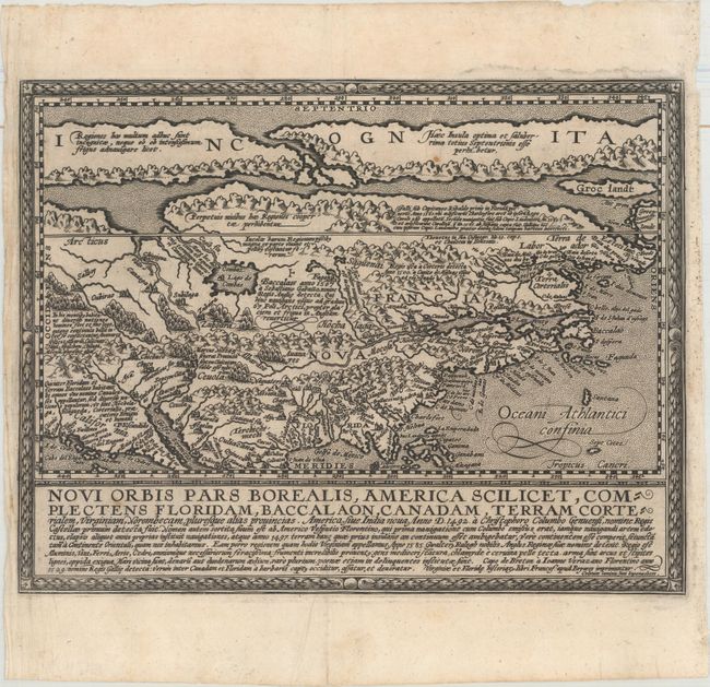
Auction 161, Lot 83
Subject: Colonial North America
Quad, Matthias von Kinckelbach
Novi Orbis pars Borealis, America Scilicet, Complectens Floridam, Baccalaon, Canadam, Terram Corterialem..., 1600
Size: 11.7 x 9 inches (29.7 x 22.9 cm)
Estimate: $2,750 - $3,500
One of the Earliest Maps Devoted to North America
Sold for: $2,000
Closed on 2/8/2017
Auction 161, Lot 85
Subject: Colonial North America
Hondius/Jansson
America Septentrionalis, 1644
Size: 21.8 x 18.3 inches (55.4 x 46.5 cm)
Estimate: $2,750 - $3,500
One of the Most Important Maps Perpetuating the Myth of the Island of California
Sold for: $2,000
Closed on 2/8/2017
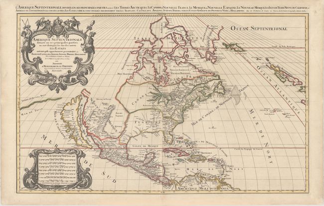
Auction 161, Lot 87
Subject: Colonial North America
Sanson/Mortier
Amerique Septentrionale Divisee en ses Principales Parties, ou sont Distingues les uns des Autres les Estats..., 1700
Size: 34.3 x 21.4 inches (87.1 x 54.4 cm)
Estimate: $2,500 - $3,250
Sanson's Two-Sheet Map Showing the Island of California
Sold for: $1,400
Closed on 2/8/2017
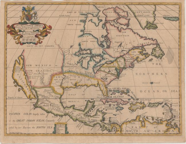
Auction 161, Lot 91
Subject: Colonial North America
Wells, Edward
A New Map of North America Shewing its Principal Divisions, Chief Cities, Townes, Rivers, Mountains, &c., 1704
Size: 19.3 x 14.5 inches (49 x 36.8 cm)
Estimate: $1,400 - $1,700
Wells' Map of North America Featuring California as an Island
Unsold
Closed on 2/8/2017
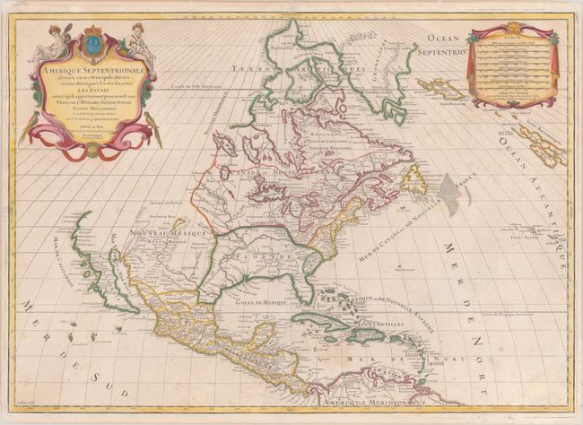
Auction 161, Lot 92
Subject: Colonial North America
Sanson/Jaillot
Amerique Septentrionale Divisee en Ses Principales Parties..., 1719
Size: 25.5 x 18.2 inches (64.8 x 46.2 cm)
Estimate: $1,400 - $1,700
Fifth State of Sanson/Jaillot's Map of North America
Unsold
Closed on 2/8/2017
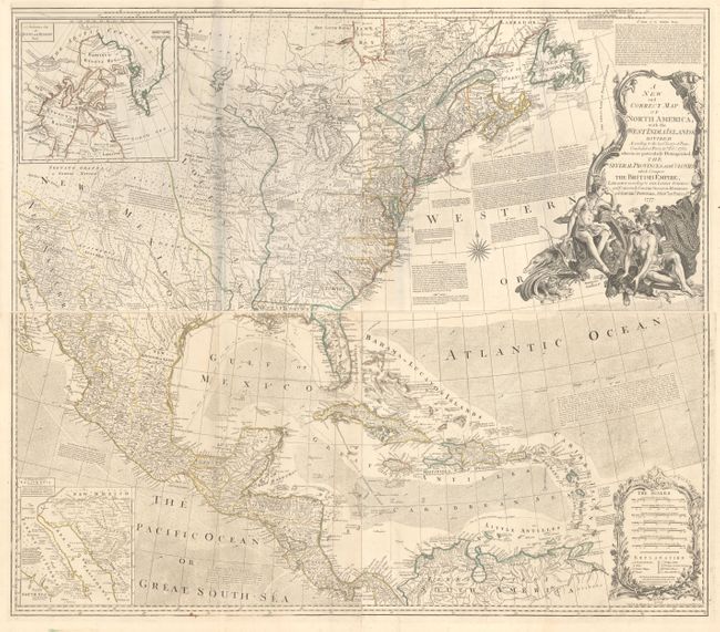
Auction 161, Lot 104
Subject: Colonial North America
Bowen & Gibson
[On 4 Sheets] A New and Correct Map of North America, with the West India Islands. Divided According to the Last Treaty of Peace..., 1777
Size: 45.8 x 20 inches (116.3 x 50.8 cm)
Estimate: $5,000 - $6,500
Bowen & Gibson's Large and Influential Map of North America
Unsold
Closed on 2/8/2017
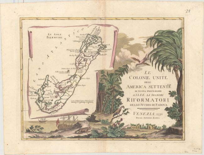
Auction 161, Lot 106
Subject: North America
Zatta, Antonio
[Complete Set of 12] Le Colonie Unite dell' America Settentrle. di Nuova Projezione..., 1791
Size: 16.8 x 12.6 inches (42.7 x 32 cm)
Estimate: $4,000 - $5,000
Impressive 12-Sheet Map of the New "United Colonies"
Unsold
Closed on 2/8/2017
Auction 161, Lot 120
Subject: Colonial Eastern North America & West Indies
Popple/Covens & Mortier
A Map of the British Empire in America with the French, Spanish and the Dutch Settlements Adjacent Thereto, 1741
Size: 18.9 x 19.3 inches (48 x 49 cm)
Estimate: $2,750 - $3,500
Index Sheet of Popple's Map
Sold for: $2,100
Closed on 2/8/2017
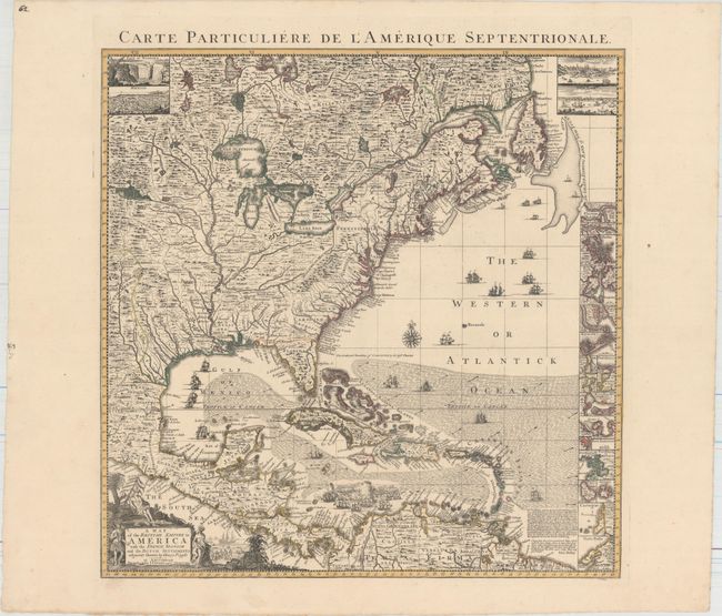
Auction 161, Lot 128
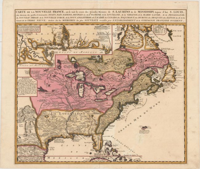
Subject: Colonial Eastern United States & Canada
Chatelain, Henry Abraham
Carte de la Nouvelle France, ou se voit le Cours des Grandes Rivieres de S. Laurens & de Mississipi Aujour d'hui S. Louis, aux Environs des-quelles se Trouvent les Etats, Pais, Nations, Peuples &c..., 1719
Size: 19.3 x 16.6 inches (49 x 42.2 cm)
Estimate: $3,000 - $3,750
One of the Most Informative 18th Century Maps of the French Possessions in North America
Sold for: $2,200
Closed on 2/8/2017
Auction 161, Lot 129
Subject: Colonial Eastern United States & Canada
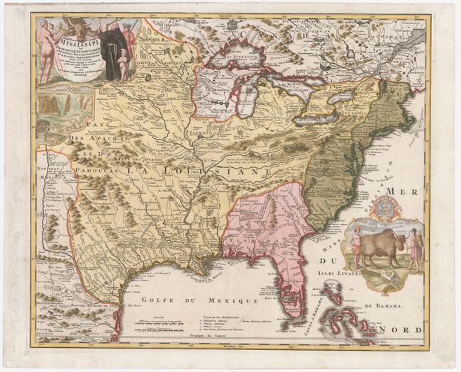
Homann, Johann Baptist
Amplissimae Regionis Mississipi seu Provinciae Ludovicianae a R.P. Ludovico Hennepin Francisc Miss in America Septentrionali Anno 1687..., 1720
Size: 22.6 x 19.1 inches (57.4 x 48.5 cm)
Estimate: $2,200 - $2,500
Striking Map of Colonial America with Buffalo Vignette
Sold for: $2,300
Closed on 2/8/2017
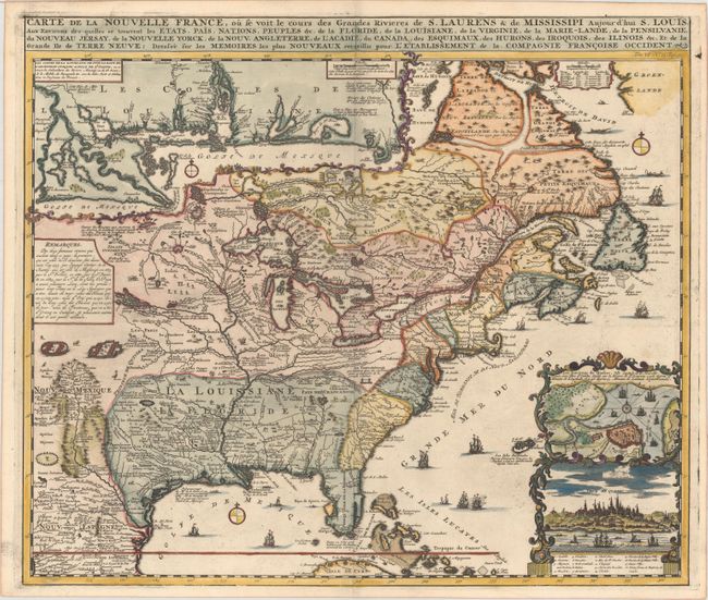
Auction 161, Lot 131
Subject: Colonial Eastern United States & Canada
Ottens/De Fer
Carte de la Nouvelle France, ou se voit le Cours des Grandes Rivieres de S. Laurens & de Mississipi Aujour d'hui S. Louis, aux Environs des-quelles se Trouvent les Etats, Pais, Nations, Peuples &c..., 1745
Size: 21.8 x 19.7 inches (55.4 x 50 cm)
Estimate: $2,300 - $2,750
Reduced Version of De Fer's Influential Map of French Possessions in North America
Sold for: $1,200
Closed on 2/8/2017
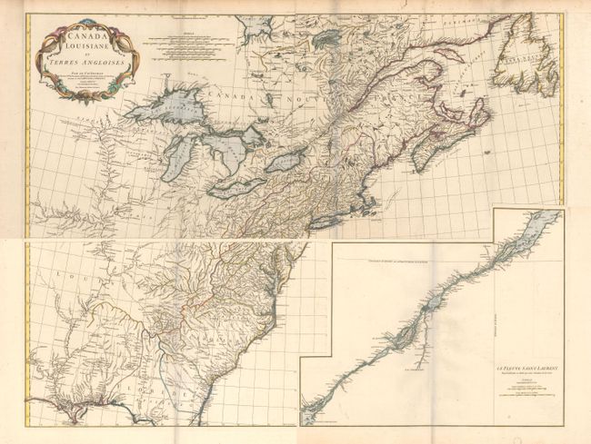
Auction 161, Lot 132
Subject: Colonial Eastern United States & Canada
Anville, Jean Baptiste Bourguignon d'
[On 4 Sheets] Canada Louisiane et Terres Angloises, 1755
Size: 44.5 x 18.8 inches (113 x 47.8 cm)
Estimate: $1,600 - $2,000
D'Anville's Spectacular Map of Eastern Seaboard
Sold for: $800
Closed on 2/8/2017
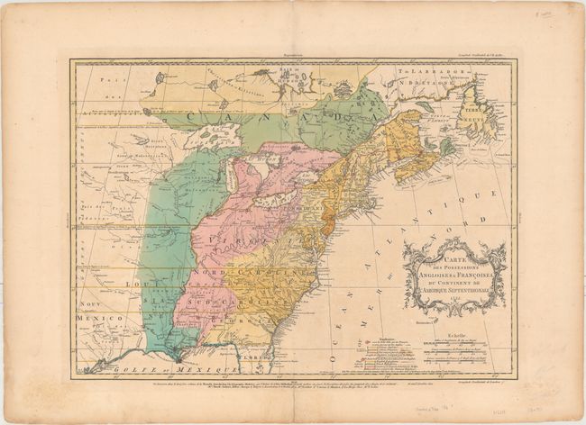
Auction 161, Lot 133
Subject: Colonial Eastern United States & Canada
Palairet, Jean
Carte des Possessions Angloises & Francoises du Continent de l'Amerique Septentrionale, 1755
Size: 22.7 x 16.4 inches (57.7 x 41.7 cm)
Estimate: $2,400 - $3,000
Important Map of French and English Territorial Claims at the Outset of the French and Indian War
Unsold
Closed on 2/8/2017
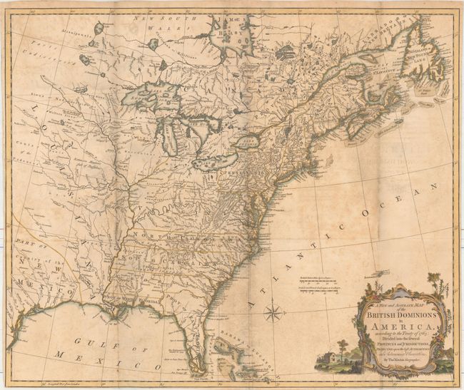
Auction 161, Lot 137
Subject: Colonial Eastern United States & Canada
Kitchin, Thomas
A New and Accurate Map of the British Dominions in America, According to the Treaty of 1763; Divided into the Several Provinces and Jurisdictions..., 1769
Size: 24.6 x 20.6 inches (62.5 x 52.3 cm)
Estimate: $1,400 - $1,700
Rare Map of the British Colonies Just After the French & Indian War
Sold for: $800
Closed on 2/8/2017
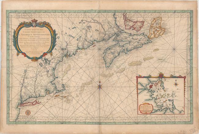
Auction 161, Lot 145
Subject: Colonial Northeastern United States & Canada
Bellin, Jacques Nicolas
Carte Reduite des Costes Orientales de l'Amerique Septentrionale 1re. Feuille Contenant l'Isle Royale, l'Accadie, la Bay Francoise, la Nouvelle Angleterre et la Nouvelle Yorc..., 1757
Size: 34.9 x 21.6 inches (88.6 x 54.9 cm)
Estimate: $1,700 - $2,000
Scarce Large-Scale Chart of the Coast of New England
Sold for: $1,200
Closed on 2/8/2017
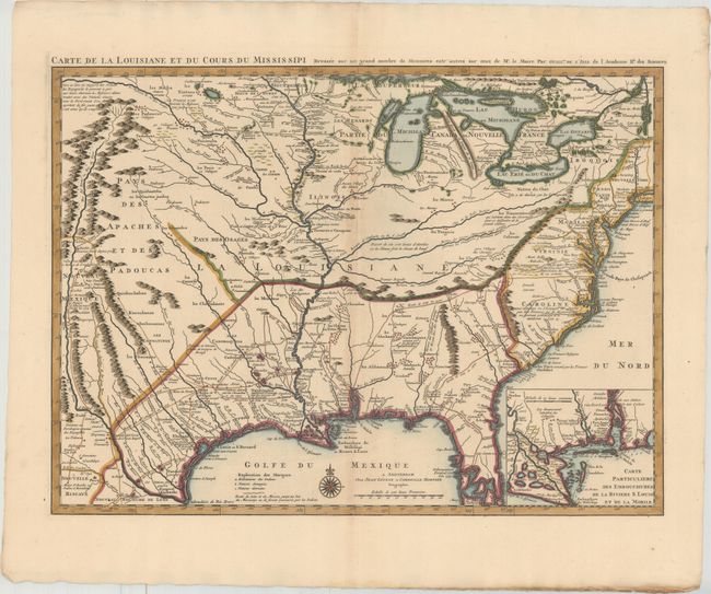
Auction 161, Lot 163
Subject: Colonial Eastern United States, Louisiana Territory
Delisle/Covens & Mortier
Carte de la Louisiane et du Cours du Mississipi Dressee sur un Grand Nombre de Memoires Entr'autres sur ceux de Mr. le Maire, 1730
Size: 23.7 x 17.3 inches (60.2 x 43.9 cm)
Estimate: $2,400 - $3,000
Delisle's Influential Map of the Louisiana Territory
Unsold
Closed on 2/8/2017
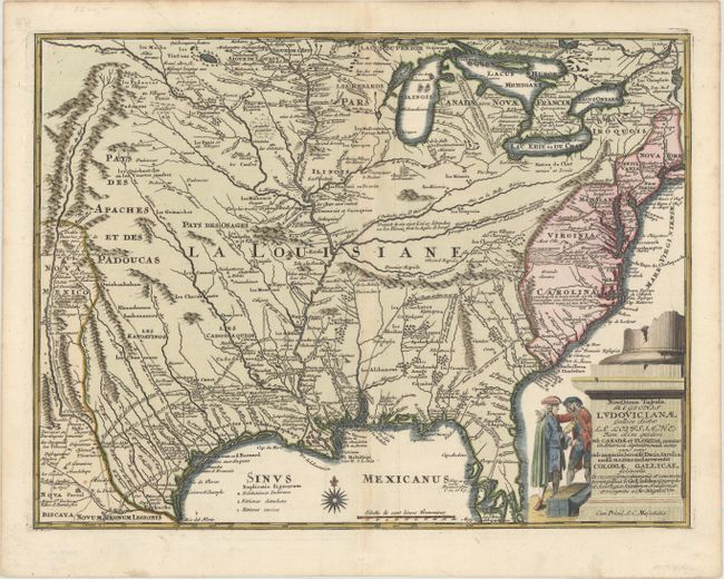
Auction 161, Lot 164
Subject: Colonial Eastern United States
Weigel, Christopher
Novissima Tabula Regionis Ludovicianae Gallice Dictae la Louisiane tam olim Quidem sub Canadae et Floridae Nomine in America Septentrionali..., 1734
Size: 16.5 x 12.5 inches (41.9 x 31.8 cm)
Estimate: $1,400 - $1,700
Uncommon Map of French Louisiana with a Title Cartouche Referencing the Mississippi Bubble Scheme
Unsold
Closed on 2/8/2017
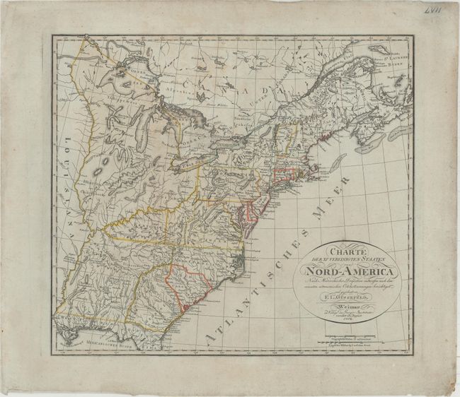
Auction 161, Lot 167
Subject: Eastern United States
Gussefeld, Franz Ludwig
Charte der XV Vereinigten Staaten von Nord-America nach Murdochischer Projection..., 1804
Size: 20.7 x 18.4 inches (52.6 x 46.7 cm)
Estimate: $1,200 - $1,500
Map Depicting the Proposed State of Franklin
Sold for: $900
Closed on 2/8/2017
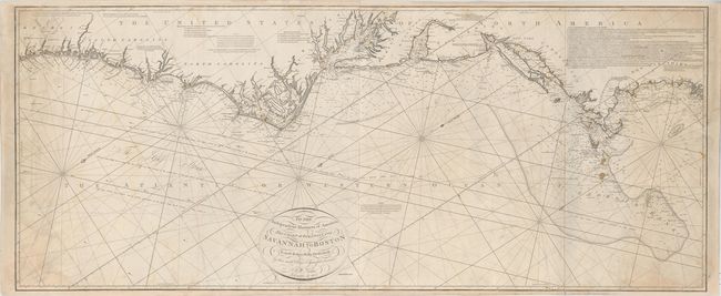
Auction 161, Lot 171
Subject: Eastern United States
Norie, John William
To the Independent Mariners of America, This Chart of their Coast from Savannah to Boston is most Respectfully Dedicated…, 1852
Size: 61 x 25.3 inches (154.9 x 64.3 cm)
Estimate: $2,000 - $2,300
Rare Blue-Back Chart of the East Coast
Unsold
Closed on 2/8/2017
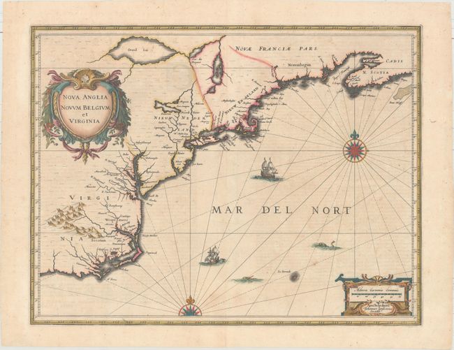
Auction 161, Lot 174
Subject: Colonial New England & Mid-Atlantic
Jansson, Jan
Nova Anglia Novum Belgium et Virginia, 1639
Size: 19.9 x 15.3 inches (50.5 x 38.9 cm)
Estimate: $1,600 - $1,900
Jansson's Influential Map of the East Coast
Sold for: $1,000
Closed on 2/8/2017
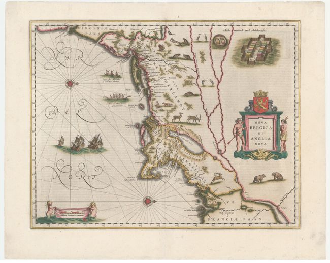
Auction 161, Lot 175
Subject: Colonial New England & Mid-Atlantic
Blaeu, Willem
Nova Belgica et Anglia Nova, 1642
Size: 19.9 x 15.3 inches (50.5 x 38.9 cm)
Estimate: $3,000 - $4,000
Important Map of Colonial New England and the Mid-Atlantic
Sold for: $2,000
Closed on 2/8/2017
Auction 161, Lot 176
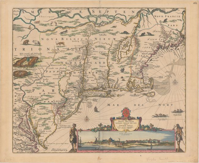
Subject: Colonial New England & Mid-Atlantic United States
Visscher, Nicolas
Novi Belgii Novaeque Angliae nec non Partis Virginiae Tabula Multis in Locis Emendata, 1684
Size: 21.9 x 18.4 inches (55.6 x 46.7 cm)
Estimate: $7,500 - $9,000
Visscher's Influential Map with Early View of New York City
Unsold
Closed on 2/8/2017
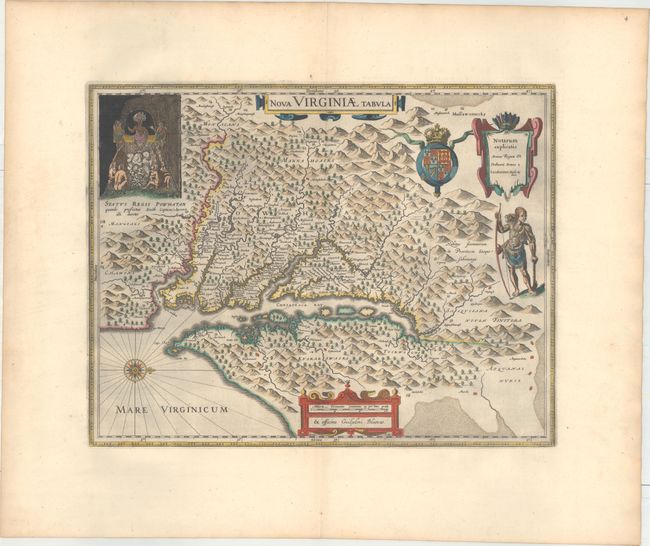
Auction 161, Lot 183
Subject: Colonial Mid-Atlantic United States
Hondius/Blaeu
Nova Virginiae Tabula, 1663
Size: 18.9 x 14.8 inches (48 x 37.6 cm)
Estimate: $2,400 - $3,000
One of the Most Important 17th Century Maps of the Chesapeake Bay in Full Original Color
Sold for: $1,400
Closed on 2/8/2017
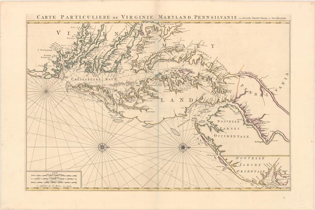
Auction 161, Lot 185
Subject: Colonial Mid-Atlantic United States
Jaillot/Mortier
Carte Particuliere de Virginie, Maryland, Pennsilvanie, la Nouvelle Iarsey. Orient et Occidentale, 1700
Size: 31.8 x 20.6 inches (80.8 x 52.3 cm)
Estimate: $6,000 - $7,500
One of the Most Beautiful Charts of Maryland and the Chesapeake Bay
Sold for: $11,000
Closed on 2/8/2017
Auction 161, Lot 187
Subject: Colonial Mid-Atlantic United States
Aa, Pieter van der
Virginie, Grande Region de l'Amerique Septentrionale, avec tous Ses Bourgs, Hameaux, Rivieres et Bayes..., 1729
Size: 14.1 x 11.4 inches (35.8 x 29 cm)
Estimate: $1,800 - $2,100
Rare Derivative of John Smith's Map of the Chesapeake Bay
Unsold
Closed on 2/8/2017
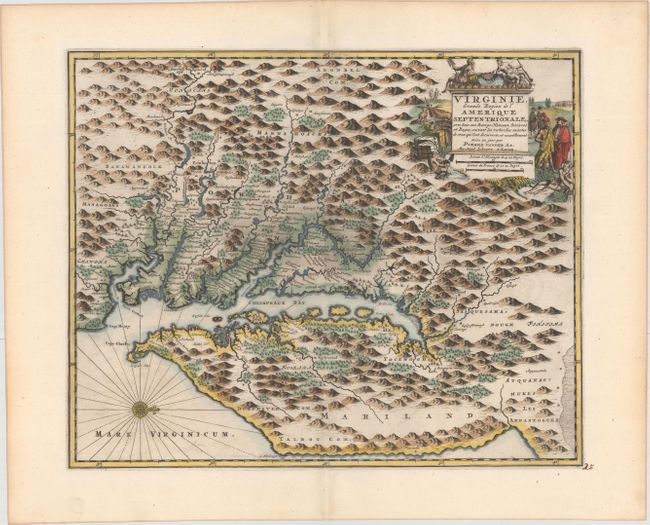
Auction 161, Lot 188
Subject: Colonial Mid-Atlantic United States
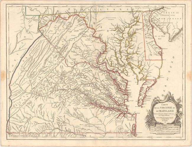
Robert de Vaugondy, Didier
Carte de la Virginie et du Maryland Dressee sur la Grande Carte Angloise de Mrs. Josue Fry et Pierre Jefferson, 1755
Size: 25.1 x 19 inches (63.8 x 48.3 cm)
Estimate: $2,400 - $3,000
First State of Robert de Vaugondy's Essential Map of Virginia and Maryland
Sold for: $1,800
Closed on 2/8/2017
Auction 161, Lot 191
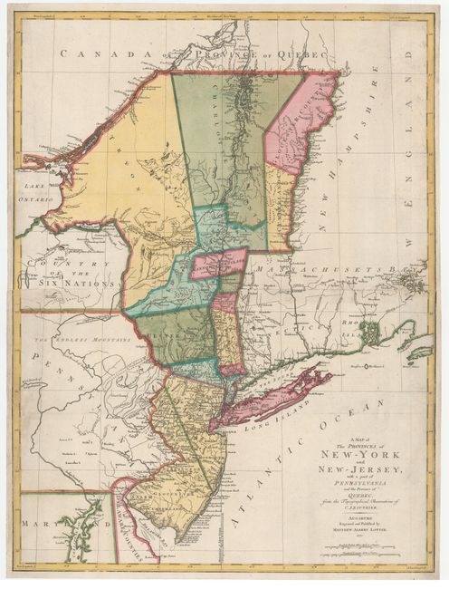
Subject: Colonial Mid-Atlantic United States
Lotter, Mathias Albrecht
A Map of the Provinces of New-York and New-Jersey, with a part of Pennsylvania and the Province of Quebec, from the Topographical Observations of C. J. Sauthier, 1777
Size: 22.1 x 29.5 inches (56.1 x 74.9 cm)
Estimate: $1,900 - $2,200
Important Revolutionary War Map
Sold for: $1,100
Closed on 2/8/2017
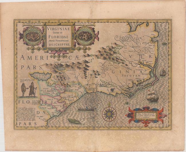
Auction 161, Lot 197
Subject: Colonial Southeast United States
Hondius, Jodocus
Virginiae Item et Floridae Americae Provinciarum, Nova Descriptio, 1619
Size: 19.1 x 13.5 inches (48.5 x 34.3 cm)
Estimate: $1,600 - $1,900
A Seminal Map of the Southeast and Early American Cartography - Full Original Color
Unsold
Closed on 2/8/2017
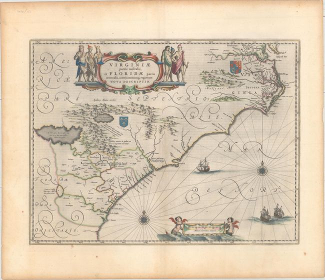
Auction 161, Lot 198
Subject: Colonial Southeast United States
Blaeu, Willem
Virginiae Partis Australis, et Floridae Partis Orientalis, Interjacentiumq Regionum Nova Descriptio, 1642
Size: 20 x 15.3 inches (50.8 x 38.9 cm)
Estimate: $1,600 - $1,900
Blaeu's Decorative Map of the Southeast in Full Original Color
Unsold
Closed on 2/8/2017
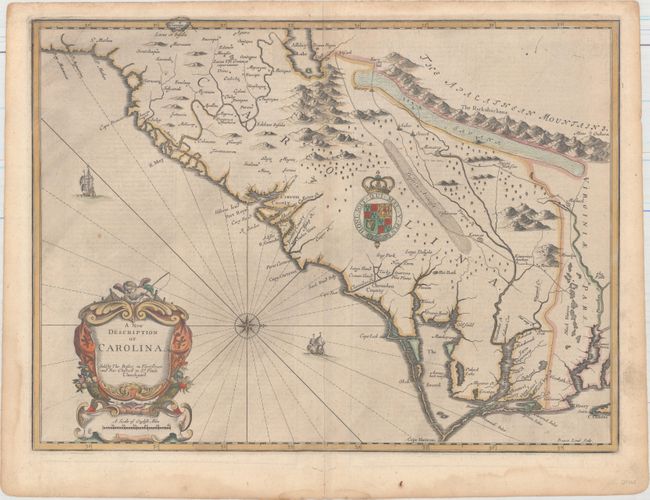
Auction 161, Lot 199
Subject: Colonial Southeastern United States
Speed/Lamb
A New Description of Carolina, 1676
Size: 20 x 14.8 inches (50.8 x 37.6 cm)
Estimate: $4,000 - $5,000
Speed's Map of the Carolinas Based Upon the Lords Proprietor's Map
Unsold
Closed on 2/8/2017
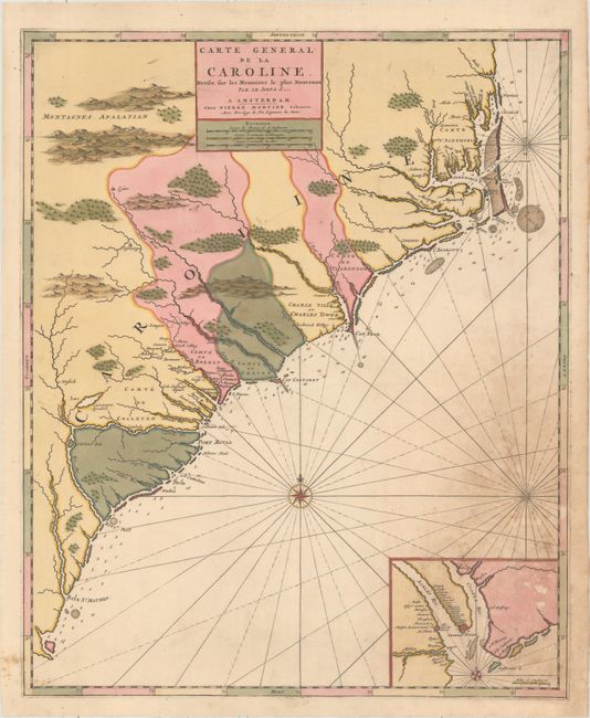
Auction 161, Lot 200
Subject: Colonial Southeast United States
Mortier, Pierre
Carte General de la Caroline. Dresse sur les Memoires le Plus Nouveaux par le Sieua S..., 1700
Size: 18.3 x 22.4 inches (46.5 x 56.9 cm)
Estimate: $1,500 - $1,800
The First Map of the Carolinas Published Outside of England
Sold for: $750
Closed on 2/8/2017
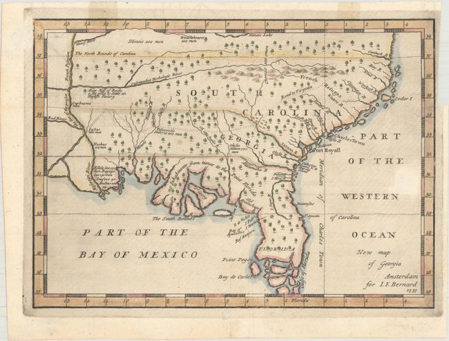
Auction 161, Lot 201
Subject: Colonial Southeast United States
Bernard, Jean Frederic
New Map of Georgia, 1737
Size: 10.3 x 7.5 inches (26.2 x 19.1 cm)
Estimate: $1,400 - $1,700
One of the Earliest Published Maps of the English Colony of Georgia
Sold for: $1,300
Closed on 2/8/2017
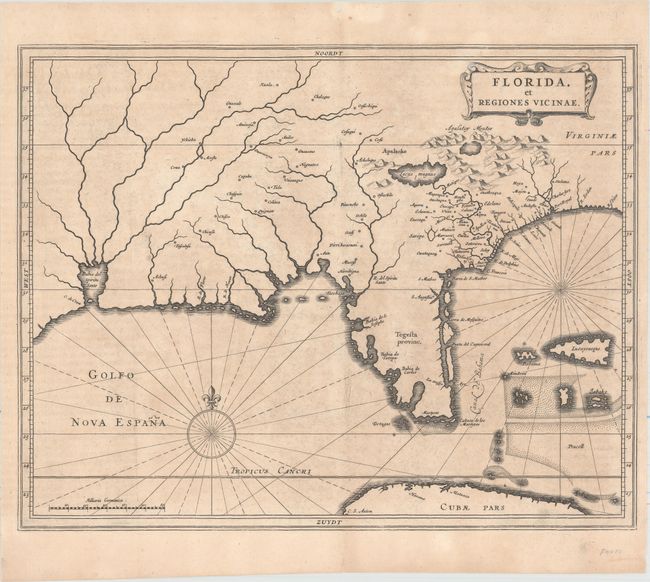
Auction 161, Lot 211
Subject: Colonial Southern United States
Gerritsz/De Laet
Florida, et Regiones Vicinae, 1630
Size: 14 x 11.3 inches (35.6 x 28.7 cm)
Estimate: $3,000 - $3,750
De Laet's Important Map of the South
Sold for: $2,200
Closed on 2/8/2017
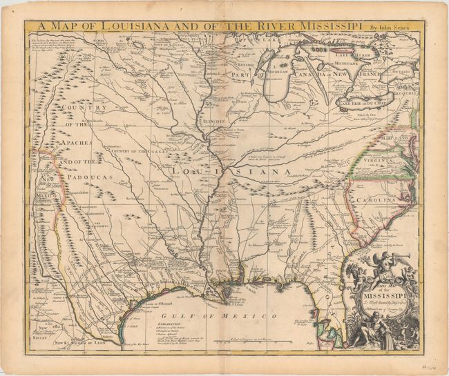
Auction 161, Lot 228
Subject: Colonial South Central United States, Louisiana
Senex, John
A Map of Louisiana and of the River Mississipi, 1721
Size: 22.8 x 19.2 inches (57.9 x 48.8 cm)
Estimate: $2,750 - $3,500
Important Map of Colonial Louisiana and the Mississippi River
Sold for: $1,800
Closed on 2/8/2017
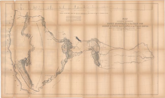
Auction 161, Lot 244
Subject: Western United States
Fremont/Preuss
Map of an Exploring Expedition to the Rocky Mountains in the Year 1842 and to Oregon & North California in the Years 1843-44 [with] Report of The Exploring Expedition to the Rocky Mountains…, 1845
Size: 51 x 30.5 inches (129.5 x 77.5 cm)
Estimate: $1,000 - $1,300
Fremont's Large Map of the American West
Unsold
Closed on 2/8/2017
95 lots
Page 1 of 2