Showing Featured Lots(remove filter)
Filtered by Category:World, Polar, Celestial, Globes(Show All Categories)
Showing results for:Auction 173
Catalog Archive
11 lots
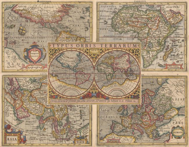
Auction 173, Lot 11
Subject: World & Continents
Mercator/Hondius
[Lot of 5] Typus Orbis Terrarum [and] America Descrip. [and] Africae Descriptio [and] Asia [and] Europa, 1613
Size: 7.9 x 5.3 inches (20.1 x 13.5 cm)
Estimate: $2,400 - $3,000
Matching Set from 2nd French Edition of the Atlas Minor
Sold for: $1,800
Closed on 6/5/2019
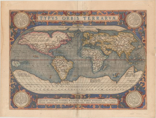
Auction 173, Lot 13
Subject: World
Ortelius, Abraham
Typus Orbis Terrarum, 1587
Size: 19.3 x 14 inches (49 x 35.6 cm)
Estimate: $5,500 - $6,500
Ortelius' Third World Map in an Oval Projection
Sold for: $3,500
Closed on 6/5/2019
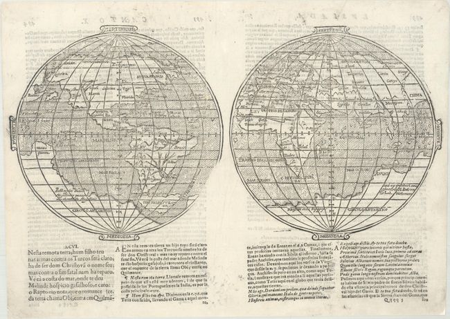
Auction 173, Lot 14
Subject: World
Camoens, Luis de
[Untitled - World], 1639
Size: 15.6 x 7.8 inches (39.6 x 19.8 cm)
Estimate: $4,750 - $6,000
A Scarce Spanish World Map
Unsold
Closed on 6/5/2019
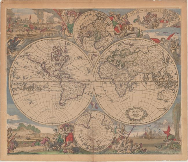
Auction 173, Lot 16
Subject: World
Danckerts, Justus
Nova Totius Terrarum Orbis Tabula, 1685
Size: 23 x 19.2 inches (58.4 x 48.8 cm)
Estimate: $3,750 - $4,500
Danckerts' Decorative Double-Hemisphere Map in Contemporary Color
Sold for: $2,750
Closed on 6/5/2019
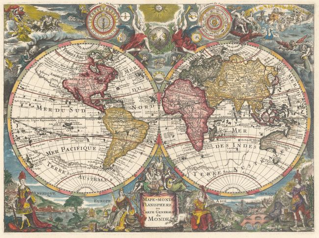
Auction 173, Lot 17
Subject: World
Anon.
Mape-Monde Planisphere, ou Carte Generale du Monde, 1700
Size: 13.4 x 9.9 inches (34 x 25.1 cm)
Estimate: $2,400 - $3,000
Uncommon Map with Superb Embellishments
Sold for: $2,200
Closed on 6/5/2019
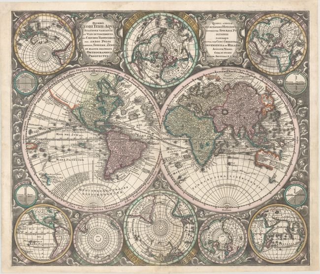
Auction 173, Lot 22
Subject: World
Seutter, Matthias
Diversi Globi Terr-Aquei Statione Variante et Visu Intercedente, per Coluros Tropicorum..., 1742
Size: 22.9 x 19.7 inches (58.2 x 50 cm)
Estimate: $2,200 - $2,500
One of the Most Graphic 18th Century World Maps
Sold for: $2,100
Closed on 6/5/2019
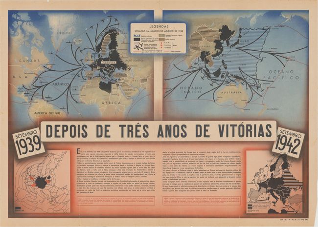
Auction 173, Lot 28
Subject: World, World War II
Anon.
Depois de Tres Anos de Vitorias, 1942
Size: 31.4 x 21.8 inches (79.8 x 55.4 cm)
Estimate: $475 - $600
Portuguese Propaganda Map Supporting the Axis in WWII
Sold for: $350
Closed on 6/5/2019
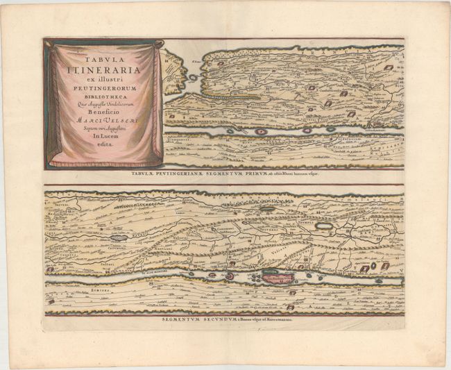
Auction 173, Lot 31
Subject: Ancient World
Jansson, Jan
[On 4 Sheets] Tabula Itineraria ex Illustri Peutingerorum Bibliotheca quae Augustae Vindelicorum Beneficio Marci Velseri Septem-Viri Augustani in Lucem Edita, 1741
Size: 19.8 x 15.4 inches (50.3 x 39.1 cm)
Estimate: $2,400 - $3,000
Famous Peutinger Table
Unsold
Closed on 6/5/2019
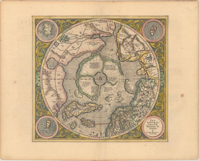
Auction 173, Lot 33
Subject: North Pole
Mercator/Hondius
Septentrionalium Terrarum Descriptio, 1619
Size: 15.6 x 14.5 inches (39.6 x 36.8 cm)
Estimate: $2,200 - $2,500
The First Printed Map Devoted to the Arctic
Sold for: $1,600
Closed on 6/5/2019
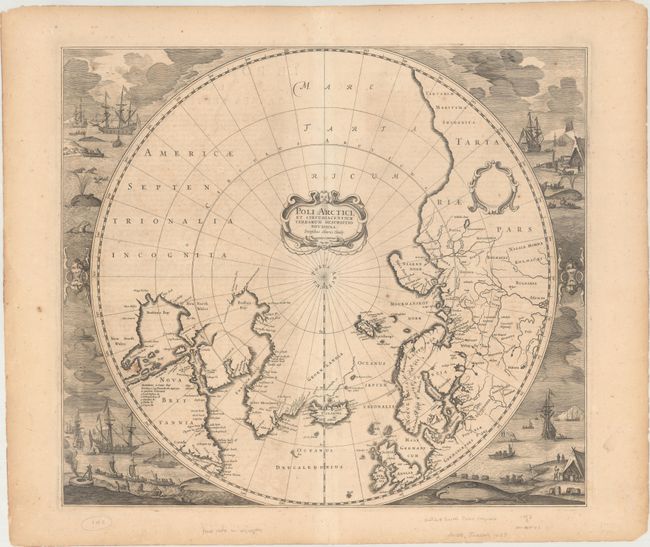
Auction 173, Lot 34
Subject: Polar
Hondius, Henricus
[Lot of 2] Poli Arctici, et Circumiacentium Terrarum Descriptio Novissima [and] Polus Antarcticus, 1639
Size: 19.4 x 17 inches (49.3 x 43.2 cm)
Estimate: $3,000 - $4,000
Magnificent Polar Maps Surrounded by Engraved Scenes
Unsold
Closed on 6/5/2019
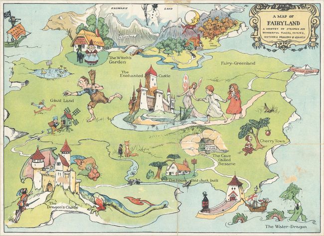
Auction 173, Lot 41
Subject: Cartographic Miscellany
A Map of Fairyland - A Country of Strange and Wonderful Places, Fairies, Witches Dragons & Giants [with] The Magic Map Book, 1909
Size: 14.6 x 10.6 inches (37.1 x 26.9 cm)
Estimate: $300 - $400
A Fantastical Pictorial Map for Children
Sold for: $150
Closed on 6/5/2019
11 lots