Showing Featured Lots(remove filter)
Filtered by Category:United States(Show All Categories)
Showing results for:Auction 191
Catalog Archive
12 lots
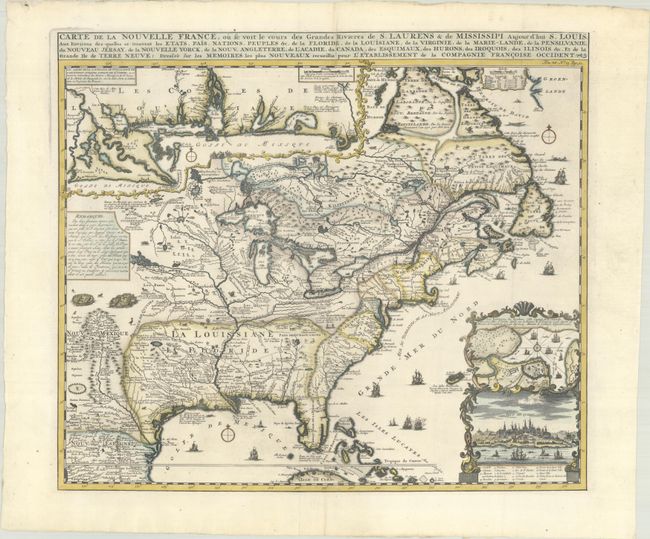
Auction 191, Lot 128
Subject: Colonial Eastern United States & Canada
Chatelain, Henry Abraham
Carte de la Nouvelle France, ou se Voit le Cours des Grandes Rivieres de S. Laurens & de Mississipi Aujour d'hui S. Louis, aux Environs des-quelles se Trouvent les Etats, Pais, Nations, Peuples &c. de la Floride..., 1720
Size: 19.1 x 16.6 inches (48.5 x 42.2 cm)
Estimate: $3,000 - $3,750
One of the Most Informative 18th Century Maps of the French Possessions in North America
Sold for: $3,000
Closed on 2/8/2023
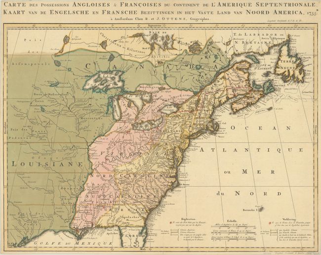
Auction 191, Lot 129
Subject: Colonial Eastern United States & Canada
Ottens, Reiner and Joshua
Carte des Possessions Angloises & Francoises du Continent de l'Amerique Septentrionale / Kaart van de Engelsche en Fransche Bezittingen in het Vaste Land van Noord America, 1755
Size: 22.4 x 16.3 inches (56.9 x 41.4 cm)
Estimate: $1,400 - $1,700
Dutch Version of an Important Map Showing Territorial Claims at the Outset of the French and Indian War
Sold for: $1,000
Closed on 2/8/2023
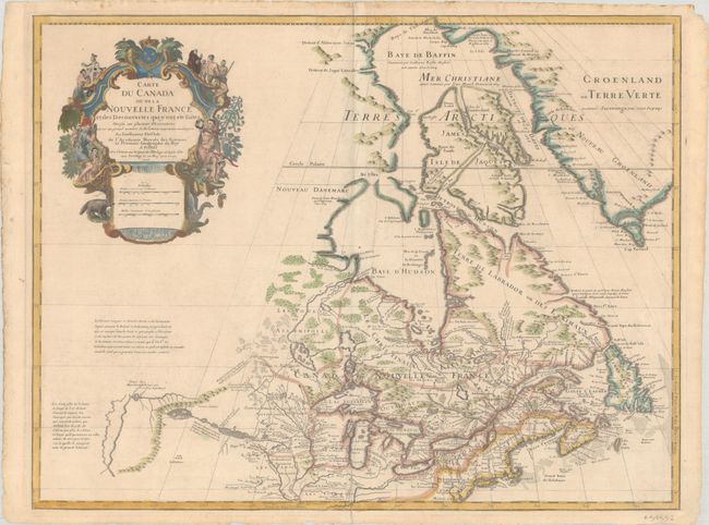
Auction 191, Lot 134
Subject: Colonial Northeastern United States & Canada, Great Lakes
Delisle, Guillaume
Carte du Canada ou de la Nouvelle France et des Decouvertes qui y ont ete Faites Dressee sur Plusieurs Observations et sur un Grand Nombre de Relations Imprimees ou Manuscrites..., 1703
Size: 25.6 x 19.6 inches (65 x 49.8 cm)
Estimate: $1,900 - $2,200
Delisle's Seminal Map of Canada and the Great Lakes
Sold for: $1,400
Closed on 2/8/2023
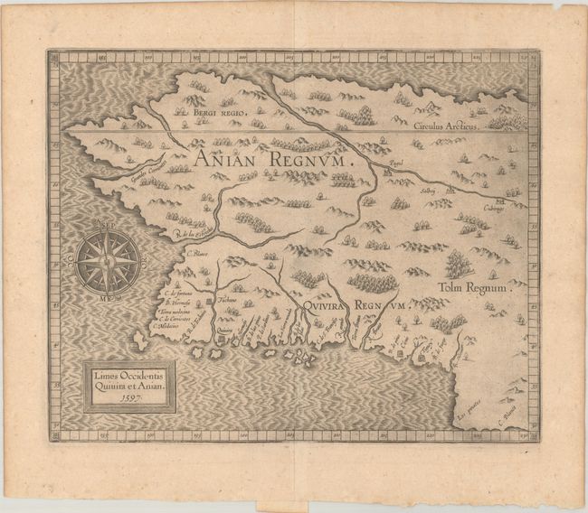
Auction 191, Lot 141
Subject: Alaska & Western Canada
Wytfliet, Cornelis
Limes Occidentis Quivira et Anian, 1597
Size: 11.5 x 9.3 inches (29.2 x 23.6 cm)
Estimate: $1,900 - $2,200
Early and Imaginary Map of Alaska and the Northwest Passage
Sold for: $1,400
Closed on 2/8/2023
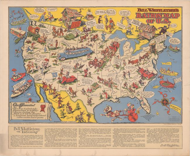
Auction 191, Lot 158
Subject: United States, World War II
[Lot of 2] Bill Whiffletree's Ration Map of U.S. [and] Bill Whiffletree's Bootleggers' Map of the United States, 1944
Size: 30.1 x 20.2 inches (76.5 x 51.3 cm)
Estimate: $3,000 - $4,000
Matching Pair Featuring the Extremely Rare "Ration Map"
Sold for: $2,000
Closed on 2/8/2023
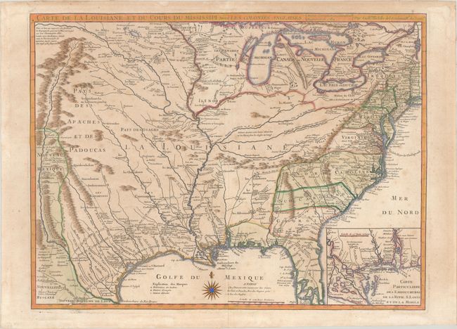
Auction 191, Lot 163
Subject: Colonial Eastern United States, Louisiana Territory
Delisle/Dezauche
Carte de la Louisiane et du Cours du Mississipi avec les Colonies Anglaises, 1782
Size: 25.5 x 19.2 inches (64.8 x 48.8 cm)
Estimate: $1,200 - $1,500
Dezauche Edition of Delisle's Influential Map of the Louisiana Territory
Sold for: $1,200
Closed on 2/8/2023
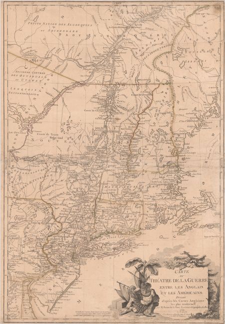
Auction 191, Lot 182
Subject: Colonial New England United States
Brion de la Tour, Louis
Carte du Theatre de la Guerre Entre les Anglais et les Americains: Dressee d'Apres les Cartes Anglaises les Plus Modernes, 1779
Size: 20.4 x 29.7 inches (51.8 x 75.4 cm)
Estimate: $4,000 - $5,000
Important Map Depicting Tipping Point of Revolutionary War
Unsold
Closed on 2/8/2023
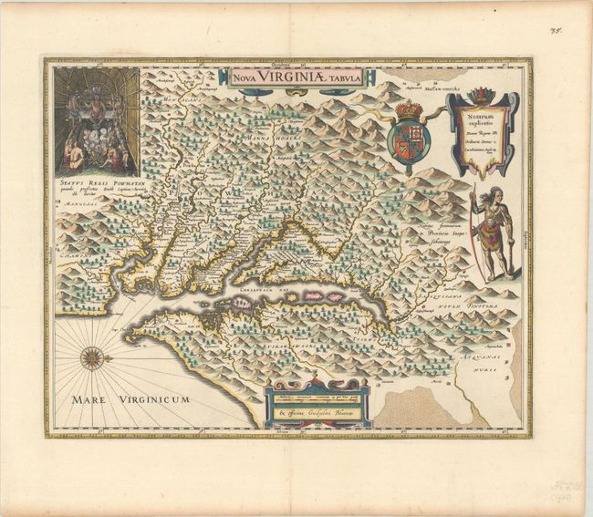
Auction 191, Lot 184
Subject: Colonial Mid-Atlantic United States
Hondius/Blaeu
Nova Virginiae Tabula, 1630
Size: 18.8 x 14.8 inches (47.8 x 37.6 cm)
Estimate: $2,000 - $2,300
One of the Most Important 17th Century Maps of the Chesapeake Bay
Sold for: $2,000
Closed on 2/8/2023
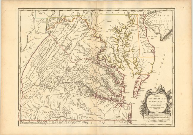
Auction 191, Lot 185
Subject: Colonial Mid-Atlantic United States
Robert de Vaugondy, Didier
Carte de la Virginie et du Maryland Dressee sur la Grande Carte Angloise de Mrs. Josue Fry et Pierre Jefferson..., 1755
Size: 25.2 x 19.1 inches (64 x 48.5 cm)
Estimate: $2,300 - $2,750
First State of Robert de Vaugondy's Essential Map of Virginia and Maryland
Sold for: $3,000
Closed on 2/8/2023
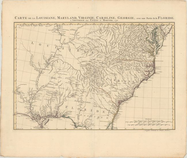
Auction 191, Lot 191
Subject: Colonial Southeastern United States
Covens & Mortier
Carte de la Louisiane, Maryland, Virginie, Caroline, Georgie, avec une Partie de la Floride, 1758
Size: 23.3 x 15.4 inches (59.2 x 39.1 cm)
Estimate: $1,100 - $1,400
Covens & Mortier's Map of the Southeast Issued During the French and Indian War
Sold for: $1,500
Closed on 2/8/2023
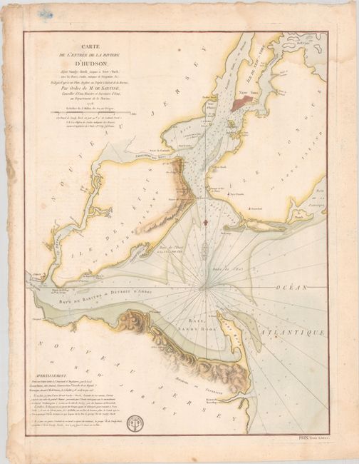
Auction 191, Lot 306
Subject: Colonial New York Harbor, Revolutionary War
Sartine
Carte de l'Entree de la Riviere d'Hudson, Depuis Sandy-Hook Jusques a New-York, avec les Bancs, Sondes, Marques de Navigation &c..., 1778
Size: 17.5 x 23.2 inches (44.5 x 58.9 cm)
Estimate: $1,600 - $1,900
Revolutionary War-Era Chart of New York Harbor Produced by the French Navy
Sold for: $1,200
Closed on 2/8/2023
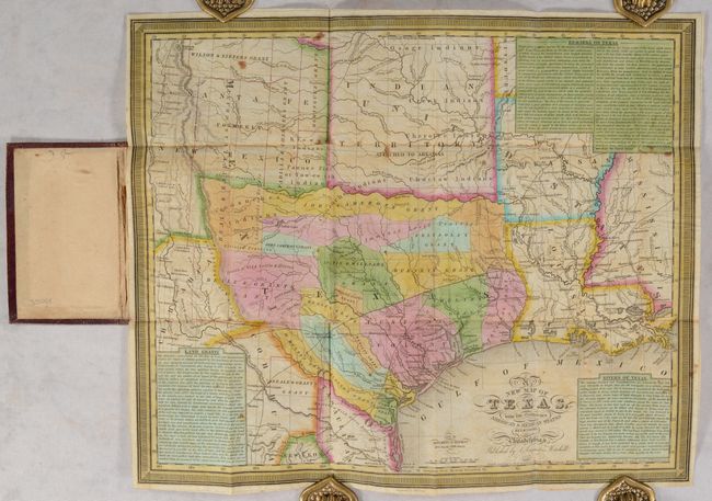
Auction 191, Lot 325
Subject: Texas
Mitchell, Samuel Augustus
A New Map of Texas, with the Contiguous American & Mexican States, 1837
Size: 15 x 12.4 inches (38.1 x 31.5 cm)
Estimate: $11,000 - $14,000
An Early and Important Map of the Republic of Texas
Sold for: $13,000
Closed on 2/8/2023
12 lots