Showing Featured Lots(remove filter)
Filtered by Category:United States(Show All Categories)
Showing results for:Auction 187
Catalog Archive
19 lots
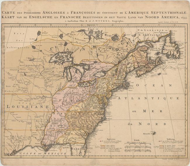
Auction 187, Lot 122
Subject: Colonial Eastern United States & Canada
Ottens, Reiner and Joshua
Carte des Possessions Angloises & Francoises du Continent de l'Amerique Septentrionale / Kaart van de Engelsche en Fransche Bezittingen in het Vaste Land van Noord America, 1755
Size: 22.4 x 16.3 inches (56.9 x 41.4 cm)
Estimate: $1,400 - $1,700
Dutch Version of an Important Map Showing Territorial Claims at the Outset of the French and Indian War
Sold for: $1,300
Closed on 4/27/2022
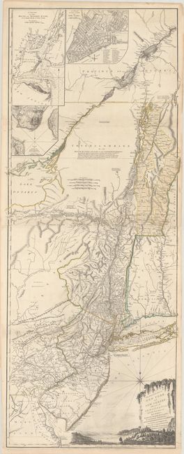
Auction 187, Lot 130
Subject: Colonial Northeastern United States & Quebec
Holland/Pownal
The Provinces of New York and New Jersey; with Part of Pensilvania, and the Province of Quebec, 1776
Size: 21.3 x 52.9 inches (54.1 x 134.4 cm)
Estimate: $4,000 - $4,750
Thomas Jefferys' Important Revolutionary War Period Map
Unsold
Closed on 4/27/2022
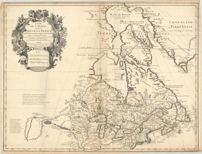
Auction 187, Lot 131
Subject: Colonial Northeastern United States & Canada, Great Lakes
Delisle, Guillaume
Carte du Canada ou de la Nouvelle France et des Decouvertes qui y ont ete Faites Dressee sur Plusieurs Observations et sur un Grand Nombre de Relations Imprimees ou Manuscrites, 1703
Size: 25.6 x 19.8 inches (65 x 50.3 cm)
Estimate: $3,000 - $3,750
Rare First State of Delisle's Seminal Map of Canada and the Great Lakes
Sold for: $4,750
Closed on 4/27/2022
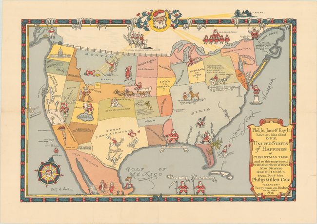
Auction 187, Lot 145
Subject: United States
Phil Jr., Jane & Kay Jr. Have an Idea About Our United States of Happiness at Christmas Time..., 1936
Size: 13.9 x 9.8 inches (35.3 x 24.9 cm)
Estimate: $600 - $800
Christmas Map Combining Santa and the American West, Commissioned by Philip Cole
Sold for: $475
Closed on 4/27/2022
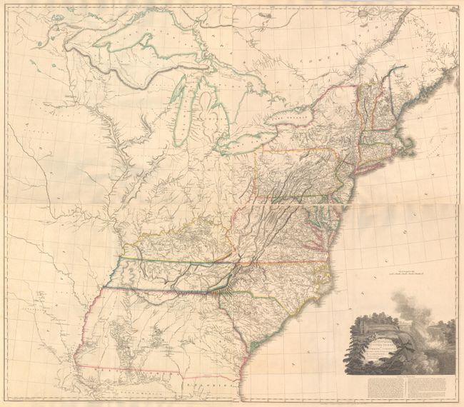
Auction 187, Lot 156
Subject: Eastern United States
Tardieu, Pierre Francois
[On 4 Sheets] United States of Nth America - Carte des Etats-Unis de l'Amerique Septentrionale Copiee et Gravee sur celle d'Arrowsmith..., 1802
Size: 55.2 x 49.2 inches (140.2 x 125 cm)
Estimate: $4,000 - $5,000
Rare French Edition of Arrowsmith's Influential Map of the United States
Sold for: $2,000
Closed on 4/27/2022
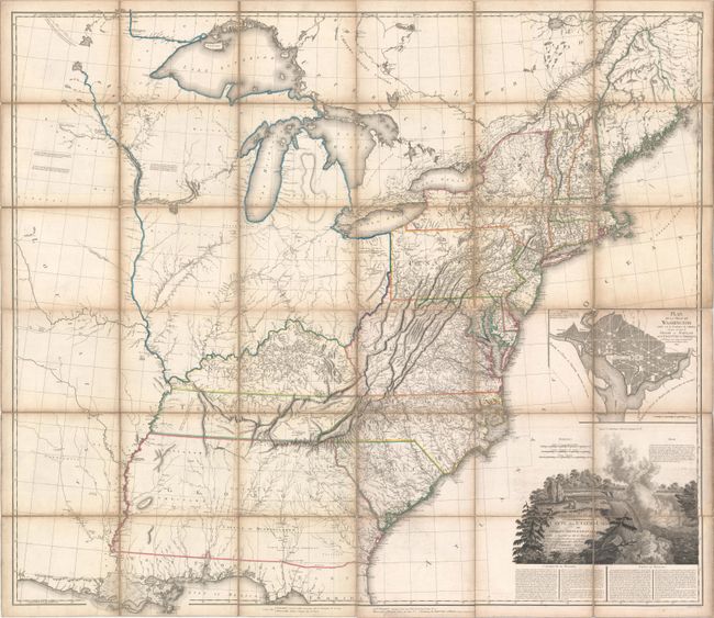
Auction 187, Lot 160
Subject: Eastern United States
Arrowsmith, Aaron, Sr.
[On 4 Sheets] A Map of the United States of North America Drawn from a Number of Critical Researches, 1815
Size: 27.8 x 24.3 inches (70.6 x 61.7 cm)
Estimate: $7,500 - $9,000
Large Format Map Used by Lewis & Clark
Unsold
Closed on 4/27/2022
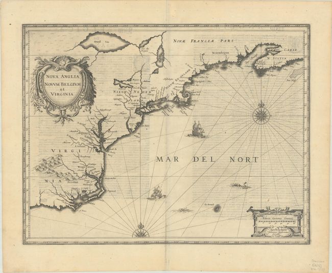
Auction 187, Lot 167
Subject: Colonial New England & Mid-Atlantic United States
Jansson, Jan
Nova Anglia Novum Belgium et Virginia, 1636
Size: 19.9 x 15.3 inches (50.5 x 38.9 cm)
Estimate: $1,100 - $1,400
Jansson's Influential Map of the East Coast
Sold for: $800
Closed on 4/27/2022
Auction 187, Lot 174
Subject: New England United States
Crevecoeur, Michel Guillaume De
[Three Volumes] Lettres d'un Cultivateur Americain Addressees a Wm. S... on Esqr. Depuis l'Annee 1770 Jusqu'en 1786..., 1787
Size: 5.1 x 8.1 inches (13 x 20.6 cm)
Estimate: $3,250 - $4,000
Crevecoeur's Classic Account on American Life
Sold for: $3,500
Closed on 4/27/2022
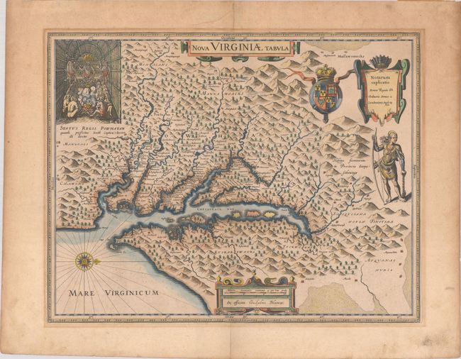
Auction 187, Lot 177
Subject: Colonial Mid-Atlantic United States
Hondius/Blaeu
Nova Virginiae Tabula, 1640
Size: 18.9 x 14.8 inches (48 x 37.6 cm)
Estimate: $1,800 - $2,100
One of the Most Important 17th Century Maps of the Chesapeake Bay
Sold for: $1,100
Closed on 4/27/2022
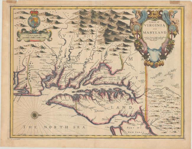
Auction 187, Lot 179
Subject: Colonial Mid-Atlantic United States
Speed/Lamb
A Map of Virginia and Maryland, 1676
Size: 19.4 x 14.9 inches (49.3 x 37.8 cm)
Estimate: $4,750 - $6,000
The First Printed Map to Draw Upon the Legendary Herrman Map of the Chesapeake Bay - Previously Owned by Coolie Verner
Unsold
Closed on 4/27/2022
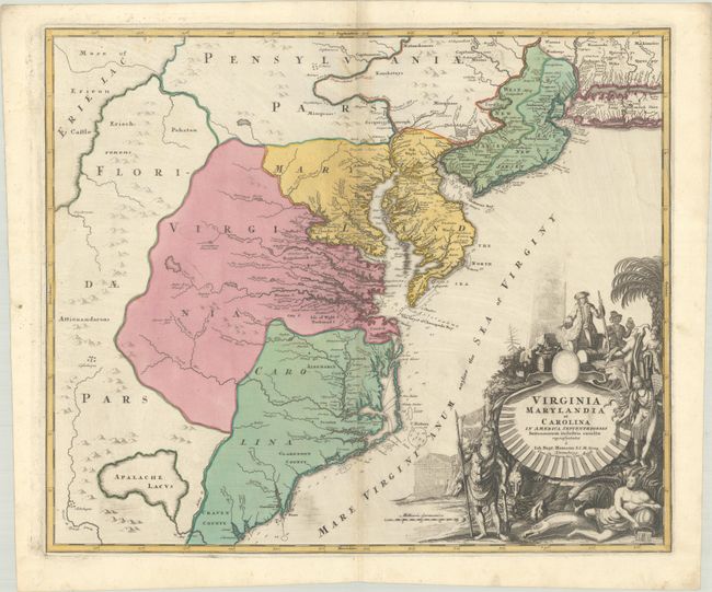
Auction 187, Lot 180
Subject: Colonial Mid-Atlantic United States
Homann, Johann Baptist
Virginia Marylandia et Carolina in America Septentrionali Britannorum Industria Excultae Repraesentatae, 1730
Size: 22.8 x 19.2 inches (57.9 x 48.8 cm)
Estimate: $1,500 - $1,800
Map Created to Promote German Immigration to the New World
Sold for: $1,100
Closed on 4/27/2022
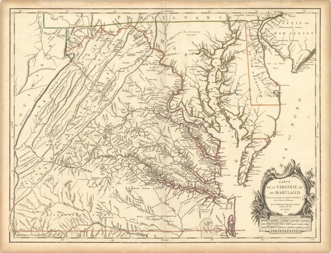
Auction 187, Lot 182
Subject: Colonial Mid-Atlantic United States
Robert de Vaugondy, Didier
Carte de la Virginie et du Maryland Dressee sur la Grande Carte Angloise de Mrs. Josue Fry et Pierre Jefferson, 1755
Size: 25.3 x 19.1 inches (64.3 x 48.5 cm)
Estimate: $2,200 - $2,500
First State of Robert de Vaugondy's Essential Map of Virginia and Maryland
Sold for: $2,300
Closed on 4/27/2022
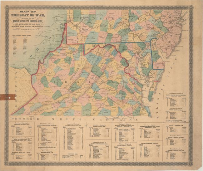
Auction 187, Lot 186
Subject: Mid-Atlantic United States, Civil War
Bridgens, H.F.
Map of the Seat of War, Exhibiting All the Important Positions of the Surrounding Country, and Approaches by Rail Road..., 1861
Size: 23 x 19.7 inches (58.4 x 50 cm)
Estimate: $300 - $400
Rare Civil War Map Listing the "Union Counties of West Virginia"
Sold for: $550
Closed on 4/27/2022
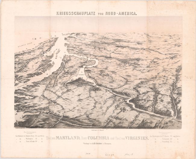
Auction 187, Lot 187
Subject: Mid-Atlantic United States, Civil War
Theil von Maryland, Distr. Columbia und Theil von Virginien, 1862
Size: 19.5 x 13.3 inches (49.5 x 33.8 cm)
Estimate: $1,200 - $1,500
Scarce Bird's-Eye View of Washington and Vicinity
Sold for: $900
Closed on 4/27/2022
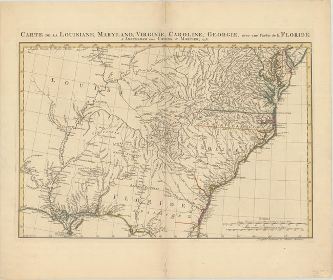
Auction 187, Lot 192
Subject: Colonial Southeast United States
Covens & Mortier
Carte de la Louisiane, Maryland, Virginie, Caroline, Georgie, avec une Partie de la Floride, 1758
Size: 23.1 x 15.4 inches (58.7 x 39.1 cm)
Estimate: $1,100 - $1,400
Covens & Mortier's Map of the Southeast Issued During the French and Indian War
Sold for: $750
Closed on 4/27/2022
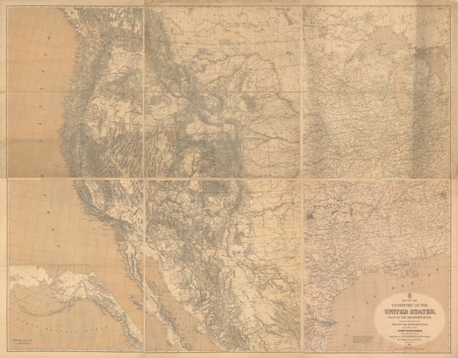
Auction 187, Lot 203
Subject: Western United States
U.S. Army
[On 6 Sheets] Map of the Territory of the United States, West of the Mississippi River. Prepared by Authority of the Hon. the Secretary of War..., 1879
Size: 26.5 x 31.3 inches (67.3 x 79.5 cm)
Estimate: $3,500 - $4,250
Freyhold's Updated & Enlarged Version of Warren's General Map
Sold for: $14,500
Closed on 4/27/2022
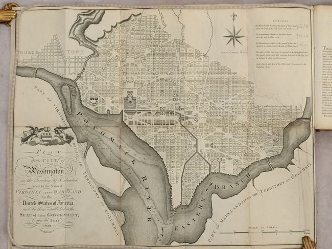
Auction 187, Lot 231
Subject: Washington, D.C.
Russell, John C.
Plan of the City of Washington in the Territory of Columbia... [bound in] An Historical Geographical, Commercial, and Philosophical View of the American United States, and of the European Settlements in America and the West-Indies... Vol. III, 1795
Size: 5.3 x 8.5 inches (13.5 x 21.6 cm)
Estimate: $2,300 - $2,750
Uncommon, Early Large-Format Map of Washington D.C.
Sold for: $1,200
Closed on 4/27/2022
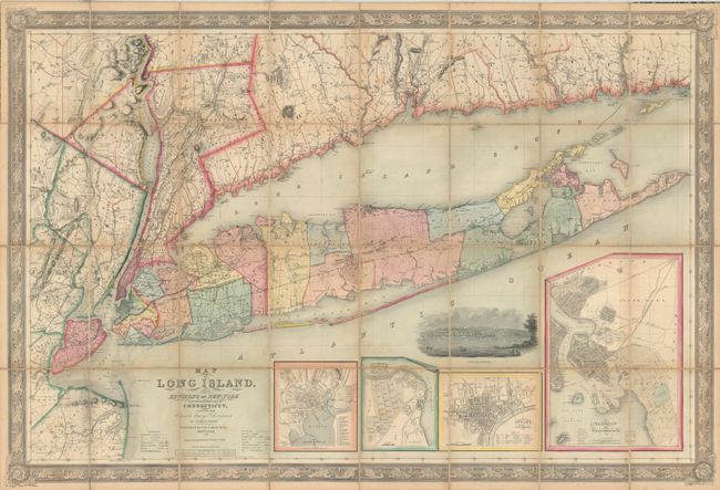
Auction 187, Lot 260
Subject: Long Island, New York
Smith, J. Calvin
Map of Long Island, with the Environs of New-York and the Southern Part of Connecticut, Compiled from Various Surveys & Documents, 1856
Size: 56.3 x 38 inches (143 x 96.5 cm)
Estimate: $2,400 - $3,000
Large-Scale Map of Long Island
Sold for: $2,300
Closed on 4/27/2022
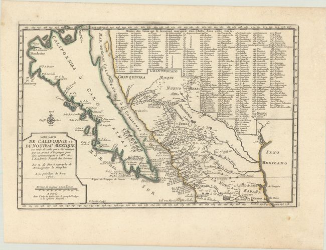
Auction 187, Lot 298
Subject: Southwestern United States & Mexico, California
Fer, Nicolas de
Cette Carte de Californie et du Nouveau Mexique, est Tiree de Celle qui a ete Envoyee par un Grand d'Espagne..., 1700
Size: 13.4 x 8.8 inches (34 x 22.4 cm)
Estimate: $1,200 - $1,500
De Fer's Important Map of the Island of California
Sold for: $900
Closed on 4/27/2022
19 lots