Showing Featured Lots(remove filter)
Filtered by Category:United States(Show All Categories)
Showing results for:Auction 183
Catalog Archive
11 lots
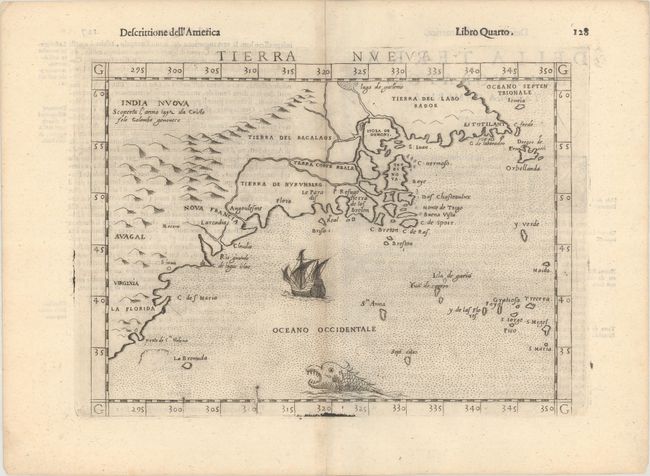
Auction 183, Lot 84
Subject: Eastern United States & Canada
Ruscelli, Girolamo
Tierra Nueva, 1598
Size: 9.6 x 7 inches (24.4 x 17.8 cm)
Estimate: $1,100 - $1,400
Ruscelli's Map of the East Coast
Sold for: $850
Closed on 6/9/2021
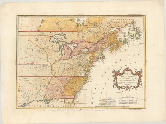
Auction 183, Lot 86
Subject: Colonial Eastern United States & Canada
Palairet, Jean
Carte des Possessions Angloises & Francoises du Continent de l'Amerique Septentrionale, 1756
Size: 22.8 x 16.3 inches (57.9 x 41.4 cm)
Estimate: $2,200 - $2,500
Important Map of French and English Territorial Claims at the Outset of the French & Indian War
Sold for: $2,000
Closed on 6/9/2021
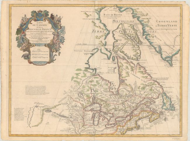
Auction 183, Lot 96
Subject: Colonial Northeastern United States & Canada, Great Lakes
Delisle, Guillaume
Carte du Canada ou de la Nouvelle France et des Decouvertes qui y ont ete Faites Dressee sur Plusieurs Observations et sur un Grand Nombre de Relations Imprimees ou Manuscrites..., 1703
Size: 25.6 x 19.6 inches (65 x 49.8 cm)
Estimate: $1,600 - $1,900
Delisle's Seminal Map of Canada and the Great Lakes
Sold for: $1,400
Closed on 6/9/2021
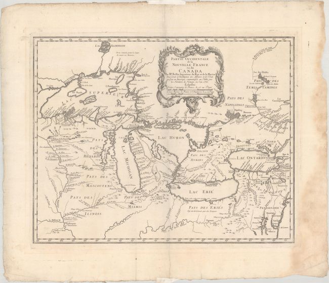
Auction 183, Lot 99
Subject: Colonial Great Lakes
Bellin/Homann Heirs
Partie Occidentale de la Nouvelle France ou du Canada, 1755
Size: 21.4 x 16.8 inches (54.4 x 42.7 cm)
Estimate: $1,400 - $1,700
Influential Map of the Great Lakes
Sold for: $1,200
Closed on 6/9/2021
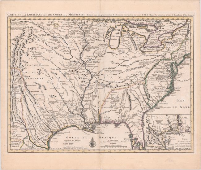
Auction 183, Lot 117
Subject: Colonial Eastern United States, Louisiana Territory
Delisle/Covens & Mortier
Carte de la Louisiane et du Cours du Mississipi Dressee sur un Grand Nombre de Memoires Entr' Autres sur ceux de Mr. le Maire, 1730
Size: 23.6 x 17.3 inches (59.9 x 43.9 cm)
Estimate: $1,900 - $2,200
Delisle's Influential Map of the Louisiana Territory
Sold for: $2,000
Closed on 6/9/2021
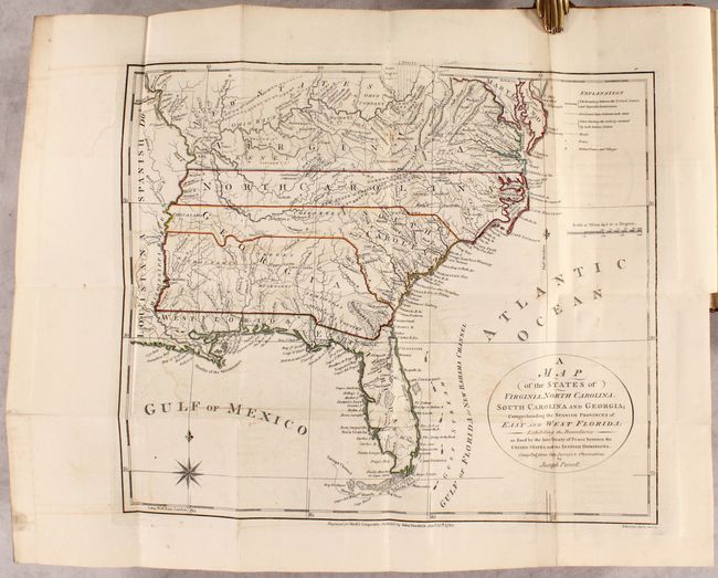
Auction 183, Lot 118
Subject: Eastern United States, Franklin
Morse, Jedidiah (Rev.)
[2 Maps in Book] A Map of the States of Virginia, North Carolina, South Carolina and Georgia; Comprehending the Spanish Provinces of East and West Florida... [and] A Map of the Northern and Middle States... [bound in] The American Geography..., 1792
Size: 14.4 x 12.4 inches (36.6 x 31.5 cm)
Estimate: $1,200 - $1,500
Includes Purcell's Map Locating the Proposed State of Franklin
Sold for: $1,600
Closed on 6/9/2021
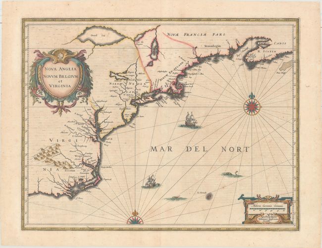
Auction 183, Lot 130
Subject: Colonial New England & Mid-Atlantic United States
Jansson, Jan
Nova Anglia Novum Belgium et Virginia, 1639
Size: 19.9 x 15.3 inches (50.5 x 38.9 cm)
Estimate: $1,400 - $1,700
Jansson's Influential Map of the East Coast
Unsold
Closed on 6/9/2021
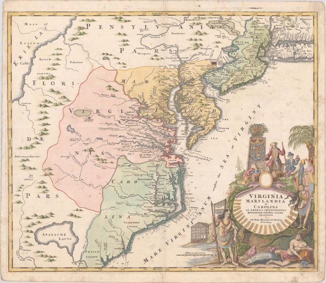
Auction 183, Lot 135
Subject: Colonial Mid-Atlantic United States
Homann, Johann Baptist
Virginia Marylandia et Carolina in America Septentrionali Britannorum Industria Excultae Repraesentatae, 1730
Size: 22.8 x 19.1 inches (57.9 x 48.5 cm)
Estimate: $1,500 - $1,800
Map Created to Promote German Immigration to the New World
Sold for: $1,000
Closed on 6/9/2021
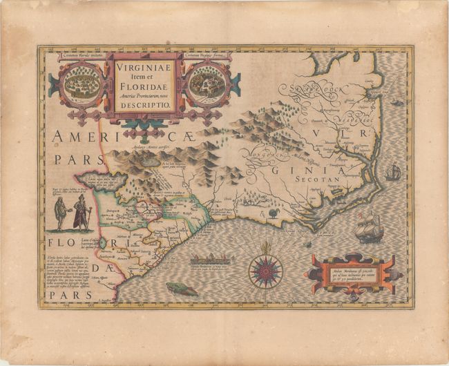
Auction 183, Lot 139
Subject: Colonial Southeast United States
Hondius, Jodocus
Virginiae Item et Floridae Americae Provinciarum, Nova Descriptio, 1619
Size: 19.3 x 13.6 inches (49 x 34.5 cm)
Estimate: $1,800 - $2,100
A Seminal Map of the Southeast and Early American Cartography - Full Contemporary Color
Sold for: $1,300
Closed on 6/9/2021
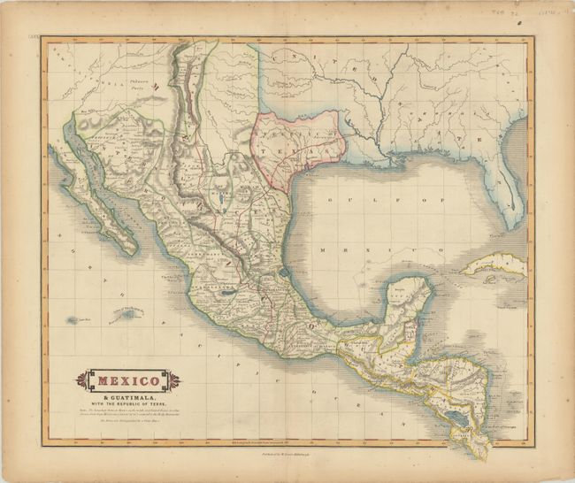
Auction 183, Lot 248
Subject: Southern United States, Mexico & Central America, Texas
Lizars, William Home
Mexico & Guatimala, with the Republic of Texas, 1838
Size: 19.2 x 16.6 inches (48.8 x 42.2 cm)
Estimate: $1,100 - $1,400
One of the Few Maps to Include "Republic" in the Title
Sold for: $850
Closed on 6/9/2021
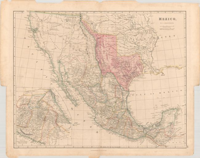
Auction 183, Lot 253
Subject: Southwestern United States & Mexico, Texas
Arrowsmith, John
Mexico, 1842
Size: 23.6 x 18.9 inches (59.9 x 48 cm)
Estimate: $1,600 - $1,900
Features the Republic of Texas in its Largest Configuration
Sold for: $1,200
Closed on 6/9/2021
11 lots