Showing Featured Lots(remove filter)
Filtered by Category:United States(Show All Categories)
Showing results for:Auction 171
Catalog Archive
24 lots
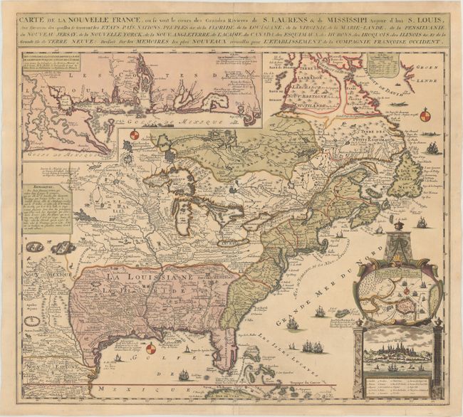
Auction 171, Lot 123
Subject: Colonial Eastern United States & Canada
Fer, Nicolas de
Carte de la Nouvelle France, ou se voit le Cours des Grandes Rivieres de S. Laurens & de Mississipi Aujour d'hui S. Louis, aux Environs des-quelles se Trouvent les Etats, Pais, Nations, Peuples &c..., 1719
Size: 21.4 x 19.5 inches (54.4 x 49.5 cm)
Estimate: $2,300 - $2,750
Striking Map of French Colonial Possessions
Sold for: $1,700
Closed on 2/6/2019
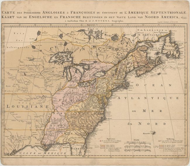
Auction 171, Lot 124
Subject: Colonial Eastern United States & Canada
Ottens, Reiner and Joshua
Carte des Possessions Angloises & Francoises du Continent de l'Amerique Septentrionale / Kaart van de Engelsche en Fransche Bezittingen in het Vaste Land van Noord America, 1755
Size: 22.4 x 16.3 inches (56.9 x 41.4 cm)
Estimate: $2,000 - $2,300
Dutch Version of an Important Map Showing Territorial Claims at the Outset of the French and Indian War
Unsold
Closed on 2/6/2019
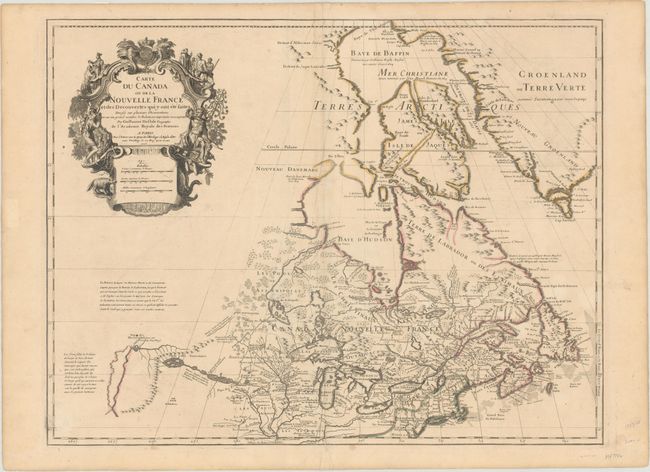
Auction 171, Lot 130
Subject: Colonial Northeastern United States & Canada, Great Lakes
Delisle, Guillaume
Carte du Canada ou de la Nouvelle France et des Decouvertes qui y ont ete Faites Dressee sur Plusieurs Observations..., 1703
Size: 25.6 x 19.6 inches (65 x 49.8 cm)
Estimate: $2,200 - $2,500
Delisle's Seminal Map of Canada and the Great Lakes
Sold for: $1,200
Closed on 2/6/2019
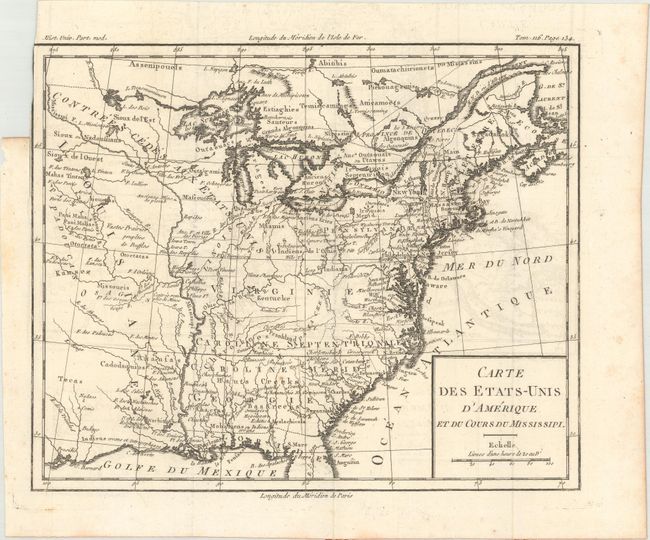
Auction 171, Lot 150
Subject: Eastern United States, Franklin
Brion de la Tour, Louis
Carte des Etats-Unis d'Amerique et du Cours du Mississipi, 1788
Size: 10.6 x 8.7 inches (26.9 x 22.1 cm)
Estimate: $900 - $1,100
One of the Earliest Maps to Feature the State of Franklin
Unsold
Closed on 2/6/2019
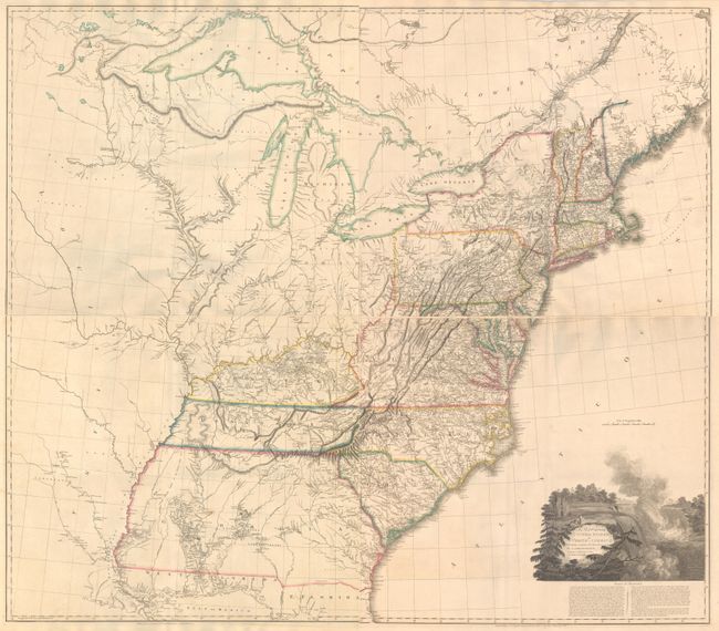
Auction 171, Lot 156
Subject: Eastern United States
Arrowsmith, Aaron, Sr.
[On 4 Sheets] A Map of the United States of North America Drawn from a Number of Critical Researches, 1815
Size: 27.8 x 24.3 inches (70.6 x 61.7 cm)
Estimate: $9,000 - $11,000
Large Format Map Used by Lewis & Clark
Unsold
Closed on 2/6/2019
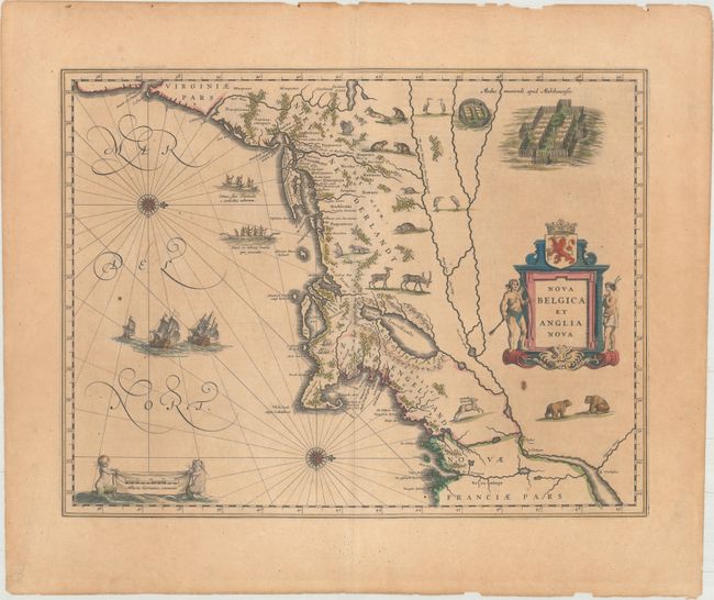
Auction 171, Lot 163
Subject: Colonial New England & Mid-Atlantic United States
Blaeu, Willem
Nova Belgica et Anglia Nova, 1643
Size: 19.8 x 15.1 inches (50.3 x 38.4 cm)
Estimate: $2,200 - $2,500
Important Map of Colonial New England and the Mid-Atlantic
Unsold
Closed on 2/6/2019
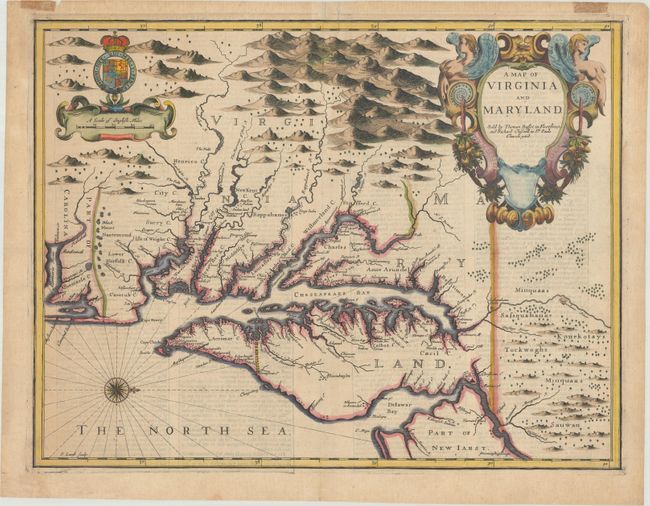
Auction 171, Lot 166
Subject: Colonial Mid-Atlantic United States
Speed/Lamb
A Map of Virginia and Maryland, 1676
Size: 19.4 x 14.9 inches (49.3 x 37.8 cm)
Estimate: $4,750 - $6,000
The First Printed Map to Draw Upon the Legendary Herrman Map of the Chesapeake Bay - Previously Owned by Coolie Verner
Unsold
Closed on 2/6/2019
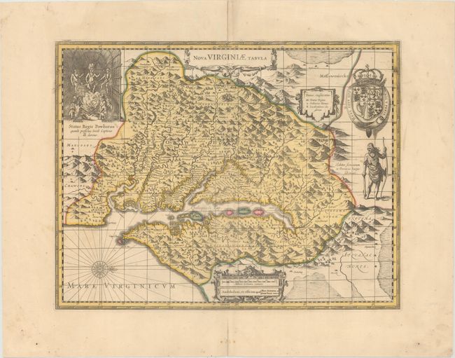
Auction 171, Lot 168
Subject: Colonial Mid-Atlantic United States
Hondius/Schenk & Valck
Nova Virginiae Tabula, 1700
Size: 19.2 x 14.8 inches (48.8 x 37.6 cm)
Estimate: $1,400 - $1,800
One of the Most Important 17th Century Maps of the Chesapeake Bay
Unsold
Closed on 2/6/2019
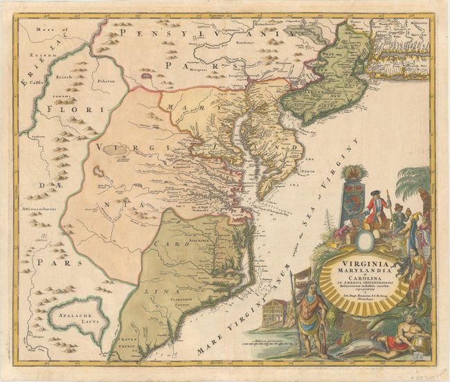
Auction 171, Lot 169
Subject: Colonial Mid-Atlantic United States
Homann, Johann Baptist
Virginia Marylandia et Carolina in America Septentrionali Britannorum Industria Excultae, 1730
Size: 22.8 x 19.2 inches (57.9 x 48.8 cm)
Estimate: $1,900 - $2,200
Map Created to Promote German Immigration to the New World
Unsold
Closed on 2/6/2019
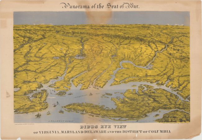
Auction 171, Lot 177
Subject: Mid-Atlantic United States, Civil War
Bachmann, John
Panorama of the Seat of War. Birds Eye View of Virginia, Maryland Delaware and the District of Columbia, 1864
Size: 28.3 x 17.9 inches (71.9 x 45.5 cm)
Estimate: $1,800 - $2,200
Bachmann's "Aerial" View of the Mid-Atlantic
Sold for: $900
Closed on 2/6/2019
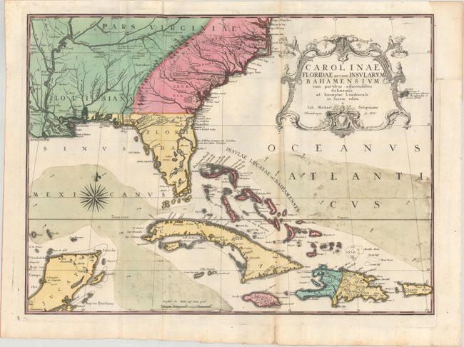
Auction 171, Lot 178
Subject: Colonial Southeast United States, Bahamas & Greater Antilles
Seligmann, Johann Michael
Carolinae Floridae nec non Insularum Bahamensium cum Partibus Adjacendibus Delineatio ad Exemplar Londinense in Lucem Edita, 1755
Size: 23 x 16.8 inches (58.4 x 42.7 cm)
Estimate: $3,750 - $4,500
German Edition of Catesby's Scarce and Important Map of the Southeastern United States
Unsold
Closed on 2/6/2019
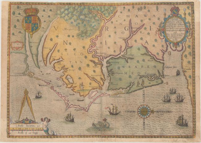
Auction 171, Lot 179
Subject: Colonial Southeast United States
White/De Bry
Americae Pars, nunc Virginia Dicta, Primum ab Anglis Inventa, Sumtibus Dn. Walteri Raleigh..., 1590
Size: 16.4 x 11.9 inches (41.7 x 30.2 cm)
Estimate: $11,000 - $13,000
The Earliest Collectible Map of Eastern North Carolina & Virginia
Sold for: $11,500
Closed on 2/6/2019
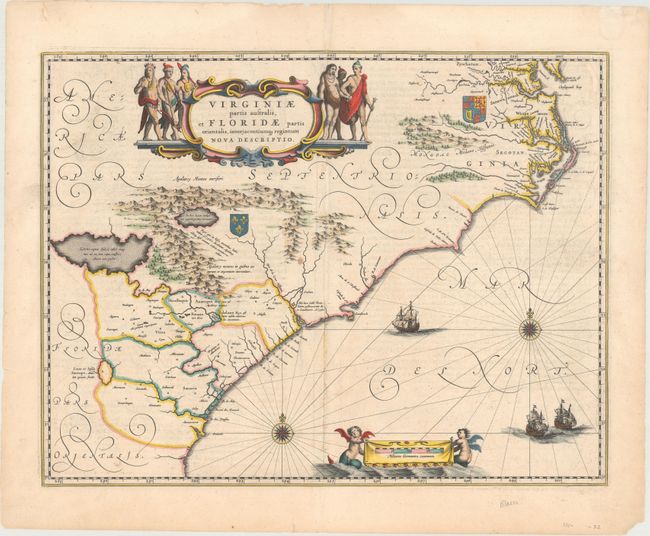
Auction 171, Lot 181
Subject: Colonial Southeast United States
Blaeu, Willem
Virginiae Partis Australis, et Floridae Partis Orientalis, Interjacentiumq Regionum Nova Descriptio, 1640
Size: 19.9 x 15.1 inches (50.5 x 38.4 cm)
Estimate: $1,100 - $1,400
Blaeu's Decorative Map of the Southeast
Sold for: $800
Closed on 2/6/2019
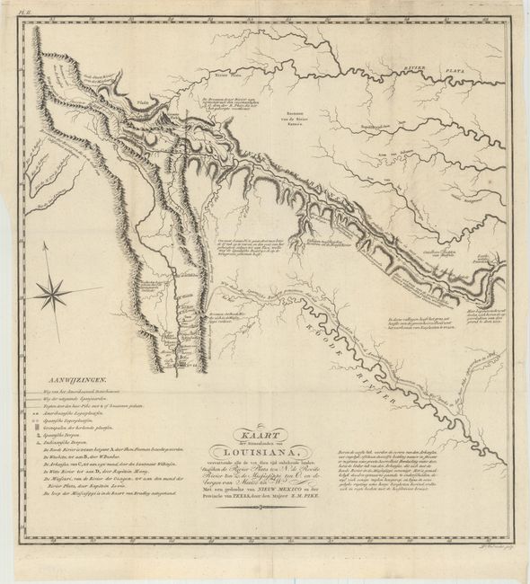
Auction 171, Lot 208
Subject: Southwestern United States
Pike, Zebulon
Kaart der Binnenlanden van Louisiana, Vervattende alle de tot dien tijd Onbekende Landen..., 1812
Size: 14.7 x 15.6 inches (37.3 x 39.6 cm)
Estimate: $2,200 - $2,500
A Cornerstone Map of Early Western Exploration
Unsold
Closed on 2/6/2019
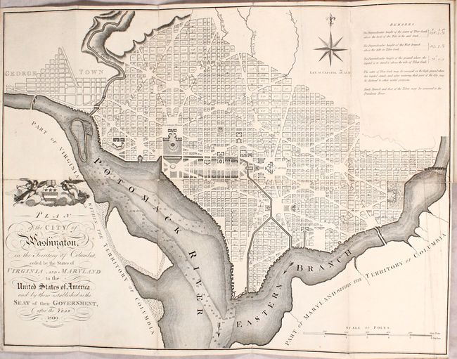
Auction 171, Lot 232
Subject: Washington, D.C.
Russell, John C.
Plan of the City of Washington in the Territory of Columbia... [bound in] An Historical Geographical, Commercial, and Philosophical View of the American United States, and of the European Settlements in America and the West-Indies... Vol. III, 1795
Size: 5.3 x 8.5 inches (13.5 x 21.6 cm)
Estimate: $2,400 - $3,000
Uncommon, Early Large-Format Map of Washington D.C.
Unsold
Closed on 2/6/2019
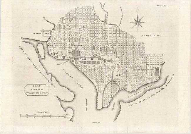
Auction 171, Lot 233
Subject: Washington, D.C.
Plan of the City of Washington, 1805
Size: 10.6 x 8.3 inches (26.9 x 21.1 cm)
Estimate: $1,400 - $1,700
Rare Second Scottish Plan of DC
Unsold
Closed on 2/6/2019
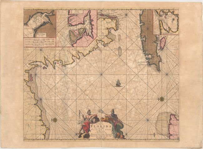
Auction 171, Lot 237
Subject: Florida & Cuba
Keulen, Johannes van
Pas Kaart van de Boght van Florida met de Canaal Tusschen Florida en Cuba, 1700
Size: 23.2 x 19.9 inches (58.9 x 50.5 cm)
Estimate: $3,000 - $3,750
One of the First Charts of the Florida Gulf Coast in Full Contemporary Color
Unsold
Closed on 2/6/2019
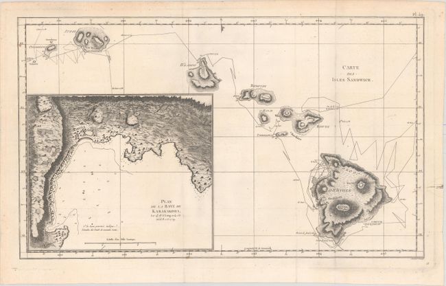
Auction 171, Lot 246
Subject: Hawaii
Cook/Benard
Carte des Isles Sandwich, 1785
Size: 18 x 10.8 inches (45.7 x 27.4 cm)
Estimate: $800 - $1,000
Important Map of the Hawaiian Islands
Sold for: $425
Closed on 2/6/2019
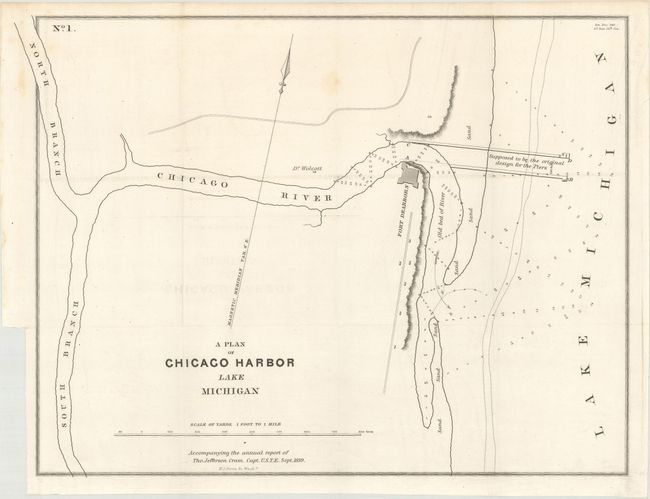
Auction 171, Lot 258
Subject: Chicago, Illinois, Lake Michigan
Cram, Thomas Jefferson (Capt.)
A Plan of Chicago Harbor Lake Michigan, 1839
Size: 14.9 x 11.2 inches (37.8 x 28.4 cm)
Estimate: $700 - $850
Early Map of Chicago
Sold for: $250
Closed on 2/6/2019
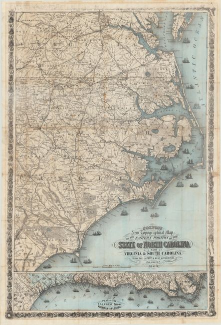
Auction 171, Lot 276
Subject: North Carolina, Civil War
Colton, Joseph Hutchins
Colton's New Topographical Map of the Eastern Portion of the State of North Carolina with Part of Virginia & South Carolina from the Latest and Best Authorities, 1864
Size: 27 x 39.9 inches (68.6 x 101.3 cm)
Estimate: $2,000 - $2,400
Rare Civil War Map of Eastern North Carolina
Sold for: $1,600
Closed on 2/6/2019
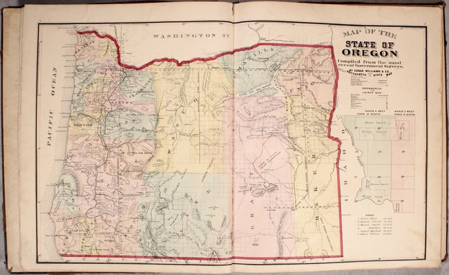
Auction 171, Lot 281
Subject: Oregon
Historical Atlas Map of Marion & Linn Counties Oregon..., 1878
Size: 14.5 x 17.6 inches (36.8 x 44.7 cm)
Estimate: $2,000 - $2,500
The First County Atlas for Oregon
Unsold
Closed on 2/6/2019
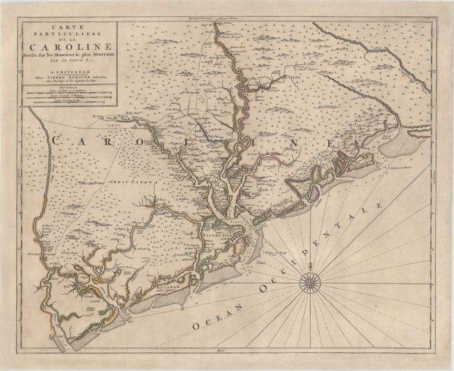
Auction 171, Lot 284
Subject: Colonial South Carolina, Charleston
Sanson/Mortier
Carte Particuliere de la Caroline Dressee sur les Memoires le Plus Nouveaux, 1700
Size: 23.4 x 18.9 inches (59.4 x 48 cm)
Estimate: $3,750 - $4,500
Foundation Map of South Carolina - First State
Unsold
Closed on 2/6/2019
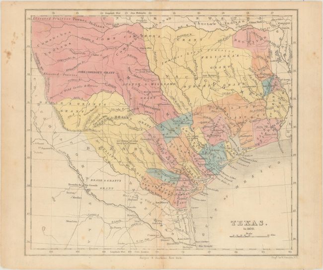
Auction 171, Lot 287
Subject: Republic of Texas
Kemble, W.
Texas. In 1836, 1846
Size: 9.3 x 8.3 inches (23.6 x 21.1 cm)
Estimate: $1,200 - $1,500
Republic of Texas with Land Grants
Sold for: $900
Closed on 2/6/2019
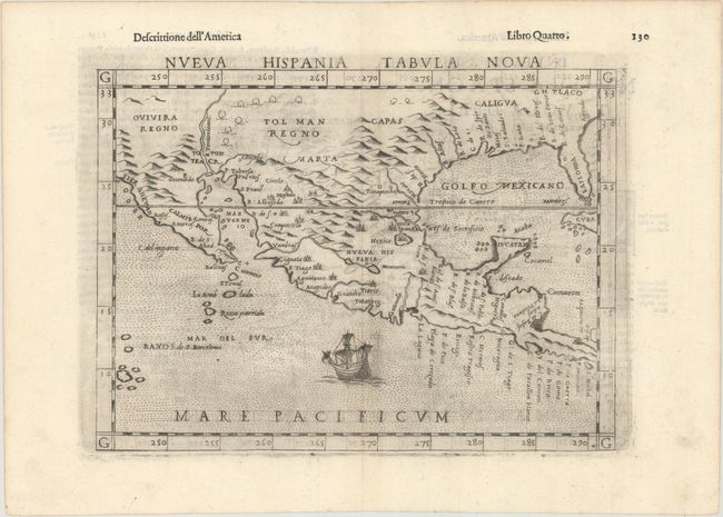
Auction 171, Lot 309
Subject: Southern United States & Mexico
Ruscelli, Girolamo
Nueva Hispania Tabula Nova, 1598
Size: 9.6 x 7.1 inches (24.4 x 18 cm)
Estimate: $1,200 - $1,500
A Foundation Map for the American Southwest
Sold for: $750
Closed on 2/6/2019
24 lots