Showing Featured Lots(remove filter)
Filtered by Category:United States(Show All Categories)
Showing results for:Auction 136
Catalog Archive
20 lots
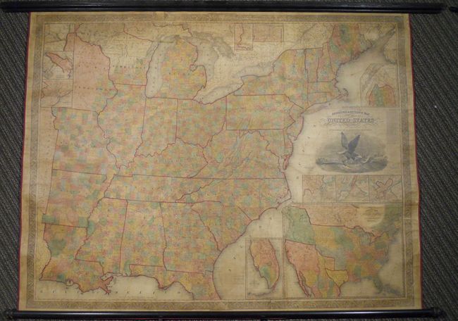
Auction 136, Lot 149
Subject: United States, Republic of Texas
Mitchell, Samuel Augustus
Mitchell's Reference & Distance Map of the United States, 1844
Size: 67 x 52.5 inches (170.2 x 133.4 cm)
Estimate: $8,000 - $10,000
Exceptional Wall Map Featuring the Independent Republic of Texas - 1844
Unsold
Closed on 6/1/2011
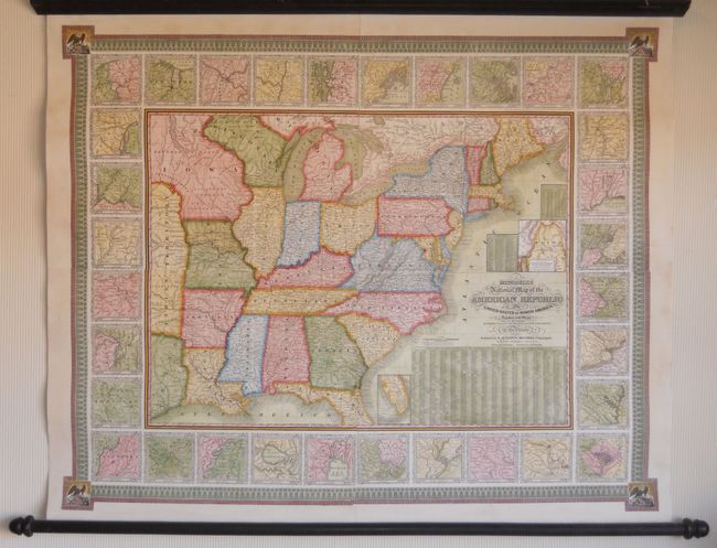
Auction 136, Lot 152
Subject: United States
Ensign, Thayer & Co.
Ensign's Travellers' Guide, and Map of the United States, Containing the Roads, Distances, Steam Boat and Canal Routes &c., 1848
Size: 39 x 26 inches (99.1 x 66 cm)
Estimate: $2,500 - $3,000
Flawless example of Ensign & Thayer's rare wall map
Sold for: $1,800
Closed on 6/1/2011
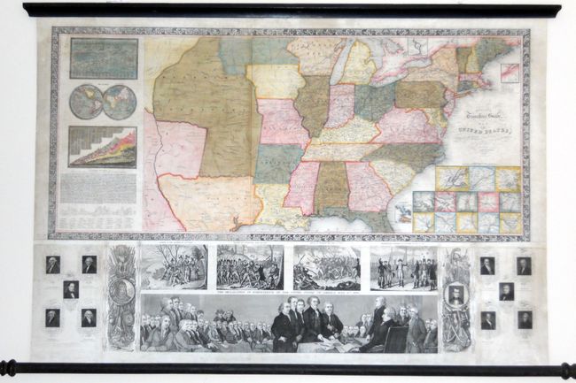
Auction 136, Lot 176
Subject: Eastern United States
Mitchell, Samuel Augustus
Mitchell's National Map of the American Republic or United States of North America, Together with Maps of the Vicinities of Thirty-Two of the Principal Cities and Towns in the Union, 1843
Size: 47 x 38 inches (119.4 x 96.5 cm)
Estimate: $2,500 - $3,000
Remarkable Example of Mitchell's Wall Map
Unsold
Closed on 6/1/2011
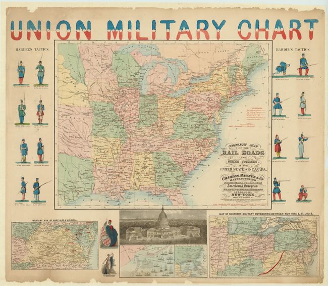
Auction 136, Lot 180
Subject: Eastern United States
Magnus & Co.
Union Military Chart, 1861-62
Size: 28 x 24 inches (71.1 x 61 cm)
Estimate: $800 - $1,200
Colorful Civil War Railroad Map
Sold for: $1,400
Closed on 6/1/2011
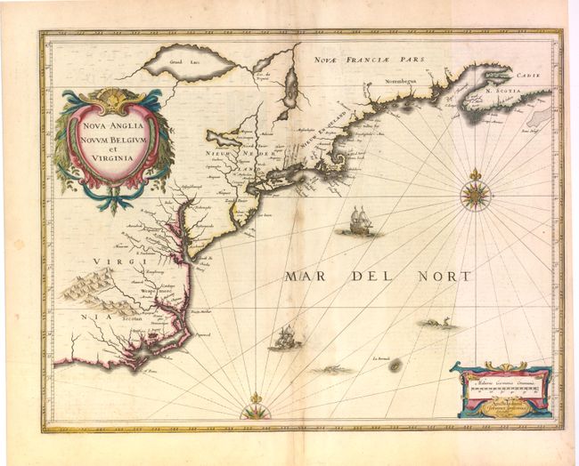
Auction 136, Lot 190
Subject: Colonial New England and Mid-Atlantic
Jansson, Jan
Nova Anglia Novum Belgium et Virginia, 1636
Size: 20 x 15.3 inches (50.8 x 38.9 cm)
Estimate: $1,900 - $2,200
Jansson's influential map of the East Coast
Unsold
Closed on 6/1/2011
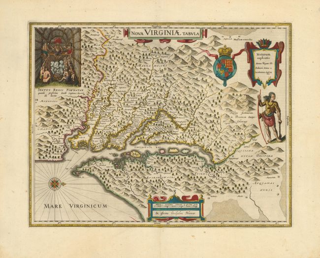
Auction 136, Lot 195
Subject: Colonial Mid-Atlantic
Hondius/Blaeu
Nova Virginiae Tabula, 1642
Size: 19 x 15 inches (48.3 x 38.1 cm)
Estimate: $2,750 - $3,500
One of the most important 17th century maps of the Chesapeake Bay
Sold for: $2,100
Closed on 6/1/2011
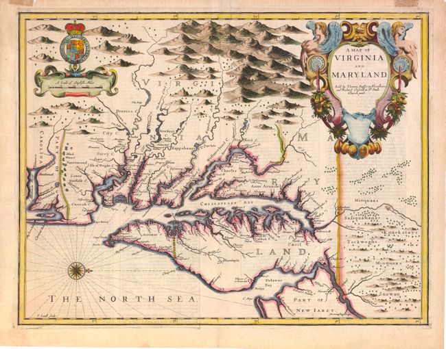
Auction 136, Lot 196
Subject: Colonial Mid-Atlantic
Speed/Lamb
A Map of Virginia and Maryland, 1676
Size: 19.5 x 15 inches (49.5 x 38.1 cm)
Estimate: $4,750 - $5,500
The first printed map to draw upon the legendary Herrman map of the Chesapeake Bay
Sold for: $3,500
Closed on 6/1/2011
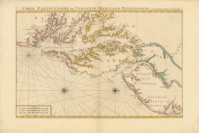
Auction 136, Lot 198
Subject: Colonial Mid-Atlantic
Jaillot/Mortier
Carte Particuliere de Virginie, Maryland, Pennsilvanie, la Nouvelle Iarsey Orient et Occidental, 1700
Size: 31.5 x 20.5 inches (80 x 52.1 cm)
Estimate: $7,000 - $9,000
One of the Most Beautiful Charts of Maryland and the Chesapeake Bay
Unsold
Closed on 6/1/2011
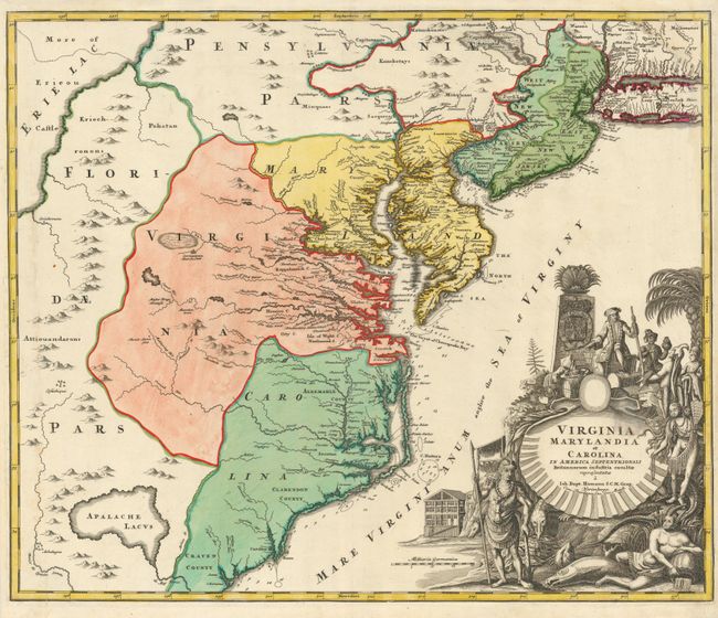
Auction 136, Lot 200
Subject: Colonial Mid-Atlantic
Homann, Johann Baptist
Virginia Marylandia et Carolina in America Septentrionali Britannorum industria excultae, 1730
Size: 22.8 x 19.2 inches (57.9 x 48.8 cm)
Estimate: $1,900 - $2,200
Sold for: $1,200
Closed on 6/1/2011
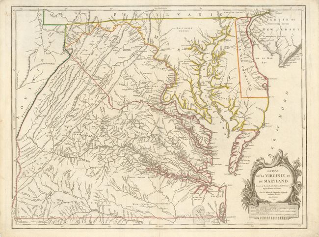
Auction 136, Lot 201
Subject: Colonial Mid-Atlantic
Robert de Vaugondy, Didier
Carte de la Virginie et du Maryland Dressee sur la Grande Carte Angloise de Mrs. Josue Fry et Pierre Jefferson…, 1755
Size: 25.5 x 19.2 inches (64.8 x 48.8 cm)
Estimate: $3,000 - $3,750
An Essential Map of Virginia and Maryland
Sold for: $2,300
Closed on 6/1/2011
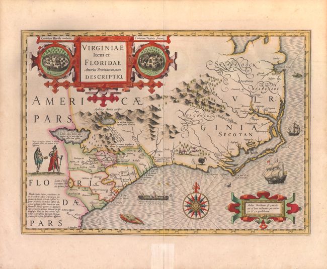
Auction 136, Lot 211
Subject: Colonial Southeast
Hondius, Jodocus
Virginiae Item et Floridae Americae Provinciarum, Nova Descriptio, 1619
Size: 19 x 13.5 inches (48.3 x 34.3 cm)
Estimate: $2,750 - $3,500
A Seminal Map of the Southeast and early American cartography
Sold for: $2,000
Closed on 6/1/2011
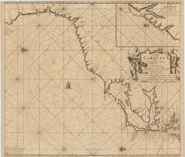
Auction 136, Lot 214
Subject: Colonial Southeast
Keulen, Johannes van
Pas Kaart Van de Kust van Carolina Tusschen C de Canaveral en C Henry…, 1687
Size: 22 x 20 inches (55.9 x 50.8 cm)
Estimate: $3,500 - $4,500
Scarce Dutch chart of the Carolinas
Sold for: $2,500
Closed on 6/1/2011
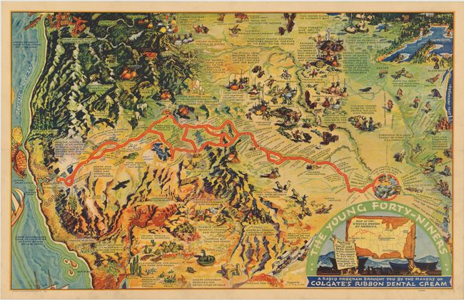
Auction 136, Lot 246
Subject: Western United States
The Young Forty-Niners, 1933
Size: 30 x 18.8 inches (76.2 x 47.8 cm)
Estimate: $180 - $240
Cartograph-style California Gold Rush map
Sold for: $375
Closed on 6/1/2011
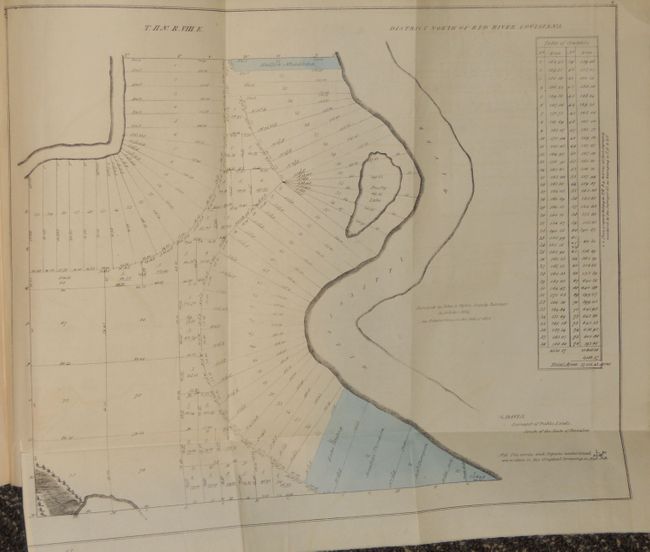
Auction 136, Lot 298
Subject: Louisiana
Third Report from the Select Committee on Emigration from the United Kingdom, 1827
Size: 8.5 x 13.2 inches (21.6 x 33.5 cm)
Estimate: $1,600 - $2,400
Rare Parliamentary Report Regarding Emigration from Britain to the United States
Unsold
Closed on 6/1/2011
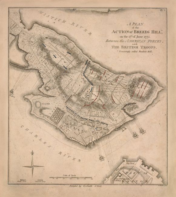
Auction 136, Lot 304
Subject: Boston, Massachusetts
Smith, Charles
A Plan of the Action at Breeds Hill*, on the 17th of June 1775. Between the American Forces, and the British Troops. *Erroneously Called Bunkers Hill, 1796
Size: 8.3 x 9.2 inches (21.1 x 23.4 cm)
Estimate: $3,000 - $4,000
The first detailed plan of the Battle of Bunker Hill published in the United States
Unsold
Closed on 6/1/2011
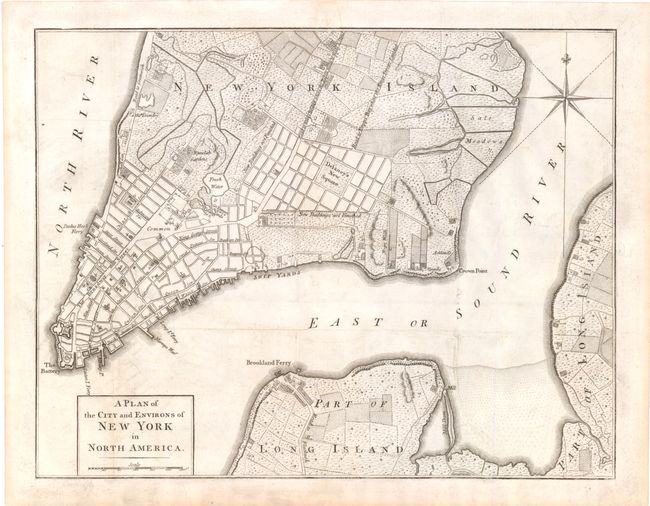
Auction 136, Lot 322
Subject: New York City, New York
Anon.
A Plan of the City and Environs of New York in North America, 1776
Size: 14.5 x 11.3 inches (36.8 x 28.7 cm)
Estimate: $1,500 - $1,800
Sold for: $1,900
Closed on 6/1/2011
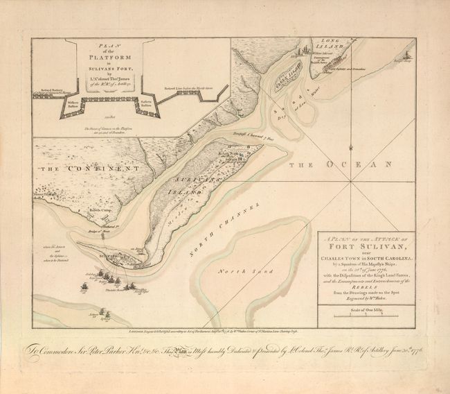
Auction 136, Lot 336
Subject: Charleston, South Carolina
Faden, William
A Plan of the Attack of Fort Sulivan, near Charles Town in South Carolina…, 1776
Size: 14.6 x 11 inches (37.1 x 27.9 cm)
Estimate: $10,000 - $12,000
Important Revolutionary War Map
Unsold
Closed on 6/1/2011
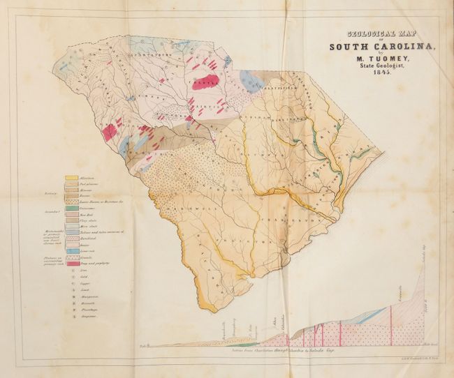
Auction 136, Lot 339
Subject: South Carolina
Tuomey, Michael
Geological Map of South Carolina, by M. Tuomey, State Geologist, 1845, 1848
Size: 9 x 10.5 inches (22.9 x 26.7 cm)
Estimate: $400 - $500
Early Geological Map of South Carolina
Unsold
Closed on 6/1/2011
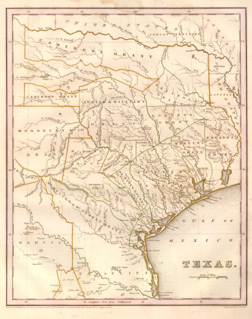
Auction 136, Lot 340
Subject: Republic of Texas
Bradford, Thomas Gamaliel
Texas, 1838
Size: 11.3 x 14.4 inches (28.7 x 36.6 cm)
Estimate: $2,500 - $3,000
Bradford's Republic of Texas
Sold for: $2,100
Closed on 6/1/2011
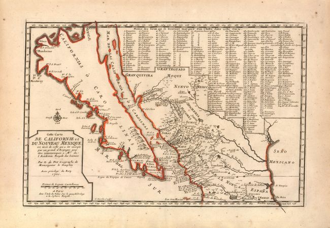
Auction 136, Lot 361
Subject: California, Southwest and Mexico
Fer, Nicolas de
Cette Carte de Californie et du Nouveau Mexique…, 1700
Size: 13.3 x 8.8 inches (33.8 x 22.4 cm)
Estimate: $1,400 - $1,900
Sold for: $1,100
Closed on 6/1/2011
20 lots