Subject: Eastern United States
Period: 1861-62 (circa)
Publication:
Color: Printed Color
Size:
28 x 24 inches
71.1 x 61 cm
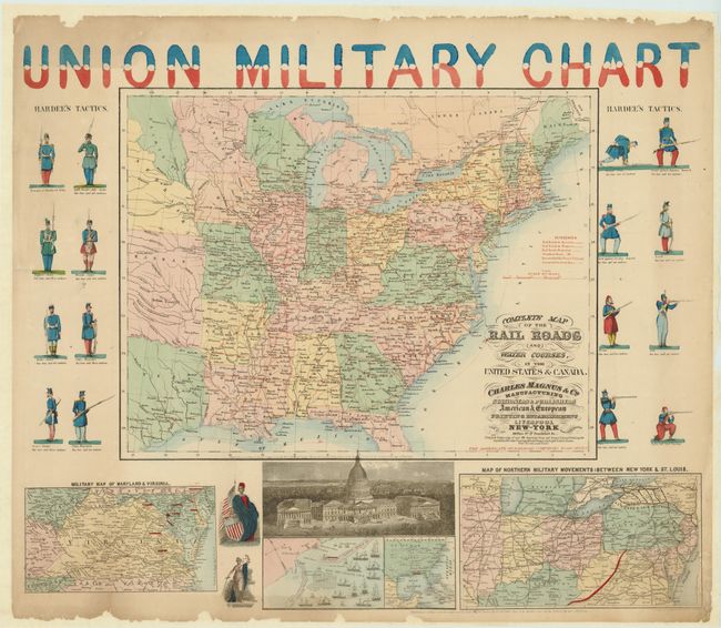
This unique and rare Civil War map has the title printed in bold red & blue above the map. The piece is a composition containing at center the "Complete Map of the Rail Roads and Water Courses, in the United States & Canada" (19" x 14.8"), with vignettes at sides depicting 16 soldiers demonstrating the various positions of Hardee's Tactics. The lower panel is filled with four inset maps: Map of Northern Military Movements: Between New York & St. Louis; chart of the naval base and Fort Pickens at Pensacola with ships and defenses indicated; Military Map of Maryland & Virginia; and a general map of the United States to include the Gulf of Mexico. Also with female allegorical figures representing Justice and Liberty, and a large engraved bird's-eye view of the Capital Building in Washington. The main map uses red overprinting to highlight Railroads, Railroad in Progress, Proposed Railroads, Steamboat Routes, and Telegraph lines. Published by Charles Magnus & Co. "Manufacturing Stationers & Publishers American & European Printing Establishment Liverpool New-York" with advertising text below cartouche. This decorative edition varies slightly from the references given as they do not have the soldiers at the sides.
References: cf Stephenson 14.33, cf Modelski 44.
Condition: B+
A little toning at upper margin and some marginal chipping at top and bottom edge. The map has recently been professionally backed with thick Japanese tissue to stabilize the thin paper.