Showing Featured Lots(remove filter)
Filtered by Category:Europe & Mediterranean(Show All Categories)
Showing results for:Auction 170
Catalog Archive
12 lots
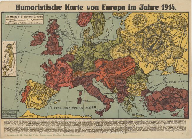
Auction 170, Lot 444
Subject: Europe, World War I
Leutert & Schneiderwind
Humoristische Karte von Europa im Jahre 1914, 1914
Size: 19.1 x 10.9 inches (48.5 x 27.7 cm)
Estimate: $1,300 - $1,700
Rare Satirical Map of Europe at Start of World War I
Unsold
Closed on 11/14/2018
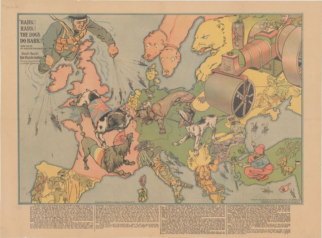
Auction 170, Lot 445
Subject: Europe, World War I
Bacon, G. W. & Company
Hark! Hark! The Dogs Do Bark! / Horch! Horch! Die Hunde Bellen!, 1914
Size: 25.4 x 17 inches (64.5 x 43.2 cm)
Estimate: $1,800 - $2,400
Rare German Edition of Political Caricature Map of Europe Featuring Dogs
Sold for: $1,000
Closed on 11/14/2018
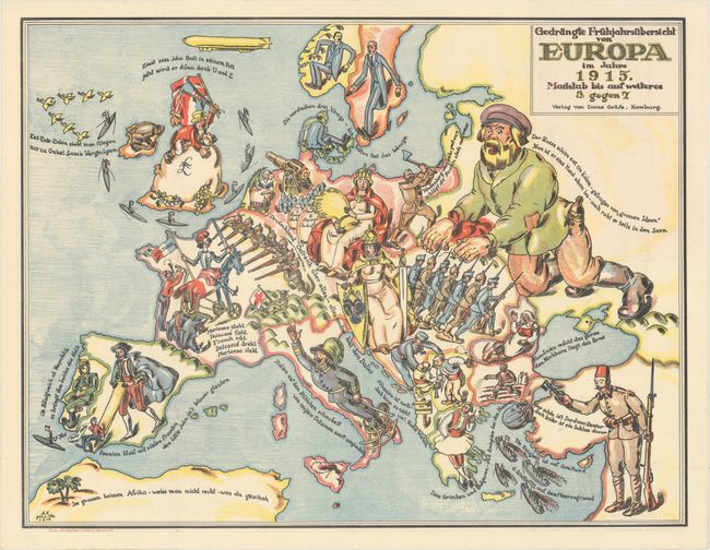
Auction 170, Lot 446
Subject: Europe, World War I
Gedrangte Fruhjahrsubersicht von Europa im Jahre 1915, 1915
Size: 26.3 x 20.2 inches (66.8 x 51.3 cm)
Estimate: $1,800 - $2,200
Rare German Satirical Map of World War I
Sold for: $1,000
Closed on 11/14/2018
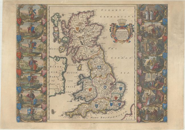
Auction 170, Lot 448
Subject: Britain
Blaeu, Johannes
Britannia Prout Divisa suit Temporibus Anglo-Saxonum, Praesertim Durante Illorum Heptarchia, 1658
Size: 20.7 x 16.3 inches (52.6 x 41.4 cm)
Estimate: $2,200 - $2,500
Decorative Map of Britain with Vignettes of Saxon History - Spanish Edition
Sold for: $875
Closed on 11/14/2018
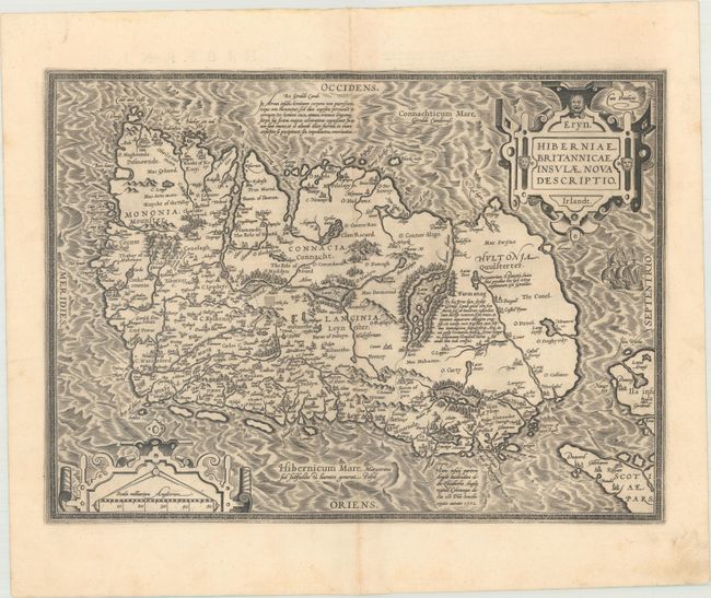
Auction 170, Lot 472
Subject: Ireland
Ortelius, Abraham
Eryn. Hiberniae, Britannicae Insulae, Nova Descriptio. Irlandt, 1595
Size: 19 x 13.9 inches (48.3 x 35.3 cm)
Estimate: $1,500 - $1,800
Ortelius' First Map of Ireland
Unsold
Closed on 11/14/2018
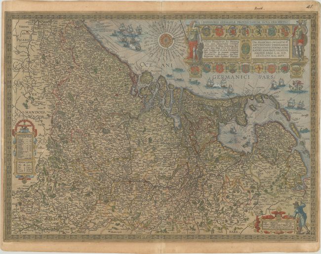
Auction 170, Lot 491
Subject: Low Countries
Ortelius, Abraham
Inferioris Germaniae Provinciarum Nova Descriptio, 1609
Size: 22.1 x 16.3 inches (56.1 x 41.4 cm)
Estimate: $1,200 - $1,500
Rare Decorative Map of the Low Countries in Contemporary Color
Unsold
Closed on 11/14/2018
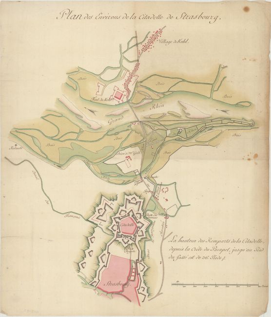
Auction 170, Lot 503
Subject: Strasbourg, France
Anon.
Plan des Environs de la Citadelle de Strasbourg, 1770
Size: 13.3 x 14.8 inches (33.8 x 37.6 cm)
Estimate: $1,300 - $1,600
Stunning Manuscript Map Showing the Fortifications of Strasbourg
Unsold
Closed on 11/14/2018
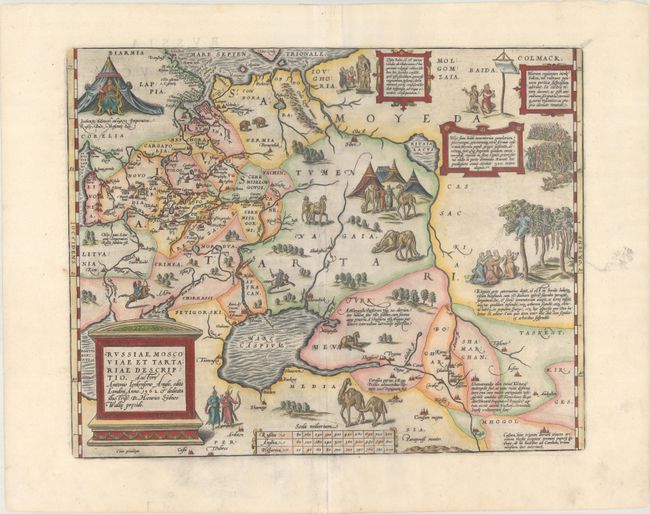
Auction 170, Lot 540
Subject: Russia, Eastern Europe & Central Asia
Ortelius, Abraham
Russiae, Moscoviae et Tartatiae Descriptio. Auctore Antonio Ienkensono Anglo..., 1603
Size: 17.5 x 13.8 inches (44.5 x 35.1 cm)
Estimate: $2,000 - $2,300
Ortelius' Map of Russia with a Vignette of Ivan the Terrible
Sold for: $1,500
Closed on 11/14/2018
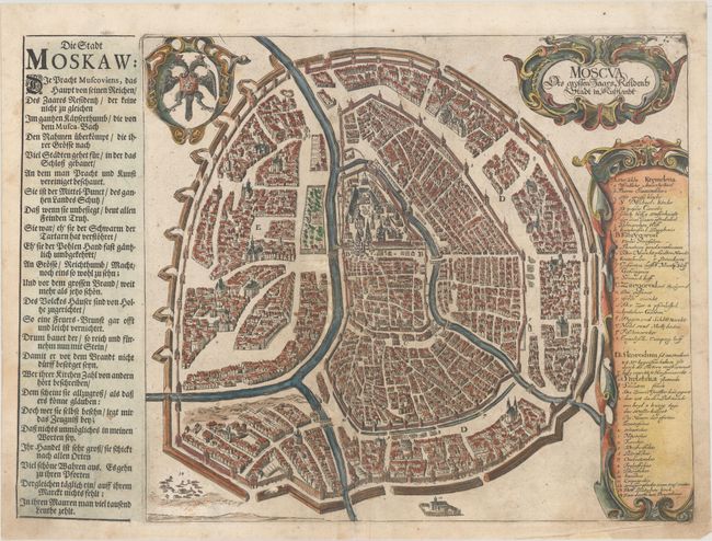
Auction 170, Lot 543
Subject: Moscow, Russia
Olearius, Adam
Moscva des Grossen Zaars, Residents Stadt in Russlandt, 1647
Size: 15.6 x 11.2 inches (39.6 x 28.4 cm)
Estimate: $1,800 - $2,200
Olearius' Important Plan of Moscow
Sold for: $1,200
Closed on 11/14/2018
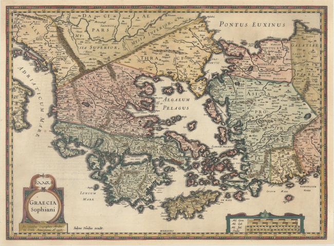
Auction 170, Lot 553
Subject: Greece & Western Turkey
Hondius, Jodocus
Graecia Sophiani, 1618
Size: 19.7 x 14.4 inches (50 x 36.6 cm)
Estimate: $500 - $700
Rare Hondius Version of Ortelius' Map of Greece
Sold for: $250
Closed on 11/14/2018
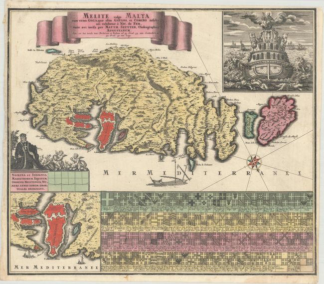
Auction 170, Lot 589
Subject: Malta
Seutter, Matthias
Melite Vulgo Malta cum Vincinis Goza, quae olim Gaulos, et Comino Insulis..., 1730
Size: 22.6 x 19.6 inches (57.4 x 49.8 cm)
Estimate: $1,200 - $1,500
Stunning Map of Malta Featuring the Grand Masters of the Knights of Malta
Sold for: $650
Closed on 11/14/2018
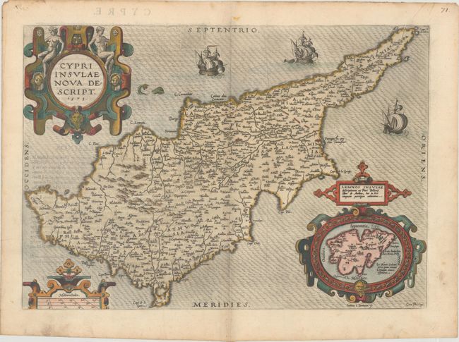
Auction 170, Lot 591
Subject: Cyprus
Ortelius, Abraham
Cypri Insulae Nova Descript., 1573
Size: 19.5 x 13.8 inches (49.5 x 35.1 cm)
Estimate: $1,300 - $1,700
Superb, Decorative Map of Cyprus
Sold for: $900
Closed on 11/14/2018
12 lots