Showing Featured Lots(remove filter)
Filtered by Category:Canada(Show All Categories)
Catalog Archive
356 lots
Page 1 of 8
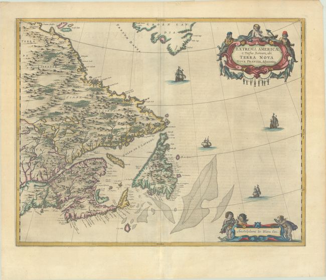
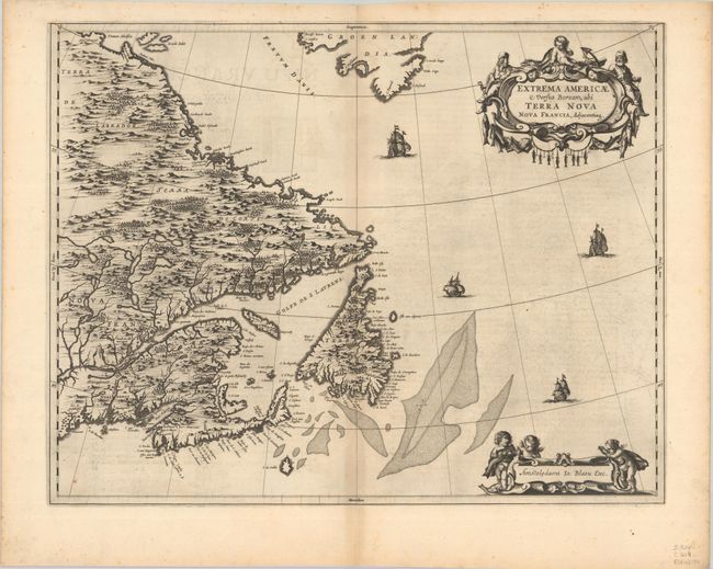
Auction 204, Lot 86
Subject: Eastern Canada
Blaeu, Johannes
Extrema Americae Versus Boream, ubi Terra Nova Nova Francia, Adjacentiaq, 1663
Size: 22.4 x 17.7 inches (56.9 x 45 cm)
Estimate: $1,800 - $2,100
Blaeu's Only Map of Canada, Showing the Canadian Maritimes
Sold for: $1,300
Closed on 6/18/2025
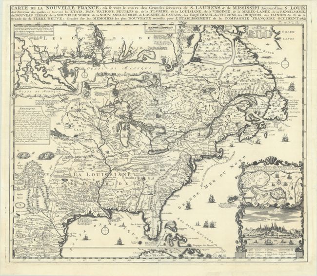
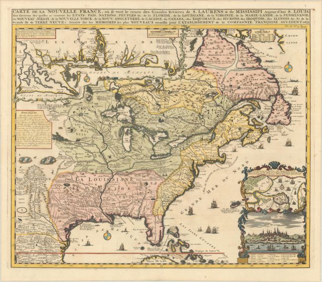
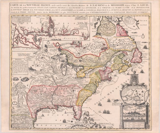
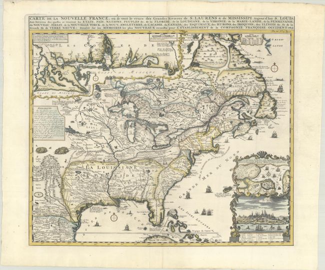
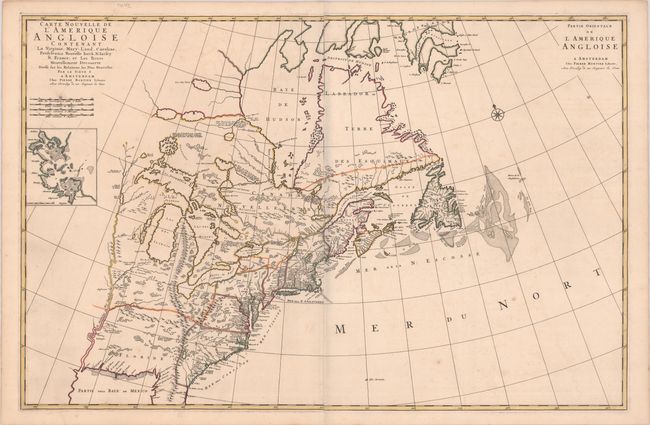
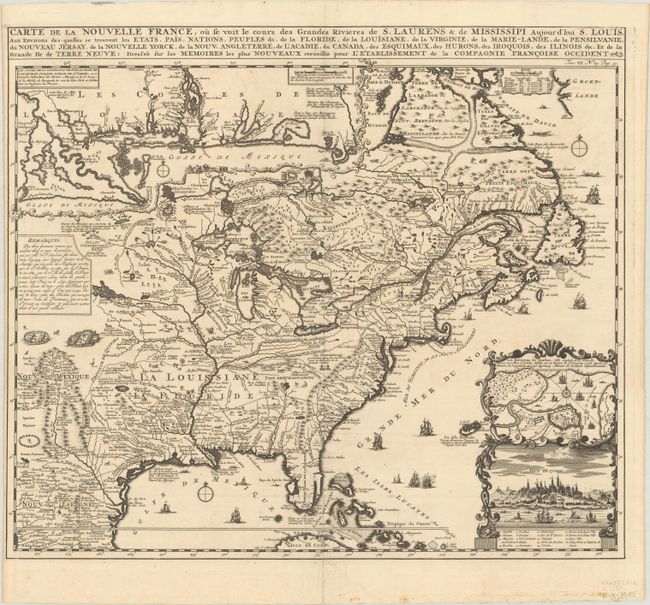
Auction 204, Lot 95
Subject: Colonial Eastern United States & Canada
Chatelain, Henry Abraham
Carte de la Nouvelle France, ou se Voit le Cours des Grandes Rivieres de S. Laurens & de Mississipi Aujour d'hui S. Louis, aux Environs des-quelles se Trouvent les Etats, Pais, Nations, Peuples, &c. de la Floride, de la Louisiane, de la Virginie..., 1719
Size: 19.3 x 16.7 inches (49 x 42.4 cm)
Estimate: $2,200 - $2,500
One of the Most Informative 18th Century Maps of the French Possessions in North America
Unsold
Closed on 6/18/2025
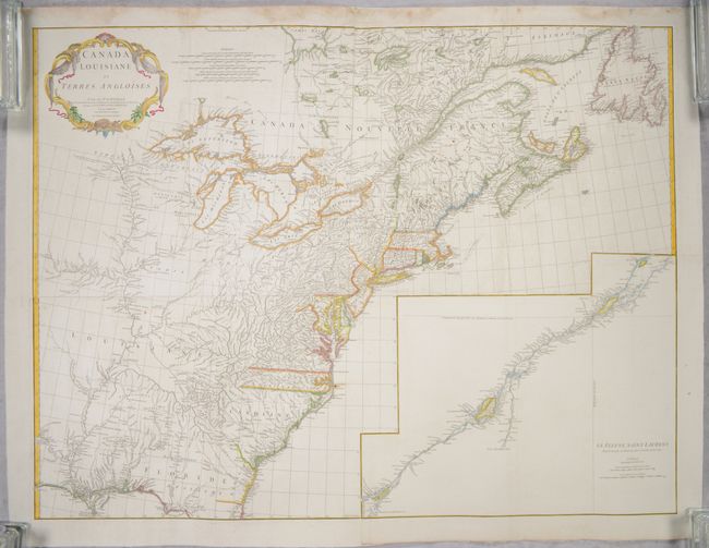
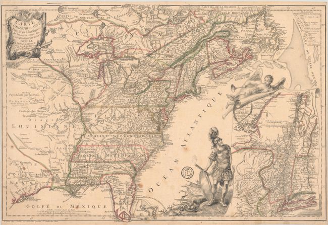
Auction 204, Lot 96
Subject: Colonial Eastern United States & Canada
Anville, Jean Baptiste Bourguignon d'
[On 4 Joined Sheets] Canada Louisiane et Terres Angloises, 1755
Size: 44.8 x 33.9 inches (113.8 x 86.1 cm)
Estimate: $1,400 - $1,700
D'Anville's Spectacular Map of Eastern Seaboard on 4 Joined Sheets
Sold for: $1,000
Closed on 6/18/2025

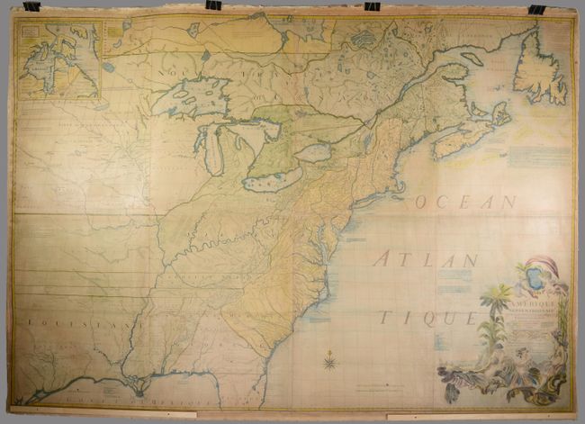
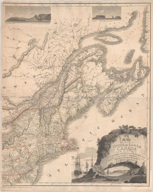
Auction 204, Lot 104
Subject: Northeastern United States & Canada
Bouchette, Joseph
[Eastern Sheet] Map of the Provinces of Upper & Lower Canada with the Adjacent Parts of the United States of America &c. Compiled from the Latest Surveys and Adjusted from the Most Recent and Approved Astronomical Observations, 1815
Size: 24.3 x 30 inches (61.7 x 76.2 cm)
Estimate: $2,400 - $3,000
Eastern Sheet of Bouchette's Rare Map Presenting Lower Canada and New England
Unsold
Closed on 6/18/2025

Auction 203, Lot 86
Subject: Colonial Eastern United States & Canada
Fer, Nicolas de
Carte de la Nouvelle France, ou se Voit le Cours des Grandes Rivieres de S. Laurens & de Mississipi Aujour d'hui S. Louis, aux Environs des-quelles se Trouvent les Etats, Pais, Nations, Peuples, &c. de la Floride, de la Louisiane, de la Virginie..., 1720
Size: 21.9 x 19.8 inches (55.6 x 50.3 cm)
Estimate: $2,750 - $3,500
Striking Map of French Colonial Possessions
Sold for: $2,200
Closed on 4/23/2025
Auction 203, Lot 89
Subject: Colonial Eastern United States & Canada
Mitchell/Le Rouge
Amerique Septentrionale avec les Routes, Distances en Miles, Villages et Etablissements Francois et Anglois par le Docteur Mitchel, 1777
Size: 75 x 52.4 inches (190.5 x 133.1 cm)
Estimate: $9,500 - $12,000
Third French Edition of Mitchell's Monumental Map
Sold for: $5,000
Closed on 4/23/2025
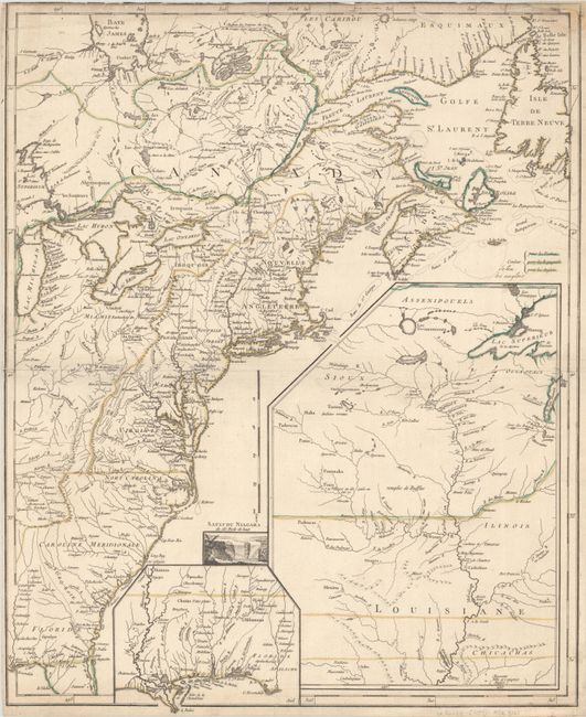
Auction 203, Lot 95
Subject: Colonial Northeastern United States & Canada
Rhode, Johann Cristoph
Theatrum Belli in America Septentrionali II. Foiliis Comprehensum..., 1755
Size: 31.5 x 22 inches (80 x 55.9 cm)
Estimate: $8,000 - $9,500
Scarce German Map Illustrating the French & Indian War
Sold for: $5,000
Closed on 4/23/2025
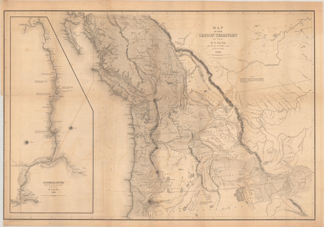
Auction 203, Lot 103
Subject: Northwestern United States & Canada
Wilkes, Charles
Map of the Oregon Territory by the U.S. Ex. Ex., 1841
Size: 34.1 x 22.9 inches (86.6 x 58.2 cm)
Estimate: $1,400 - $1,700
One of the Most Detailed and Important 19th-Century Maps of the American Northwest
Sold for: $1,100
Closed on 4/23/2025
Auction 202, Lot 102
Subject: Colonial Eastern United States & Canada
Chatelain, Henry Abraham
Carte de la Nouvelle France, ou se voit les Cours des Grandes Rivieres de S. Laurens & de Mississipi Aujour d'hui S. Louis, aux Environs des quelles se Trouvent les Etats, Pais, Nations, Peuples &c. de la Floride, de la Louisiane, de la Virginie..., 1719
Size: 19 x 16.5 inches (48.3 x 41.9 cm)
Estimate: $3,000 - $3,750
One of the Most Informative 18th Century Maps of the French Possessions in North America
Sold for: $2,000
Closed on 2/12/2025
Auction 202, Lot 106
Subject: Northeastern United States & Canada
Bouchette, Joseph
[Eastern Sheet] Map of the Provinces of Upper & Lower Canada with the Adjacent Parts of the United States of America &c. Compiled from the Latest Surveys and Adjusted from the Most Recent and Approved Astronomical Observations, 1815
Size: 24.3 x 30 inches (61.7 x 76.2 cm)
Estimate: $2,750 - $3,500
Eastern Sheet of Bouchette's Rare Map Presenting Lower Canada and New England
Unsold
Closed on 2/12/2025
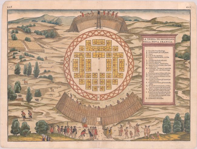
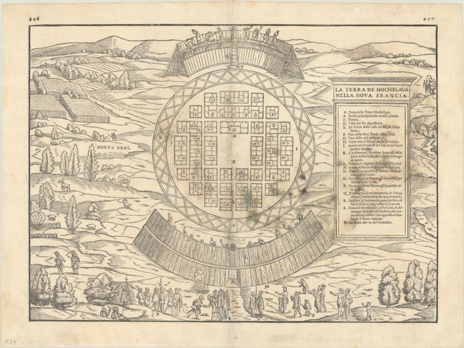
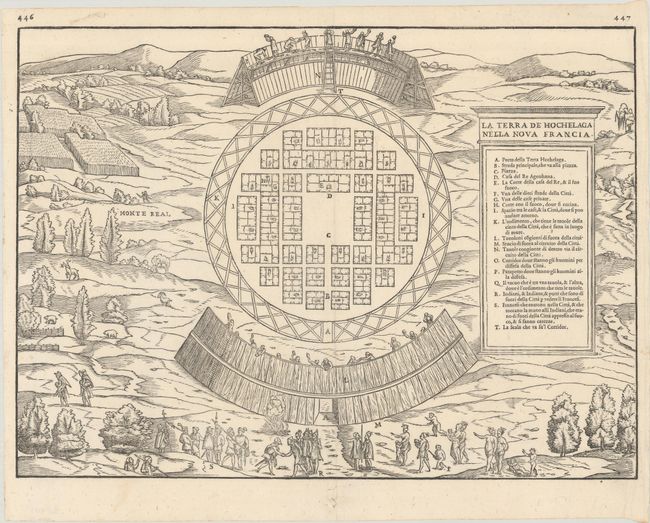
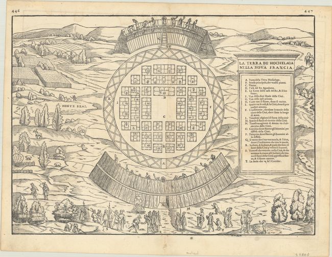
Auction 201, Lot 98
Subject: Montreal, Canada
Gastaldi/Ramusio
La Terra de Hochelaga Nella Nova Francia, 1556
Size: 15.1 x 10.9 inches (38.4 x 27.7 cm)
Estimate: $3,000 - $3,750
Rare First Edition of the First Published Plan of a Settlement in North America
Sold for: $4,750
Closed on 11/20/2024
Auction 201, Lot 105
Subject: Colonial Eastern United States & Canada
Fer, Nicolas de
Carte de la Nouvelle France, ou se Voit le Cours des Grandes Rivieres de S. Laurens & de Mississipi Aujour d'hui S. Louis, aux Environs des-quelles se Trouvent les Etats, Pais, Nations, Peuples, &c. de la Floride, de la Louisiane, de la Virginie..., 1720
Size: 21.9 x 19.8 inches (55.6 x 50.3 cm)
Estimate: $2,750 - $3,500
Striking Map of French Colonial Possessions
Unsold
Closed on 11/20/2024
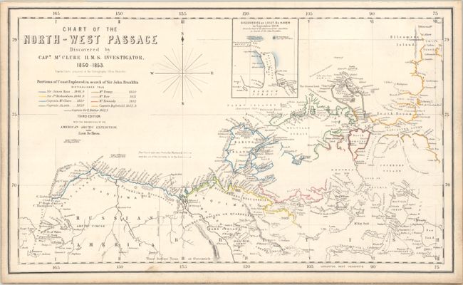
Auction 201, Lot 118
Subject: Canada & Alaska
Johnston, W. & A.K.
Chart of the North-West Passage Discovered by Capt. McClure H.M.S. Investigator, 1850-1853, 1855
Size: 20.5 x 12.2 inches (52.1 x 31 cm)
Estimate: $1,000 - $1,300
One of the First Maps to Depict the Northwest Passage and New Discoveries in the Arctic
Sold for: $2,200
Closed on 11/20/2024
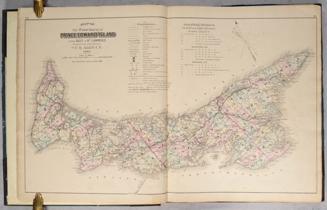
Auction 199, Lot 92
Subject: Prince Edward Island, Canada, Atlases
Illustrated Historical Atlas of the Province of Prince Edward Island..., 1880
Size: 14.6 x 17.8 inches (37.1 x 45.2 cm)
Estimate: $1,500 - $1,800
Highly Detailed Atlas of Prince Edward Island
Sold for: $750
Closed on 9/11/2024
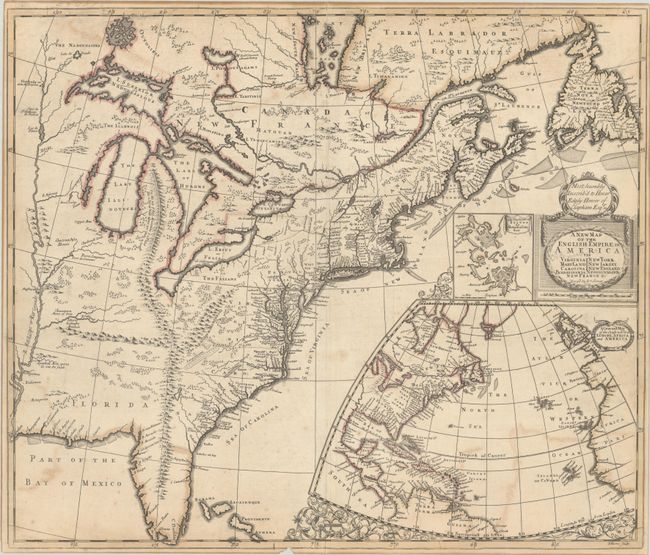
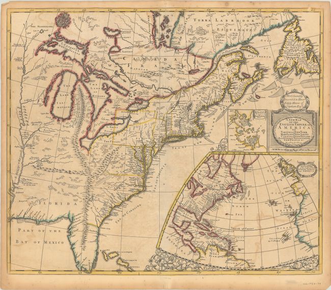
Auction 199, Lot 101
Subject: Colonial Eastern United States & Canada
Senex, John
A New Map of the English Empire in America viz Virginia Maryland Carolina Pennsylvania New York New Iarsey New England Newfoundland New France &c., 1719
Size: 23.3 x 19.8 inches (59.2 x 50.3 cm)
Estimate: $2,400 - $3,000
Senex's Important Map of the American Colonies
Sold for: $1,800
Closed on 9/11/2024
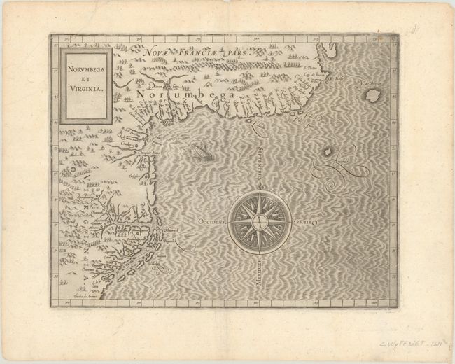
Auction 199, Lot 105
Subject: Colonial Northeastern United States & Canada
Wytfliet, Cornelis
Norumbega et Virginia, 1607
Size: 11.6 x 9.1 inches (29.5 x 23.1 cm)
Estimate: $2,750 - $3,500
Important, Early Map of the East Coast with Mythical City
Sold for: $2,000
Closed on 9/11/2024
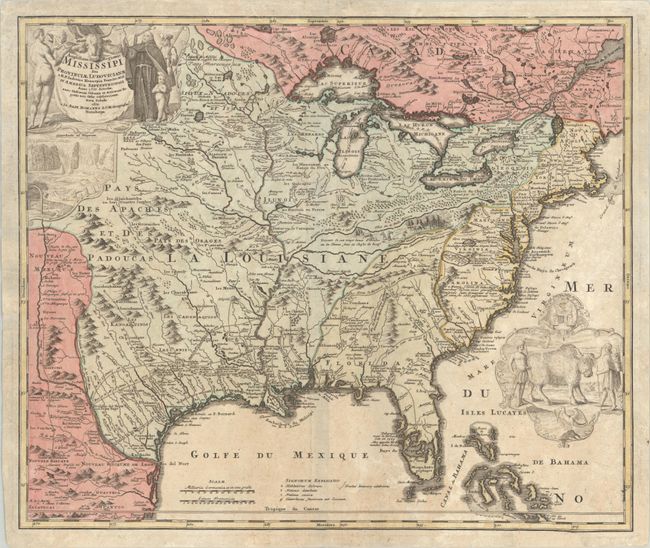
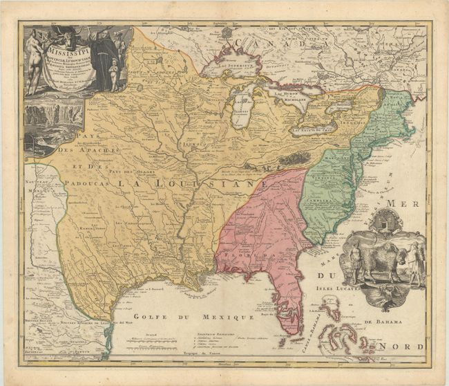
Auction 198, Lot 90
Subject: Colonial Eastern United States & Canada
Homann, Johann Baptist
Amplissimae Regionis Mississipi seu Provinciae Ludovicianae a R.P. Ludovico Hennepin Francisc Miss in America Septentrionali Anno 1687..., 1720
Size: 23 x 19.4 inches (58.4 x 49.3 cm)
Estimate: $2,000 - $2,300
Striking Map of Colonial America with Bison Vignette
Sold for: $1,500
Closed on 6/19/2024

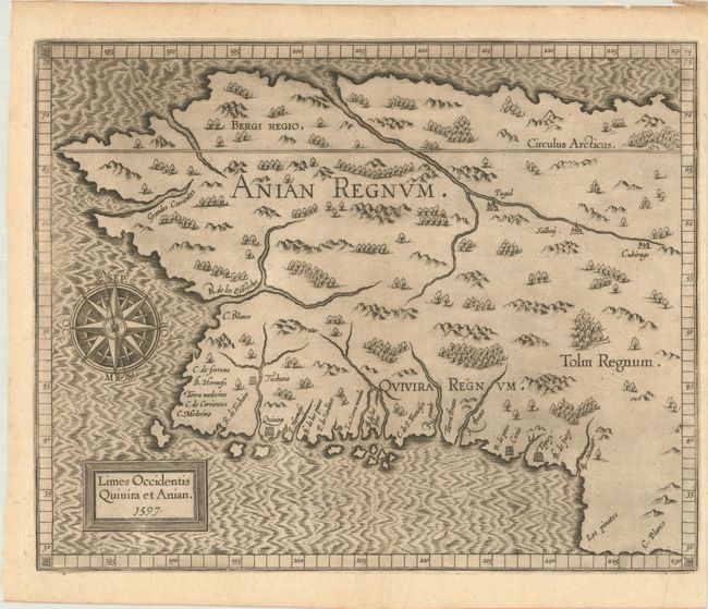
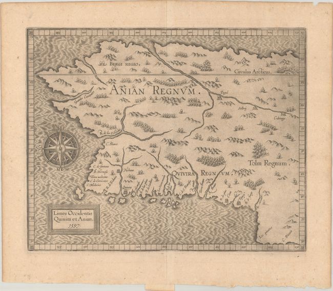
Auction 198, Lot 95
Subject: Alaska & Western Canada
Wytfliet, Cornelis
Limes Occidentis Quivira et Anian, 1607
Size: 11.6 x 9.3 inches (29.5 x 23.6 cm)
Estimate: $1,800 - $2,200
Early and Imaginary Map of Alaska and the Northwest Passage
Sold for: $1,000
Closed on 6/19/2024
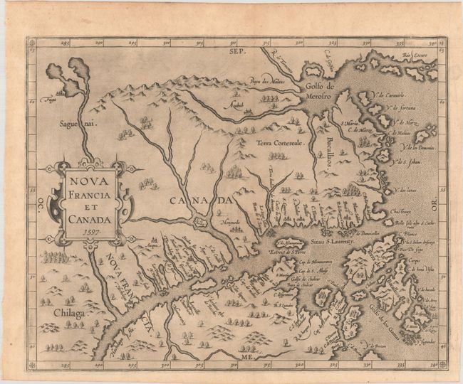
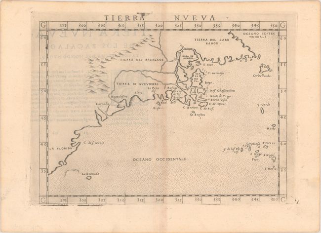
Auction 197, Lot 86
Subject: Eastern Canada
Wytfliet, Cornelis
Nova Francia et Canada, 1597
Size: 11.6 x 9.3 inches (29.5 x 23.6 cm)
Estimate: $2,000 - $2,300
First State of Wytfliet's Landmark Map of Eastern Canada
Sold for: $3,500
Closed on 4/24/2024
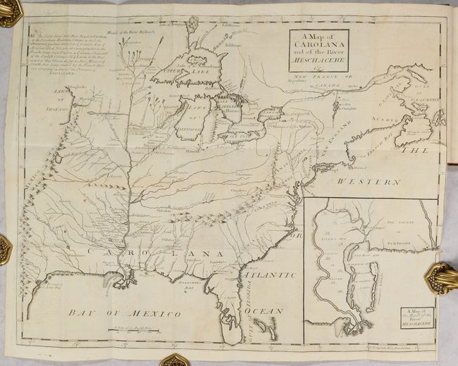
Auction 197, Lot 98
Subject: Colonial Eastern United States & Canada
Coxe, Daniel
[Map in Book] A Map of Carolana and of the River Meschacebe &c. [in] A Description of the English Province of Carolana. By the Spaniards Call'd Florida, and by the French, la Louisiane, 1741
Size: 21.5 x 16.8 inches (54.6 x 42.7 cm)
Estimate: $8,000 - $9,500
First English Depiction of the Mississippi Valley
Sold for: $7,500
Closed on 4/24/2024
Auction 197, Lot 100
Subject: Eastern United States & Canada, Franklin
Crevecoeur, Michel Guillaume De
Carte Generale des Etats-Unis de l'Amerique Septentrionale, Renfermant Aussi Quelques Provinces Angloises Adjacentes, pour les Lettres d'un Cultivateur Ameriquain, 1787
Size: 16.9 x 10.2 inches (42.9 x 25.9 cm)
Estimate: $600 - $750
One of the Earliest Maps to Name Franklinia
Sold for: $450
Closed on 4/24/2024
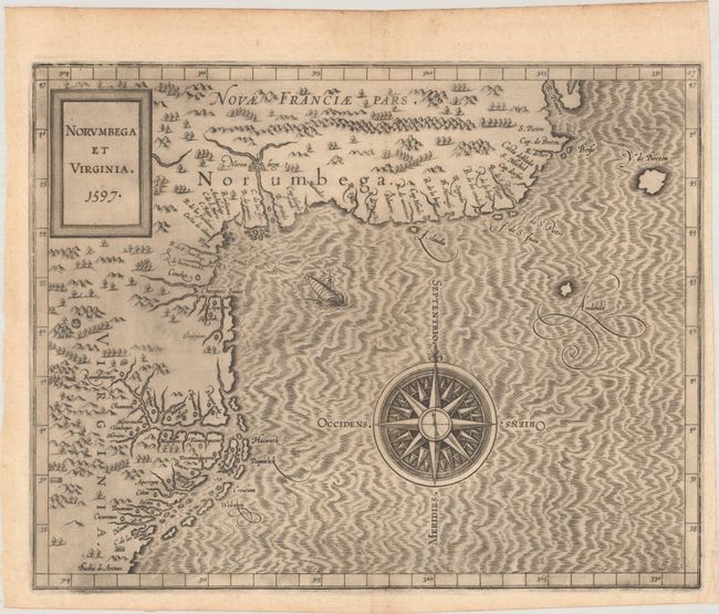
Auction 196, Lot 123
Subject: Colonial Northeastern United States & Canada
Wytfliet, Cornelis
Norumbega et Virginia, 1597
Size: 11.6 x 9.1 inches (29.5 x 23.1 cm)
Estimate: $2,750 - $3,500
Important, Early Map of the East Coast with Mythical City
Sold for: $3,750
Closed on 2/7/2024
Auction 196, Lot 127
Subject: Alaska & Western Canada
Wytfliet, Cornelis
Limes Occidentis Quivira et Anian, 1607
Size: 11.6 x 9.3 inches (29.5 x 23.6 cm)
Estimate: $2,000 - $2,300
Early and Imaginary Map of Alaska and the Northwest Passage
Unsold
Closed on 2/7/2024
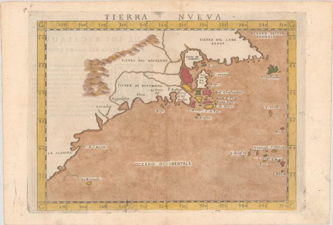
Auction 195, Lot 134
Subject: Eastern United States & Canada
Ruscelli, Girolamo
Tierra Nueva, 1574
Size: 9.7 x 7.1 inches (24.6 x 18 cm)
Estimate: $1,200 - $1,500
Ruscelli's Map of the East Coast
Sold for: $850
Closed on 11/15/2023
Auction 195, Lot 137
Subject: Colonial Eastern United States & Canada
Mitchell/Le Rouge
[On 8 Sheets] Amerique Septentrionale avec les Routes, Distances en Miles, Villages et Etablissements Francois et Anglois..., 1756
Size: 19 x 26.8 inches (48.3 x 68.1 cm)
Estimate: $10,000 - $13,000
French Edition of Mitchell's Monumental Map
Sold for: $7,500
Closed on 11/15/2023
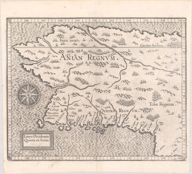
Auction 195, Lot 154
Subject: Alaska & Western Canada
Wytfliet, Cornelis
Limes Occidentis Quivira et Anian, 1597
Size: 11.5 x 9.3 inches (29.2 x 23.6 cm)
Estimate: $1,900 - $2,200
Early and Imaginary Map of Alaska and the Northwest Passage
Sold for: $1,700
Closed on 11/15/2023
Auction 194, Lot 108
Subject: Eastern United States & Canada
Ruscelli, Girolamo
Tierra Nueva, 1574
Size: 9.8 x 7.1 inches (24.9 x 18 cm)
Estimate: $1,200 - $1,500
Ruscelli's Map of the East Coast
Sold for: $750
Closed on 9/13/2023

Auction 194, Lot 109
Subject: Colonial Northeastern United States & Canada
Robert de Vaugondy, Didier
Carte des Pays Connus sous le Nom de Canada, dans Laquelle sont Distinguees les Possessions Francoises, & Angl?..., 1755
Size: 26.4 x 18.9 inches (67.1 x 48 cm)
Estimate: $2,000 - $2,400
A Separately Issued, French Political Propaganda Map at the Outset of the French & Indian War
Sold for: $1,500
Closed on 9/13/2023
Auction 193, Lot 112
Subject: Montreal, Canada
Gastaldi/Ramusio
La Terra de Hochelaga Nella Nova Francia, 1556
Size: 14.4 x 10.6 inches (36.6 x 26.9 cm)
Estimate: $2,000 - $2,300
The First Published Plan of a Settlement in North America
Sold for: $1,500
Closed on 6/21/2023
Auction 193, Lot 119
Subject: Colonial Eastern United States & Canada
Beaurain, Jean Chev. De
Carte de l'Amerique Septle pour Servir a l'Intelligence de la Guerre Entre les Anglois et les Insurgents, 1777
Size: 24.4 x 16.4 inches (62 x 41.7 cm)
Estimate: $7,000 - $8,500
Important Map Published Just Prior to France's Entrance in the Revolutionary War
Sold for: $5,000
Closed on 6/21/2023
Auction 192, Lot 126
Subject: Colonial Eastern United States & Canada
Le Rouge, George Louis
[Canada et Louisiane], 1755
Size: 19.6 x 24.3 inches (49.8 x 61.7 cm)
Estimate: $1,200 - $1,500
Rare First State of Uncommon French & Indian War Map
Sold for: $750
Closed on 4/26/2023
Auction 192, Lot 129
Subject: Colonial Northeastern United States & Canada
Robert de Vaugondy, Didier
Carte des Pays Connus sous le Nom de Canada, dans Laquelle sont Distinguees les Possessions Francoises, & Angl?..., 1755
Size: 26.4 x 18.9 inches (67.1 x 48 cm)
Estimate: $2,300 - $2,750
A Separately Issued, French Political Propaganda Map at the Outset of the French & Indian War
Unsold
Closed on 4/26/2023
Auction 191, Lot 128
Subject: Colonial Eastern United States & Canada
Chatelain, Henry Abraham
Carte de la Nouvelle France, ou se Voit le Cours des Grandes Rivieres de S. Laurens & de Mississipi Aujour d'hui S. Louis, aux Environs des-quelles se Trouvent les Etats, Pais, Nations, Peuples &c. de la Floride..., 1720
Size: 19.1 x 16.6 inches (48.5 x 42.2 cm)
Estimate: $3,000 - $3,750
One of the Most Informative 18th Century Maps of the French Possessions in North America
Sold for: $3,000
Closed on 2/8/2023
Auction 191, Lot 141
Subject: Alaska & Western Canada
Wytfliet, Cornelis
Limes Occidentis Quivira et Anian, 1597
Size: 11.5 x 9.3 inches (29.2 x 23.6 cm)
Estimate: $1,900 - $2,200
Early and Imaginary Map of Alaska and the Northwest Passage
Sold for: $1,400
Closed on 2/8/2023
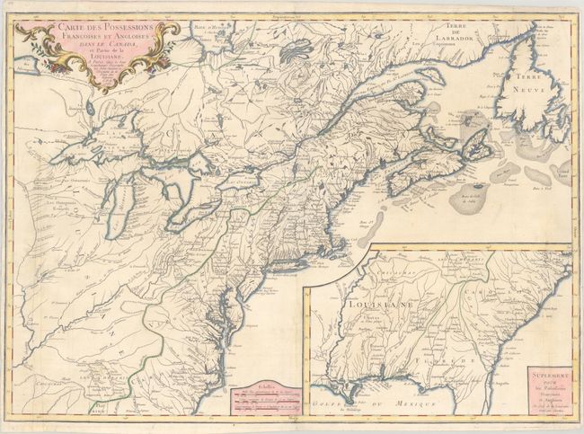
Auction 190, Lot 100
Subject: Colonial Eastern United States & Canada
Longchamp, S. G. (Sieur)
Carte des Possessions Francoises et Angloises dans le Canada, et Partie de la Louisiane, 1756
Size: 30.1 x 21.5 inches (76.5 x 54.6 cm)
Estimate: $1,400 - $1,700
First State of Longchamp's Map of the Theater of the French and Indian War
Sold for: $1,000
Closed on 11/16/2022

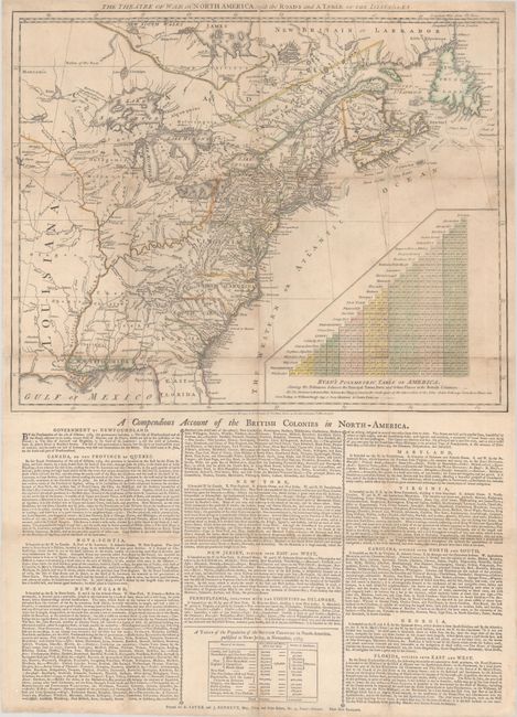
Auction 190, Lot 102
Subject: Colonial Eastern United States & Canada
Sayer & Bennett
The Theatre of War in North America, with the Roads and a Table of the Distances, 1776
Size: 20.1 x 16.1 inches (51.1 x 40.9 cm)
Estimate: $9,500 - $12,000
Early Broadside Informing British Readers of the Brewing War - First State
Sold for: $7,000
Closed on 11/16/2022
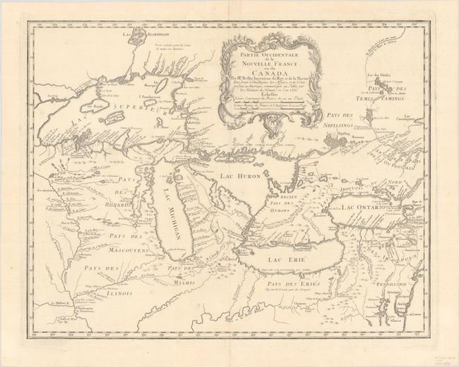
Auction 190, Lot 111
Subject: Colonial Great Lakes
Bellin/Homann Heirs
Partie Occidentale de la Nouvelle France ou du Canada, 1755
Size: 21.3 x 16.9 inches (54.1 x 42.9 cm)
Estimate: $1,600 - $1,900
Influential Map of the Great Lakes
Sold for: $2,100
Closed on 11/16/2022
Auction 189, Lot 107
Subject: Eastern Canada
Blaeu, Johannes
Extrema Americae Versus Boream, ubi Terra Nova Nova Francia, Adjacentiaq, 1664
Size: 22.5 x 17.6 inches (57.2 x 44.7 cm)
Estimate: $1,800 - $2,100
Blaeu's Only Map of Canada, Showing the Canadian Maritimes
Sold for: $1,300
Closed on 9/14/2022
Auction 189, Lot 115
Subject: Colonial Eastern United States & Canada
Mortier, Pierre
Carte Nouvelle de l'Amerique Angloise Contenant la Virginie, Mary-Land, Caroline, Pensylvania Nouvelle Iorck. N: Iarsey N: France, et les Terres Nouvellement Decouerte..., 1700
Size: 35.8 x 23.3 inches (90.9 x 59.2 cm)
Estimate: $2,200 - $2,500
A Map Showing Fascinating Geographic Misconceptions
Sold for: $1,800
Closed on 9/14/2022
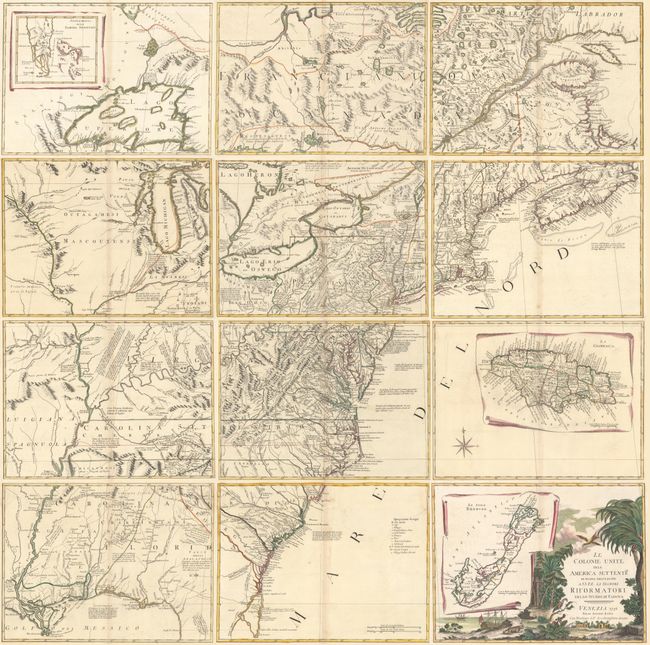
Auction 189, Lot 118
Subject: Colonial Eastern United States & Canada
Zatta, Antonio
[On 12 Sheets] Le Colonie Unite dell' America Settentrle. di Nuova Projezione..., 1778
Size: 16.9 x 12.6 inches (42.9 x 32 cm)
Estimate: $4,750 - $6,000
Impressive 12-Sheet Map of the New "United Colonies"
Sold for: $3,000
Closed on 9/14/2022
Auction 188, Lot 106
Subject: Colonial Eastern United States & Canada
Sayer & Bennett
The Theatre of War in North America, with the Roads and a Table of the Distances, 1776
Size: 20.1 x 16.1 inches (51.1 x 40.9 cm)
Estimate: $10,000 - $13,000
Early Broadside Informing British Readers of the Brewing War - First State
Unsold
Closed on 6/22/2022
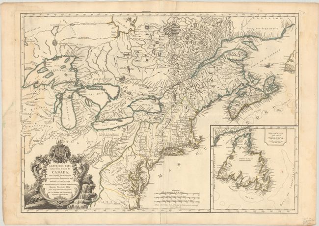
Auction 187, Lot 131
Subject: Colonial Northeastern United States & Canada, Great Lakes
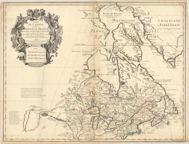
Delisle, Guillaume
Carte du Canada ou de la Nouvelle France et des Decouvertes qui y ont ete Faites Dressee sur Plusieurs Observations et sur un Grand Nombre de Relations Imprimees ou Manuscrites, 1703
Size: 25.6 x 19.8 inches (65 x 50.3 cm)
Estimate: $3,000 - $3,750
Rare First State of Delisle's Seminal Map of Canada and the Great Lakes
Sold for: $4,750
Closed on 4/27/2022
Auction 186, Lot 126
Subject: Montreal, Canada
Gastaldi/Ramusio
La Terra de Hochelaga Nella Nova Francia, 1556
Size: 14.5 x 10.6 inches (36.8 x 26.9 cm)
Estimate: $2,400 - $3,000
The First Published Plan of a Settlement in North America
Sold for: $3,000
Closed on 2/9/2022
Auction 186, Lot 131
Subject: Colonial Eastern United States & Canada
Chatelain, Henry Abraham
Carte de la Nouvelle France, ou se voit le Cours des Grandes Rivieres de S. Laurens & de Mississipi Aujour d'hui S. Louis, aux Environs des-quelles se Trouvent les Etats, Pais, Nations, Peuples &c..., 1720
Size: 19.3 x 16.6 inches (49 x 42.2 cm)
Estimate: $2,400 - $3,000
One of the Most Informative 18th Century Maps of the French Possessions in North America
Sold for: $2,100
Closed on 2/9/2022
Auction 186, Lot 137
Subject: Eastern United States & Canada
Lattre, Jean
Carte des Etats-Unis de l'Amerique Suivant le Traite de Paix de ... Dediee et Presentee a S. Excellence Mr. Benjamin Franklin..., 1791
Size: 30 x 21.9 inches (76.2 x 55.6 cm)
Estimate: $5,500 - $7,000
First French Map of the New United States
Sold for: $7,000
Closed on 2/9/2022
Auction 186, Lot 143
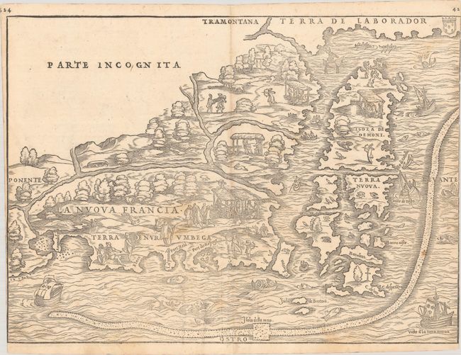
Subject: Colonial Northeastern United States & Canada
Gastaldi/Ramusio
La Nuova Francia, 1556
Size: 14.8 x 10.8 inches (37.6 x 27.4 cm)
Estimate: $5,000 - $6,500
Rare First State of the First Printed Map to Focus on New England and New France
Sold for: $3,500
Closed on 2/9/2022
Auction 185, Lot 121
Subject: Montreal, Canada
Gastaldi/Ramusio
La Terra de Hochelaga nella Nova Francia, 1556
Size: 14.6 x 10.6 inches (37.1 x 26.9 cm)
Estimate: $2,200 - $2,500
The First Published Plan of a Settlement in North America
Sold for: $2,750
Closed on 11/17/2021
Auction 185, Lot 126
Subject: Colonial Eastern United States & Canada
Homann, Johann Baptist
Amplissimae Regionis Mississipi seu Provinciae Ludovicianae a R.P. Ludovico Hennepin Francisc Miss. in America Septentrionali Anno 1687..., 1730
Size: 22.9 x 19.3 inches (58.2 x 49 cm)
Estimate: $2,000 - $2,300
Striking Map of Colonial America with Bison Vignette
Sold for: $1,500
Closed on 11/17/2021
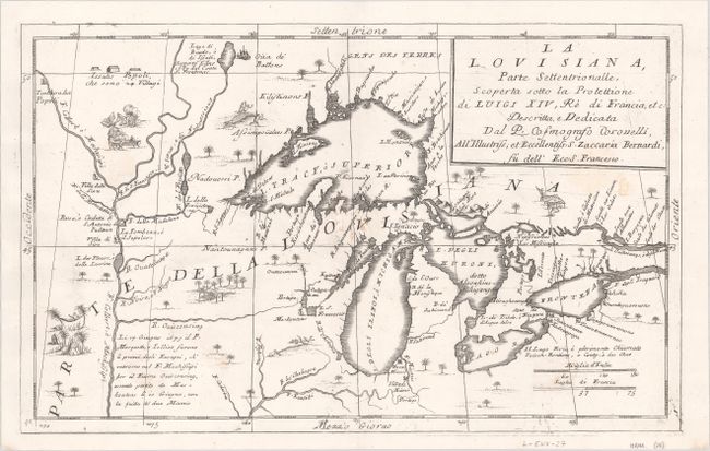
Auction 185, Lot 150
Subject: Colonial Central United States & Canada, Great Lakes
Coronelli, Vincenzo Maria
La Louisiana, Parte Settentrionalle, Scoperta Sotto la Protettione di Luigi XIV, Re di Francia, Etc. , 1696
Size: 16.4 x 10.1 inches (41.7 x 25.7 cm)
Estimate: $2,750 - $3,500
Coronelli's Important Map of the Great Lakes & Upper Mississippi River Valley
Sold for: $4,500
Closed on 11/17/2021
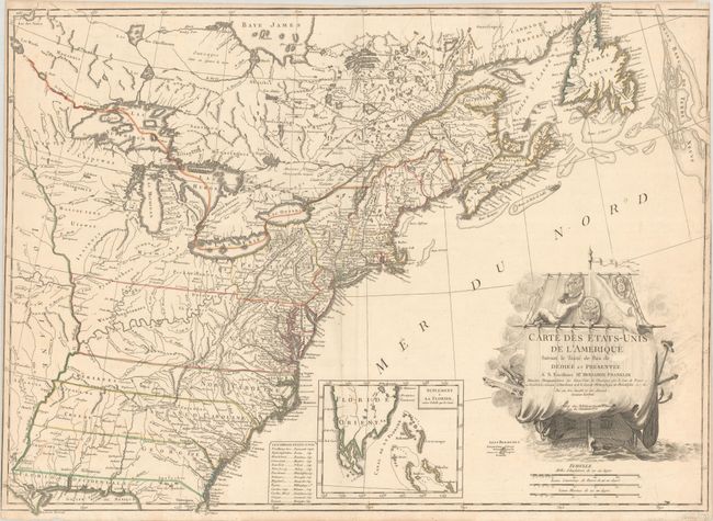
Auction 184, Lot 135
Subject: Colonial Eastern United States & Canada
Senex, John
A New Map of the English Empire in America viz Virginia Maryland Carolina Pennsylvania New York New Iarsey New England Newfoundland New France &c. , 1719
Size: 23.1 x 19.7 inches (58.7 x 50 cm)
Estimate: $2,000 - $2,300
Important Map of the American Colonies
Sold for: $1,500
Closed on 9/15/2021
356 lots
Page 1 of 8