Showing Featured Lots(remove filter)
Filtered by Category:Asia, Middle East, Holy Land(Show All Categories)
Catalog Archive
1029 lots
Page 1 of 21
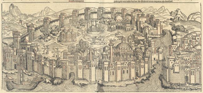
Auction 204, Lot 556
Subject: Istanbul, Turkey
Schedel, Hartmann
Folium CXXX - Constantinopolis, 1493
Size: 20.9 x 9.4 inches (53.1 x 23.9 cm)
Estimate: $1,400 - $1,700
One of the Earliest Available Views of Constantinople, from Schedel's Nuremberg Chronicle
Unsold
Closed on 6/18/2025
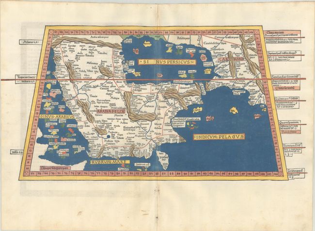
Auction 204, Lot 567
Subject: Arabia
Ptolemy/Holle
[Title on Verso] Sexta Asie Tabula Continet Arabiam Felicem..., 1482
Size: 22.3 x 11.3 inches (56.6 x 28.7 cm)
Estimate: $55,000 - $65,000
One of the Earliest & Most Desirable Printed Maps of Arabia
Unsold
Closed on 6/18/2025
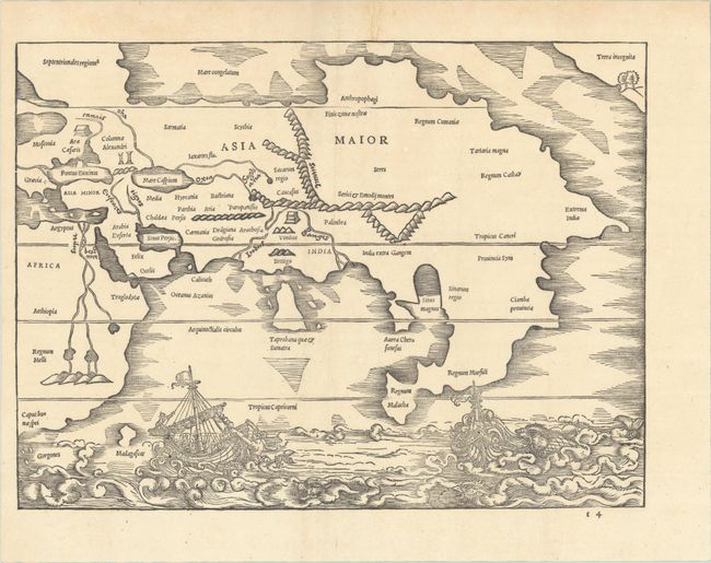
Auction 204, Lot 573
Subject: Asia
Solinus, Caius Julius
[Asia Maior], 1538
Size: 13 x 9.7 inches (33 x 24.6 cm)
Estimate: $2,000 - $2,300
Earliest Depiction of the Northwest Coast of America on a Printed Map
Unsold
Closed on 6/18/2025
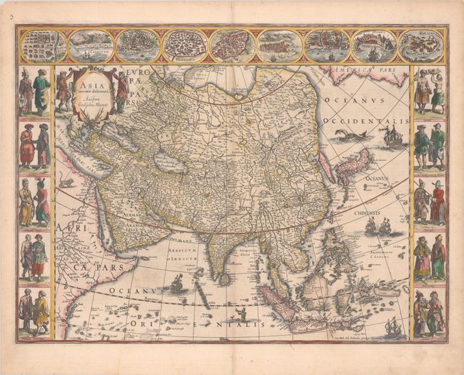
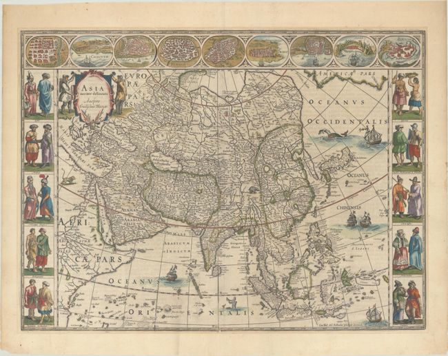
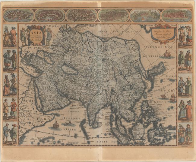
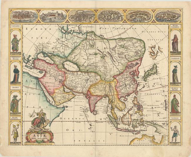
Auction 204, Lot 577
Subject: Asia
Blaeu, Willem
Asia Noviter Delineata, 1634
Size: 22 x 16.3 inches (55.9 x 41.4 cm)
Estimate: $3,000 - $3,750
Magnificent Carte-a-Figures Map of Asia
Sold for: $2,000
Closed on 6/18/2025
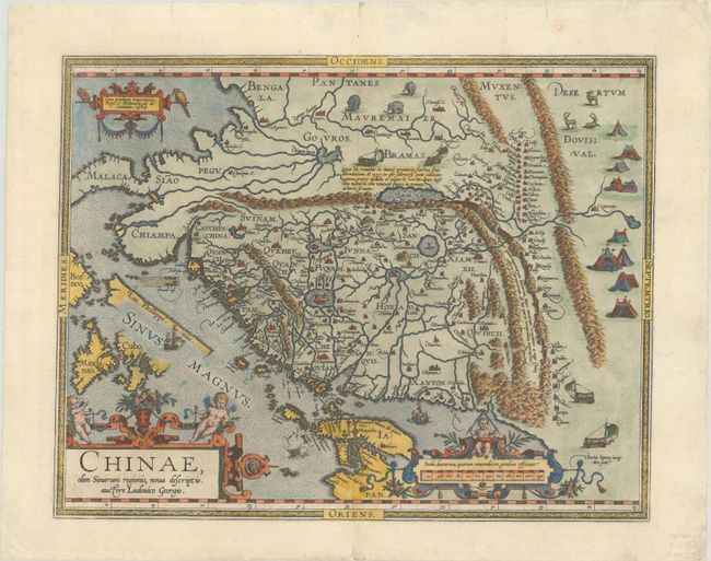
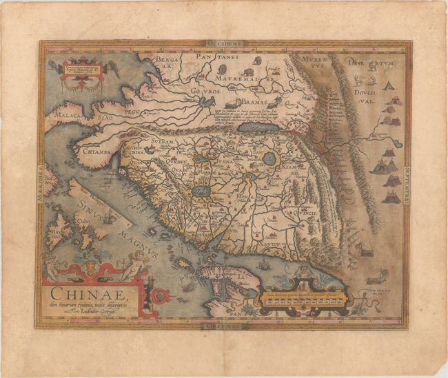
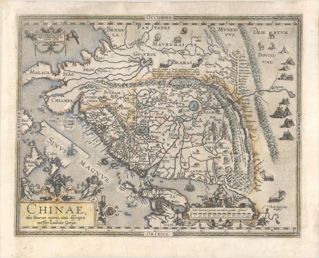
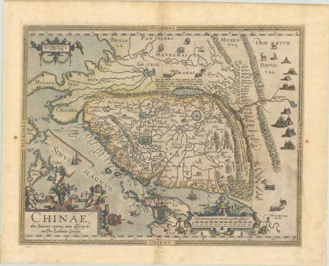
Auction 204, Lot 589
Subject: China
Ortelius, Abraham
Chinae, olim Sinarum Regionis, Nova Descriptio. Auctore Ludovico Georgio, 1584
Size: 18.5 x 14.5 inches (47 x 36.8 cm)
Estimate: $4,000 - $5,000
The First European-Printed Map of China
Unsold
Closed on 6/18/2025
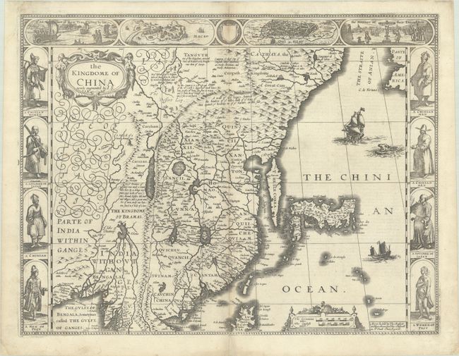
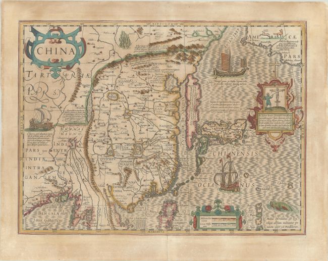
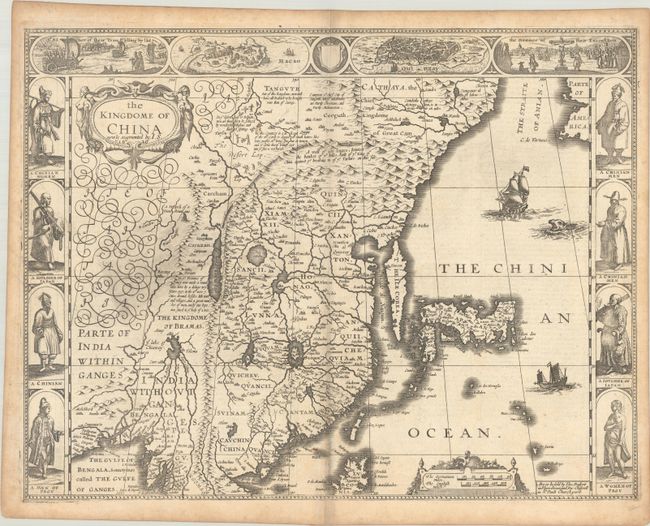
Auction 204, Lot 594
Subject: China, Korea & Japan
Speed, John
The Kingdome of China Newly Augmented, 1626
Size: 20.3 x 15.6 inches (51.6 x 39.6 cm)
Estimate: $3,000 - $3,750
Speed's Striking Carte-a-Figures Map of China with the Island of Korea
Unsold
Closed on 6/18/2025

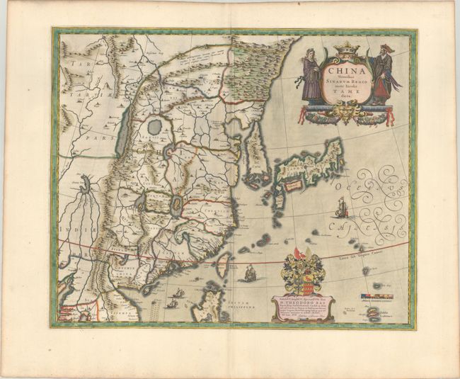
Auction 204, Lot 595
Subject: China, Korea & Japan
Blaeu, (Family)
China Veteribus Sinarum Regio nunc Incolis Tame Dicta, 1640
Size: 19.6 x 16.1 inches (49.8 x 40.9 cm)
Estimate: $1,100 - $1,400
Attractive Example of Blaeu's Map of China Featuring Fictitious Lakes and Rivers
Sold for: $700
Closed on 6/18/2025
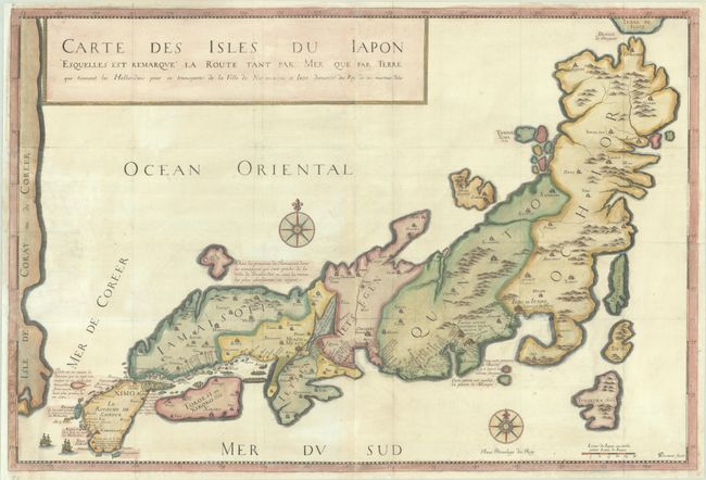
Auction 204, Lot 601
Subject: Japan
Tavernier, Jean Baptiste
Carte des Isles du Iapon Esquelles est Remarque la Route tant par Mer que par Terre que Tiennent les Hollandois pour se Transporter de la Ville de Nangasaqui a Iedo..., 1679
Size: 30.4 x 20.5 inches (77.2 x 52.1 cm)
Estimate: $800 - $1,000
Rare, First Edition Map of Japan
Sold for: $600
Closed on 6/18/2025
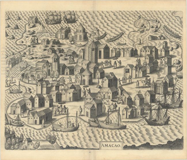
Auction 204, Lot 608
Subject: East Indies - Indonesia, Singapore, & Macao
Bry, Johann Theodore de
[Petits Voyages, Part VIII] Achter Theil der Orientalischen Indien / Begreiffend Erstlich ein Historische Beschreibung der Schiffart..., 1606
Size: 7.8 x 11.8 inches (19.8 x 30 cm)
Estimate: $2,750 - $3,500
Complete Disbound Example of Petits Voyages, Part VIII, with Map of Strait of Singapore and Plan of Macao
Sold for: $2,000
Closed on 6/18/2025
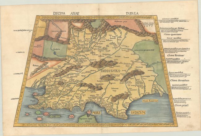
Auction 204, Lot 610
Subject: India
Ptolemy/Waldseemuller
Decima Asiae Tabula, 1513
Size: 22.3 x 14 inches (56.6 x 35.6 cm)
Estimate: $2,000 - $2,300
Early Ptolemaic Map of India
Sold for: $1,200
Closed on 6/18/2025
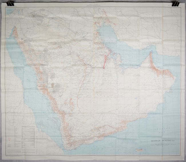
Auction 203, Lot 623
Subject: Arabian Peninsula
U.S. Department of Interior
Arabian Peninsula, 1958
Size: 52.5 x 45 inches (133.4 x 114.3 cm)
Estimate: $2,000 - $2,300
Very Rare Early Issue of Foundational Geological Map of the Arabian Peninsula
Sold for: $1,000
Closed on 4/23/2025
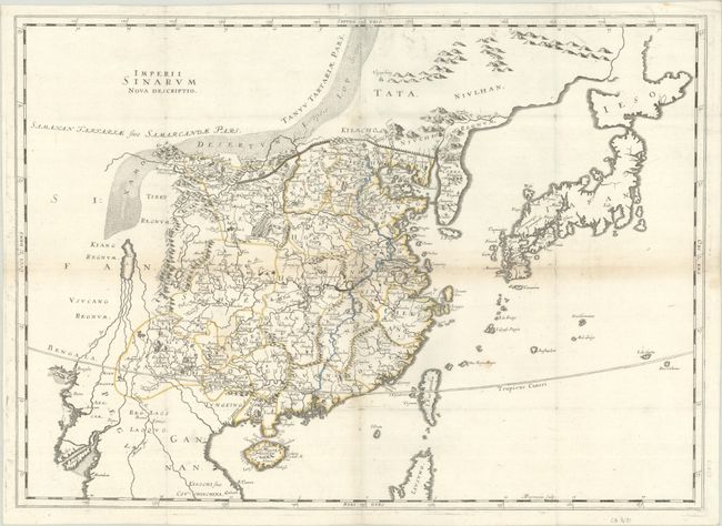
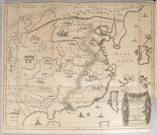
Auction 203, Lot 655
Subject: China, Korea & Japan
Thevenot, Melchisedech
Imperii Sinarum Nova Descriptio, 1666
Size: 25 x 18 inches (63.5 x 45.7 cm)
Estimate: $1,600 - $1,900
Rare Map of China Based on Blaeu
Sold for: $500
Closed on 4/23/2025
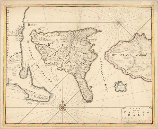
Auction 203, Lot 670
Subject: Bali, Indonesia
Valentyn, Francois
Kaart van het Eyland Bali, 1726
Size: 22.1 x 17.6 inches (56.1 x 44.7 cm)
Estimate: $1,100 - $1,400
Striking Early Map of Bali
Unsold
Closed on 4/23/2025

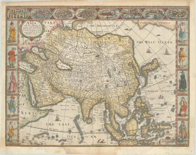
Auction 202, Lot 628
Subject: Asia
Speed, John
Asia with the Islands Adjoyning Described, the Atire of the People, & Townes of Importance, All of Them Newly Augmented, 1626
Size: 20.3 x 15.6 inches (51.6 x 39.6 cm)
Estimate: $2,000 - $2,300
The First English Printed Map of Asia
Sold for: $1,500
Closed on 2/12/2025

Auction 202, Lot 630
Subject: Asia
Blaeu, Willem
Asia Noviter Delineata, 1663
Size: 21.9 x 16.2 inches (55.6 x 41.1 cm)
Estimate: $3,250 - $4,000
Magnificent Carte-a-Figures Map of Asia in Full Contemporary Color
Unsold
Closed on 2/12/2025
Auction 202, Lot 639
Subject: China
Ortelius, Abraham
Chinae, olim Sinarum Regionis, Nova Descriptio. Auctore Ludovico Georgio, 1584
Size: 18.7 x 14.5 inches (47.5 x 36.8 cm)
Estimate: $3,000 - $3,750
The First European-Printed Map of China in Full Contemporary Color
Unsold
Closed on 2/12/2025
Auction 202, Lot 645
Subject: China, Korea & Japan
Mercator/Hondius
China, 1639
Size: 18.1 x 13.5 inches (46 x 34.3 cm)
Estimate: $2,000 - $2,300
Hondius' Map of China, Korea, and Japan in Full Contemporary Color
Sold for: $1,300
Closed on 2/12/2025
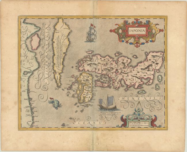
Auction 202, Lot 650
Subject: Japan & Korea
Mercator/Hondius
Iaponia, 1623
Size: 17.6 x 13.6 inches (44.7 x 34.5 cm)
Estimate: $1,100 - $1,400
Hondius' Richly Ornamented Map of Japan
Sold for: $750
Closed on 2/12/2025
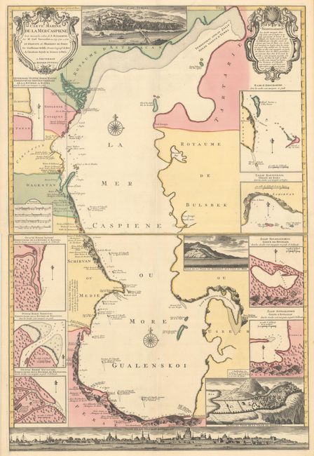
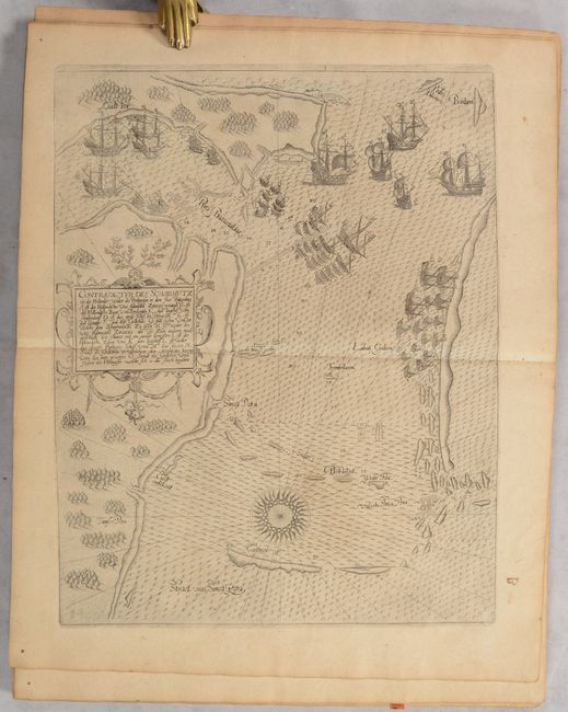
Auction 201, Lot 639
Subject: Caspian Sea
Ottens
[On 2 Sheets] Carte Marine de la Mer Caspiene Levee Suivant les Ordres de S.M. Czariene, par Mr. Carl Vanverden en 1719, 1720, et 1721..., 1723
Size: 23.5 x 17.9 inches (59.7 x 45.5 cm)
Estimate: $1,100 - $1,400
Superb Map of the Caspian Sea with Panoramic Views of the Region
Unsold
Closed on 11/20/2024

Auction 201, Lot 641
Subject: Asia
Hondius/Jansson
Asia Recens Summa Cura Delineata, 1632
Size: 22 x 16.2 inches (55.9 x 41.1 cm)
Estimate: $2,000 - $2,300
Jansson's Spectacular Carte-a-Figure Map of Asia
Sold for: $1,000
Closed on 11/20/2024

Auction 201, Lot 642
Subject: Asia
Blaeu, Willem
Asia Noviter Delineata, 1634
Size: 22 x 16.3 inches (55.9 x 41.4 cm)
Estimate: $3,000 - $3,750
Magnificent Carte-a-Figures Map of Asia
Unsold
Closed on 11/20/2024

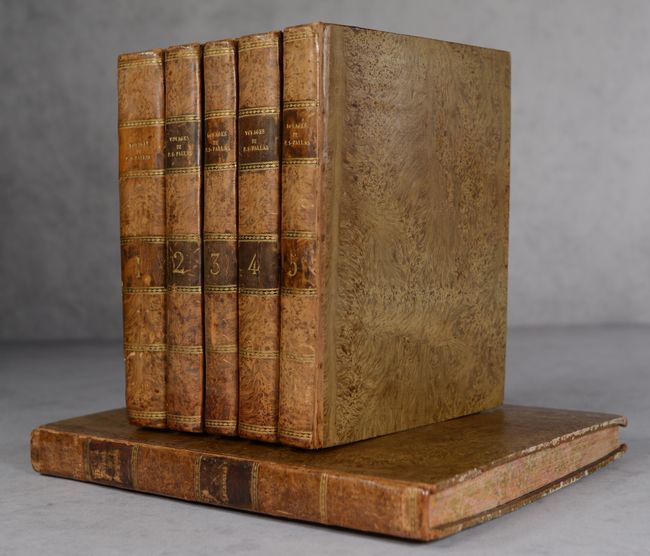
Auction 201, Lot 655
Subject: Russia in Asia
[5 Volumes & Atlas] Voyages de M.P.S. Pallas, en Differentes Provinces de l'Empire de Russie, et dans l'Asie Septentrionale [Tomes I-V]... [and] Voyages du Professeur Pallas ... Nouvelle Edition ... Tome Neuvieme, (Planches.), 1788-93
Size: See Description
Estimate: $3,500 - $4,250
Superb Work on 18th Century Russia with over 100 Maps and Plates
Unsold
Closed on 11/20/2024

Auction 201, Lot 657
Subject: China
Nieuhoff, Johann
L'Ambassade de la Compagnie Orientale des Provinces Unies vers l'Empereur de la Chine, ou Grand Cam de Tartarie..., 1665
Size: 13.4 x 8.8 inches (34 x 22.4 cm)
Estimate: $2,400 - $3,000
Nieuhoff's Important Description of the Chinese Empire
Unsold
Closed on 11/20/2024
Auction 201, Lot 663
Subject: China, Korea & Japan
Blaeu, (Family)
China Veteribus Sinarum Regio nunc Incolis Tame Dicta, 1640
Size: 19.6 x 16.1 inches (49.8 x 40.9 cm)
Estimate: $1,400 - $1,700
Attractive Example of Blaeu's Map of China Featuring Fictitious Lakes and Rivers
Unsold
Closed on 11/20/2024
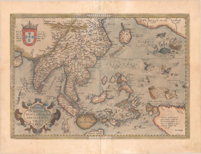
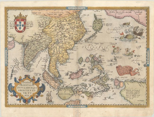
Auction 201, Lot 682
Subject: Southern & Southeast Asia
Ortelius, Abraham
Indiae Orientalis, Insularumque Adiacientium Typus, 1579
Size: 19.8 x 13.8 inches (50.3 x 35.1 cm)
Estimate: $2,400 - $3,000
Ortelius' Important Map of Southeast Asia in Full Contemporary Color
Sold for: $1,800
Closed on 11/20/2024
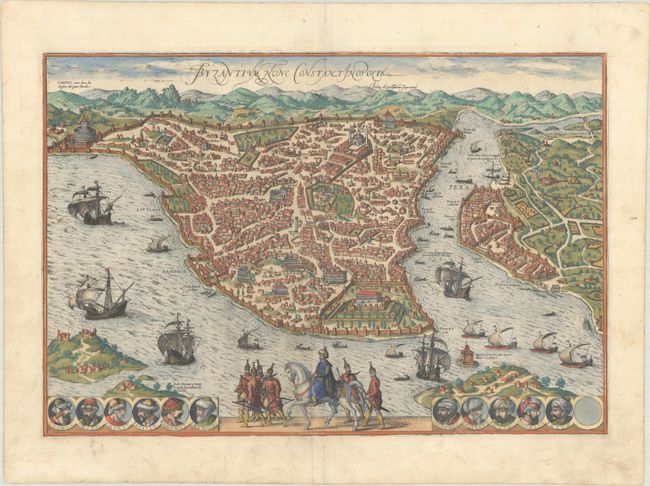
Auction 199, Lot 573
Subject: Istanbul, Turkey
Braun & Hogenberg
Byzantium, nunc Constantinopolis, 1572
Size: 19.1 x 12.9 inches (48.5 x 32.8 cm)
Estimate: $1,900 - $2,300
Superb Bird's-Eye View During the Golden Age of the Ottoman Empire
Sold for: $3,250
Closed on 9/11/2024
Auction 199, Lot 597
Subject: Asia
Speed, John
Asia with the Islands Adjoyning Described, the Atire of the People, & Townes of Importance, All of Them Newly Augmented, 1626
Size: 20.3 x 15.6 inches (51.6 x 39.6 cm)
Estimate: $2,300 - $2,750
The First English Printed Map of Asia
Unsold
Closed on 9/11/2024
Auction 199, Lot 600
Subject: Asia
Blaeu, Willem
Asia Noviter Delineata, 1663
Size: 21.9 x 16.2 inches (55.6 x 41.1 cm)
Estimate: $3,250 - $4,000
Magnificent Carte-a-Figures Map of Asia in Full Contemporary Color
Unsold
Closed on 9/11/2024

Auction 199, Lot 615
Subject: China
Ortelius, Abraham
Chinae, olim Sinarum Regionis, Nova Descriptio. Auctore Ludovico Georgio, 1584
Size: 18.7 x 14.5 inches (47.5 x 36.8 cm)
Estimate: $3,000 - $3,750
The First European-Printed Map of China in Full Contemporary Color
Unsold
Closed on 9/11/2024
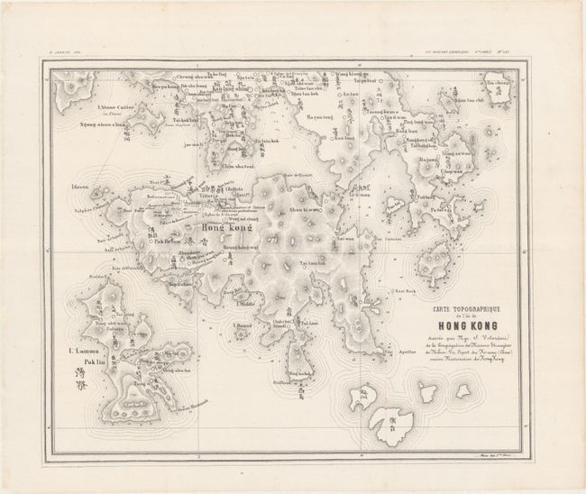
Auction 199, Lot 619
Subject: Hong Kong, China
Carte Topographique de l'Ile de Hong Kong, 1874
Size: 11.9 x 9.9 inches (30.2 x 25.1 cm)
Estimate: $1,500 - $2,000
Volonteri's Scarce Bilingual Map of Hong Kong
Sold for: $3,250
Closed on 9/11/2024
Auction 199, Lot 622
Subject: China, Korea & Japan
Speed, John
The Kingdome of China Newly Augmented, 1626
Size: 20.2 x 15.6 inches (51.3 x 39.6 cm)
Estimate: $3,000 - $3,750
Speed's Striking Carte-a-Figures Map of China with the Island of Korea
Sold for: $2,200
Closed on 9/11/2024
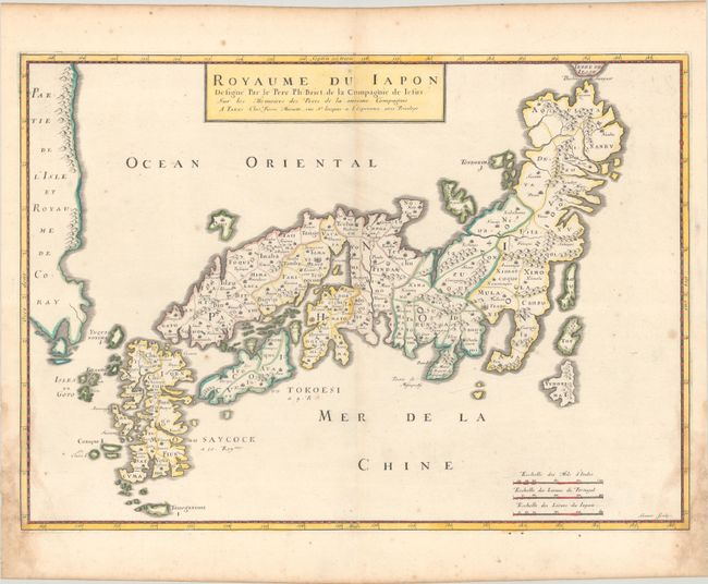
Auction 199, Lot 630
Subject: Japan & Korea
Briet, Philippe
Royaume du Iapon Designe par le Pere Ph: Briet, de la Compagnie de Iesus…, 1658
Size: 20.5 x 14.6 inches (52.1 x 37.1 cm)
Estimate: $1,000 - $1,300
Uncommon French Map of Japan
Sold for: $500
Closed on 9/11/2024
Auction 199, Lot 637
Subject: East Indies - Indonesia, Singapore, & Macao
Bry, Johann Theodore de
[Petits Voyages, Part VIII] Achter Theil der Orientalischen Indien / Begreiffend Erstlich ein Historische Beschreibung der Schiffart..., 1606
Size: 7.9 x 12.3 inches (20.1 x 31.2 cm)
Estimate: $4,750 - $5,500
Complete Disbound Example of Petits Voyages, Part VIII, with Map of Strait of Singapore and Plan of Macao
Sold for: $2,900
Closed on 9/11/2024
Auction 199, Lot 646
Subject: Southern & Southeast Asia
Ortelius, Abraham
Indiae Orientalis, Insularumque Adiacientium Typus, 1579
Size: 19.6 x 13.7 inches (49.8 x 34.8 cm)
Estimate: $2,400 - $3,000
Ortelius' Important Map of Southeast Asia
Sold for: $1,600
Closed on 9/11/2024
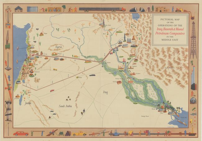
Auction 198, Lot 574
Subject: Middle East
Pictorial Map of the Operations of the Iraq, Basrah & Mosul Petroleum Companies in the Middle East, 1952
Size: 29.9 x 20.6 inches (75.9 x 52.3 cm)
Estimate: $1,200 - $1,500
Rare Pictorial Oil Map of the Fertile Crescent
Sold for: $600
Closed on 6/19/2024
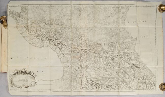
Auction 198, Lot 591
Subject: Caucasus
[Map Bound in 2 Volumes] Neue Carte des Caucasus Groestentheils aus Gueldenstaedts... [in] Reisen durch Russland und im Caucasischen Geburge..., 1787-91
Size: 9.5 x 7.5 inches (24.1 x 19.1 cm)
Estimate: $7,000 - $8,000
Rare and Important Study on the Caucasus with 27 Maps and Plates
Sold for: $5,000
Closed on 6/19/2024

Auction 198, Lot 592
Subject: Caspian Sea
Ottens
[On 2 Sheets] Carte Marine de la Mer Caspiene Levee Suivant les Ordres de S.M. Czariene, par Mr. Carl Vanverden en 1719, 1720, et 1721..., 1723
Size: 23.5 x 17.9 inches (59.7 x 45.5 cm)
Estimate: $1,200 - $1,500
Superb Map of the Caspian Sea with Panoramic Views of the Region
Unsold
Closed on 6/19/2024
Auction 198, Lot 595
Subject: Asia
Hondius/Jansson
Asia Recens Summa Cura Delineata, 1632
Size: 22 x 16.2 inches (55.9 x 41.1 cm)
Estimate: $2,750 - $3,500
Jansson's Spectacular Carte-a-Figure Map of Asia
Unsold
Closed on 6/19/2024
Auction 198, Lot 608
Subject: Russia in Asia
[5 Volumes & Atlas] Voyages de M.P.S. Pallas, en Differentes Provinces de l'Empire de Russie, et dans l'Asie Septentrionale [Tomes I-V]... [and] Voyages du Professeur Pallas ... Nouvelle Edition ... Tome Neuvieme, (Planches.), 1788-93
Size: See Description
Estimate: $3,500 - $4,250
Superb Work on 18th Century Russia with over 100 Maps and Plates
Unsold
Closed on 6/19/2024
Auction 198, Lot 609
Subject: China
Ortelius, Abraham
Chinae, olim Sinarum Regionis, Nova Descriptio. Auctore Ludovico Georgio, 1584
Size: 18.6 x 14.4 inches (47.2 x 36.6 cm)
Estimate: $4,000 - $4,750
The First European-Printed Map of China
Sold for: $2,000
Closed on 6/19/2024
Auction 198, Lot 610
Subject: China
Nieuhoff, Johann
L'Ambassade de la Compagnie Orientale des Provinces Unies vers l'Empereur de la Chine, ou Grand Cam de Tartarie..., 1665
Size: 13.4 x 8.8 inches (34 x 22.4 cm)
Estimate: $2,750 - $3,500
Nieuhoff's Important Description of the Chinese Empire
Unsold
Closed on 6/19/2024

Auction 198, Lot 618
Subject: Southeast Asia
Ptolemy/Fries
India Orientalis, 1535
Size: 17 x 12.3 inches (43.2 x 31.2 cm)
Estimate: $2,400 - $3,000
First Printed Map to Focus on Indochina and the East Indies
Sold for: $1,700
Closed on 6/19/2024
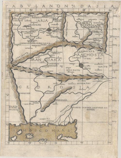
Auction 198, Lot 631
Subject: Pakistan & Afghanistan
Ptolemy/Berlinghieri
Tabula Nona d Asia, 1482
Size: 10.5 x 13.3 inches (26.7 x 33.8 cm)
Estimate: $1,900 - $2,200
One of the Earliest Printed Maps of Afghanistan & Pakistan
Sold for: $2,500
Closed on 6/19/2024
Auction 197, Lot 641
Subject: China
Ortelius, Abraham
Chinae, olim Sinarum Regionis, Nova Descriptio. Auctore Ludovico Georgio, 1584
Size: 18.4 x 14.5 inches (46.7 x 36.8 cm)
Estimate: $4,000 - $4,750
The First European-Printed Map of China
Sold for: $3,000
Closed on 4/24/2024
Auction 197, Lot 658
Subject: East Indies - Indonesia, Singapore, & Macao
Bry, Johann Theodore de
[Petits Voyages, Part VIII] Indiae Orientalis Pars Octava: Navigationes Quinque, Primam a Iacobo Neccio, ab Anno 1600..., 1607
Size: 8.4 x 12.3 inches (21.3 x 31.2 cm)
Estimate: $3,750 - $4,500
Complete Disbound Example of Petits Voyages, Part VIII, with Map of Strait of Singapore and Plan of Macao
Sold for: $5,500
Closed on 4/24/2024
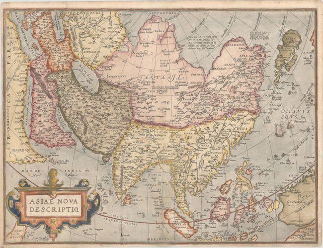
Auction 196, Lot 605
Subject: Asia
Ortelius, Abraham
Asiae Nova Descriptio, 1572
Size: 19.8 x 14.8 inches (50.3 x 37.6 cm)
Estimate: $1,200 - $1,500
Rare First Plate of Ortelius' Important Map of Asia
Sold for: $900
Closed on 2/7/2024
Auction 196, Lot 607
Subject: Asia
Wit, Frederick de
Asiae Nova Descriptio, 1670
Size: 21.9 x 17.4 inches (55.6 x 44.2 cm)
Estimate: $2,200 - $2,500
De Wit's Carte-a-Figures Map of Asia
Sold for: $2,300
Closed on 2/7/2024
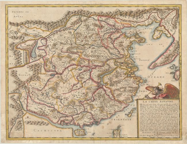
Auction 196, Lot 626
Subject: China & Korea
Sanson/Mariette
La Chine Royaume..., 1656
Size: 21.1 x 16.3 inches (53.6 x 41.4 cm)
Estimate: $1,200 - $1,500
Important Jesuit Map of China
Unsold
Closed on 2/7/2024
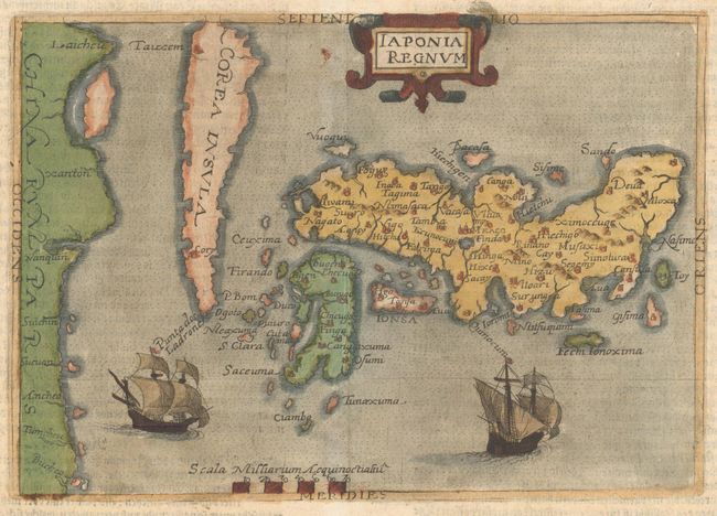
Auction 196, Lot 630
Subject: Japan & Korea
Botero, Giovanni
Iaponia Regnum, 1596
Size: 8.3 x 5.8 inches (21.1 x 14.7 cm)
Estimate: $2,000 - $2,400
Rare First Derivative of Ortelius/Teixeira Map of Japan
Sold for: $1,000
Closed on 2/7/2024
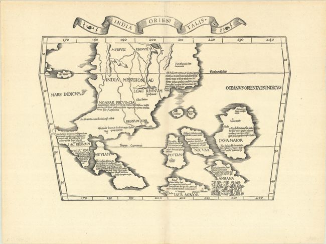
Auction 196, Lot 634
Subject: Southeast Asia
Ptolemy/Fries
India Orientalis, 1535
Size: 17 x 12.3 inches (43.2 x 31.2 cm)
Estimate: $2,750 - $3,500
First Printed Map to Focus on Indochina and the East Indies
Unsold
Closed on 2/7/2024
1029 lots
Page 1 of 21