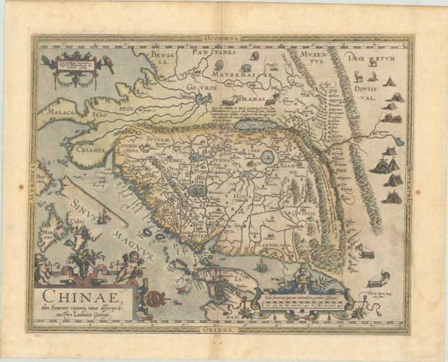
Subject: China
Period: 1584 (dated)
Publication: Theatrum Orbis Terrarum
Color: Hand Color
Size:
18.4 x 14.5 inches
46.7 x 36.8 cm
This landmark map provides a fascinating view of the mysterious orient from a Renaissance perspective. Ortelius based the map on the work of Jorge de Barbuda, a Portuguese Jesuit also known as Ludovicus Georgius, whose manuscript map reached Ortelius by way of Arias Montanus. The depiction, which became the standard image of China for over half a century, shows the legendary kingdom at an early point in European exploration of the region. The map is oriented with north to the right and extends into parts of Indo-China, the Philippines and part of Japan. The Great Wall is prominently delineated and several huge lakes and rivers dominate the topography. Illustrations in the interior include tent cities of the Tartars, stags, elephants and elaborate sail-powered carriages. The map is further adorned with three ornamental cartouches. This is the first state, published in the Latin edition of 1584 with no page number on verso.
References: Walter #11F; Van den Broecke #164.
Condition: B+
A dark impression on a sturdy sheet with the crossed arrows watermark commonly found on Ortelius maps. There is a faint dampstain in the bottom third of the image, marginal foxing and soiling, and some small pieces of tape along the edges of the sheet on verso.