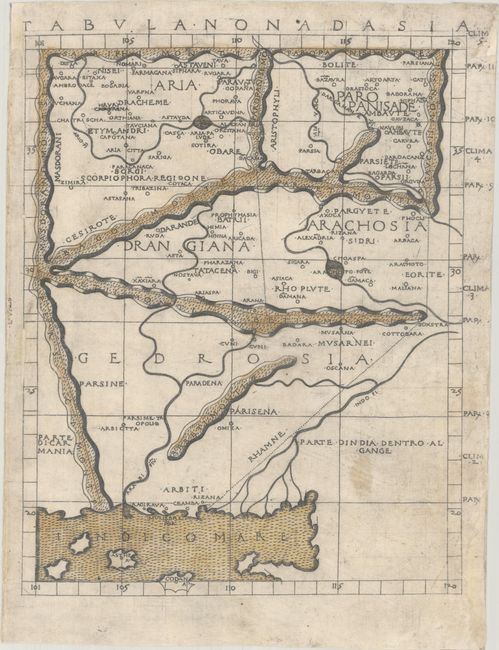
Subject: Pakistan & Afghanistan
Period: 1482 (circa)
Publication: Geographia
Color: Hand Color
Size:
10.5 x 13.3 inches
26.7 x 33.8 cm
Claudius Ptolemy was a mathematician, astronomer and geographer who worked in Alexandria, then a part of the Roman Empire, in the 2nd century AD. One of the most learned and influential men of his time, his theories dominated both astronomy and geography for nearly 1500 years. His writings were kept alive by Arabic scholars during the Middle Ages and reemerged in Europe during the Renaissance. The birth of printing led to wide dissemination of his great works on astronomy and geography. There were a number of editions of his Geographia beginning in 1477. These early editions contained maps based on his original writings, known as Ptolemaic maps. As geographic knowledge increased with the explorations of Columbus, Magellan, Cabot and others, maps of the New World were added, and maps of the Old World were revised. Ptolemy's Geographia continued to be revised and published by some of the most important cartographers including Martin Waldseemuller, Sebastian Munster, Giacomo Gastaldi, Jodocus Hondius, and Gerard Mercator (whose last edition was published in 1730).
This extremely rare map of present-day Afghanistan and Pakistan is likely the earliest obtainable map of the region. The map appeared in an edition of Berlinghieri's Ptolemaic atlas, one of the first with maps engraved on copper. They were also the only maps drawn on the original projection, with equidistant meridians and parallels. Francesco di Nicola Berlinghieri paraphrased Ptolemy in Italian terza rima (a poetic form ), making this from the first atlas in vernacular Italian. The map is beautifully engraved with stippled seas and a unique depiction of the mountain ranges.
References: Mickwitz & Miekkavaara #198:26; Imago Mundi, Vol. 56, No. 2, pp. 152-169.
Condition: B
A crisp impression with archival repairs to some chips along the edges of the sheet and a few worm tracks along the left neatline, with a bit of loss of the neatline at left. The map is backed with Japanese tissue.