Subject: World
Period: 1897 (circa)
Publication:
Color: Printed Color
Size:
42 x 35.3 inches
106.7 x 89.7 cm
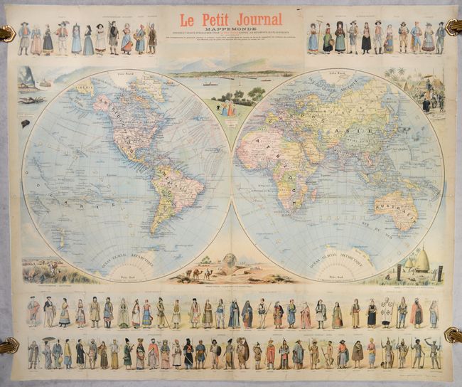
This spectacular double-hemisphere world map was published as a supplement to Le Petit Journal, the major Parisian daily newspaper published from 1863 to 1944. It was designed and drawn by F. Menetrier and engraved and printed by E. Charaire. The map shows national boundaries, names of important cities, major railways, and more. Various shipping routes are delineated in the ocean, with the approximate length of the trips noted (for example, New York to Liverpool takes 5-6 days, while London to Australia or New Zealand takes 45 days). Fridtjof Nansen's latest discoveries in the North Pole (1895) are noted, and Antarctica is beginning to take shape. Along the top and bottom of the map are rows of dozens of figures from around the world in all manner of traditional dress, including a Scotsman with bagpipe and kilt, a toreador, a Moroccan chief, a gaucho, an Aboriginal Australian, and much more. Around the hemispheres are vignettes showing scenes from each of the populated continents: a paddle steamer on the St. Lawrence, an idyllic scene at Lake Geneva, figures riding an elephant through a village in Indochina, cattle driving in the Pampas, the Sphinx, and a Kanak village in New Caledonia. A highly decorative pictorial map that reflects the worldview of the French colonial empire at the turn of the century.
References: Rumsey #10477.
Condition: B
Issued folding and now flattened and backed with tissue to reinforce and repair a number of short fold separations with some related small losses at the fold junctions. There is some light staining primarily off the coast of Japan and east of the Lesser Antilles.