Subject: Western England & Wales
Period: 1675 (circa)
Publication: Britannia…
Color: Hand Color
Size:
18.3 x 12.1 inches
46.5 x 30.7 cm
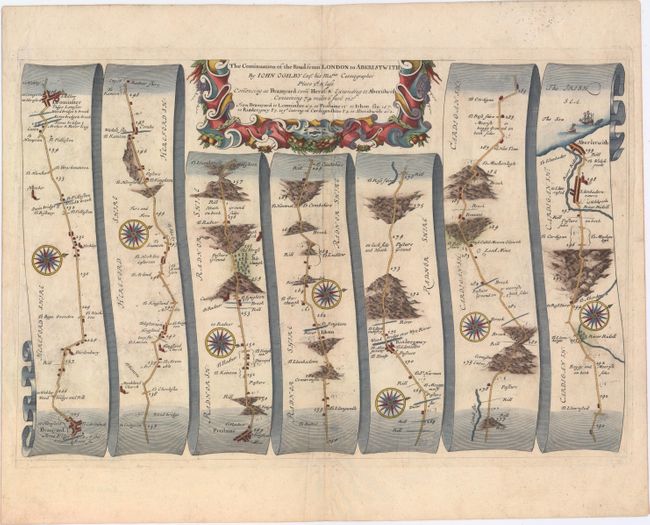
John Ogilby's 'Britannia' was published between 1675 and 1698. It is a landmark in the mapping of England and Wales. Its unique format constituted the first national road-atlas of any country in Western Europe. It was composed of maps of seventy-three major roads and cross-roads, presented in a continuous strip-form, on a uniform scale of one inch to a mile. Each beautiful map includes wonderful detail of the countryside with each strip containing a large compass rose to indicate changes in direction.
This attractive strip-style map covers 74 miles of roads in Herefordshire, England and Wales. It is in the pictorial style pioneered by Ogilby with the road laid out in several ribbon-like panels. Each of the seven panels has a decorative compass rose to orient the traveler. The route travels from Bromyard, Herefordshire and proceeds in a westerly direction to the Welch port of Aberystwyth along Cardigan Bay. Embellished with a strapwork title cartouche featuring carrots, grapes, and other flora.
References: Moorland & Bannister, pp. 157-8; Shirley (BL Atlases) T.OGIL-4a #3.
Condition: B+
A nice impression on watermarked paper with attractive color and light soiling. There are several tiny holes that have been professionally repaired.