Showing Featured Lots(remove filter)
Showing results for:Auction 189
Catalog Archive
62 lots
Page 1 of 2
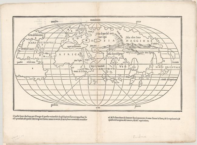
Auction 189, Lot 2
Subject: World
Bordone, Benedetto
[Untitled - World], 1528
Size: 15.1 x 8.6 inches (38.4 x 21.8 cm)
Estimate: $4,000 - $4,750
One of the Earliest World Maps on an Oval Projection
Sold for: $3,500
Closed on 9/14/2022
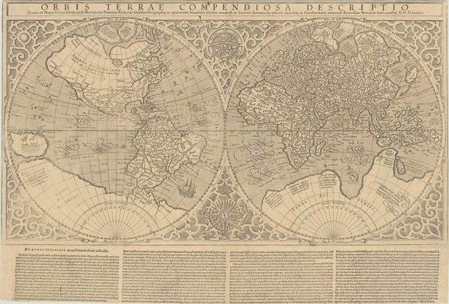
Auction 189, Lot 3
Subject: World
Mercator, Rumold
Orbis Terrae Compendiosa Descriptio quam ex Magna Universali Gerardi Mercatoris..., 1587
Size: 20.8 x 11.4 inches (52.8 x 29 cm)
Estimate: $4,500 - $5,500
Early Example of Mercator's Double-Hemisphere World Map with Text Below Map
Sold for: $3,250
Closed on 9/14/2022
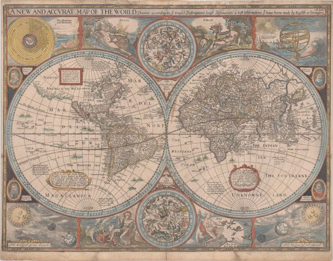
Auction 189, Lot 6
Subject: World
Speed, John
A New and Accurat Map of the World Drawne According to ye Truest Descriptions Latest Discoveries & Best Observations yt Have Beene Made by English or Strangers, 1626
Size: 20.6 x 15.5 inches (52.3 x 39.4 cm)
Estimate: $14,000 - $16,000
First State of Speed's Double-Hemisphere World Map with Rare Blank Verso
Sold for: $11,000
Closed on 9/14/2022
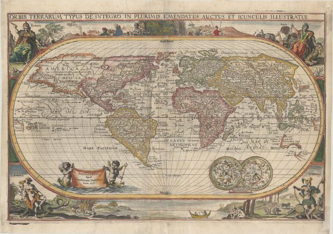
Auction 189, Lot 9
Subject: World
Danckerts, Family
Orbis Terrarum Typus de Integro in Plurimis Emendatus Auctus et Icunculis Illustratus, 1658
Size: 18.4 x 12.1 inches (46.7 x 30.7 cm)
Estimate: $4,000 - $5,000
Unusual and Rare Oval Dutch Bible Map of the World
Sold for: $6,500
Closed on 9/14/2022
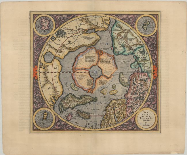
Auction 189, Lot 40
Subject: North Pole
Mercator, Gerard
Septentrionalium Terrarum Descriptio, 1609
Size: 15.4 x 14.4 inches (39.1 x 36.6 cm)
Estimate: $2,750 - $3,500
The First Printed Map Devoted to the Arctic
Sold for: $2,750
Closed on 9/14/2022
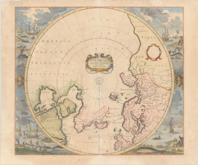
Auction 189, Lot 42
Subject: North Pole
Hondius, Henricus
Poli Arctici, et Circumiacentium Terrarum Descriptio Novissima, 1639
Size: 19.5 x 17 inches (49.5 x 43.2 cm)
Estimate: $1,900 - $2,200
Magnificent Polar Map Surrounded by Whaling Scenes
Sold for: $1,400
Closed on 9/14/2022
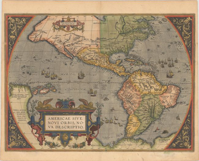
Auction 189, Lot 58
Subject: Western Hemisphere - America
Ortelius, Abraham
Americae sive Novi Orbis, Nova Descriptio, 1587
Size: 19.1 x 14 inches (48.5 x 35.6 cm)
Estimate: $6,000 - $7,500
Ortelius' Influential Map of the New World in Full Contemporary Color
Sold for: $4,500
Closed on 9/14/2022
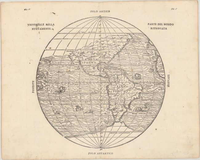
Auction 189, Lot 59
Subject: Western Hemisphere - America
Gastaldi/Ramusio
Universale della Parte del Mondo Nuovamente Ritrovata, 1606
Size: 10.4 x 10.6 inches (26.4 x 26.9 cm)
Estimate: $3,250 - $4,000
First Printed Map to Reflect Coronado's Explorations in the Southwest
Sold for: $2,100
Closed on 9/14/2022
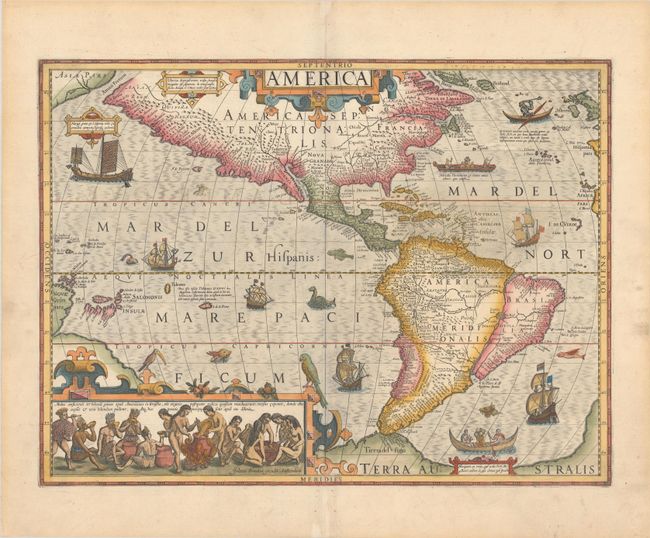
Auction 189, Lot 60
Subject: Western Hemisphere - America
Hondius, Jodocus
America, 1628
Size: 19.6 x 14.7 inches (49.8 x 37.3 cm)
Estimate: $4,750 - $6,000
Hondius' Important Map of the Americas
Sold for: $3,500
Closed on 9/14/2022
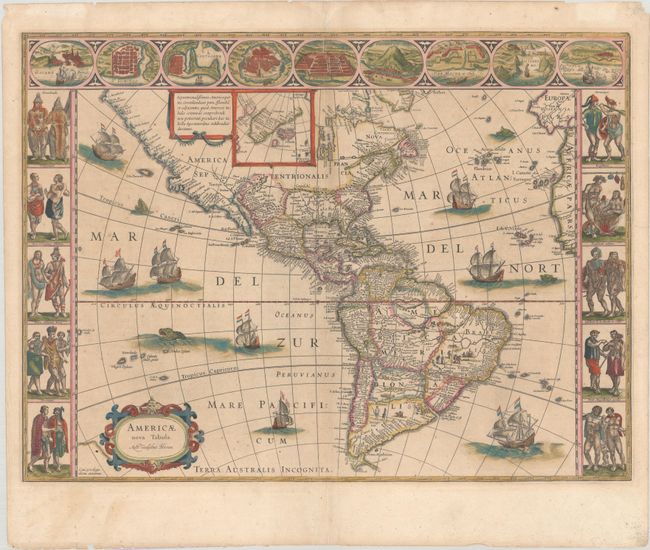
Auction 189, Lot 61
Subject: Western Hemisphere - America
Blaeu, Willem
Americae Nova Tabula, 1643
Size: 22 x 16.3 inches (55.9 x 41.4 cm)
Estimate: $4,750 - $6,000
Blaeu's Stunning Carte-a-Figures Map of the Americas
Sold for: $3,000
Closed on 9/14/2022
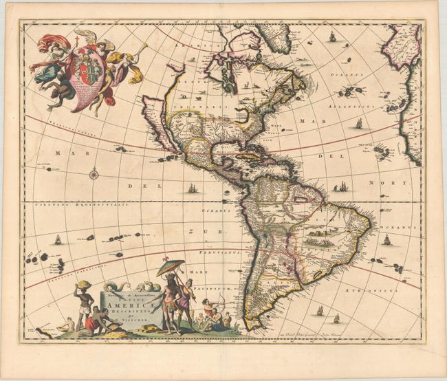
Auction 189, Lot 64
Subject: Western Hemisphere - America
Visscher, Nicolas
Novissima et Accuratissima Totius Americae Descriptio, 1677
Size: 21.6 x 17.2 inches (54.9 x 43.7 cm)
Estimate: $1,900 - $2,200
Visscher's Classic Map of the Americas with the Island of California in Full Contemporary Color
Sold for: $1,400
Closed on 9/14/2022
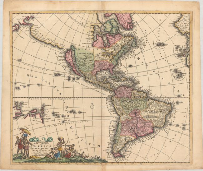
Auction 189, Lot 68
Subject: Western Hemisphere - America
Ottens/De Wit
Recentissima Novi Orbis sive Americae Septentrionalis et Meridionalis Tabula, 1727
Size: 22.6 x 19.3 inches (57.4 x 49 cm)
Estimate: $1,600 - $1,900
Attractive Map of the Americas with Land Bridge to Asia
Sold for: $1,200
Closed on 9/14/2022
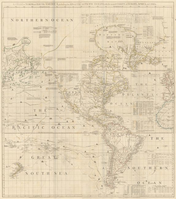
Auction 189, Lot 71
Subject: Western Hemisphere - America
Jefferys/Sayer & Bennett
[On 6 Sheets] A Chart of North and South America, Including the Atlantic and Pacific Oceans, with the Nearest Coasts of Europe, Africa, and Asia, 1775
Size: 44 x 18 inches (111.8 x 45.7 cm)
Estimate: $3,000 - $4,000
One of the Most Important American Maps of the Latter Part of the Eighteenth Century
Sold for: $2,200
Closed on 9/14/2022
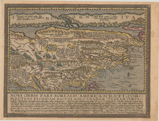
Auction 189, Lot 76
Subject: Colonial North America
Quad, Matthias von Kinckelbach
Novi Orbis Pars Borealis, America Scilicet, Complectens Floridam, Baccalaon, Canadam, Terram Corterialem, Virginiam..., 1600
Size: 11.6 x 9 inches (29.5 x 22.9 cm)
Estimate: $2,750 - $3,500
One of the Earliest Maps Devoted to North America
Sold for: $2,300
Closed on 9/14/2022
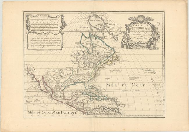
Auction 189, Lot 77
Subject: Colonial North America
Delisle, Guillaume
L'Amerique Septentrionale. Dressee sur les Observations de Mrs. de l'Academie Royale des Sciences. & Quelques Autres, & sur les Memoires les Plus Recens, 1700
Size: 23.8 x 17.9 inches (60.5 x 45.5 cm)
Estimate: $1,900 - $2,200
Delisle's Foundation Map of North America
Sold for: $1,400
Closed on 9/14/2022
Auction 189, Lot 79
Subject: Colonial North America
Senex, John
North America Corrected from the Observations Communicated to the Royal Society at London, and the Royal Academy at Paris, 1710
Size: 25.8 x 37.5 inches (65.5 x 95.3 cm)
Estimate: $3,000 - $3,750
One of the Earliest Large-Scale English Maps of North America
Sold for: $4,000
Closed on 9/14/2022
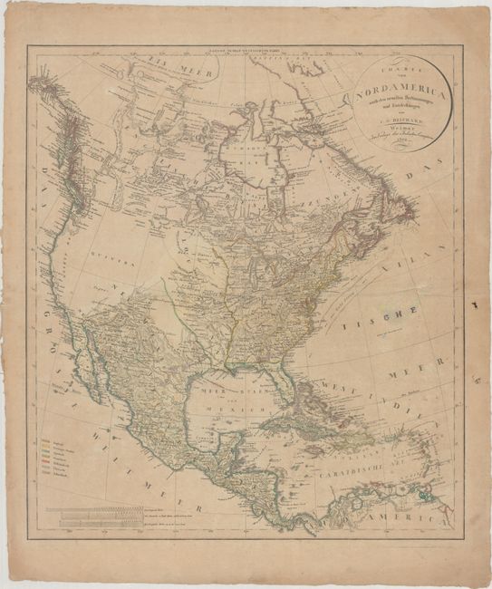
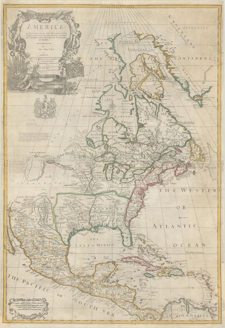
Auction 189, Lot 89
Subject: North America, Franklinia
Reichard, Christian Gottlieb Theoph
Charte von Nordamerica nach den Neuesten Bestimmungen und Entdeckungen..., 1802
Size: 20.6 x 23.2 inches (52.3 x 58.9 cm)
Estimate: $1,100 - $1,400
German Map of North America Featuring the Short-Lived Franklin
Sold for: $800
Closed on 9/14/2022
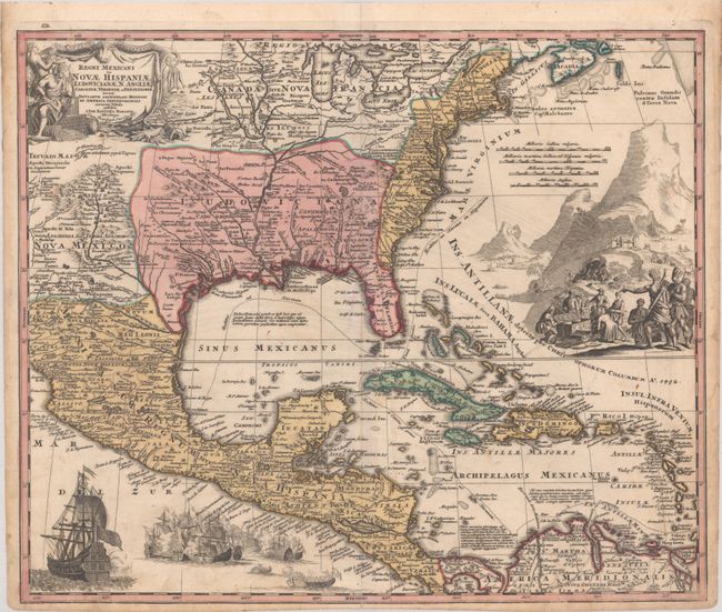
Auction 189, Lot 102
Subject: Colonial Eastern North America & West Indies
Homann, Johann Baptist
Regni Mexicani seu Novae Hispaniae, Ludovicianae, N. Angliae, Carolinae, Virginiae et Pensylvaniae, nec non Insularum Archipelagi Mexicani in America Septentrionali Accurata Tabula, 1720
Size: 22.6 x 18.8 inches (57.4 x 47.8 cm)
Estimate: $1,600 - $1,900
Homann's Decorative Map of Colonial America in the Era of the War of the Spanish Succession
Sold for: $1,700
Closed on 9/14/2022
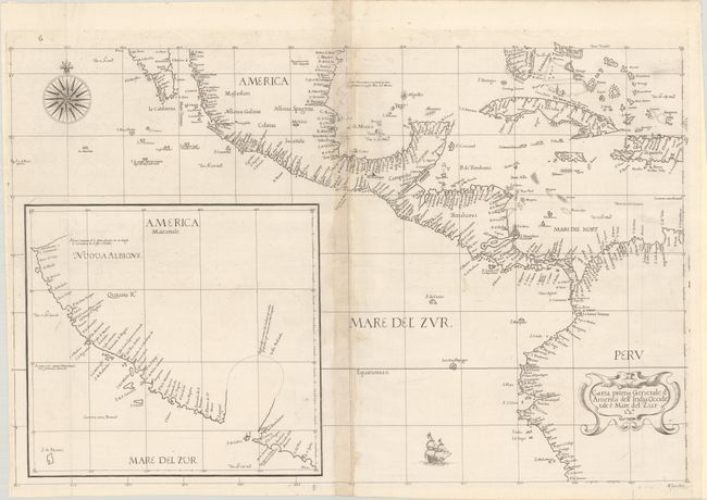
Auction 189, Lot 103
Subject: Western North America & Northern South America
Dudley, Robert (Sir)
Carta Prima Generale d'America dell' India Occidentale e Mare del Zur, 1646
Size: 27.6 x 18.1 inches (70.1 x 46 cm)
Estimate: $4,750 - $6,000
The First Printed Sea Chart of the California Coast
Sold for: $4,250
Closed on 9/14/2022
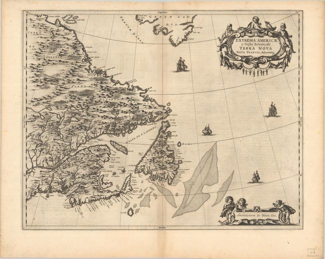
Auction 189, Lot 107
Subject: Eastern Canada
Blaeu, Johannes
Extrema Americae Versus Boream, ubi Terra Nova Nova Francia, Adjacentiaq, 1664
Size: 22.5 x 17.6 inches (57.2 x 44.7 cm)
Estimate: $1,800 - $2,100
Blaeu's Only Map of Canada, Showing the Canadian Maritimes
Sold for: $1,300
Closed on 9/14/2022
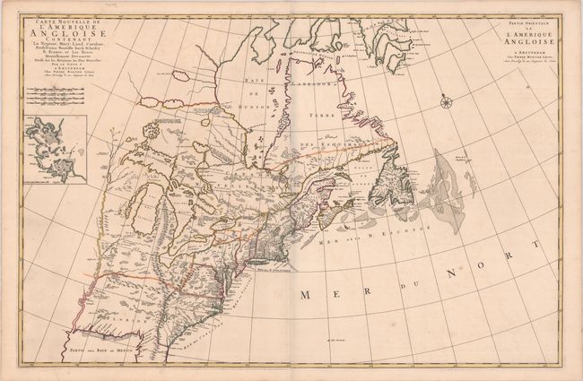
Auction 189, Lot 115
Subject: Colonial Eastern United States & Canada
Mortier, Pierre
Carte Nouvelle de l'Amerique Angloise Contenant la Virginie, Mary-Land, Caroline, Pensylvania Nouvelle Iorck. N: Iarsey N: France, et les Terres Nouvellement Decouerte..., 1700
Size: 35.8 x 23.3 inches (90.9 x 59.2 cm)
Estimate: $2,200 - $2,500
A Map Showing Fascinating Geographic Misconceptions
Sold for: $1,800
Closed on 9/14/2022
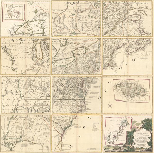
Auction 189, Lot 118
Subject: Colonial Eastern United States & Canada
Zatta, Antonio
[On 12 Sheets] Le Colonie Unite dell' America Settentrle. di Nuova Projezione..., 1778
Size: 16.9 x 12.6 inches (42.9 x 32 cm)
Estimate: $4,750 - $6,000
Impressive 12-Sheet Map of the New "United Colonies"
Sold for: $3,000
Closed on 9/14/2022
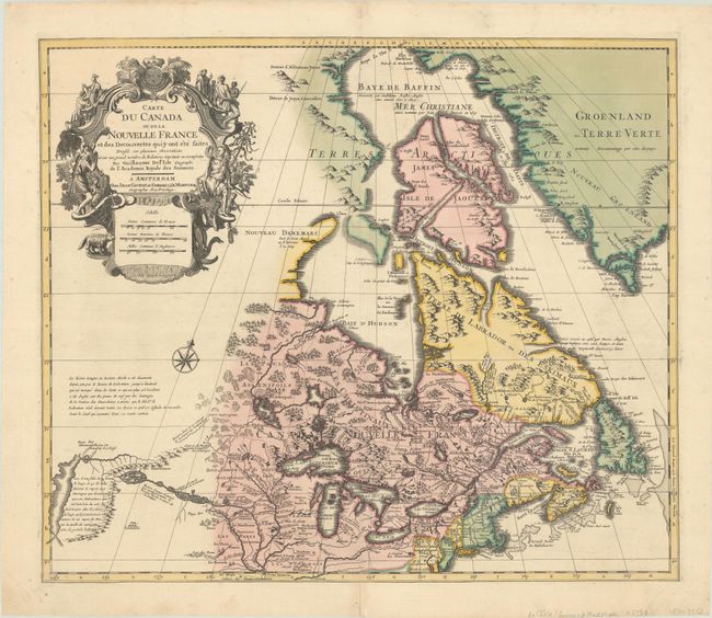
Auction 189, Lot 122
Subject: Colonial Northeastern United States & Canada
Delisle/Covens & Mortier
Carte du Canada ou de la Nouvelle France et des Decouvertes qui y ont ete Faites..., 1730
Size: 22.6 x 19.3 inches (57.4 x 49 cm)
Estimate: $1,400 - $1,700
One of the Most Influential Maps of Canada, Great Lakes & Upper Midwest
Sold for: $900
Closed on 9/14/2022
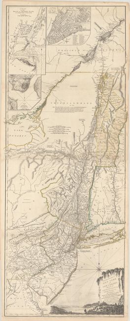
Auction 189, Lot 125
Subject: Colonial Northeastern United States & Quebec
Holland/Pownal
The Provinces of New York and New Jersey; with Part of Pensilvania, and the Province of Quebec, 1776
Size: 21.3 x 52.9 inches (54.1 x 134.4 cm)
Estimate: $3,500 - $4,250
Thomas Jefferys' Important Revolutionary War Period Map
Sold for: $4,000
Closed on 9/14/2022
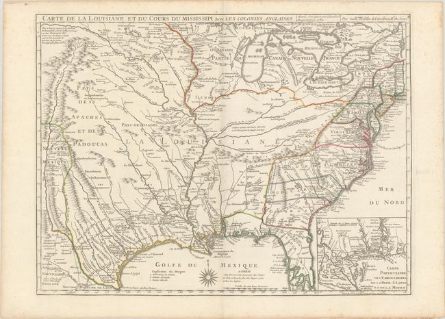
Auction 189, Lot 142
Subject: Colonial Eastern United States, Louisiana Territory
Delisle/Dezauche
Carte de la Louisiane et du Cours du Mississipi avec les Colonies Anglaises, 1782
Size: 25.5 x 19.2 inches (64.8 x 48.8 cm)
Estimate: $1,400 - $1,700
Dezauche Edition of Delisle's Influential Map of the Louisiana Territory
Sold for: $1,000
Closed on 9/14/2022
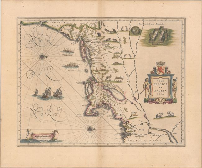
Auction 189, Lot 151
Subject: Colonial New England & Mid-Atlantic United States
Blaeu, Willem
Nova Belgica et Anglia Nova, 1635
Size: 19.9 x 15.3 inches (50.5 x 38.9 cm)
Estimate: $1,900 - $2,200
Important Map of Colonial New England and the Mid-Atlantic in Full Contemporary Color
Sold for: $1,700
Closed on 9/14/2022
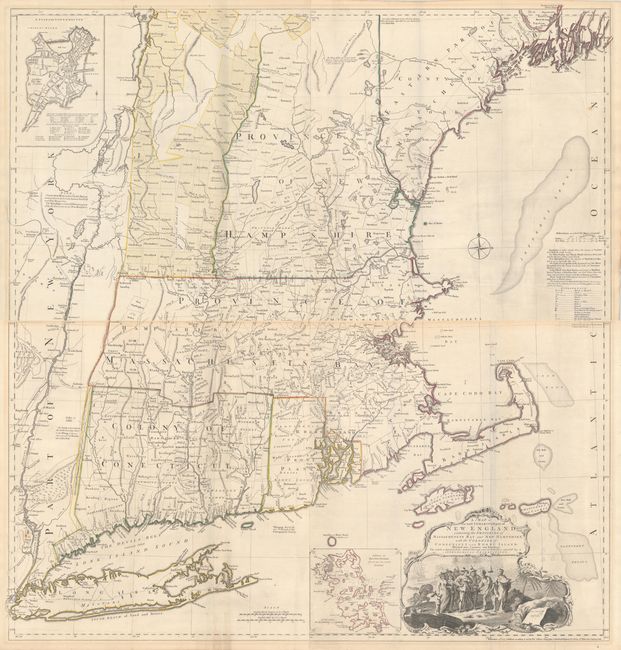
Auction 189, Lot 157
Subject: Colonial New England United States
Jefferys, Thomas
[On 2 Joined Sheets] A Map of the Most Inhabited Part of New England, Containing the Provinces of Massachusets Bay and New Hampshire, with the Colonies of Conecticut and Rhode Island..., 1774
Size: 38.8 x 20.5 inches (98.6 x 52.1 cm)
Estimate: $5,000 - $6,500
Jefferys' Influential Map of New England in Contemporary Outline Color
Sold for: $3,750
Closed on 9/14/2022
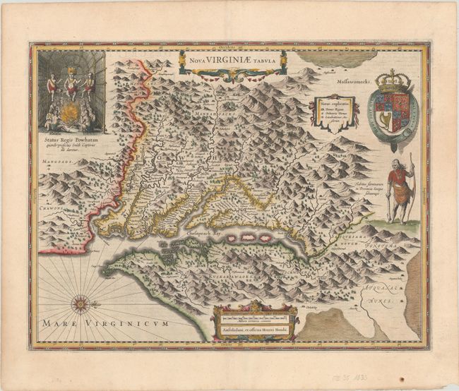
Auction 189, Lot 161
Subject: Colonial Mid-Atlantic United States
Hondius, Henricus
Nova Virginiae Tabula, 1633
Size: 19.6 x 15.1 inches (49.8 x 38.4 cm)
Estimate: $2,000 - $2,300
One of the Most Important 17th Century Maps of the Chesapeake Bay
Sold for: $1,500
Closed on 9/14/2022
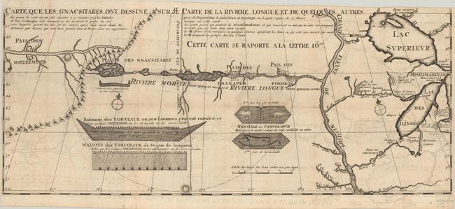
Auction 189, Lot 181
Subject: Colonial Upper Midwestern United States, River Longue
Lahontan, Louis Armand, Baron de
Carte que les Gnacsitares ont Dessine sur ... Carte de la Riviere Longue et de Quelques Autres qui se Dechargent dans le Grand Fleuve Missisipi …, 1703
Size: 26.3 x 11 inches (66.8 x 27.9 cm)
Estimate: $1,600 - $1,900
First Edition of Lahontan's Influential Map Depicting "Riviere Longue"
Sold for: $3,500
Closed on 9/14/2022
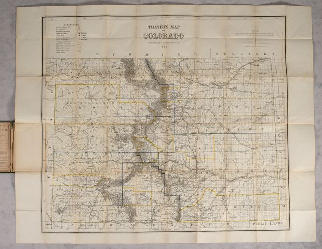
Auction 189, Lot 215
Subject: Colorado
Thayer's Map of Colorado, 1882
Size: 28.2 x 24.5 inches (71.6 x 62.2 cm)
Estimate: $2,500 - $3,250
Final Edition of Thayer's Large Format Map of Colorado
Sold for: $4,250
Closed on 9/14/2022
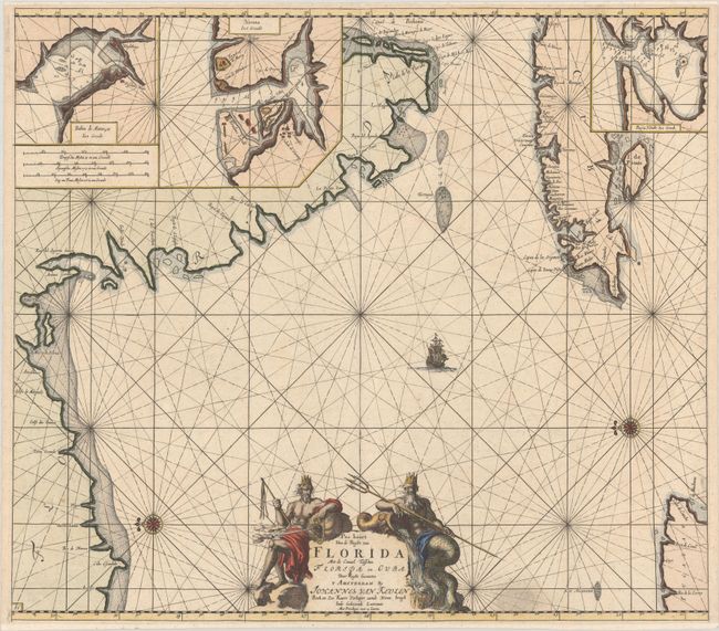
Auction 189, Lot 222
Subject: Florida & Cuba
Keulen/Vooght
Pas Kaart van de Boght van Florida met de Canaal Tusschen Florida en Cuba, 1682
Size: 23 x 20.3 inches (58.4 x 51.6 cm)
Estimate: $3,500 - $4,250
One of the First Charts of the Florida Gulf Coast in Full Contemporary Color
Unsold
Closed on 9/14/2022
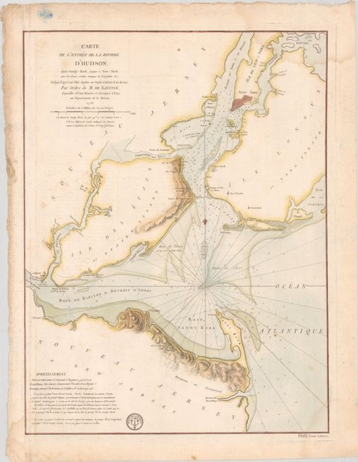
Auction 189, Lot 247
Subject: Colonial New York Harbor, Revolutionary War
Sartine
Carte de l'Entree de la Riviere d'Hudson, Depuis Sandy-Hook Jusques a New-York, avec les Bancs, Sondes, Marques de Navigation &c..., 1778
Size: 17.5 x 23.2 inches (44.5 x 58.9 cm)
Estimate: $1,600 - $1,900
Revolutionary War-Era Chart of New York Harbor Produced by the French Navy
Unsold
Closed on 9/14/2022
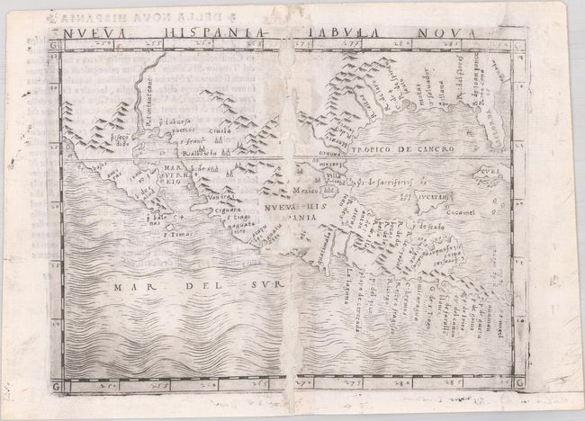
Auction 189, Lot 274
Subject: Southern United States & Mexico
Gastaldi, Giacomo
Nueva Hispania Tabula Nova, 1548
Size: 6.8 x 5 inches (17.3 x 12.7 cm)
Estimate: $2,750 - $3,500
The First Copperplate Map Devoted to North America
Sold for: $1,400
Closed on 9/14/2022
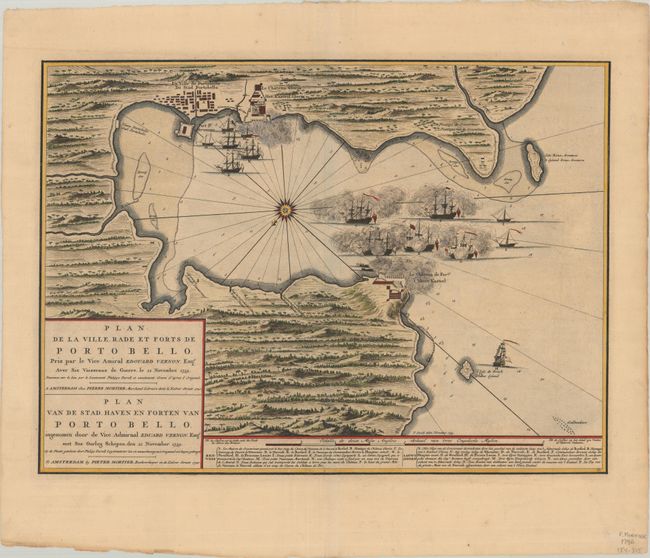
Auction 189, Lot 284
Subject: Portobelo, Panama
Mortier, Pierre
Plan de la Ville Rade et Forts de Porto Bello... / Plan van de Stad Haven en Forten van Porto Bello..., 1740
Size: 22.4 x 16.3 inches (56.9 x 41.4 cm)
Estimate: $1,900 - $2,200
Rare Chart of the Battle of Portobello
Unsold
Closed on 9/14/2022
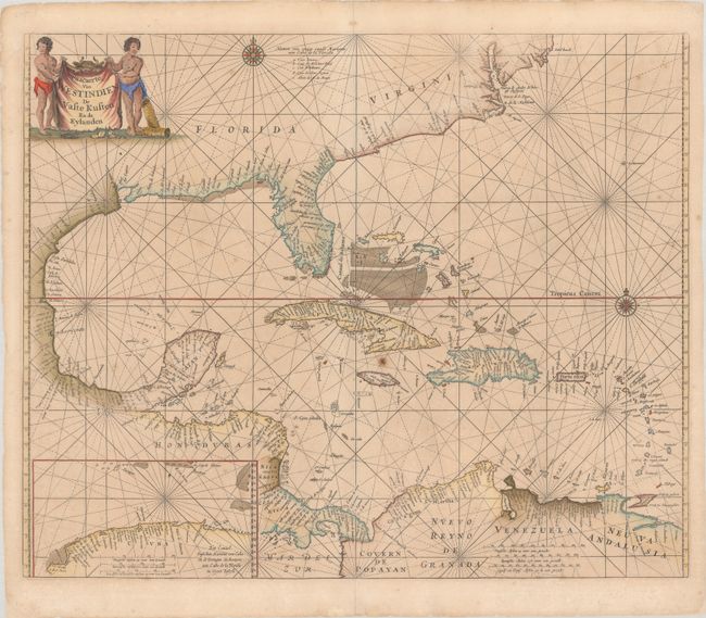
Auction 189, Lot 287
Subject: Gulf of Mexico & Caribbean
Goos, Pieter
Pascaerte van Westindien de Vaste Kusten en de Eylanden, 1666
Size: 21.5 x 17.6 inches (54.6 x 44.7 cm)
Estimate: $2,000 - $2,300
Scarce Sea Chart with Interesting Depiction of the Coastline of the US
Sold for: $1,500
Closed on 9/14/2022
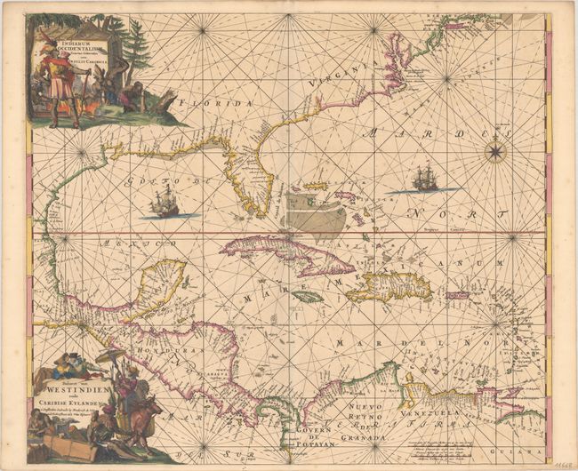
Auction 189, Lot 288
Subject: Gulf of Mexico & Caribbean
Wit, Frederick de
Indiarum Occidentalium Tractus Littorales cum Insulis Caribicis / Pascaert van Westindien ende Caribise Eylanden, 1675
Size: 22.1 x 19.1 inches (56.1 x 48.5 cm)
Estimate: $2,300 - $2,500
A Magnificent Sea Chart of the West Indies in Full Contemporary Color
Sold for: $1,900
Closed on 9/14/2022
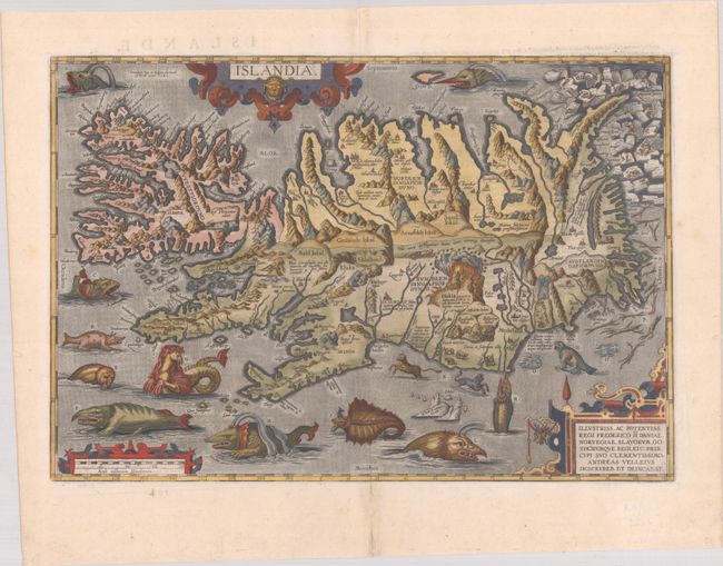
Auction 189, Lot 352
Subject: Iceland
Ortelius, Abraham
Islandia, 1585
Size: 19.5 x 13.3 inches (49.5 x 33.8 cm)
Estimate: $9,000 - $11,000
One of Ortelius' Most Decorative Maps Featuring Fantastical Sea Monsters
Sold for: $10,500
Closed on 9/14/2022
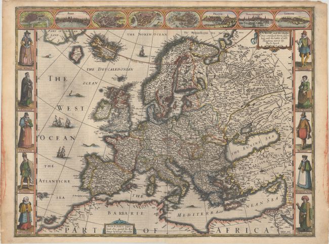
Auction 189, Lot 359
Subject: Europe
Speed, John
Europ, and the Cheife Cities Contayned Therin Described; with the Habits of Most Kingdoms Now in Use, 1626
Size: 20 x 15.4 inches (50.8 x 39.1 cm)
Estimate: $3,000 - $3,750
Speed's Carte-a-Figures Map of Modern Europe
Sold for: $2,200
Closed on 9/14/2022
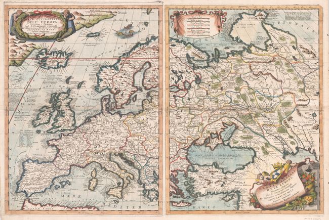
Auction 189, Lot 363
Subject: Europe
Coronelli, Vincenzo Maria
[Lot of 2] Parte Occidentale dell' Europa... [and] Parte Orientale dell' Europa..., 1697
Size: 18.1 x 24.3 inches (46 x 61.7 cm)
Estimate: $2,200 - $2,500
Decorative Two-Sheet Map of Europe
Sold for: $1,600
Closed on 9/14/2022
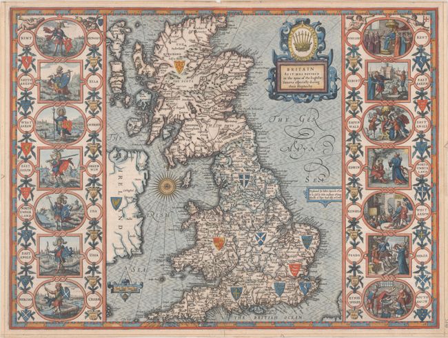
Auction 189, Lot 369
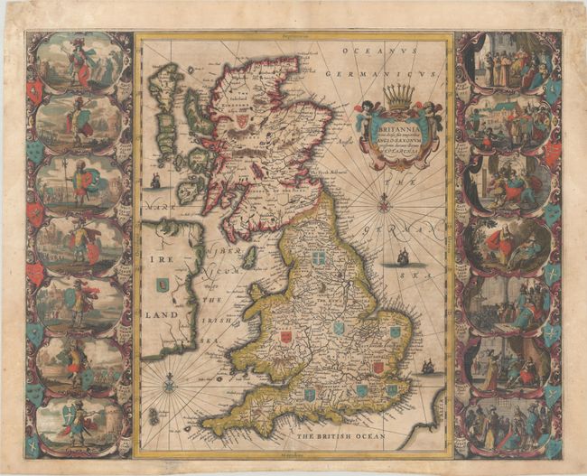
Subject: Britain
Speed, John
Britain as It Was Devided in the Tyme of the Englishe-Saxons Especially During Their Heptarchy, 1616
Size: 20.2 x 15.1 inches (51.3 x 38.4 cm)
Estimate: $3,000 - $3,750
Early Example of Speed's "Heptarchy" Map Depicting the Saxon Kingdoms
Sold for: $3,000
Closed on 9/14/2022
Auction 189, Lot 370
Subject: Britain
Jansson, Jan
Britannia Prout Divisa Suit Temporibus Anglo-Saxonum, Praesertim Durante Illorum Heptarchia, 1646
Size: 20.6 x 16.6 inches (52.3 x 42.2 cm)
Estimate: $1,200 - $1,500
Jansson's Splendid Heptarchy Map in Full Contemporary Color
Unsold
Closed on 9/14/2022
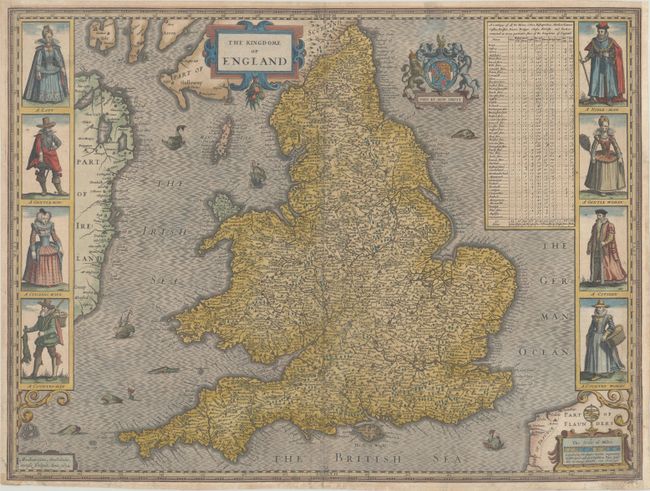
Auction 189, Lot 387
Subject: England & Wales
Speed, John
The Kingdome of England, 1632
Size: 20.3 x 15.2 inches (51.6 x 38.6 cm)
Estimate: $1,500 - $1,800
Speed's Carte-a-Figures Map of England and Wales
Sold for: $1,000
Closed on 9/14/2022
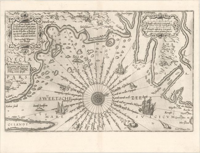
Auction 189, Lot 407
Subject: Southeastern Sweden
Waghenaer, Lucas Jansz
Zee Custe van Sweeden, Otrent de Westerwijck en Tgatt vann Stockholm, Beginnende va Kalmar..., 1585
Size: 20.1 x 12.9 inches (51.1 x 32.8 cm)
Estimate: $1,400 - $1,700
Uncommon and Early Sea Chart of Southeastern Sweden
Sold for: $1,000
Closed on 9/14/2022
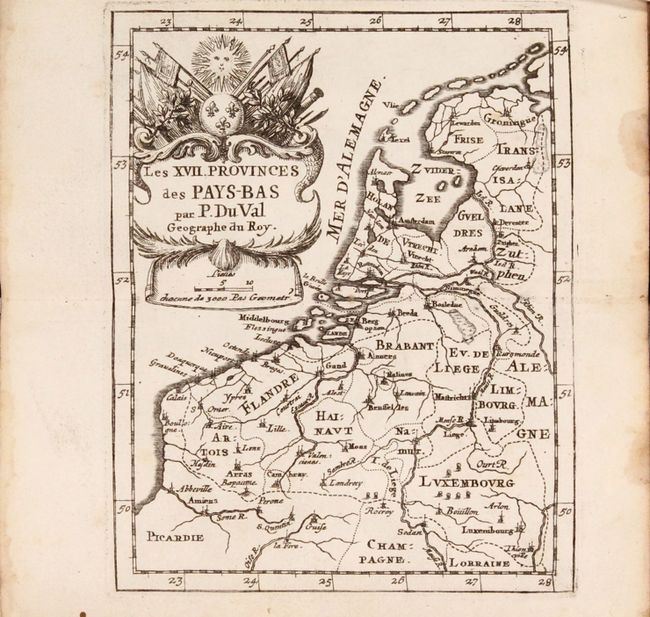
Auction 189, Lot 429
Subject: Low Countries, Atlases
Duval, Pierre
[Two Atlases in One Book] Cartes et Tables de Geographie, des Provinces Eschues a la Reine Tres-Chretiene [and] Les XII. Provinces. Ou sont les Conquestes du Roy en Holande, et en Flandres, 1672
Size: 3.6 x 6 inches (9.1 x 15.2 cm)
Estimate: $1,200 - $1,500
Two Miniature Atlases of Louis XIV's Attempts to Conquer the Spanish Netherlands
Sold for: $900
Closed on 9/14/2022
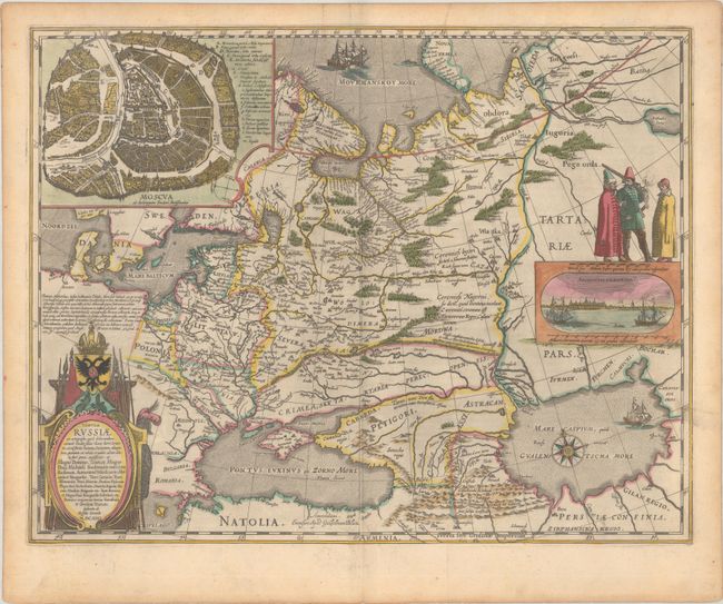
Auction 189, Lot 504
Subject: Russia in Europe
Blaeu, Willem
Tabula Russiae ex Autographo, quod Delineandum Curavit Foedor Filius Tzaris Boris Desumta ... M.DC.XIIII, 1643
Size: 21.4 x 16.7 inches (54.4 x 42.4 cm)
Estimate: $1,800 - $2,100
Blaeu's Decorative Map of Russia
Sold for: $1,300
Closed on 9/14/2022
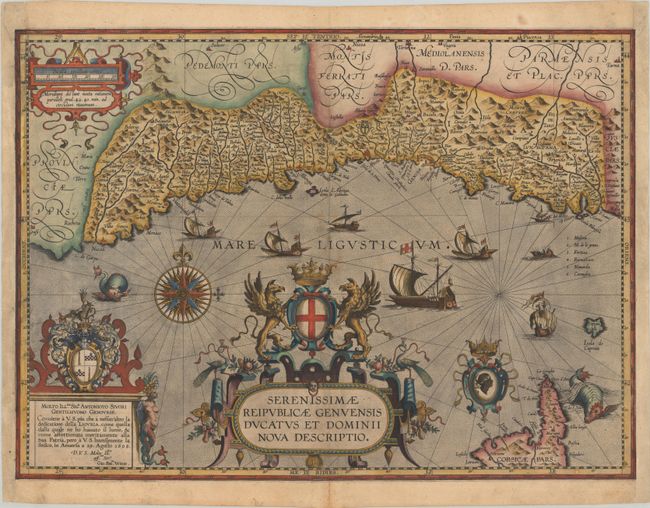
Auction 189, Lot 524
Subject: Northwestern Italy
Ortelius, Abraham
Serenissimae Reipublicae Genuensis Ducatus et Dominii Nova Descriptio, 1608
Size: 21.3 x 15.4 inches (54.1 x 39.1 cm)
Estimate: $4,000 - $4,750
One of the Rarest Maps Published in Ortelius' "Theatrum"
Unsold
Closed on 9/14/2022
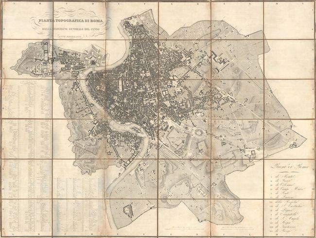
Auction 189, Lot 530
Subject: Rome, Italy
Pianta Topografica di Roma Dalla Direzione Generale del Censo, 1829
Size: 63.1 x 47.1 inches (160.3 x 119.6 cm)
Estimate: $2,000 - $2,300
Rare, Wall-Sized Bird's-Eye Plan of Rome
Sold for: $1,500
Closed on 9/14/2022
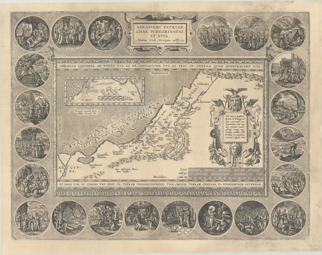
Auction 189, Lot 560
Subject: Holy Land
Ortelius, Abraham
Abrahami Patriarchae Peregrinatio, et Vita, 1586
Size: 18.4 x 14.1 inches (46.7 x 35.8 cm)
Estimate: $1,100 - $1,400
Elaborate Map of the Holy Land, Illustrating the Life of Abraham
Sold for: $700
Closed on 9/14/2022
Auction 189, Lot 566
Subject: Holy Land
Dapper, Olivier
Asia, oder Genaue und Grundliche Beschreibung des Gantzen Syrien und Palestine..., 1688
Size: 8.3 x 13.1 inches (21.1 x 33.3 cm)
Estimate: $3,500 - $4,500
Superb Volume on Syria and Palestine with 39 Maps and Views
Sold for: $2,000
Closed on 9/14/2022
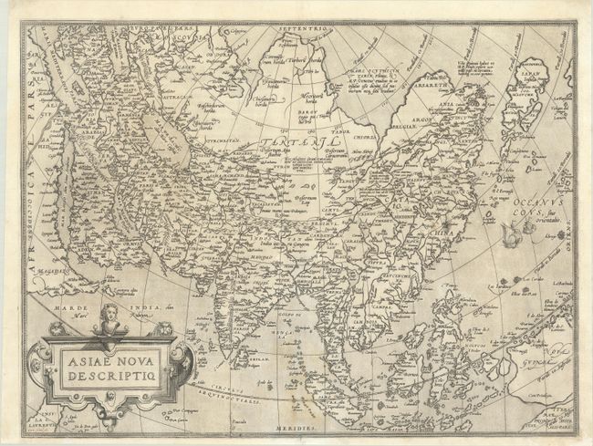
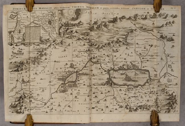
Auction 189, Lot 581
Subject: Asia
Ortelius, Abraham
Asiae Nova Descriptio, 1571
Size: 19.6 x 14.8 inches (49.8 x 37.6 cm)
Estimate: $1,400 - $1,700
Rare First Plate of Ortelius' Important Map of Asia
Sold for: $1,000
Closed on 9/14/2022
62 lots
Page 1 of 2