Showing Featured Lots(remove filter)
Showing results for:Auction 156
Catalog Archive
94 lots
Page 1 of 2
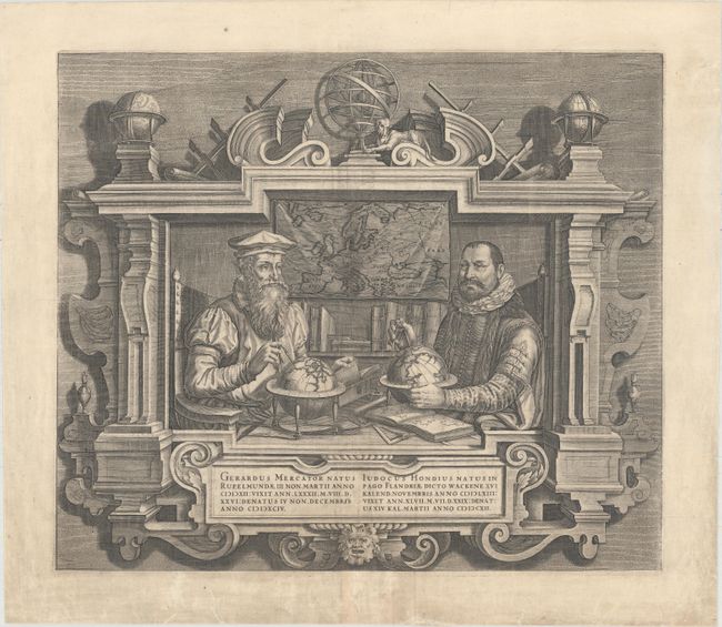
Auction 156, Lot 5
Subject: Title Pages - Portraits
Hondius
Gerardus Mercator ... Iudocus Hondius..., 1613
Size: 17.4 x 15 inches (44.2 x 38.1 cm)
Estimate: $1,600 - $1,900
Famous Portraits of Mercator and Jodocus Hondius
Unsold
Closed on 2/17/2016
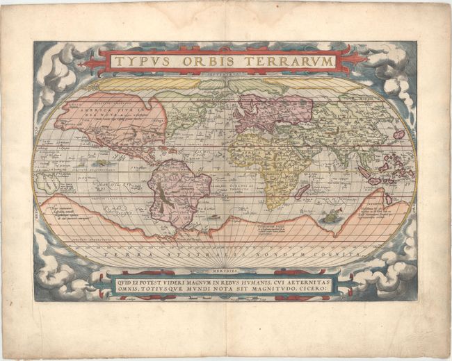
Auction 156, Lot 6
Subject: World
Ortelius, Abraham
Typus Orbis Terrarum, 1571
Size: 19.6 x 13.3 inches (49.8 x 33.8 cm)
Estimate: $7,000 - $8,500
Ortelius' Famous World Map - First Plate
Sold for: $6,000
Closed on 2/17/2016
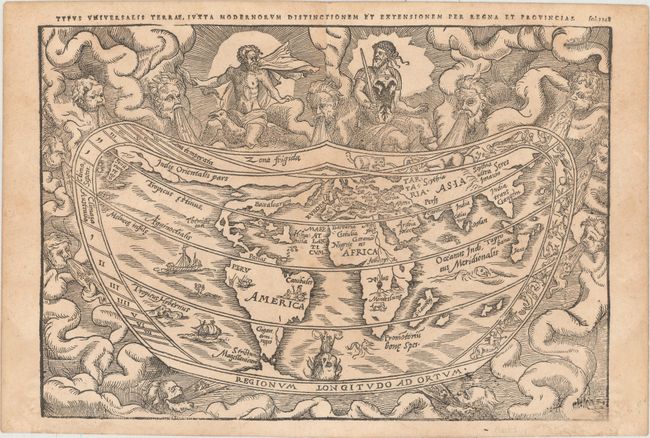
Auction 156, Lot 8
Subject: World
Apianus, Peter Bienewitz
Typus Universalis Terrae, Iuxta Modernorum Distinctionem et Extensionem per Regna et Provincias, 1583
Size: 11 x 7.6 inches (27.9 x 19.3 cm)
Estimate: $4,000 - $5,000
Apianus' Popular Cordiform World Map from the First Woodblock
Unsold
Closed on 2/17/2016
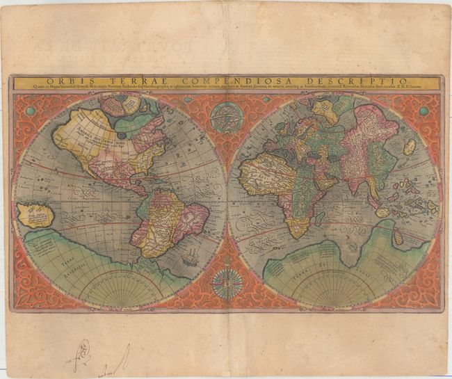
Auction 156, Lot 9
Subject: World
Mercator, Rumold
Orbis Terrae Compendiosa Descriptio quam ex Magna Universali Gerardi Mercatoris Domino Richardo Gartho..., 1587
Size: 20.5 x 11.3 inches (52.1 x 28.7 cm)
Estimate: $4,000 - $4,750
Mercator's Double-Hemisphere World Map in Full Original Color
Sold for: $3,000
Closed on 2/17/2016
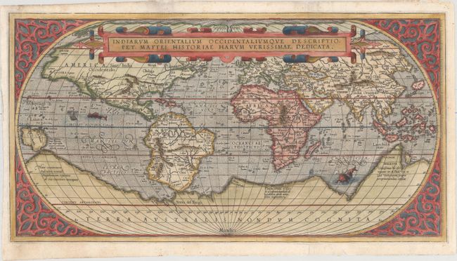
Auction 156, Lot 10
Subject: World
Maffei (Maffeius), Peter
Indiarum Orientalium Occidentaliumque Descriptio..., 1589
Size: 19.2 x 10.2 inches (48.8 x 25.9 cm)
Estimate: $5,000 - $6,500
Scarce Italian World Map Based on Ortelius
Unsold
Closed on 2/17/2016
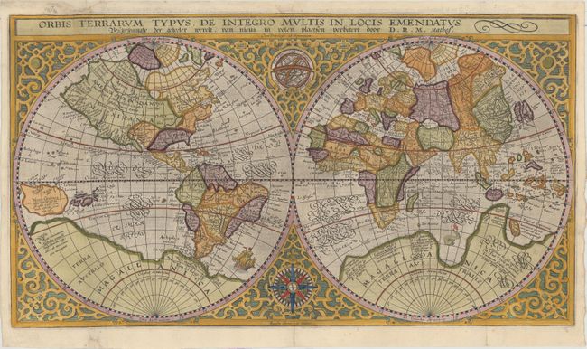
Auction 156, Lot 12
Subject: World
Plancius, Petrus
Orbis Terrarum Typus de Integro Multis in Locis Emendatus..., 1625
Size: 20.3 x 11.3 inches (51.6 x 28.7 cm)
Estimate: $3,250 - $4,000
Plancius' World Map Surrounded by Elegant Strapwork
Sold for: $2,000
Closed on 2/17/2016
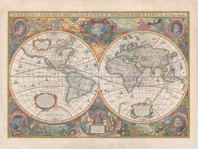
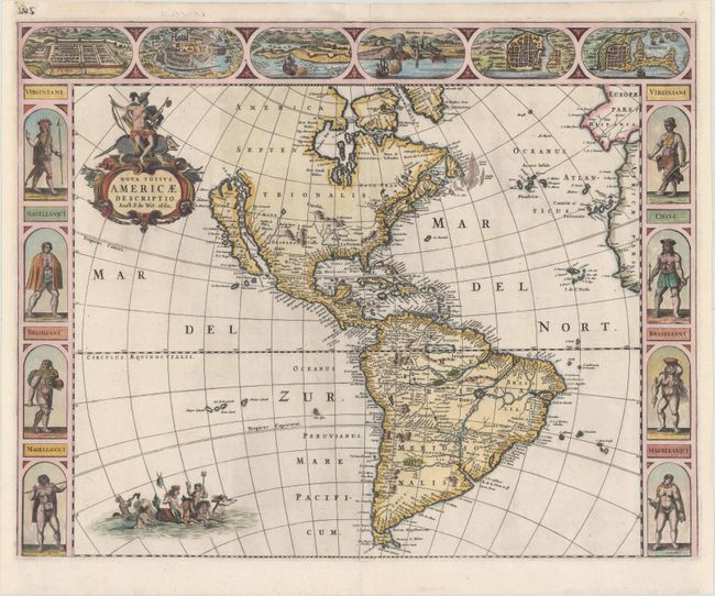
Auction 156, Lot 13
Subject: World
Hondius, Henricus
Nova Totius Terrarum Orbis Geographica ac Hydrographica Tabula, 1630
Size: 21.6 x 15 inches (54.9 x 38.1 cm)
Estimate: $10,000 - $12,000
Henricus Hondius' Baroque-Style World Map
Unsold
Closed on 2/17/2016
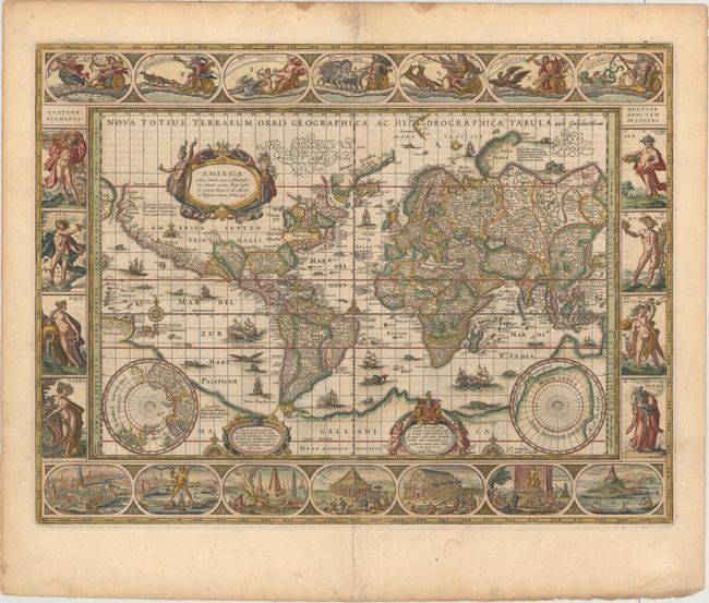
Auction 156, Lot 14
Subject: World
Blaeu, Willem
Nova Totius Terrarum Orbis Geographica ac Hydrographica Tabula, 1635
Size: 21.4 x 16.1 inches (54.4 x 40.9 cm)
Estimate: $14,000 - $16,000
Blaeu's Magnificent Carte-a-Figures World Map
Unsold
Closed on 2/17/2016
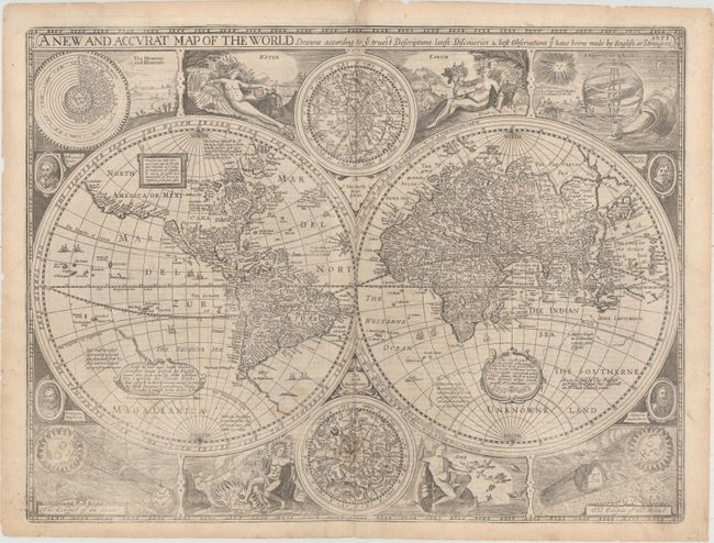
Auction 156, Lot 15
Subject: World
Speed, John
A New and Accurat Map of the World Drawne According to ye Truest Descriptions Latest Discoveries & Best Observations yt Have Beene Made by English or Strangers, 1651
Size: 20.6 x 15.6 inches (52.3 x 39.6 cm)
Estimate: $11,000 - $14,000
Speed's Double-Hemisphere World Map
Sold for: $8,000
Closed on 2/17/2016
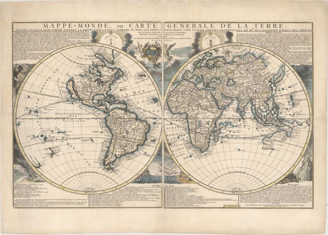
Auction 156, Lot 17
Subject: World
Fer, Nicolas de
Mappe-Monde, ou Carte Generale de la Terre, Divisee en Deux Hemispheres..., 1700
Size: 27.7 x 17.3 inches (70.4 x 43.9 cm)
Estimate: $3,500 - $4,500
Rare First State of De Fer Two-Sheet Map of the World
Sold for: $2,500
Closed on 2/17/2016
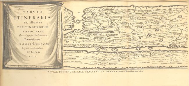
Auction 156, Lot 37
Subject: Ancient World
Jansson, Jan
Tabula Itineraria ex Illustri Peutingerorum Bibliotheca… [in book] Histoire des Grands Chemins de l'Empire Romain, Contenant l'Origine, Progres & Etendue Quasi Incroyable des Chemins Militaires…, 1736
Size: 8.2 x 10.2 inches (20.8 x 25.9 cm)
Estimate: $3,000 - $3,750
Famous Peutinger Table in History of Roman Roads
Unsold
Closed on 2/17/2016
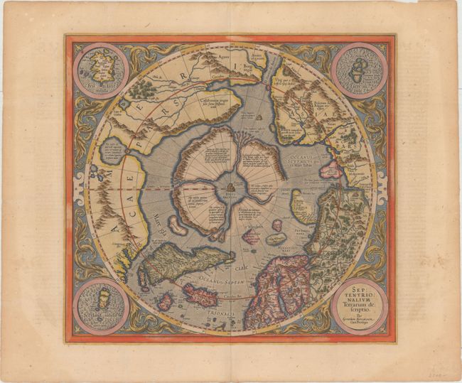
Auction 156, Lot 40
Subject: North Pole
Mercator/Hondius
Septentrionalium Terrarum Descriptio, 1623
Size: 15.5 x 14.5 inches (39.4 x 36.8 cm)
Estimate: $2,000 - $2,300
The First Printed Map Devoted to the Arctic
Sold for: $1,800
Closed on 2/17/2016
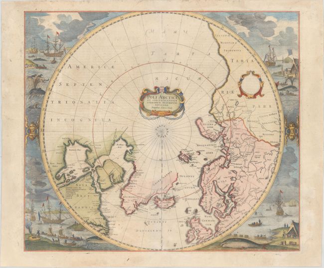
Auction 156, Lot 41
Subject: North Pole
Hondius, Henricus
Poli Arctici, et Circumiacentium Terrarum Descriptio Novissima, 1639
Size: 19.4 x 17 inches (49.3 x 43.2 cm)
Estimate: $2,200 - $2,500
Magnificent Polar Map Surrounded by Whaling Scenes
Unsold
Closed on 2/17/2016
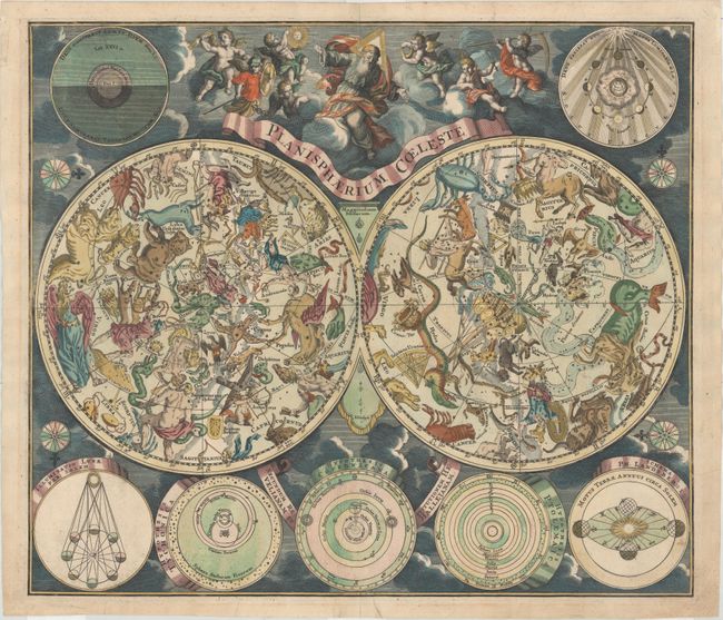
Auction 156, Lot 46
Subject: Celestial
Seutter, Matthias
Planisphaerium Coeleste Secundum Restitutionem Hevelianam et Hallejanam, 1745
Size: 22.3 x 19.4 inches (56.6 x 49.3 cm)
Estimate: $1,600 - $1,900
Seutter's Striking Celestial Chart
Sold for: $1,200
Closed on 2/17/2016
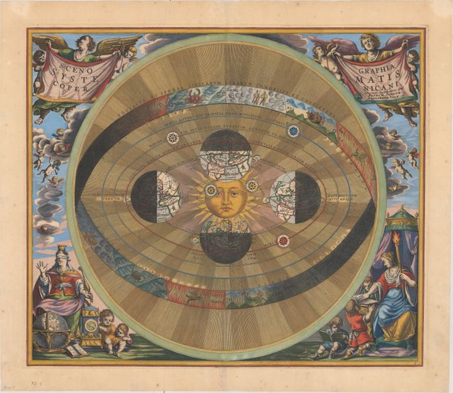
Auction 156, Lot 47
Subject: Solar System
Cellarius/Schenk & Valck
Scenographia Systematis Copernicani, 1708
Size: 19.8 x 16.8 inches (50.3 x 42.7 cm)
Estimate: $2,400 - $3,000
Cellarius' Striking Chart of the Copernican Cosmography
Sold for: $3,750
Closed on 2/17/2016
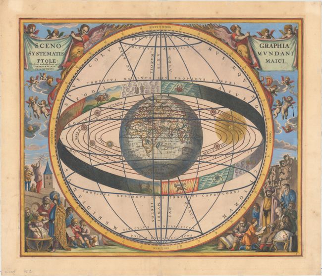
Auction 156, Lot 48
Subject: Solar System
Cellarius/Schenk & Valck
Scenographia Systematis Mundani Ptolemaici, 1708
Size: 19.7 x 16.8 inches (50 x 42.7 cm)
Estimate: $2,400 - $3,000
Cellarius' Striking Chart of the Ptolemaic Cosmography
Sold for: $1,800
Closed on 2/17/2016
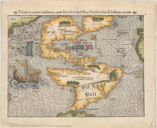
Auction 156, Lot 60
Subject: Western Hemisphere - America
Munster, Sebastian
Tabula Novarum Insularum, quas Diversis Respectibus Occidentales & Indianas Vocant, 1559
Size: 13.5 x 10.1 inches (34.3 x 25.7 cm)
Estimate: $5,500 - $7,000
One of the Most Important 16th Century Maps of the New World
Sold for: $7,000
Closed on 2/17/2016
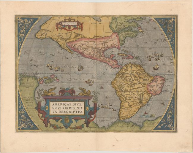
Auction 156, Lot 61
Subject: Western Hemisphere - America
Ortelius, Abraham
Americae sive Novi Orbis, Nova Descriptio, 1587
Size: 18.9 x 13.8 inches (48 x 35.1 cm)
Estimate: $6,000 - $7,500
Ortelius' Influential Map of the New World
Unsold
Closed on 2/17/2016
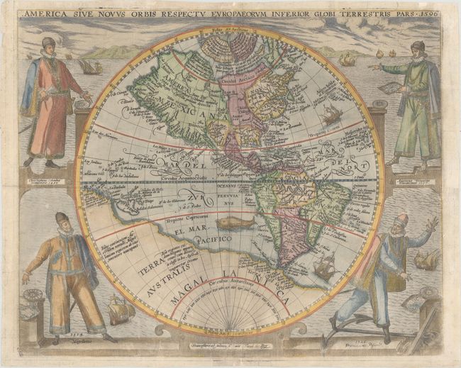
Auction 156, Lot 62
Subject: Western Hemisphere - America
Bry, Theodore de
America sive Novus Orbis Respectu Europaeorum Inferior Globi Terrestris Pars, 1596
Size: 15.6 x 12.9 inches (39.6 x 32.8 cm)
Estimate: $8,000 - $9,000
De Bry's Rare Map of the New World Featuring Explorers
Unsold
Closed on 2/17/2016
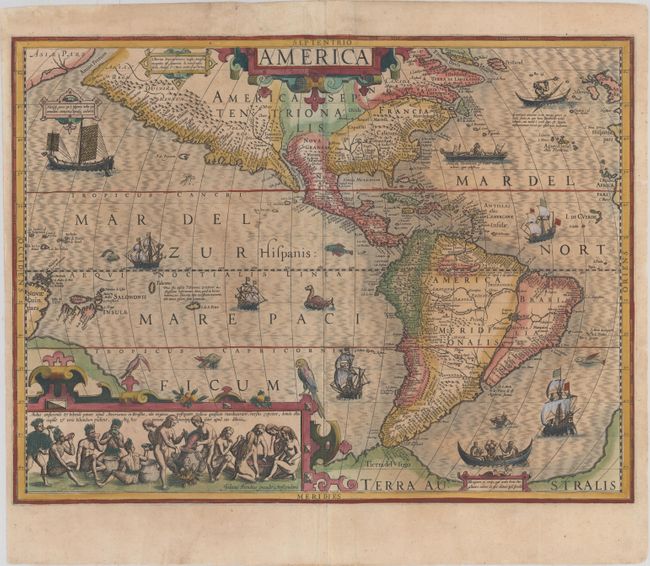
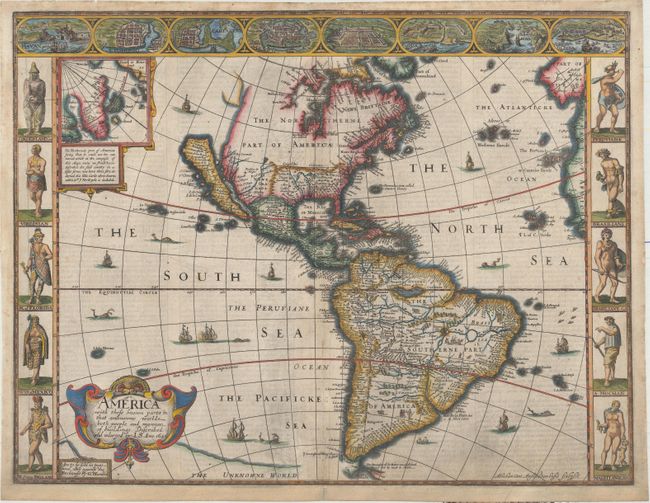
Auction 156, Lot 63
Subject: Western Hemisphere - America
Hondius, Jodocus
America, 1609
Size: 19.7 x 14.8 inches (50 x 37.6 cm)
Estimate: $4,000 - $4,750
Hondius' Important Map of the Americas
Sold for: $2,500
Closed on 2/17/2016
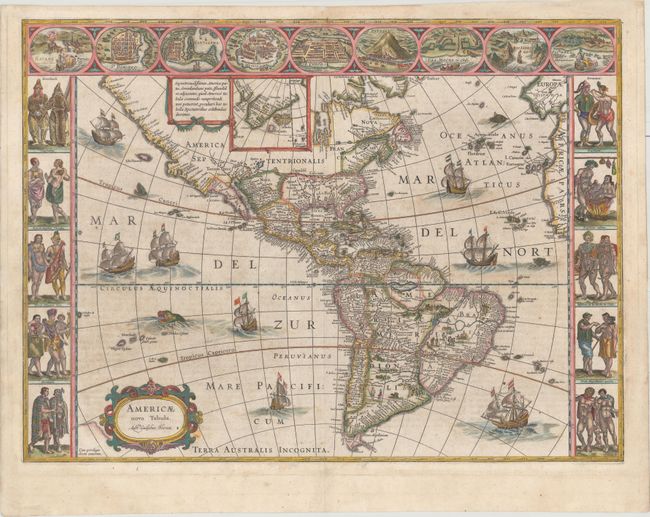
Auction 156, Lot 64
Subject: Western Hemisphere - America
Speed, John
America with Those Known Parts in That Unknowne Worlde Both People and Manner of Buildings Discribed and Inlarged, 1626
Size: 20.1 x 15.4 inches (51.1 x 39.1 cm)
Estimate: $5,500 - $7,000
Speed's Popular Carte-a-Figures Map of the Americas
Sold for: $4,750
Closed on 2/17/2016
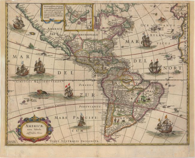
Auction 156, Lot 67
Subject: Western Hemisphere - America
Blaeu, Willem
Americae Nova Tabula, 1633
Size: 18.3 x 14.2 inches (46.5 x 36.1 cm)
Estimate: $2,000 - $2,400
Rare Edition of Blaeu's Map of the Americas
Unsold
Closed on 2/17/2016
Auction 156, Lot 68
Subject: Western Hemisphere - America
Bertius, Petrus
Carte de l'Amerique Corrigee, et Augmentee, Dessus Toutes les Aultres cy Devant Faictes Lannee 1640, 1640
Size: 19.8 x 15.1 inches (50.3 x 38.4 cm)
Estimate: $1,900 - $2,200
Scarce Derivative of Hondius' Map of 1618
Sold for: $1,300
Closed on 2/17/2016
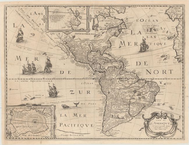
Auction 156, Lot 69
Subject: Western Hemisphere - America
Blaeu, Willem
Americae Nova Tabula, 1643
Size: 21.9 x 16.3 inches (55.6 x 41.4 cm)
Estimate: $6,000 - $7,000
Blaeu's Stunning Carte-a-Figures Map of the Americas
Sold for: $4,000
Closed on 2/17/2016
Auction 156, Lot 70
Subject: Western Hemisphere - America
Wit, Frederick de
Nova Totius Americae Descriptio, 1660
Size: 22 x 17.4 inches (55.9 x 44.2 cm)
Estimate: $4,500 - $5,500
De Wit's Uncommon Carte-a-Figures Map of the Americas
Sold for: $3,250
Closed on 2/17/2016
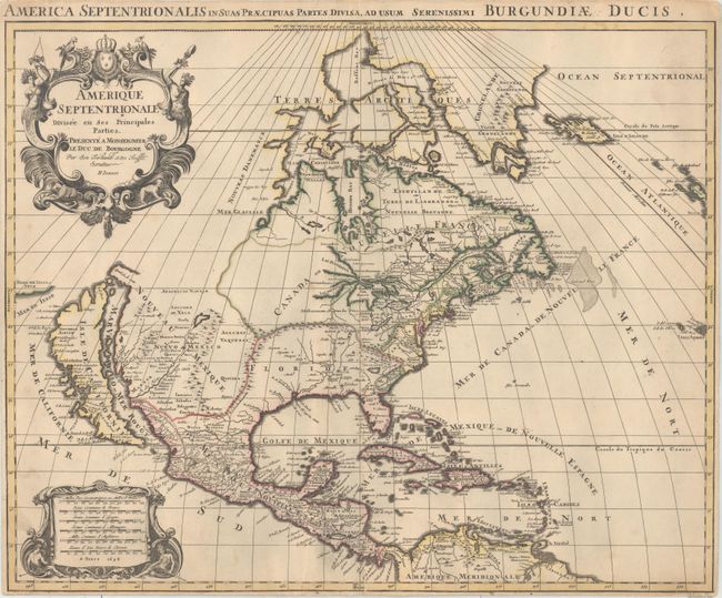
Auction 156, Lot 81
Subject: North America
Sanson/Jaillot
Amerique Septentrionale Divisee en ses Principales Parties, 1694
Size: 22.9 x 18.4 inches (58.2 x 46.7 cm)
Estimate: $2,400 - $3,000
Rare First State with California as an Island
Sold for: $2,200
Closed on 2/17/2016
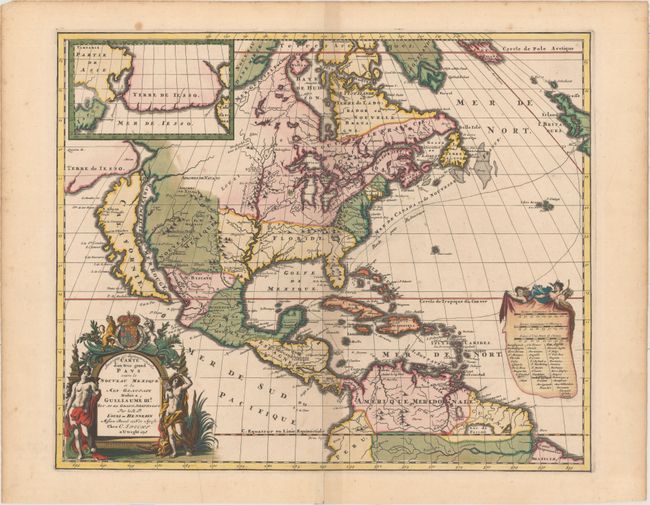
Auction 156, Lot 82
Subject: North America
Hennepin, Louis de (Fr.)
Amerique Septentrionalis Carte d'un Tres Grand Pays Entre le Nouveau Mexique et la Mer Glaciale..., 1698
Size: 20.7 x 17 inches (52.6 x 43.2 cm)
Estimate: $3,250 - $4,000
Hennepin's Influential Map of North America
Sold for: $2,400
Closed on 2/17/2016
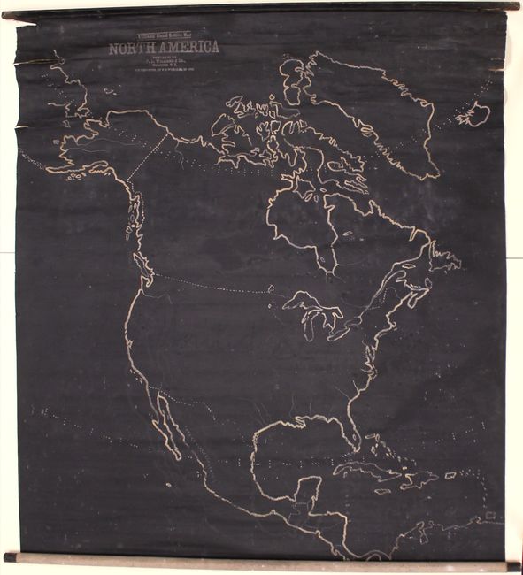
Auction 156, Lot 99
Subject: North America
Williams' Slated Outline Map North America, 1899
Size: 43.4 x 47.9 inches (110.2 x 121.7 cm)
Estimate: $300 - $500
Highly Unusual "Slate" Wall Map
Sold for: $180
Closed on 2/17/2016
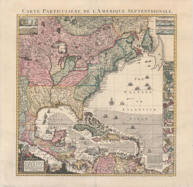
Auction 156, Lot 102
Subject: Colonial Eastern North America & West Indies
Popple/Covens & Mortier
A Map of the British Empire in America with the French, Spanish and the Dutch Settlements Adjacent Thereto, 1741
Size: 18.9 x 19.3 inches (48 x 49 cm)
Estimate: $3,000 - $3,750
Index Sheet of Popple's Map
Unsold
Closed on 2/17/2016
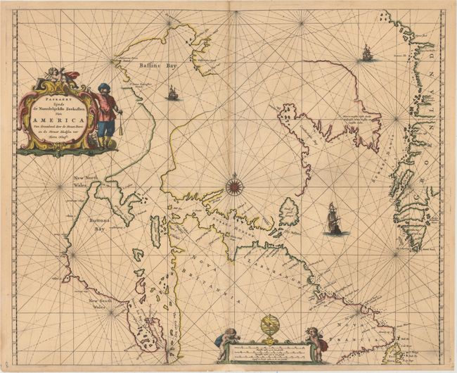
Auction 156, Lot 108
Subject: Eastern Canada and Greenland
Goos, Pieter
Paskaert Zynde de Noordelijckste Zeekusten van America van Groenland door de Straet Davis en de Straet Hudson tot Terra Neuf, 1666
Size: 21.4 x 17.5 inches (54.4 x 44.5 cm)
Estimate: $950 - $1,200
Goos' Uncommon Sea Chart Centered on Hudson Strait
Unsold
Closed on 2/17/2016
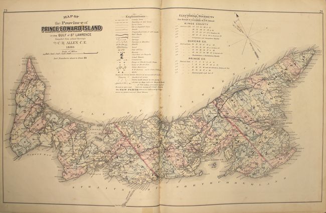
Auction 156, Lot 116
Subject: Prince Edward Island, Atlases
Illustrated Historical Atlas of the Province of Prince Edward Island..., 1880
Size: 14.7 x 17.8 inches (37.3 x 45.2 cm)
Estimate: $2,000 - $2,500
Highly Detailed Atlas of Prince Edward Island
Unsold
Closed on 2/17/2016
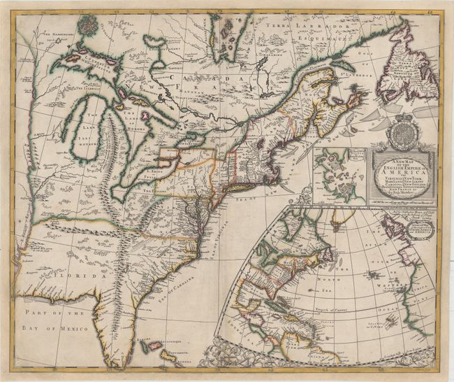
Auction 156, Lot 122
Subject: Colonial Eastern United States & Canada
Morden, Robert
A New Map of the English Empire in America viz Virginia Maryland Carolina Pennsylvania New York New Iarsey New England Newfoundland New France &c., 1695
Size: 23.4 x 19.8 inches (59.4 x 50.3 cm)
Estimate: $14,000 - $16,000
First State of Morden's Rare Map of the American Colonies
Unsold
Closed on 2/17/2016
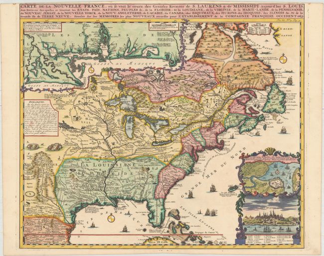
Auction 156, Lot 123
Subject: Colonial Eastern United States & Canada
Chatelain, Henry Abraham
Carte de la Nouvelle France, ou se voit le Cours des Grandes Rivieres de S. Laurens & de Mississipi Aujour d'hui S. Louis, aux Environs des-quelles se Trouvent les Etats, Pais, Nations, Peuples &c..., 1719
Size: 19.1 x 16.6 inches (48.5 x 42.2 cm)
Estimate: $2,200 - $2,500
One of the Most Informative 18th Century Maps of the French Possessions in North America
Sold for: $2,500
Closed on 2/17/2016
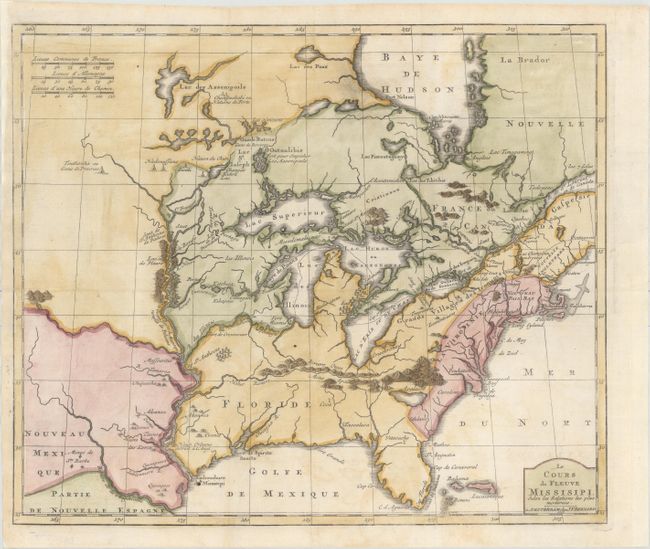
Auction 156, Lot 124
Subject: Colonial Eastern United States & Canada, Great Lakes
Bernard, Jean Frederic
Le Cours du Fleuve Missisipi Selon les Relations les Plus Modernes, 1737
Size: 17.3 x 14.7 inches (43.9 x 37.3 cm)
Estimate: $1,600 - $1,900
Scarce and Desirable Early Hennepin Variant
Sold for: $1,400
Closed on 2/17/2016
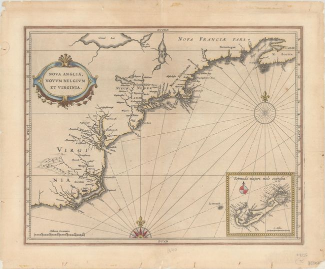
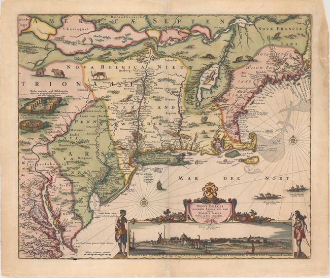
Auction 156, Lot 171
Subject: Colonial New England & Mid-Atlantic
Gerritsz/De Laet
Nova Anglia, Novum Belgium et Virginia, 1630
Size: 14.1 x 11.1 inches (35.8 x 28.2 cm)
Estimate: $5,500 - $7,000
A Map of Extreme Importance in the Cartographic Evolution of North America
Unsold
Closed on 2/17/2016
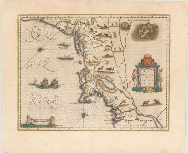
Auction 156, Lot 172
Subject: Colonial New England & Mid-Atlantic
Blaeu, Willem
Nova Belgica et Anglia Nova, 1642
Size: 19.9 x 15.4 inches (50.5 x 39.1 cm)
Estimate: $3,000 - $3,750
Important Map of Colonial New England and the Mid-Atlantic - Full Original Color
Sold for: $2,200
Closed on 2/17/2016
Auction 156, Lot 174
Subject: Colonial New England & Mid-Atlantic
Visscher, Nicolas
Novi Belgii Novaeque Angliae nec non Partis Virginiae Tabula Multis in Locis Emendata, 1684
Size: 21.8 x 18.3 inches (55.4 x 46.5 cm)
Estimate: $8,000 - $9,500
Visscher's Influential Map with Early View of New York City
Sold for: $5,000
Closed on 2/17/2016
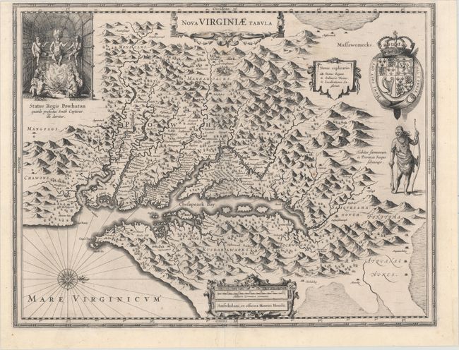
Auction 156, Lot 183
Subject: Colonial Mid-Atlantic United States
Hondius, Henricus
Nova Virginiae Tabula, 1630
Size: 19.6 x 15.1 inches (49.8 x 38.4 cm)
Estimate: $2,000 - $2,300
One of the Most Important 17th Century Maps of the Chesapeake Bay
Sold for: $1,100
Closed on 2/17/2016
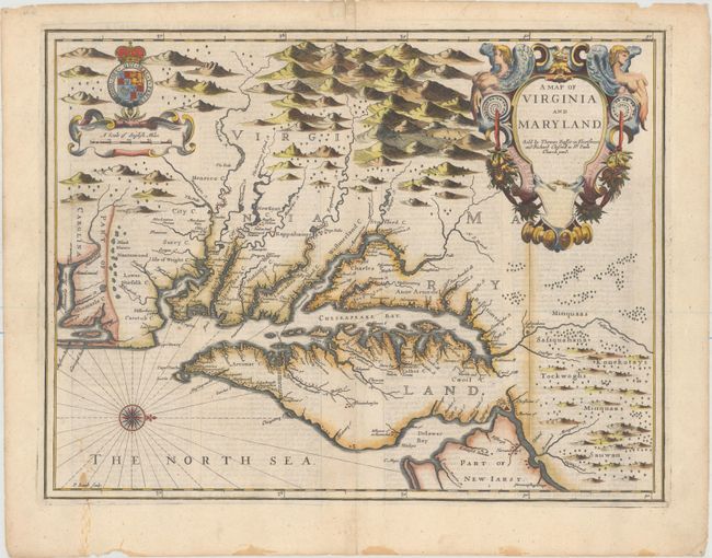
Auction 156, Lot 186
Subject: Colonial Mid-Atlantic United States
Speed/Lamb
A Map of Virginia and Maryland, 1676
Size: 19.4 x 14.9 inches (49.3 x 37.8 cm)
Estimate: $4,000 - $5,000
The First Printed Map to Draw Upon the Legendary Herrman Map of the Chesapeake Bay
Unsold
Closed on 2/17/2016
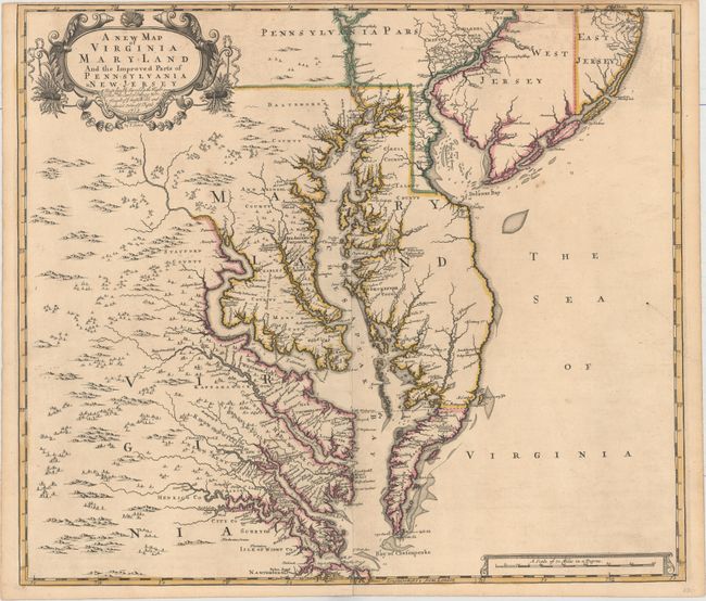
Auction 156, Lot 188
Subject: Colonial Mid-Atlantic United States
Browne/Senex
A New Map of Virginia Mary-land and the Improved Parts of Pennsylvania & New Jersey..., 1719
Size: 21.9 x 19.1 inches (55.6 x 48.5 cm)
Estimate: $5,500 - $6,500
Map of Chesapeake Bay Based on Landmark Herrman Map
Unsold
Closed on 2/17/2016
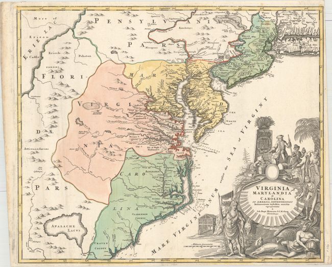
Auction 156, Lot 189
Subject: Colonial Mid-Atlantic United States
Homann, Johann Baptist
Virginia Marylandia et Carolina in America Septentrionali Britannorum Industria Excultae, 1714
Size: 22.9 x 19.3 inches (58.2 x 49 cm)
Estimate: $1,900 - $2,200
Map Created to Promote German Immigration to the New World
Unsold
Closed on 2/17/2016
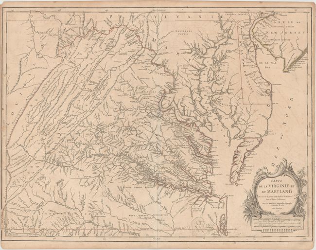
Auction 156, Lot 191
Subject: Colonial Mid-Atlantic United States
Robert de Vaugondy, Didier
Carte de la Virginie et du Maryland Dressee sur la Grande Carte Angloise de Mrs. Josue Fry et Pierre Jefferson..., 1755
Size: 25.4 x 19.1 inches (64.5 x 48.5 cm)
Estimate: $2,200 - $2,500
An Essential Map of Virginia and Maryland
Unsold
Closed on 2/17/2016
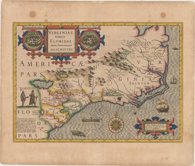
Auction 156, Lot 198
Subject: Colonial Southeast United States
Hondius, Jodocus
Virginiae Item et Floridae Americae Provinciarum, Nova Descriptio, 1628
Size: 19.3 x 13.6 inches (49 x 34.5 cm)
Estimate: $2,200 - $3,000
A Seminal Map of the Southeast and Early American Cartography
Sold for: $1,500
Closed on 2/17/2016
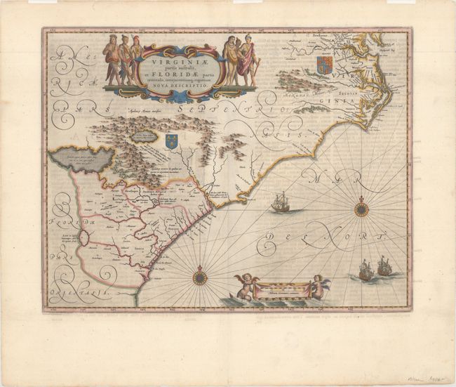
Auction 156, Lot 199
Subject: Colonial Southeast United States
Blaeu, Willem
Virginiae Partis Australis, et Floridae Partis Orientalis, Interjacentiumq Regionum Nova Descriptio, 1662
Size: 19.6 x 15.2 inches (49.8 x 38.6 cm)
Estimate: $1,600 - $1,900
Blaeu's Decorative Map of the Southeast
Sold for: $1,200
Closed on 2/17/2016
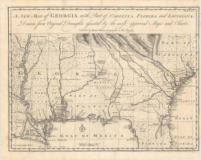
Auction 156, Lot 202
Subject: Colonial Southeast United States
Bowen, Emanuel
A New Map of Georgia, with Part of Carolina, Florida and Louisiana. Drawn from Original Draughts, Assisted by the Most Approved Maps and Charts, 1763
Size: 18.8 x 14.3 inches (47.8 x 36.3 cm)
Estimate: $3,250 - $4,000
Important Map of the Georgia Colony
Sold for: $2,200
Closed on 2/17/2016
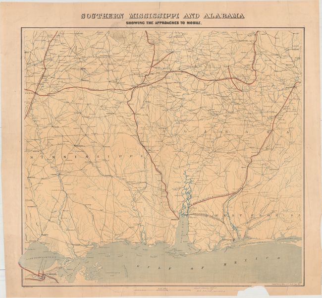
Auction 156, Lot 212
Subject: Southern United States, Civil War
U.S. Coast Survey
Southern Mississippi and Alabama Showing the Approaches to Mobile, 1863
Size: 24.5 x 22.3 inches (62.2 x 56.6 cm)
Estimate: $1,000 - $1,500
First Edition of this Rare Civil War Map
Unsold
Closed on 2/17/2016
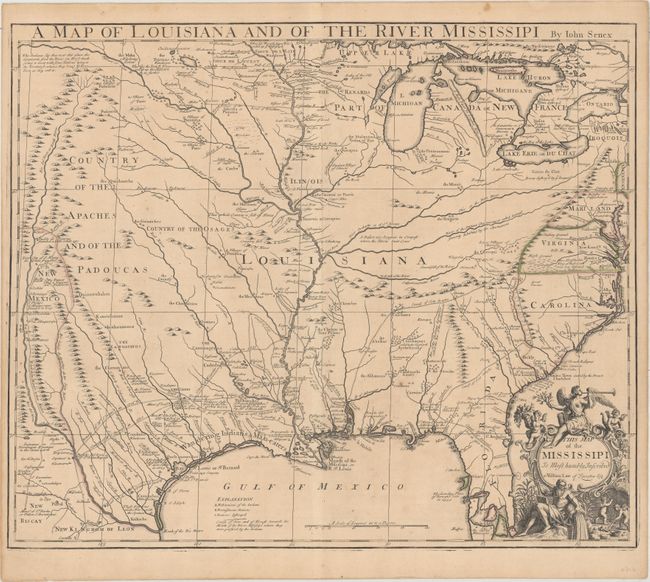
Auction 156, Lot 214
Subject: South Central United States, Louisiana
Senex, John
A Map of Louisiana and of the River Mississipi, 1721
Size: 22.7 x 19.1 inches (57.7 x 48.5 cm)
Estimate: $2,750 - $3,500
Important Map of Colonial Louisiana and the Mississippi River
Sold for: $1,700
Closed on 2/17/2016
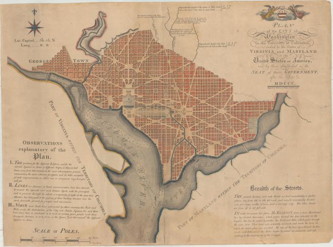
Auction 156, Lot 256
Subject: Washington, D.C.
Thackara, James
Plan of the City of Washington in the Territory of Columbia, Ceded by the States of Virginia and Maryland to the United States of America, and by Them Established as the Seat of Their Government After the Year MDCCC, 1792
Size: 26.4 x 20.3 inches (67.1 x 51.6 cm)
Estimate: $13,000 - $16,000
The First "Official" Plan of Washington
Sold for: $9,000
Closed on 2/17/2016
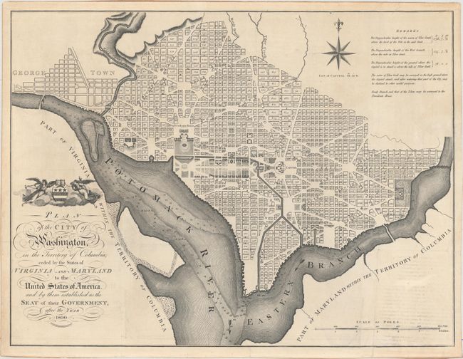
Auction 156, Lot 257
Subject: Washington, D.C.
Russell, John C.
Plan of the City of Washington, in the Territory of Columbia, Ceded by the States of Virginia and Maryland to the United States of America, and by Them Established as the Seat of Their Government, After the Year 1800, 1795
Size: 20.9 x 15.9 inches (53.1 x 40.4 cm)
Estimate: $2,750 - $3,500
Rare, Early Large Format Map of Washington D.C.
Sold for: $1,500
Closed on 2/17/2016
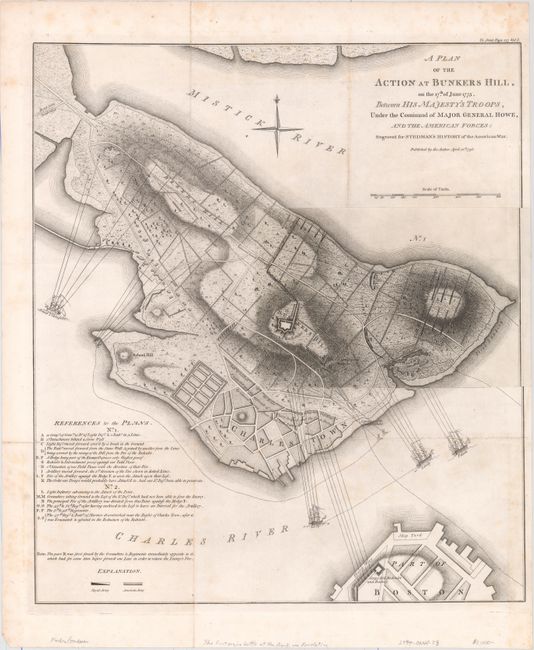
Auction 156, Lot 276
Subject: Boston, Massachusetts
Stedman, Charles
A Plan of the Action at Bunkers Hill, on the 17th of June 1775. Between His Majesty's Troops, Under the Command of Major General Howe, and the American Forces: Engraved for Stedman's History of the American War, 1793
Size: 16.9 x 19.2 inches (42.9 x 48.8 cm)
Estimate: $1,200 - $1,500
The Most Precise and Detailed Plan of the Battle of Bunker Hill
Sold for: $900
Closed on 2/17/2016
94 lots
Page 1 of 2