Subject: Washington, D.C.
Period: 1792 (dated)
Publication:
Color: Hand Color
Size:
26.4 x 20.3 inches
67.1 x 51.6 cm
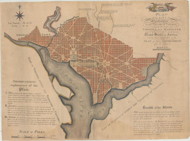
This incredibly important piece is considered the first "official" plan of the city. The original survey work was performed by Andrew Ellicott and the city design was drawn by Peter Charles L'Enfant. However, after a year of difficulties working with L'Enfant, Jefferson and Washington relieved him of his duties and turned all responsibilities over to Ellicott to produce the plan. While L'Enfant's name has been entirely removed from this work, the vision for the city was essentially his own. Once the plan was completed in 1791, it was handed over to the engravers James Thackara & John Vallance in Philadelphia, as well as Samuel Blodget in Boston (who employed Samuel Hill to engrave the plan). Both teams produced small and large versions of the plan. The larger plans are often referred to as the "Philadelphia Plan" and the "Boston Plan." This is the second state of the Philadelphia plan which includes soundings in the Potomac River as requested by Washington.
The plan itself shows the layout of streets including the long diagonals. Washington is bordered by the Potomak (Potomac) River and the Eastern Branch, now the Anacostia River. Georgetown, at the left and northwest of Rock Creek, is separately labeled. Reedy Branch and Tiber Creek are shown to the north outside of the street pattern. Each block is numbered. A few major buildings including the Capitol and the Presidents House are labeled; others are merely outlined. The proposed landscape design for the Mall is shown with considerable detail. At top left is an eight-pointed compass indicator surmounted by a fleur-de-lys. Above the title is George Washington’s coat of arms supported by Fame and Liberty. At the lower left is a distance Scale of Poles. Remarks at top concern the tide of Tiber Creek and how water could be provided to the city.
Cataloger's Note: This map was brought to the Library of Congress to physically compare it against their examples. The size, paper, and coat of arms watermark and location of watermark are virtually identical.
References: Wheat & Brun #531; Phillips (DC) #PW14; Phillips (Maps) p. 1002; Schwartz & Ehrenberg plt. 132; Baynton-Williams “Plans of Washington, D.C.”, MapForum.com, Issue 12, map 5b
Condition: B
Light damp stains enter the image at top and bottom as well as a 5" wide section along the centerfold. There is a 2" edge tear at bottom that has been repaired on verso with old paper, a short printer's crease at right, and several tiny wormholes only visible when held to light. The map has several soft crease lines from where a previous owner folded the map.