Showing Featured Lots(remove filter)
Filtered by Category:United States(Show All Categories)
Showing results for:Auction 192
Catalog Archive
15 lots
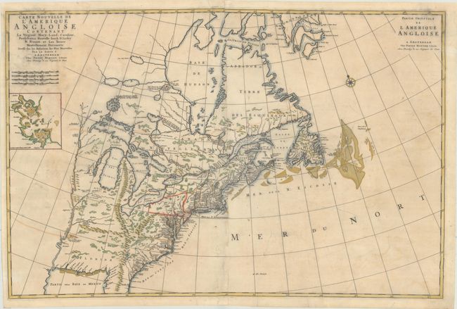
Auction 192, Lot 124
Subject: Colonial Eastern United States & Canada
Mortier, Pierre
Carte Nouvelle de l'Amerique Angloise Contenant la Virginie, Mary-Land, Caroline, Pensylvania Nouvelle Iorck. N: Iarsey N: France, et les Terres Nouvellement Decouerte..., 1700
Size: 35.4 x 23.4 inches (89.9 x 59.4 cm)
Estimate: $1,800 - $2,200
A Map Showing Fascinating Geographic Misconceptions
Sold for: $1,300
Closed on 4/26/2023
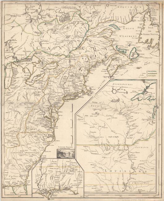
Auction 192, Lot 126
Subject: Colonial Eastern United States & Canada
Le Rouge, George Louis
[Canada et Louisiane], 1755
Size: 19.6 x 24.3 inches (49.8 x 61.7 cm)
Estimate: $1,200 - $1,500
Rare First State of Uncommon French & Indian War Map
Sold for: $750
Closed on 4/26/2023
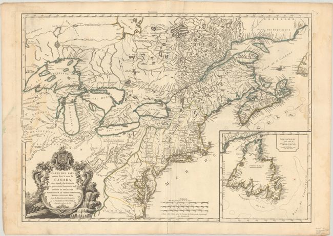
Auction 192, Lot 129
Subject: Colonial Northeastern United States & Canada
Robert de Vaugondy, Didier
Carte des Pays Connus sous le Nom de Canada, dans Laquelle sont Distinguees les Possessions Francoises, & Angl?..., 1755
Size: 26.4 x 18.9 inches (67.1 x 48 cm)
Estimate: $2,300 - $2,750
A Separately Issued, French Political Propaganda Map at the Outset of the French & Indian War
Unsold
Closed on 4/26/2023
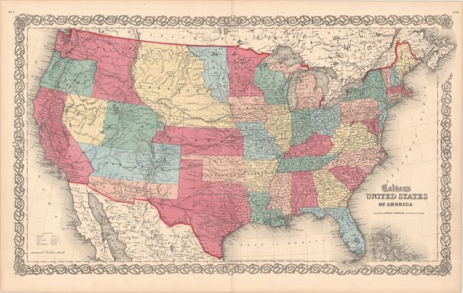
Auction 192, Lot 147
Subject: United States
Johnson & Browning
Colton's United States of America, 1859
Size: 26.4 x 15.7 inches (67.1 x 39.9 cm)
Estimate: $750 - $900
Scarce Map Featuring Colona
Sold for: $850
Closed on 4/26/2023
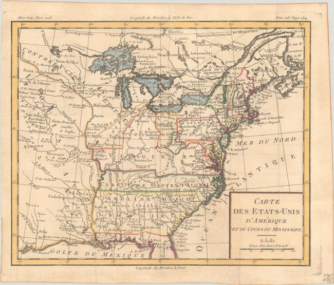
Auction 192, Lot 164
Subject: Eastern United States, Franklin
Brion de la Tour, Louis
Carte des Etats-Unis d'Amerique et du Cours du Mississipi, 1788
Size: 10.7 x 8.8 inches (27.2 x 22.4 cm)
Estimate: $950 - $1,200
One of the Earliest Maps to Feature the State of Franklin
Sold for: $1,100
Closed on 4/26/2023
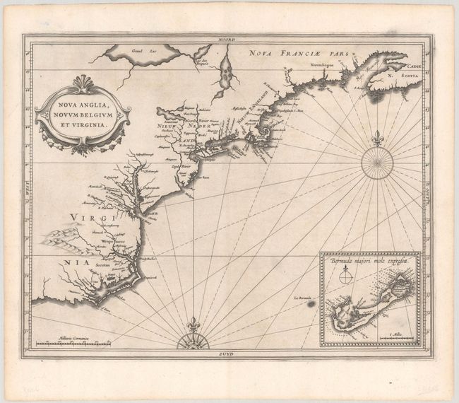
Auction 192, Lot 169
Subject: Colonial New England & Mid-Atlantic United States
Gerritsz/De Laet
Nova Anglia, Novum Belgium et Virginia, 1630
Size: 14 x 11 inches (35.6 x 27.9 cm)
Estimate: $6,000 - $7,500
A Critically Important Map in the Cartographic Evolution of North America
Sold for: $4,500
Closed on 4/26/2023
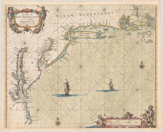
Auction 192, Lot 170
Subject: Colonial New England & Mid-Atlantic United States
Goos, Pieter
Pas Caerte van Nieu Nederlandt en de Engelsche Virginies Van Cabo Cod tot Cabo Canrick, 1666
Size: 20.9 x 16.9 inches (53.1 x 42.9 cm)
Estimate: $7,000 - $8,500
Goos' Gorgeous Chart of the Mid-Atlantic & New England
Unsold
Closed on 4/26/2023
Auction 192, Lot 177
Subject: Colonial Mid-Atlantic United States
Jansson, Jan
Virginia, 1648
Size: 7.6 x 5.8 inches (19.3 x 14.7 cm)
Estimate: $750 - $900
Rare Edition of Atlas Minor Map of Virginia
Sold for: $1,100
Closed on 4/26/2023
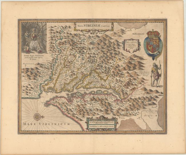
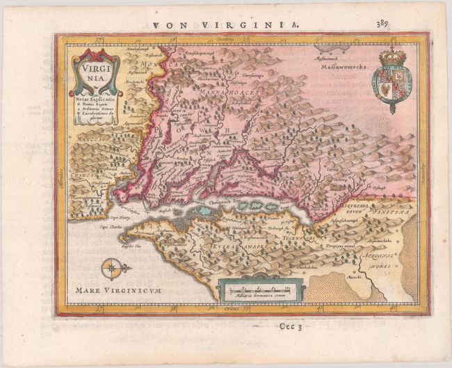
Auction 192, Lot 178
Subject: Colonial Mid-Atlantic United States
Hondius, Henricus
Nova Virginiae Tabula, 1652
Size: 19.4 x 15 inches (49.3 x 38.1 cm)
Estimate: $1,600 - $1,900
One of the Most Important 17th Century Maps of the Chesapeake Bay
Sold for: $1,200
Closed on 4/26/2023
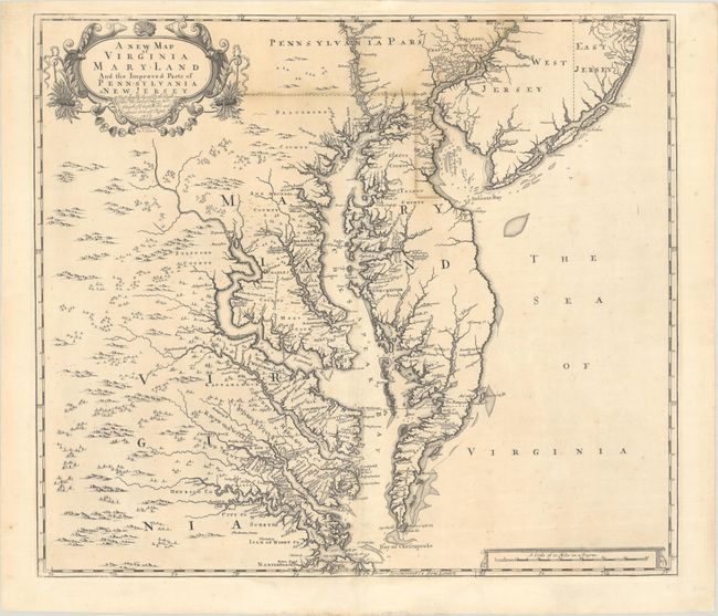
Auction 192, Lot 180
Subject: Colonial Mid-Atlantic United States
Browne/Senex
A New Map of Virginia Mary-Land and the Improved Parts of Pennsylvania & New Jersey..., 1719
Size: 21.8 x 19.1 inches (55.4 x 48.5 cm)
Estimate: $3,500 - $4,250
Map of Chesapeake Bay Based on Landmark Herrman Map
Unsold
Closed on 4/26/2023
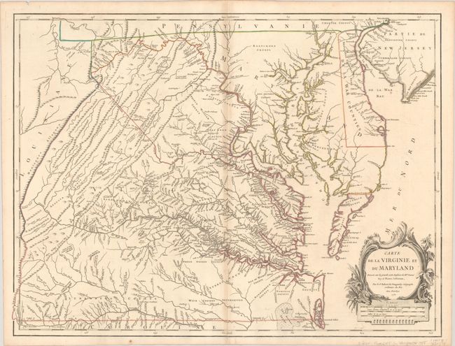
Auction 192, Lot 181
Subject: Colonial Mid-Atlantic United States
Robert de Vaugondy, Didier
Carte de la Virginie et du Maryland Dressee sur la Grande Carte Angloise de Mrs. Josue Fry et Pierre Jefferson, 1755
Size: 25.5 x 19.2 inches (64.8 x 48.8 cm)
Estimate: $2,300 - $2,750
First State of Robert de Vaugondy's Essential Map of Virginia and Maryland
Sold for: $1,700
Closed on 4/26/2023
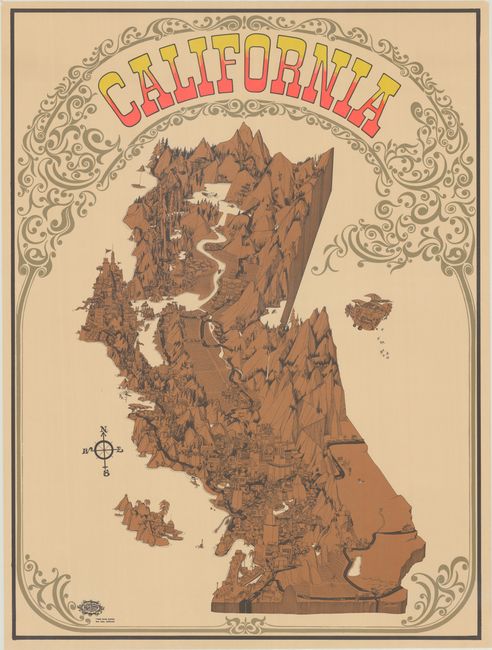
Auction 192, Lot 225
Subject: California
California, 1968
Size: 27.9 x 37.5 inches (70.9 x 95.3 cm)
Estimate: $1,100 - $1,400
A Celebration of the California Music Scene
Sold for: $800
Closed on 4/26/2023
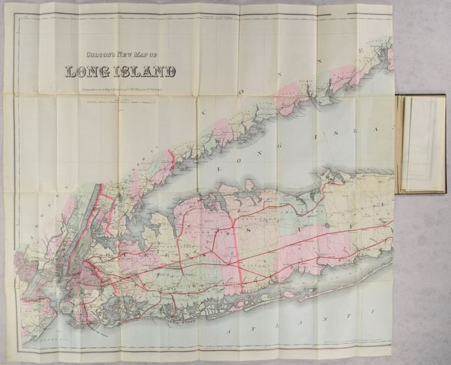
Auction 192, Lot 284
Subject: Long Island, New York
Colton, G.W. & C.B.
Colton's New Map of Long Island, 1886
Size: 64 x 30 inches (162.6 x 76.2 cm)
Estimate: $2,750 - $3,500
Monumental Map of Long Island in Mint Condition
Sold for: $1,400
Closed on 4/26/2023
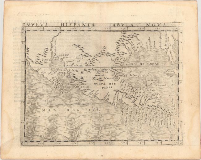
Auction 192, Lot 313
Subject: Southern United States, Mexico & Central America
Gastaldi, Giacomo
Nueva Hispania Tabula Nova, 1548
Size: 6.8 x 5 inches (17.3 x 12.7 cm)
Estimate: $3,250 - $4,000
The First Copperplate Map Devoted to North America
Sold for: $2,400
Closed on 4/26/2023
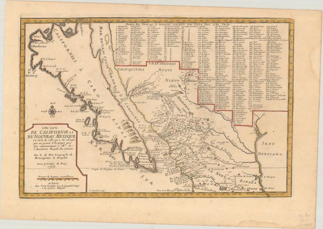
Auction 192, Lot 318
Subject: Southwestern United States & Mexico, California
Fer, Nicolas de
Cette Carte de Californie et du Nouveau Mexique est Tiree de celle qui a ete Envoyee par un Grand d'Espagne pour etre Communiquee a Mrs. de l'Academie Royale des Sciences, 1705
Size: 13.5 x 9 inches (34.3 x 22.9 cm)
Estimate: $1,100 - $1,400
De Fer's Important Map of the Island of California
Sold for: $700
Closed on 4/26/2023
15 lots