Showing Featured Lots(remove filter)
Filtered by Category:United States(Show All Categories)
Showing results for:Auction 186
Catalog Archive
21 lots
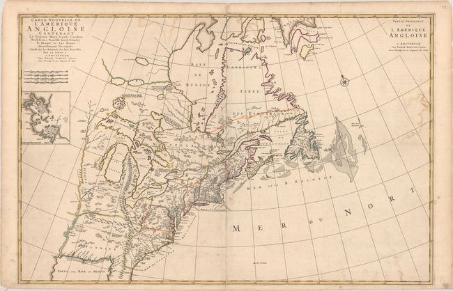
Auction 186, Lot 130
Subject: Colonial Eastern United States & Canada
Mortier, Pierre
Carte Nouvelle de l'Amerique Angloise Contenant la Virginie, Mary-Land, Caroline, Pensylvania Nouvelle Iorck, N: Iarsey N: France, et les Terres Nouvellement Decouerte..., 1700
Size: 35.8 x 23.4 inches (90.9 x 59.4 cm)
Estimate: $2,000 - $2,300
A Map Showing Fascinating Geographic Misconceptions
Sold for: $1,500
Closed on 2/9/2022
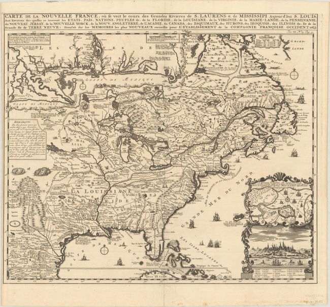
Auction 186, Lot 131
Subject: Colonial Eastern United States & Canada
Chatelain, Henry Abraham
Carte de la Nouvelle France, ou se voit le Cours des Grandes Rivieres de S. Laurens & de Mississipi Aujour d'hui S. Louis, aux Environs des-quelles se Trouvent les Etats, Pais, Nations, Peuples &c..., 1720
Size: 19.3 x 16.6 inches (49 x 42.2 cm)
Estimate: $2,400 - $3,000
One of the Most Informative 18th Century Maps of the French Possessions in North America
Sold for: $2,100
Closed on 2/9/2022
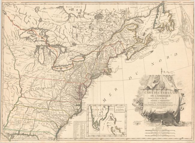
Auction 186, Lot 137
Subject: Eastern United States & Canada
Lattre, Jean
Carte des Etats-Unis de l'Amerique Suivant le Traite de Paix de ... Dediee et Presentee a S. Excellence Mr. Benjamin Franklin..., 1791
Size: 30 x 21.9 inches (76.2 x 55.6 cm)
Estimate: $5,500 - $7,000
First French Map of the New United States
Sold for: $7,000
Closed on 2/9/2022
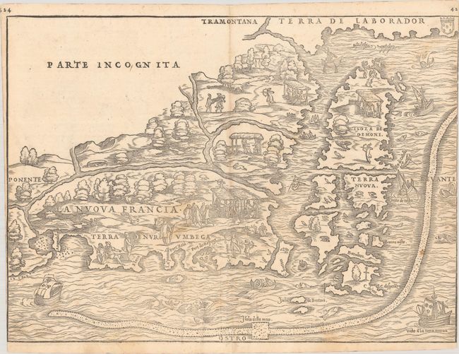
Auction 186, Lot 143
Subject: Colonial Northeastern United States & Canada
Gastaldi/Ramusio
La Nuova Francia, 1556
Size: 14.8 x 10.8 inches (37.6 x 27.4 cm)
Estimate: $5,000 - $6,500
Rare First State of the First Printed Map to Focus on New England and New France
Sold for: $3,500
Closed on 2/9/2022
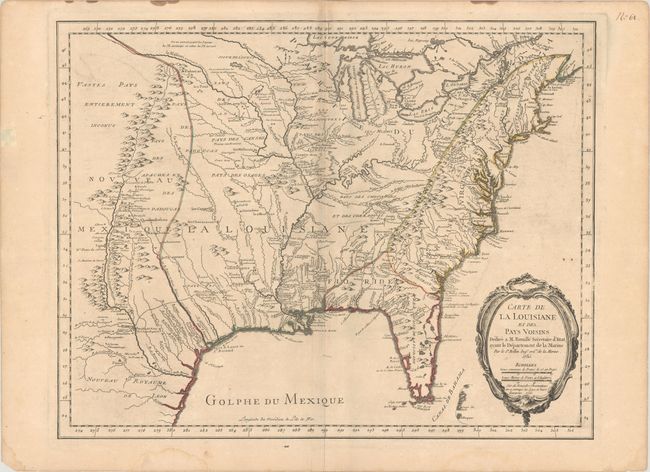
Auction 186, Lot 171
Subject: Colonial Eastern United States
Bellin, Jacques Nicolas
Carte de la Louisiane et des Pays Voisins Dediee a M. Rouille Secretaire d'Etat, Ayant le Departement de la Marine, 1755
Size: 24.1 x 18.8 inches (61.2 x 47.8 cm)
Estimate: $1,200 - $1,500
Bellin's Scarce French and Indian War-Era Map of the Colonial United States
Sold for: $1,200
Closed on 2/9/2022
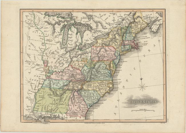
Auction 186, Lot 180
Subject: Eastern United States, Franklin
Neele, Samuel John
United States, 1813
Size: 11.3 x 8.9 inches (28.7 x 22.6 cm)
Estimate: $1,100 - $1,400
Map Depicting Proposed State of "Franklinia" and Other Short-Lived Territories
Unsold
Closed on 2/9/2022
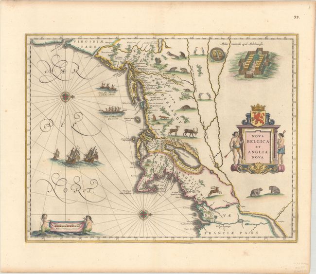
Auction 186, Lot 189
Subject: Colonial New England & Mid-Atlantic United States
Blaeu, Willem
Nova Belgica et Anglia Nova, 1635
Size: 19.9 x 15.3 inches (50.5 x 38.9 cm)
Estimate: $2,000 - $2,300
Important Map of Colonial New England and the Mid-Atlantic
Sold for: $2,750
Closed on 2/9/2022
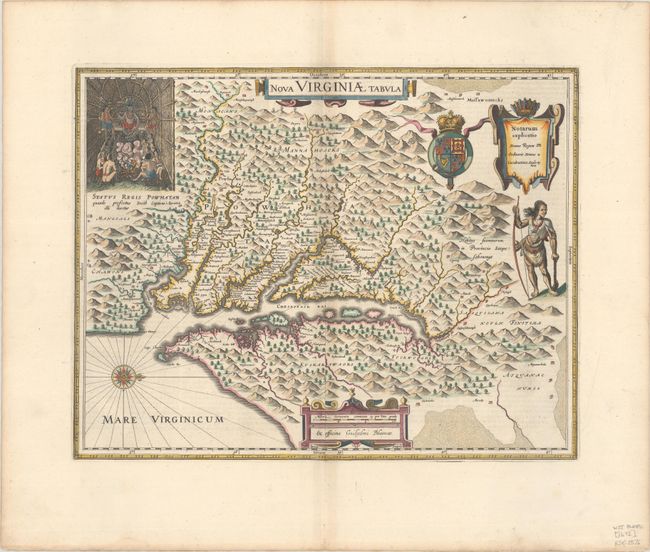
Auction 186, Lot 196
Subject: Colonial Mid-Atlantic United States
Hondius/Blaeu
Nova Virginiae Tabula, 1647
Size: 18.8 x 14.8 inches (47.8 x 37.6 cm)
Estimate: $2,000 - $2,300
One of the Most Important 17th Century Maps of the Chesapeake Bay
Sold for: $1,500
Closed on 2/9/2022
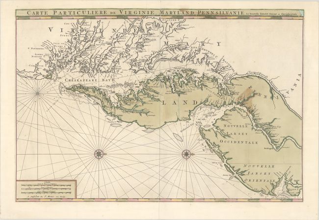
Auction 186, Lot 197
Subject: Colonial Mid-Atlantic United States
Jaillot/Mortier
Carte Particuliere de Virginie, Maryland, Pennsilvanie, la Nouvelle Iarsey. Orient et Occidentale, 1700
Size: 31.5 x 21.2 inches (80 x 53.8 cm)
Estimate: $4,000 - $5,000
One of the Most Beautiful Charts of Maryland and the Chesapeake Bay
Sold for: $3,000
Closed on 2/9/2022
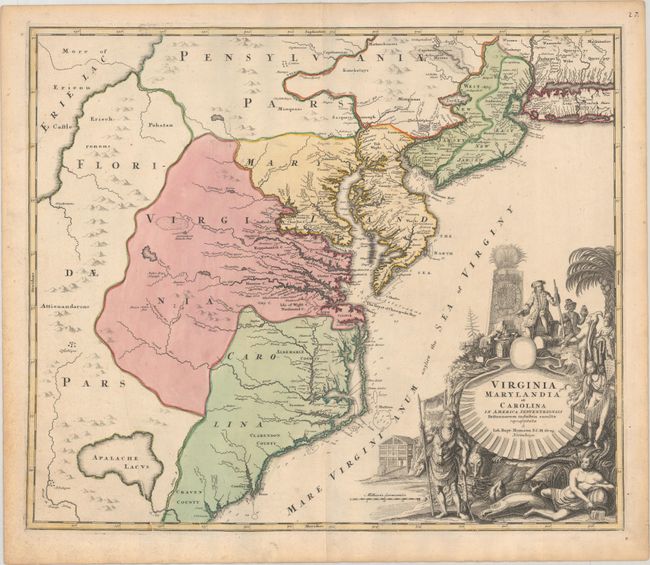
Auction 186, Lot 198
Subject: Colonial Mid-Atlantic United States
Homann, Johann Baptist
Virginia Marylandia et Carolina in America Septentrionali Britannorum Industria Excultae Repraesentatae, 1730
Size: 22.8 x 19.1 inches (57.9 x 48.5 cm)
Estimate: $1,500 - $1,800
Map Created to Promote German Immigration to the New World
Sold for: $1,100
Closed on 2/9/2022
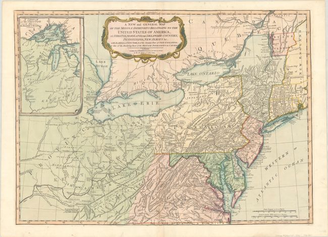
Auction 186, Lot 203
Subject: Mid-Atlantic United States & Great Lakes
Laurie & Whittle
A New and General Map of the Middle Dominions Belonging to the United States of America, viz. Virginia, Maryland, the Delaware-Counties, Pennsylvania, New Jersey &c. with the Addition of New York, & of the Greatest Part of New England…, 1794
Size: 26 x 18.8 inches (66 x 47.8 cm)
Estimate: $1,200 - $1,500
Laurie & Whittle's Popular Map Depicting the "New" United States
Sold for: $750
Closed on 2/9/2022
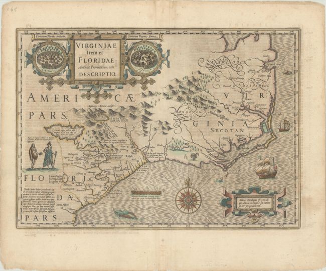
Auction 186, Lot 206
Subject: Colonial Southeast United States
Hondius, Jodocus
Virginiae Item et Floridae Americae Provinciarum, Nova Descriptio, 1634
Size: 19.1 x 13.6 inches (48.5 x 34.5 cm)
Estimate: $1,800 - $2,100
A Seminal Map of the Southeast and Early American Cartography - Full Contemporary Color
Sold for: $1,200
Closed on 2/9/2022
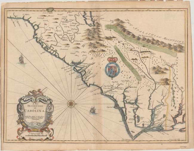
Auction 186, Lot 208
Subject: Colonial Southeast United States
Speed/Lamb
A New Description of Carolina, 1676
Size: 20.1 x 14.9 inches (51.1 x 37.8 cm)
Estimate: $2,400 - $3,000
Speed's Map of the Carolinas Based Upon the Lords Proprietor's Map
Sold for: $1,800
Closed on 2/9/2022
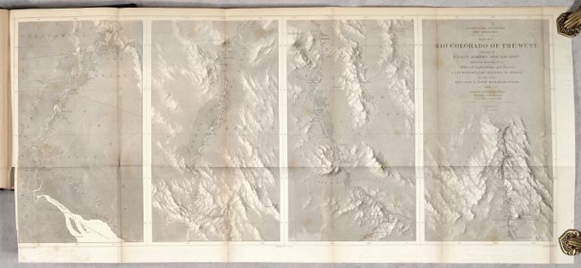
Auction 186, Lot 226
Subject: Southwestern United States
Ives, Joseph C. (Lt.)
[4 Maps with Report] ] Map No. 1 [and] Map No. 2 Rio Colorado of the West... [and] Geological Map No. 1 [and] Geological Map No. 2 Rio Colorado of the West [bound in] Report upon the Colorado River of the West, Explored 1857 and 1858…, 1861
Size: 34.5 x 14.6 inches (87.6 x 37.1 cm)
Estimate: $700 - $850
Complete Ives Report with Scarce Geological Maps
Sold for: $350
Closed on 2/9/2022
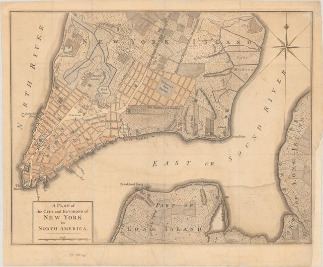
Auction 186, Lot 295
Subject: New York City, New York, Revolutionary War
Anon.
A Plan of the City and Environs of New York in North America, 1776
Size: 14.4 x 11.2 inches (36.6 x 28.4 cm)
Estimate: $2,000 - $2,300
Revolutionary War-Era Plan of New York City
Sold for: $1,500
Closed on 2/9/2022
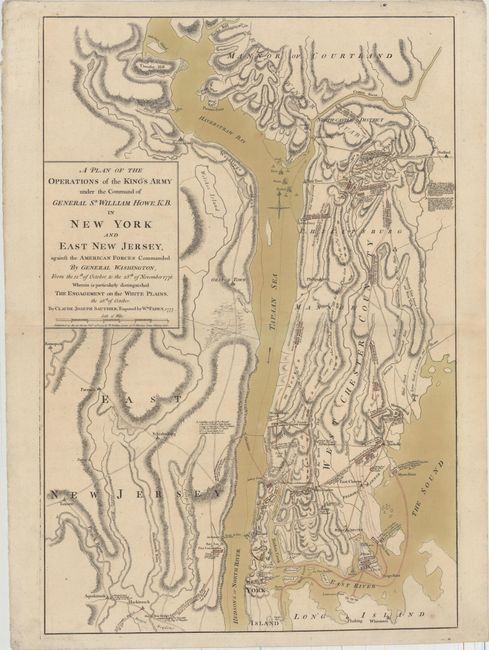
Auction 186, Lot 296
Subject: Colonial New York, Revolutionary War
Sauthier/Faden
A Plan of the Operations of the King's Army Under the Command of General Sr. William Howe, K.B. in New York and East New Jersey, Against the American Forces Commanded by General Washington..., 1777
Size: 19.3 x 28.7 inches (49 x 72.9 cm)
Estimate: $7,000 - $8,500
Important Revolutionary War Map of the Battle of White Plains
Sold for: $5,000
Closed on 2/9/2022
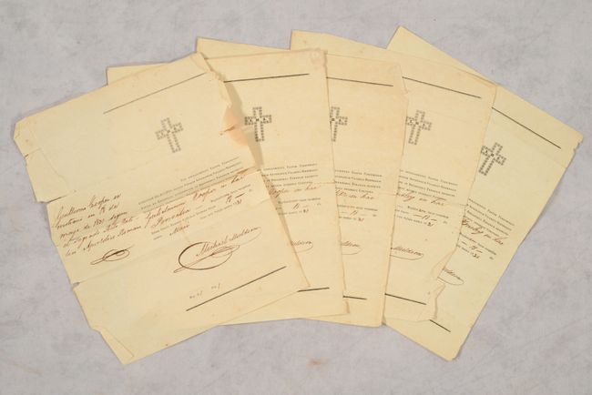
Auction 186, Lot 326
Subject: Austin's Colony, Texas, Documents
[5 Certificates of Baptism Signed by Michael Muldoon in Austin's Colony], 1831
Size: 8 x 9.7 inches (20.3 x 24.6 cm)
Estimate: $2,000 - $2,500
Important Documents Enabling Land Ownership in Austin's Colony
Sold for: $17,000
Closed on 2/9/2022
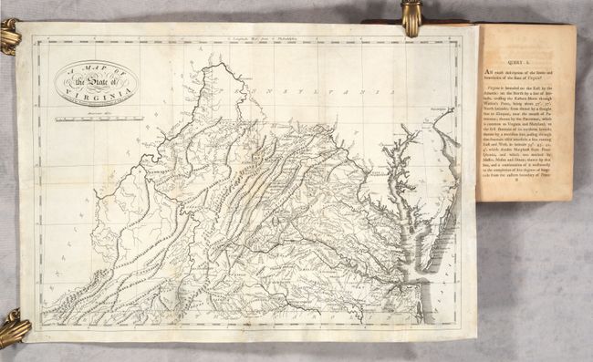
Auction 186, Lot 329
Subject: Virginia
Jefferson, Thomas
[Map in Book] A Map of the State of Virginia... [in] Notes on the State of Virginia, 1801
Size: 19.6 x 13.4 inches (49.8 x 34 cm)
Estimate: $2,400 - $3,000
"First Hot-Pressed Edition" of Jefferson's Famous Work
Sold for: $1,500
Closed on 2/9/2022
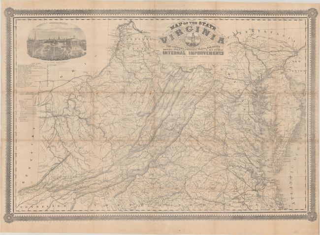
Auction 186, Lot 330
Subject: Virginia, Civil War
West & Johnston
Map of the State of Virginia Containing the Counties, Principal Towns, Railroads Rivers, Canals & All Other Internal Improvements, 1862
Size: 37.4 x 25.6 inches (95 x 65 cm)
Estimate: $8,000 - $9,500
Rare Civil War Map Based on Bucholtz Map of Virginia
Unsold
Closed on 2/9/2022
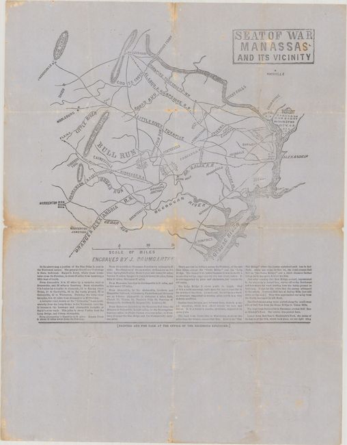
Auction 186, Lot 331
Subject: Northern Virginia, Civil War
Seat of War Manassas and Its Vicinity, 1861
Size: 9.8 x 10.4 inches (24.9 x 26.4 cm)
Estimate: $2,400 - $3,000
Confederate Broadside of the First Major Battle of the Civil War
Unsold
Closed on 2/9/2022
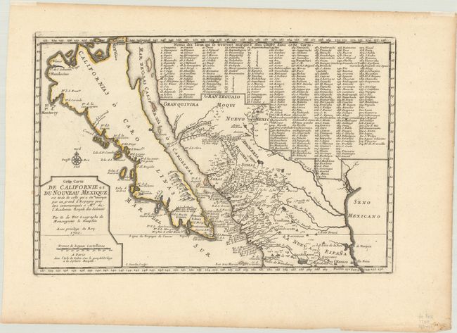
Auction 186, Lot 341
Subject: Southwestern United States & Mexico, California
Fer, Nicolas de
Cette Carte de Californie et du Nouveau Mexique, 1700
Size: 13.4 x 8.9 inches (34 x 22.6 cm)
Estimate: $1,200 - $1,500
De Fer's Important Map of the Island of California
Sold for: $1,100
Closed on 2/9/2022
21 lots