Showing Featured Lots(remove filter)
Filtered by Category:United States(Show All Categories)
Showing results for:Auction 169
Catalog Archive
19 lots
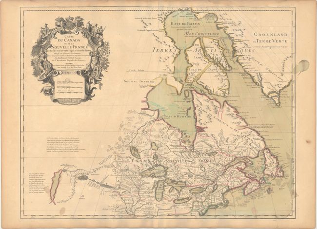
Auction 169, Lot 130
Subject: Colonial Northeastern United States & Canada, Great Lakes
Delisle, Guillaume
Carte du Canada ou de la Nouvelle France et des Decouvertes qui y ont ete Faites..., 1703
Size: 25.6 x 19.6 inches (65 x 49.8 cm)
Estimate: $2,200 - $2,500
Delisle's Seminal Map of Canada and the Great Lakes
Sold for: $1,600
Closed on 9/12/2018
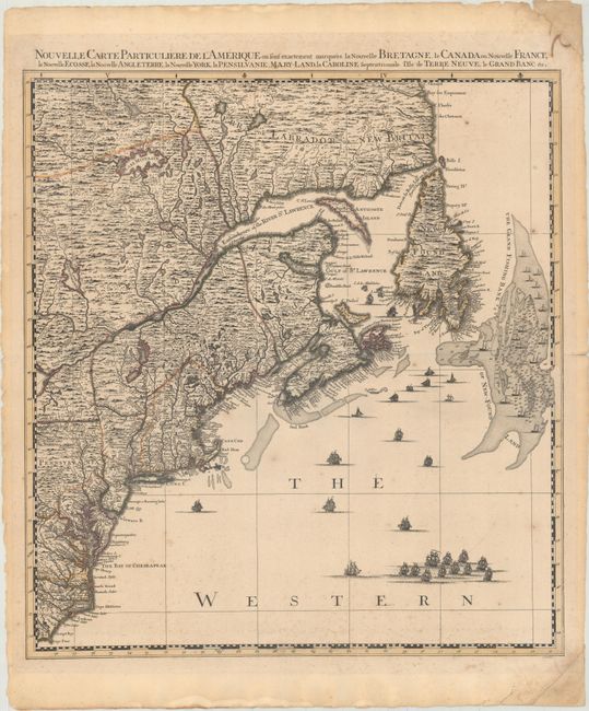
Auction 169, Lot 133
Subject: Colonial Northeastern United States & Canada
Popple/Covens & Mortier
Nouvelle Carte Particuliere de l'Amerique ou sont Exactement Marquees la Nouvelle Bretagne, le Canada ou Nouvelle France, la Nouvelle Ecosse, la Nouvelle Angleterre, la Nouvelle York..., 1741
Size: 20.5 x 22.4 inches (52.1 x 56.9 cm)
Estimate: $2,400 - $3,000
The Northeastern Sheet of the Reduced-Size Edition of Popple's Map
Unsold
Closed on 9/12/2018
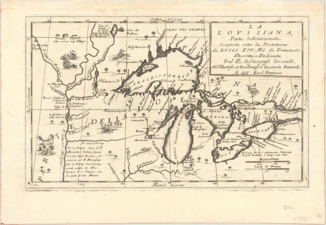
Auction 169, Lot 145
Subject: Colonial Central United States & Canada, Great Lakes
Coronelli, Vincenzo Maria
La Louisiana, Parte Settentrionalle, Scoperta Sotto la Protettione di Luigi XIV, Re di Francia, Etc., 1695
Size: 16.6 x 10.1 inches (42.2 x 25.7 cm)
Estimate: $3,500 - $4,250
Coronelli's Important Map of the Great Lakes & Upper Mississippi River Valley
Sold for: $4,000
Closed on 9/12/2018
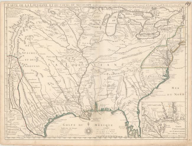
Auction 169, Lot 159
Subject: Colonial Eastern United States
Delisle, Guillaume
Carte de la Louisiane et du Cours du Mississipi Dressee sur un Grand Nombre de Memoires Entrautres sur ceux de Mr. le Maire, 1718
Size: 25.3 x 19.1 inches (64.3 x 48.5 cm)
Estimate: $6,000 - $7,500
A Foundation Map for the Mississippi Valley and the First Appearance of Texas on a Printed Map
Sold for: $4,000
Closed on 9/12/2018
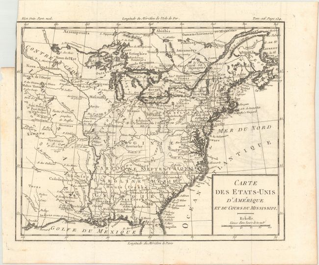
Auction 169, Lot 162
Subject: Eastern United States, Franklin
Brion de la Tour, Louis
Carte des Etats-Unis d'Amerique et du Cours du Mississipi, 1788
Size: 10.6 x 8.7 inches (26.9 x 22.1 cm)
Estimate: $900 - $1,100
One of the Earliest Maps to Feature the State of Franklin
Unsold
Closed on 9/12/2018
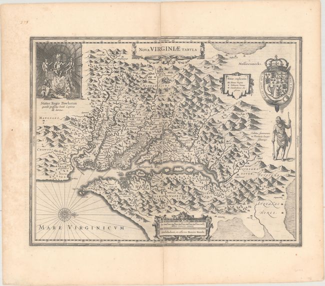
Auction 169, Lot 177
Subject: Colonial Mid-Atlantic United States
Hondius, Henricus
Nova Virginiae Tabula, 1652
Size: 19.4 x 15 inches (49.3 x 38.1 cm)
Estimate: $1,600 - $1,900
One of the Most Important 17th Century Maps of the Chesapeake Bay
Sold for: $1,200
Closed on 9/12/2018
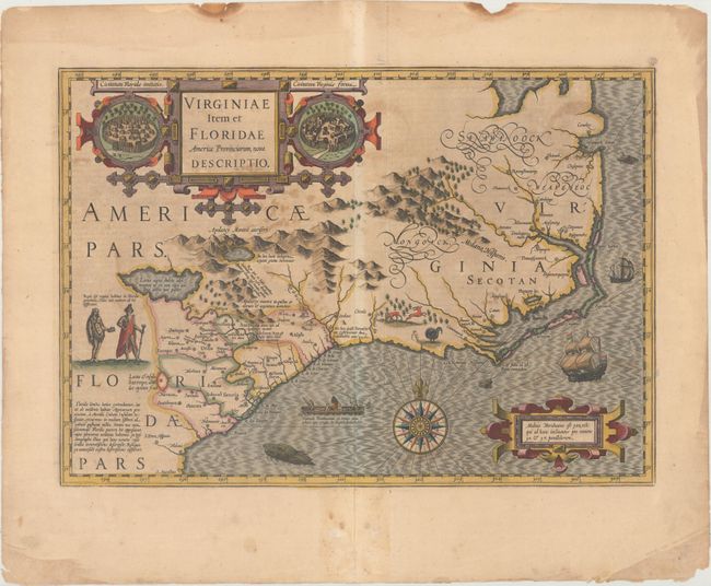
Auction 169, Lot 188
Subject: Colonial Southeast United States
Hondius, Jodocus
Virginiae Item et Floridae Americae Provinciarum, Nova Descriptio, 1628
Size: 19.2 x 13.6 inches (48.8 x 34.5 cm)
Estimate: $1,800 - $2,100
A Seminal Map of the Southeast and Early American Cartography
Sold for: $900
Closed on 9/12/2018
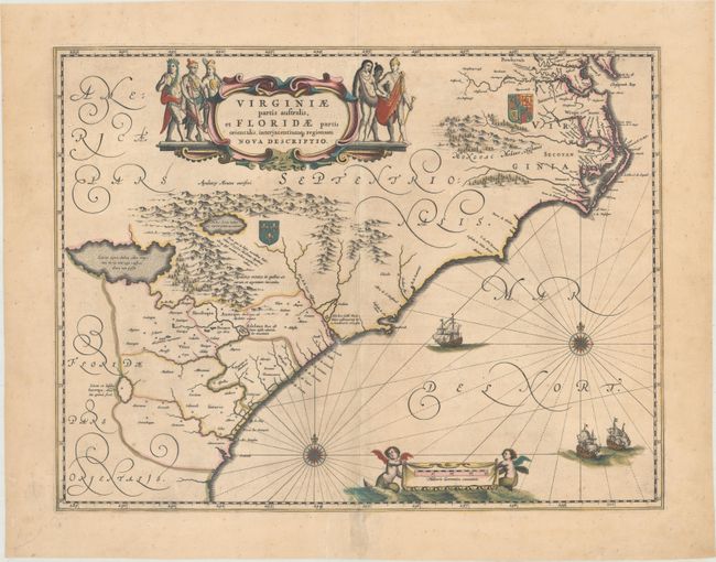
Auction 169, Lot 189
Subject: Colonial Southeast United States
Blaeu, Willem
Virginiae Partis Australis, et Floridae Partis Orientalis, Interjacentiumq Regionum Nova Descriptio, 1680
Size: 19.8 x 15.1 inches (50.3 x 38.4 cm)
Estimate: $1,100 - $1,400
Blaeu's Decorative Map of the Southeast
Sold for: $800
Closed on 9/12/2018
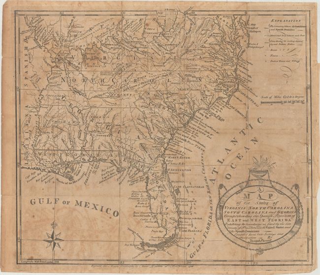
Auction 169, Lot 198
Subject: Southern United States, Franklin
Morse, Jedidiah (Rev.)
[Lot of 2] A Map of the States of Virginia, North Carolina, South Carolina and Georgia; Comprehending the Spanish Provinces of East and West Florida... [with] The American Geography..., 1789
Size: 14.4 x 12.3 inches (36.6 x 31.2 cm)
Estimate: $700 - $850
Rare First State of Purcell's Map Locating the Proposed State of Franklin
Sold for: $600
Closed on 9/12/2018
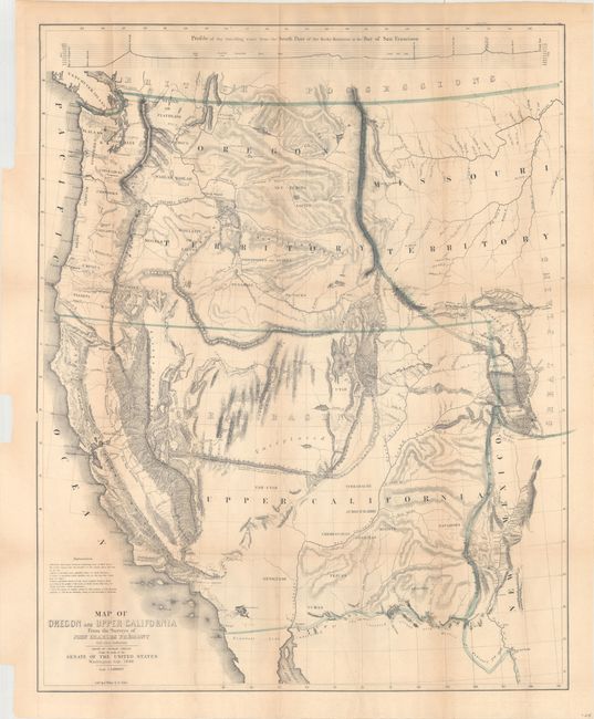
Auction 169, Lot 216
Subject: Western United States
Fremont/Preuss
Map of Oregon and Upper California from the Surveys of John Charles Fremont and Other Authorities, 1848
Size: 26.8 x 33.3 inches (68.1 x 84.6 cm)
Estimate: $1,500 - $1,800
Fremont's Map of the American West
Sold for: $1,100
Closed on 9/12/2018
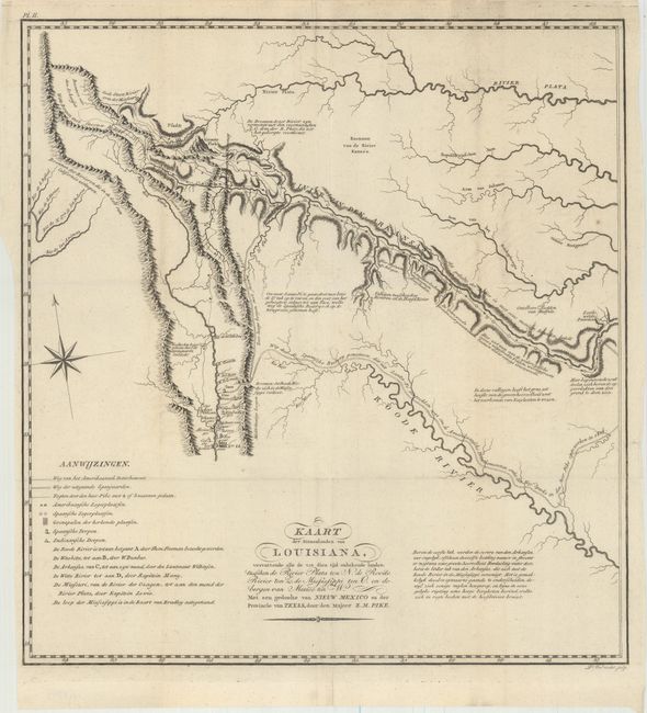
Auction 169, Lot 220
Subject: Southwestern United States
Pike, Zebulon
Kaart der Binnenlanden van Louisiana, Vervattende alle de tot dien tijd Onbekende Landen..., 1812
Size: 14.7 x 15.6 inches (37.3 x 39.6 cm)
Estimate: $2,500 - $3,250
A Cornerstone Map of Early Western Exploration
Unsold
Closed on 9/12/2018
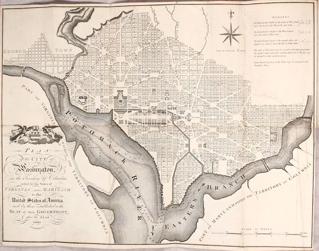
Auction 169, Lot 235
Subject: Washington, D.C.
Russell, John C.
Plan of the City of Washington in the Territory of Columbia... [bound in] An Historical Geographical, Commercial, and Philosophical View of the American United States, and of the European Settlements in America and the West-Indies... Vol. III, 1795
Size: 5.3 x 8.5 inches (13.5 x 21.6 cm)
Estimate: $2,750 - $3,500
Uncommon, Early Large-Format Map of Washington D.C.
Unsold
Closed on 9/12/2018
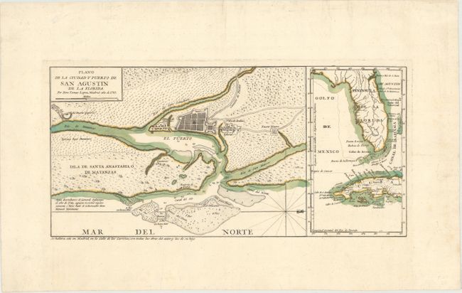
Auction 169, Lot 244
Subject: St. Augustine, Florida
Lopez de Vargas Machuca, Thomas (don)
Plano de la Ciudad y Puerto de San Agustin de la Florida, 1783
Size: 15.3 x 7.4 inches (38.9 x 18.8 cm)
Estimate: $700 - $1,000
Map Showing First Legally Sanctioned Free Black Community in US
Sold for: $500
Closed on 9/12/2018
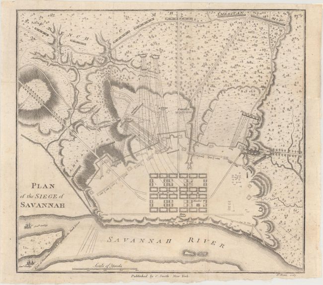
Auction 169, Lot 245
Subject: Savannah, Georgia, Revolutionary War
Smith, Charles
Plan of the Siege of Savannah, 1796
Size: 9.1 x 8.4 inches (23.1 x 21.3 cm)
Estimate: $1,400 - $1,700
Rare Revolutionary War Plan Showing the Siege of Savannah
Sold for: $1,600
Closed on 9/12/2018
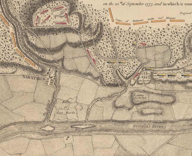
Auction 169, Lot 276
Subject: Colonial Saratoga, New York, Revolutionary War
Faden, William
Plan of the Position Which the Army Under Lt. Genl. Burgoine Took at Saratoga on the 10th of September 1777, and In Which It Remained Till the Convention Was Signed, 1780
Size: 18.7 x 8.6 inches (47.5 x 21.8 cm)
Estimate: $1,200 - $1,500
Important Revolutionary War Map of the 2nd Battle of Saratoga
Sold for: $700
Closed on 9/12/2018
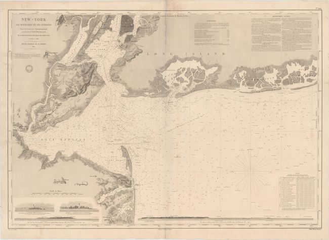
Auction 169, Lot 279
Subject: New York Bay & Bight
Depot de la Marine
New-York ses Mouillages et ses Atterages..., 1854
Size: 34.8 x 24.3 inches (88.4 x 61.7 cm)
Estimate: $1,400 - $1,700
Rare Large Chart of New York Bay and Bight
Sold for: $700
Closed on 9/12/2018
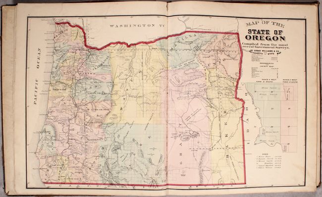
Auction 169, Lot 286
Subject: Oregon
Historical Atlas Map of Marion & Linn Counties Oregon..., 1878
Size: 14.5 x 17.6 inches (36.8 x 44.7 cm)
Estimate: $2,000 - $2,500
The First County Atlas for Oregon
Unsold
Closed on 9/12/2018
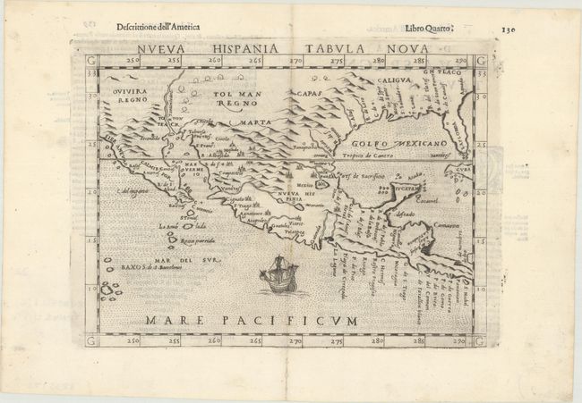
Auction 169, Lot 310
Subject: Southern United States & Mexico
Ruscelli, Girolamo
Nueva Hispania Tabula Nova, 1598
Size: 9.6 x 7.1 inches (24.4 x 18 cm)
Estimate: $1,200 - $1,500
A Foundation Map for the American Southwest
Sold for: $900
Closed on 9/12/2018
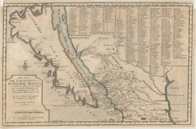
Auction 169, Lot 314
Subject: Southwestern United States & Mexico, California
Fer, Nicolas de
Cette Carte de Californie et du Nouveau Mexique, est Tiree de Celle qui a ete Envoyee par un Grand d'Espagne..., 1700
Size: 13.3 x 8.7 inches (33.8 x 22.1 cm)
Estimate: $950 - $1,200
De Fer's Important Map of the Island of California
Sold for: $650
Closed on 9/12/2018
19 lots