Showing Featured Lots(remove filter)
Filtered by Category:United States(Show All Categories)
Showing results for:Auction 162
Catalog Archive
19 lots
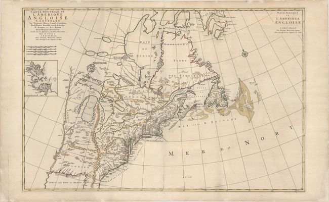
Auction 162, Lot 117
Subject: Colonial Eastern United States & Canada
Mortier, Pierre
Carte Nouvelle de l'Amerique Angloise Contenant la Virginie, Mary-Land, Caroline, Pensylvania Nouvelle Iorck, N: Iarsey N: France, et les Terres Nouvellement Decouerte..., 1700
Size: 35.9 x 23.4 inches (91.2 x 59.4 cm)
Estimate: $2,000 - $2,300
A Map Showing Fascinating Geographic Misconceptions
Sold for: $1,500
Closed on 4/26/2017
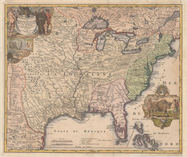
Auction 162, Lot 118
Subject: Colonial Eastern United States & Canada
Homann, Johann Baptist
Amplissimae Regionis Mississipi seu Provinciae Ludovicianae..., 1720
Size: 22.8 x 19.1 inches (57.9 x 48.5 cm)
Estimate: $2,000 - $2,300
Striking Map of Colonial America with Buffalo Vignette
Sold for: $1,300
Closed on 4/26/2017
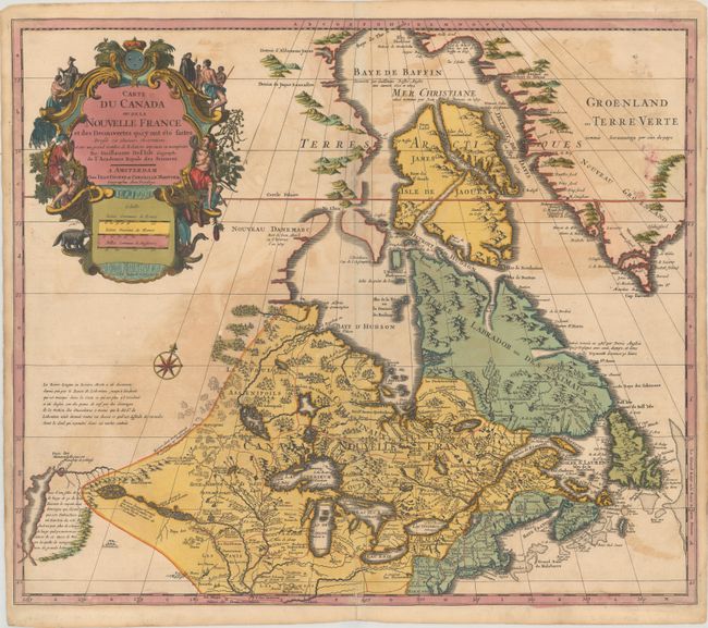
Auction 162, Lot 119
Subject: Colonial Eastern United States & Canada, Great Lakes
Delisle/Covens & Mortier
Carte du Canada ou de la Nouvelle France et des Decouvertes qui y ont ete Faites Dressee sur Plusieurs Observations et sur un Grand Nombre de Relations Imprimees ou Manuscrites, 1730
Size: 22.3 x 19.3 inches (56.6 x 49 cm)
Estimate: $900 - $1,100
One of the Most Influential Maps of Canada, the Great Lakes and Upper Midwest
Sold for: $650
Closed on 4/26/2017
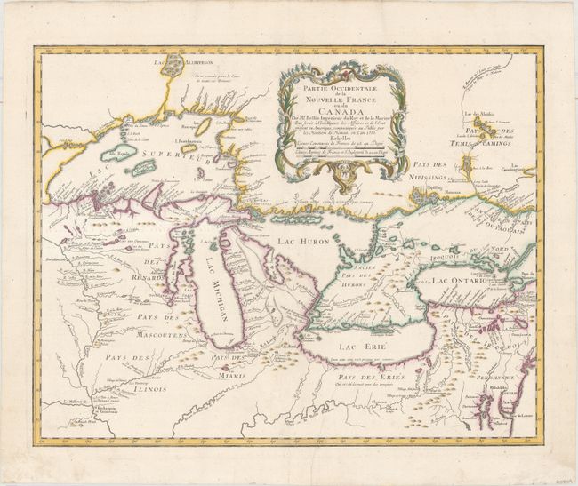
Auction 162, Lot 130
Subject: Colonial Great Lakes
Bellin/Homann Heirs
Partie Occidentale de la Nouvelle France ou du Canada par Mr. Bellin..., 1755
Size: 21.5 x 17 inches (54.6 x 43.2 cm)
Estimate: $1,800 - $2,100
Influential Map of the Great Lakes
Sold for: $975
Closed on 4/26/2017
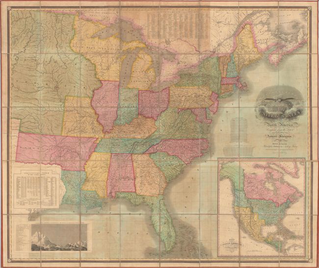
Auction 162, Lot 152
Subject: Eastern United States
Vance, David H.
Map of the United States of North America Compiled from the Latest and Most Authentic Information, 1825
Size: 61.6 x 51.8 inches (156.5 x 131.6 cm)
Estimate: $8,000 - $10,000
First Edition of Vance's Scarce, Large Map of the United States
Unsold
Closed on 4/26/2017
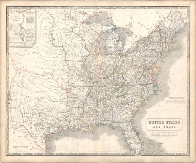
Auction 162, Lot 158
Subject: Eastern United States, Texas
Johnston, Alexander K.
United States and Texas, 1842
Size: 24.1 x 19.6 inches (61.2 x 49.8 cm)
Estimate: $1,200 - $1,400
Highly Detailed British Atlas Map Featuring the Independent Republic of Texas
Sold for: $600
Closed on 4/26/2017
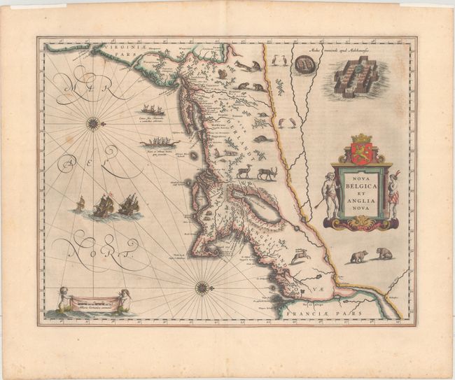
Auction 162, Lot 161
Subject: Colonial New England & Mid-Atlantic United States
Blaeu, Willem
Nova Belgica et Anglia Nova, 1635
Size: 19.9 x 15.3 inches (50.5 x 38.9 cm)
Estimate: $2,750 - $3,500
Important Map of Colonial New England and the Mid-Atlantic
Unsold
Closed on 4/26/2017
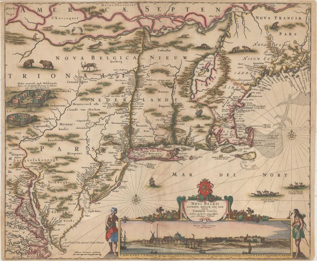
Auction 162, Lot 163
Subject: Colonial New England & Mid-Atlantic United States
Visscher, Nicolas
Novi Belgii Novaeque Angliae nec non Partis Virginiae Tabula Multis in Locis Emendata, 1682
Size: 21.8 x 18.3 inches (55.4 x 46.5 cm)
Estimate: $7,500 - $9,000
Visscher's Influential Map with Early View of New York City - Rare 3rd State Without Philadelphia
Sold for: $4,000
Closed on 4/26/2017
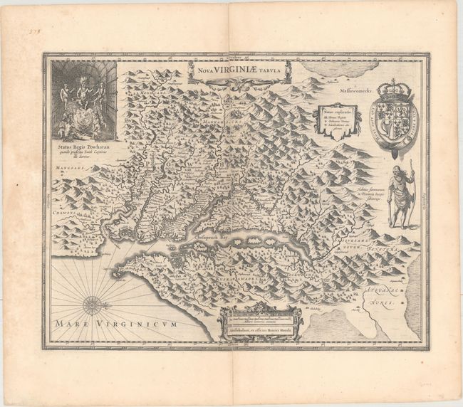
Auction 162, Lot 170
Subject: Colonial Mid-Atlantic United States
Hondius, Henricus
Nova Virginiae Tabula, 1652
Size: 19.4 x 15 inches (49.3 x 38.1 cm)
Estimate: $1,900 - $2,200
One of the Most Important 17th Century Maps of the Chesapeake Bay
Unsold
Closed on 4/26/2017
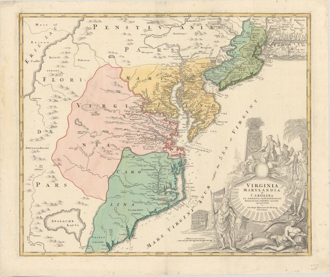
Auction 162, Lot 172
Subject: Colonial Mid-Atlantic United States
Homann, Johann Baptist
Virginia Marylandia et Carolina in America Septentrionali Britannorum Industria Excultae, 1714
Size: 23.1 x 19.3 inches (58.7 x 49 cm)
Estimate: $1,900 - $2,200
Map Created to Promote German Immigration to the New World
Sold for: $1,400
Closed on 4/26/2017
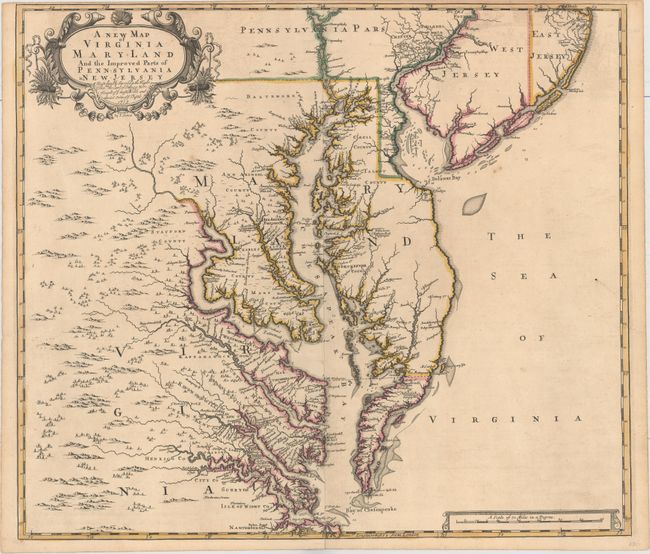
Auction 162, Lot 173
Subject: Colonial Mid-Atlantic United States
Browne/Senex
A New Map of Virginia Mary-land and the Improved Parts of Pennsylvania & New Jersey..., 1719
Size: 21.9 x 19.1 inches (55.6 x 48.5 cm)
Estimate: $4,750 - $6,000
Map of Chesapeake Bay Based on Landmark Herrman Map
Sold for: $5,500
Closed on 4/26/2017
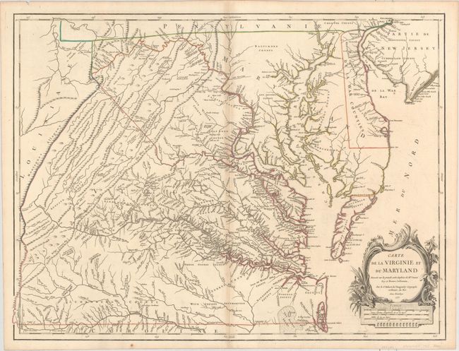
Auction 162, Lot 174
Subject: Colonial Mid-Atlantic United States
Robert de Vaugondy, Didier
Carte de la Virginie et du Maryland Dressee sur la Grande Carte Angloise de Mrs. Josue Fry et Pierre Jefferson, 1755
Size: 25.5 x 19.2 inches (64.8 x 48.8 cm)
Estimate: $2,300 - $2,750
First State of Robert de Vaugondy's Essential Map of Virginia and Maryland
Sold for: $1,500
Closed on 4/26/2017
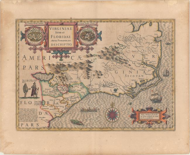
Auction 162, Lot 179
Subject: Colonial Southeast United States
Hondius, Jodocus
Virginiae Item et Floridae Americae Provinciarum, Nova Descriptio, 1619
Size: 19.3 x 13.6 inches (49 x 34.5 cm)
Estimate: $2,000 - $2,300
A Seminal Map of the Southeast and Early American Cartography - Full Original Color
Sold for: $1,200
Closed on 4/26/2017
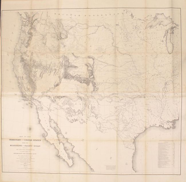
Auction 162, Lot 217
Subject: Western United States
Warren, Lieut. G. K.
Map of the Territory of the United States from the Mississippi to the Pacific Ocean Ordered by the Hon. Jeff'n Davis, Secretary of War..., 1857
Size: 46.3 x 42.3 inches (117.6 x 107.4 cm)
Estimate: $1,200 - $1,500
Warren's General Map - One of the Most Important Maps of the American West
Sold for: $1,400
Closed on 4/26/2017
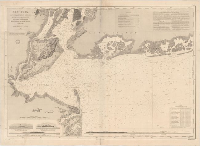
Auction 162, Lot 281
Subject: New York Bay & Bight
Depot de la Marine
New-York ses Mouillages et ses Atterages..., 1854
Size: 34.8 x 24.3 inches (88.4 x 61.7 cm)
Estimate: $2,000 - $2,300
Rare Large Chart of New York Bay and Bight
Unsold
Closed on 4/26/2017
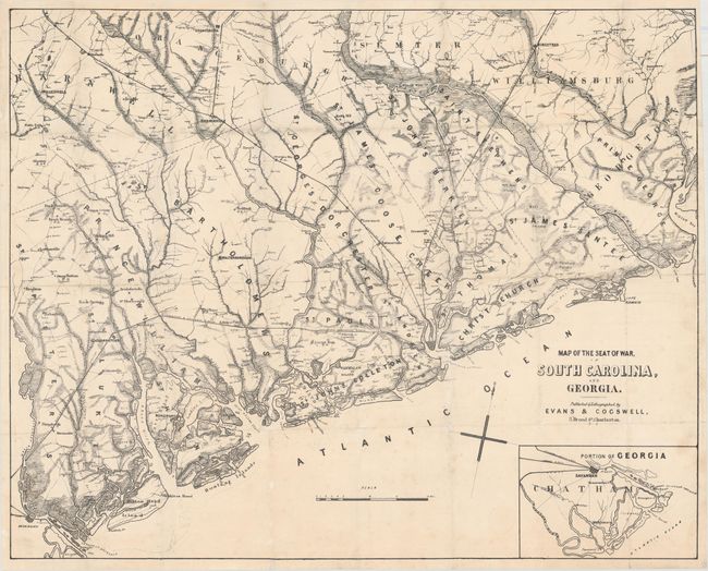
Auction 162, Lot 296
Subject: South Carolina
Map of the Seat of War, in South Carolina, and Georgia, 1861
Size: 25.6 x 20.6 inches (65 x 52.3 cm)
Estimate: $7,000 - $8,500
Rare Civil War-Era Map of South Carolina from the Confederacy's Preferred Printer
Unsold
Closed on 4/26/2017
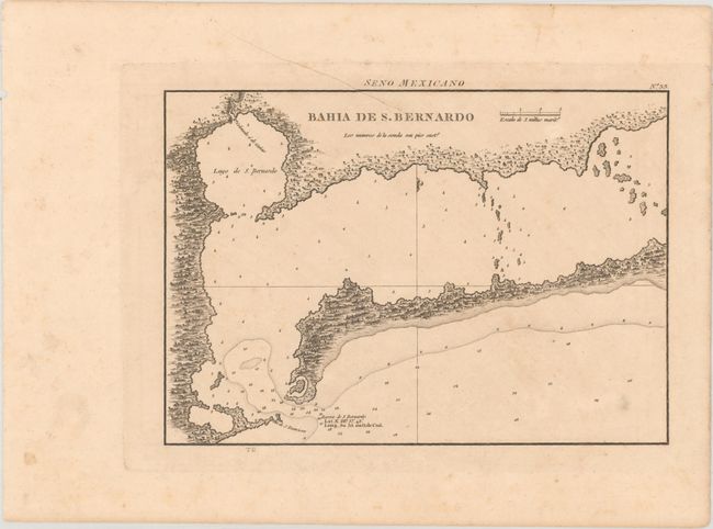
Auction 162, Lot 310
Subject: Matagorda Bay, Texas
Direccion de Hidrografia
Bahia de S. Bernardo, 1809
Size: 10.2 x 7.2 inches (25.9 x 18.3 cm)
Estimate: $700 - $850
First Engraved Map of Matagorda Bay
Unsold
Closed on 4/26/2017
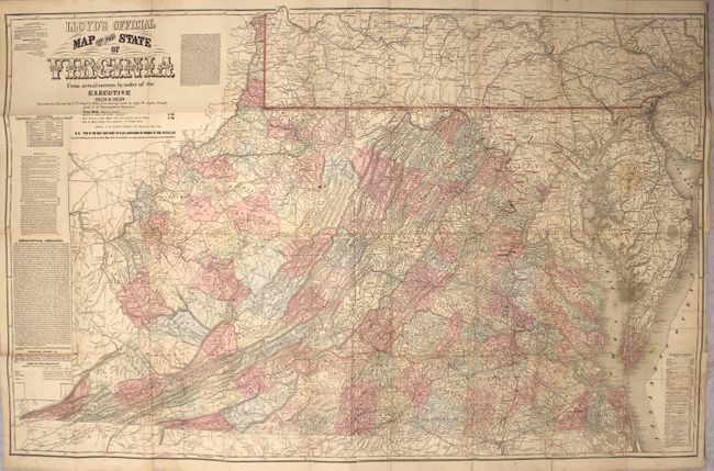
Auction 162, Lot 311
Subject: Virginia
Lloyd, James T.
Lloyd's Official Map of the State of Virginia from Actual Surveys by Order of the Executive 1828 & 1859..., 1862
Size: 47.1 x 30.3 inches (119.6 x 77 cm)
Estimate: $4,000 - $5,000
Rare London Issue of Lloyd's Civil War Map of Virginia with Racist Commentary
Unsold
Closed on 4/26/2017
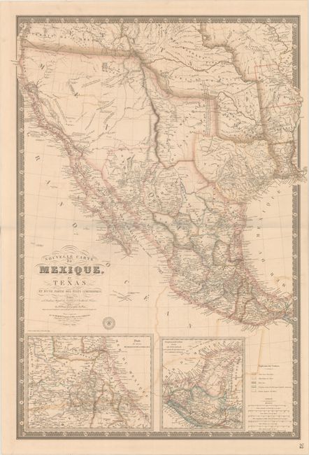
Auction 162, Lot 328
Subject: Western United States & Mexico, Texas, California
Brue, Adrien Hubert
Nouvelle Carte du Mexique, du Texas et d'une Partie des Etats Limitrophes..., 1840
Size: 25.9 x 36.6 inches (65.8 x 93 cm)
Estimate: $3,000 - $3,750
Brue's Landmark Map of the West Featuring the Republic of Texas
Unsold
Closed on 4/26/2017
19 lots