Subject: New York Bay & Bight
Period: 1854 (dated)
Publication:
Color: Black & White
Size:
34.8 x 24.3 inches
88.4 x 61.7 cm
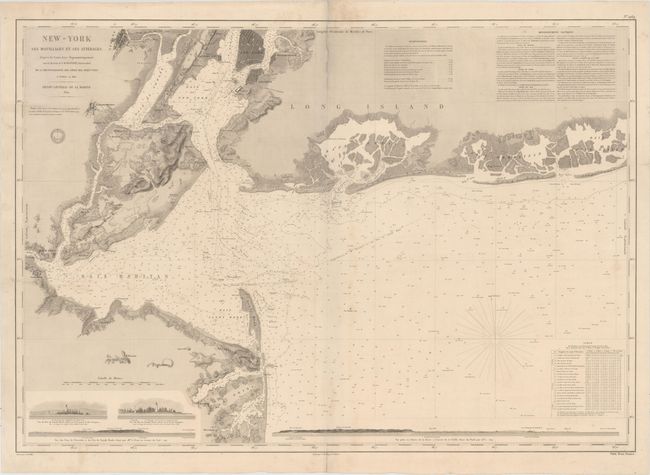
This rare oversized chart focuses on the New York Bay and Bight. It spans from Shrewsbury in Monmouth County, north to Newark, and east to South Oyster Bay and Jones Beach Island. There is fine topographical detail along the coasts, and cities such as Perth Amboy, Elizabethtown, Newark, and Jersey City, as well as boroughs/neighborhoods such as Lower Manhattan, Brooklyn, and Williamsburg, are shown in miniature plan form. The water is filled with navigational information, including soundings, bottom types, banks, currents, lighthouses, and more. Raritan, Sandy Hook, Upper New York, Jamaica, Hempstead, and South Oyster bays are among the bays identified here. Notes on the system of measurement used and navigation appear across the top, and a table at bottom right provides information about the direction and speed of the currents. Coastal profile views at the bottom show the Sandy Hook Light from two vantages, the Navesink Heights and surroundings, and a lengthy stretch from Navesink Light to South Amboy. The engraved seal of the Depot de la Marine is below the title, with the price Prix. Deux Francs appearing below the neatline at bottom right. Drawn by J.M. Hacq and V. Carre and engraved by C.E. Collin.
References:
Condition: B+
A nice impression on paper with an "Archettes" watermark and light soiling. There are archival repairs to several short centerfold separations at top and to four tears that enter image - one at right enters 1.5" and three at left enter 1", 4" and 7".