Showing Featured Lots(remove filter)
Filtered by Category:United States(Show All Categories)
Showing results for:Auction 159
Catalog Archive
25 lots
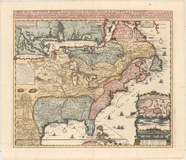
Auction 159, Lot 123
Subject: Colonial Eastern United States & Canada
Chatelain, Henry Abraham
Carte de la Nouvelle France, ou se voit le Cours des Grandes Rivieres de S. Laurens & de Mississipi Aujour d'hui S. Louis, aux Environs des-quelles se Trouvent les Etats, Pais, Nations, Peuples &c..., 1719
Size: 19.4 x 16.7 inches (49.3 x 42.4 cm)
Estimate: $2,500 - $3,000
One of the Most Informative 18th Century Maps of the French Possessions in North America
Sold for: $1,900
Closed on 9/14/2016
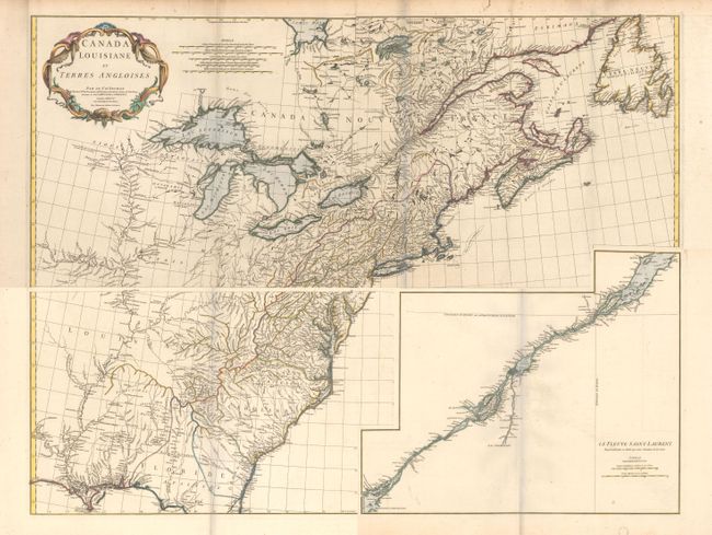
Auction 159, Lot 125
Subject: Colonial Eastern United States & Canada
Anville, Jean Baptiste Bourguignon d'
[On 4 Sheets] Canada Louisiane et Terres Angloises, 1755
Size: 44.5 x 18.8 inches (113 x 47.8 cm)
Estimate: $2,000 - $2,300
D'Anville's Spectacular Map of Eastern Seaboard
Unsold
Closed on 9/14/2016
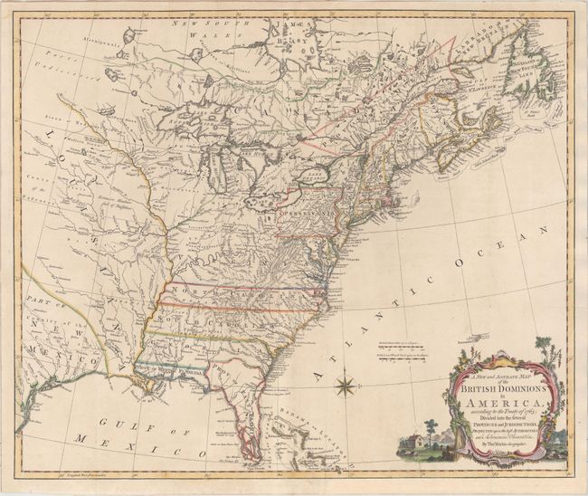
Auction 159, Lot 127
Subject: Colonial Eastern United States & Canada
Kitchin, Thomas
A New and Accurate Map of the British Dominions in America, According to the Treaty of 1763; Divided into the Several Provinces and Jurisdictions..., 1766
Size: 24.8 x 20.8 inches (63 x 52.8 cm)
Estimate: $2,200 - $2,500
Rare Map of the British Colonies Just After the French & Indian War
Sold for: $1,600
Closed on 9/14/2016
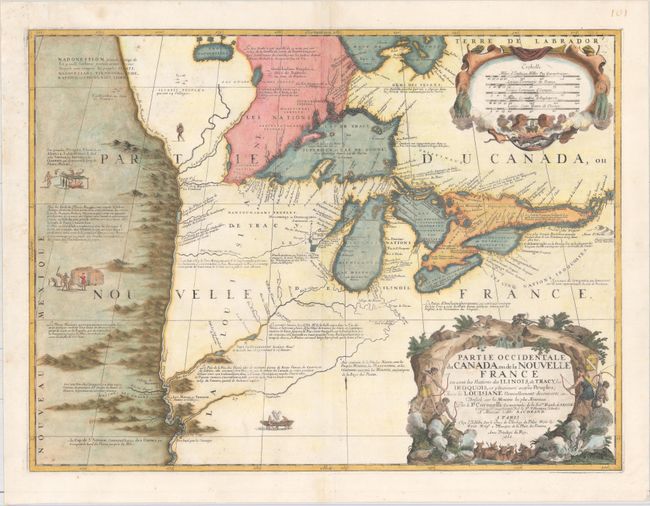
Auction 159, Lot 140
Subject: Colonial Great Lakes
Coronelli/Nolin
Partie Occidentale du Canada ou de la Nouvelle France ou Sont les Nations des Ilinois, de Tracy, les Iroquois, et Plusieurs Autres Peuples; avec la Louisiane Nouvellement Decouverte etc., 1688
Size: 23.3 x 17.4 inches (59.2 x 44.2 cm)
Estimate: $12,000 - $15,000
Third State of Coronelli's Important Map of the Great Lakes
Sold for: $11,500
Closed on 9/14/2016
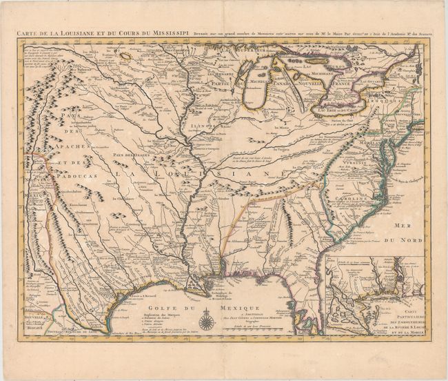
Auction 159, Lot 159
Subject: Colonial Eastern United States, Louisiana Territory
Delisle/Covens & Mortier
Carte de la Louisiane et du Cours du Mississipi Dressee sur un Grand Nombre de Memoires Entr' Autres sur ceux de Mr. le Maire, 1730
Size: 23.6 x 17.3 inches (59.9 x 43.9 cm)
Estimate: $2,750 - $3,500
Delisle's Influential Map of the Louisiana Territory
Sold for: $1,400
Closed on 9/14/2016
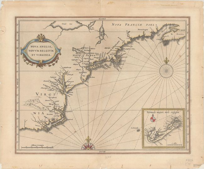
Auction 159, Lot 170
Subject: Colonial New England & Mid-Atlantic
Gerritsz/De Laet
Nova Anglia, Novum Belgium et Virginia, 1630
Size: 14.1 x 11.1 inches (35.8 x 28.2 cm)
Estimate: $5,500 - $7,000
A Map of Extreme Importance in the Cartographic Evolution of North America
Unsold
Closed on 9/14/2016
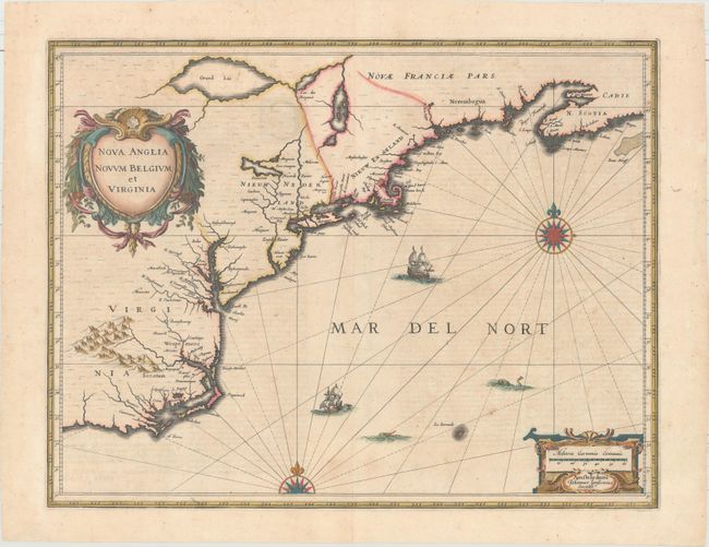
Auction 159, Lot 171
Subject: Colonial New England & Mid-Atlantic
Jansson, Jan
Nova Anglia Novum Belgium et Virginia, 1639
Size: 19.9 x 15.3 inches (50.5 x 38.9 cm)
Estimate: $1,800 - $2,100
Jansson's Influential Map of the East Coast
Unsold
Closed on 9/14/2016
Auction 159, Lot 172
Subject: Colonial New England & Mid-Atlantic United States
Visscher, Nicolas
Novi Belgii Novaeque Angliae nec non Partis Virginiae Tabula Multis in Locis Emendata, 1684
Size: 21.9 x 18.4 inches (55.6 x 46.7 cm)
Estimate: $8,000 - $9,500
Visscher's Influential Map with Early View of New York City
Unsold
Closed on 9/14/2016
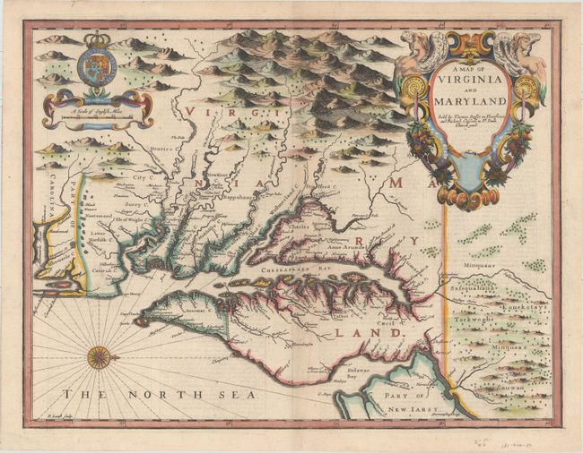
Auction 159, Lot 179
Subject: Colonial Mid-Atlantic United States
Speed/Lamb
A Map of Virginia and Maryland, 1676
Size: 19.4 x 14.9 inches (49.3 x 37.8 cm)
Estimate: $4,750 - $6,000
The First Printed Map to Draw Upon the Legendary Herrman Map of the Chesapeake Bay
Sold for: $2,900
Closed on 9/14/2016
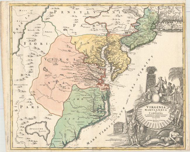
Auction 159, Lot 181
Subject: Colonial Mid-Atlantic United States
Homann, Johann Baptist
Virginia Marylandia et Carolina in America Septentrionali Britannorum Industria Excultae, 1714
Size: 22.9 x 19.3 inches (58.2 x 49 cm)
Estimate: $1,900 - $2,200
Map Created to Promote German Immigration to the New World
Unsold
Closed on 9/14/2016
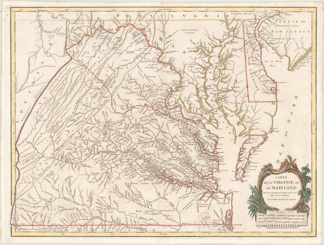
Auction 159, Lot 186
Subject: Colonial Mid-Atlantic United States
Robert de Vaugondy, Didier
Carte de la Virginie et du Maryland Dressee sur la Grande Carte Angloise de Mrs. Josue Fry et Pierre Jefferson, 1793
Size: 25.3 x 19 inches (64.3 x 48.3 cm)
Estimate: $2,400 - $3,000
An Essential Map of Virginia and Maryland
Sold for: $1,200
Closed on 9/14/2016
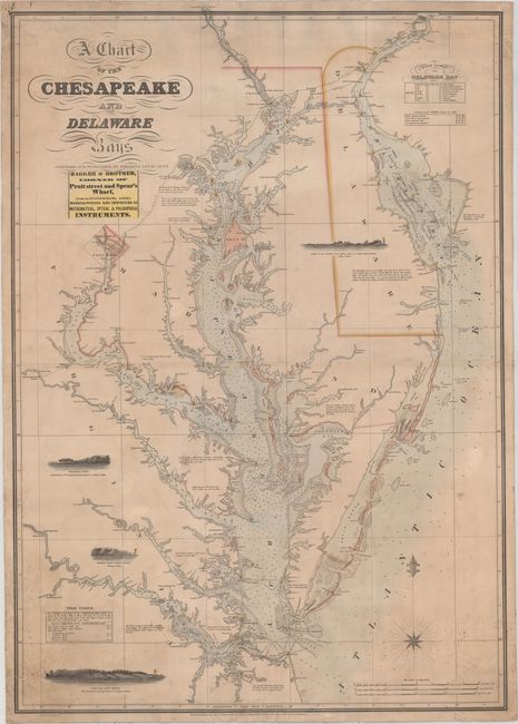
Auction 159, Lot 189
Subject: Mid-Atlantic United States, Chesapeake & Delaware Bays
Lucas, Fielding
A Chart of the Chesapeake and Delaware Bays, 1852
Size: 28.3 x 40.5 inches (71.9 x 102.9 cm)
Estimate: $6,000 - $7,500
Scarce Sea Chart of the Chesapeake and Delaware Bays
Sold for: $4,500
Closed on 9/14/2016
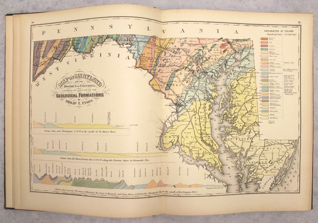
Auction 159, Lot 191
Subject: Maryland & Washington, D.C., Atlases
Walling & Gray
New Topographical Atlas of the State of Maryland and the District of Columbia. With Descriptions Historical, Scientific, and Statistical..., 1873
Size: 13.9 x 17.6 inches (35.3 x 44.7 cm)
Estimate: $1,500 - $1,800
Complete Rare Atlas of Maryland and DC
Sold for: $1,100
Closed on 9/14/2016
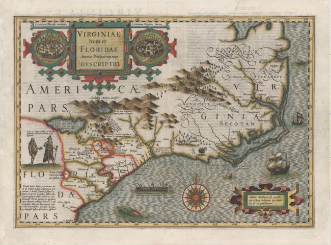
Auction 159, Lot 192
Subject: Colonial Southeastern United States
Hondius, Jodocus
Virginiae Item et Floridae Americae Provinciarum, Nova Descriptio, 1606
Size: 19 x 13.5 inches (48.3 x 34.3 cm)
Estimate: $2,200 - $2,500
A Seminal Map of the Southeast and Early American Cartography - First Edition
Sold for: $1,600
Closed on 9/14/2016
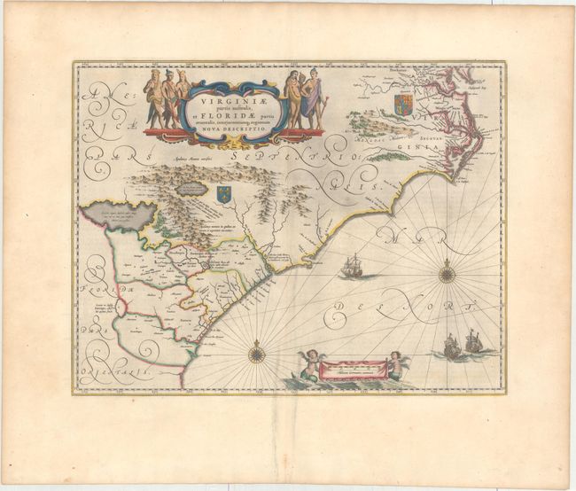
Auction 159, Lot 194
Subject: Colonial Southeastern United States
Blaeu, Willem
Virginiae Partis Australis, et Floridae Partis Orientalis, Interjacentiumq Regionum Nova Descriptio, 1663
Size: 19.9 x 15.2 inches (50.5 x 38.6 cm)
Estimate: $1,600 - $1,900
Blaeu's Decorative Map of the Southeast
Sold for: $800
Closed on 9/14/2016
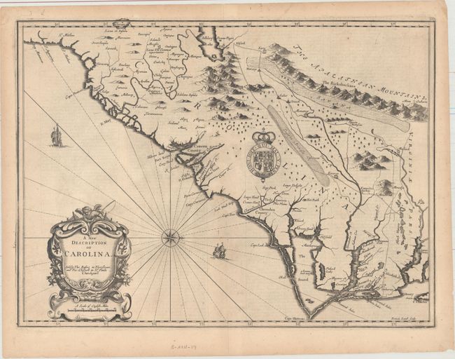
Auction 159, Lot 196
Subject: Colonial Southeastern United States
Speed/Lamb
A New Description of Carolina, 1676
Size: 20.1 x 14.9 inches (51.1 x 37.8 cm)
Estimate: $4,000 - $5,000
Speed's Map of the Carolinas Based Upon the Lords Proprietor's Map
Sold for: $2,200
Closed on 9/14/2016
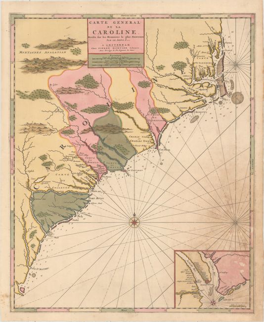
Auction 159, Lot 197
Subject: Colonial Southeast United States
Mortier, Pierre
Carte General de la Caroline. Dresse sur les Memoires le Plus Nouveaux par le Sieua S..., 1700
Size: 18.3 x 22.4 inches (46.5 x 56.9 cm)
Estimate: $2,000 - $2,300
The First Map of the Carolinas Published Outside of England
Unsold
Closed on 9/14/2016
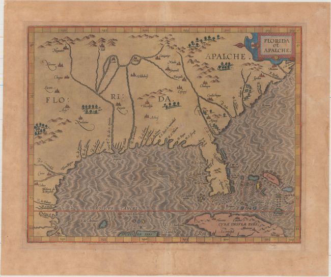
Auction 159, Lot 202
Subject: Southern United States
Wytfliet, Cornelis
Florida et Apalche, 1597
Size: 11.3 x 9.1 inches (28.7 x 23.1 cm)
Estimate: $1,600 - $2,000
One of the Earliest Obtainable Maps of Florida & the Southeast
Sold for: $1,400
Closed on 9/14/2016
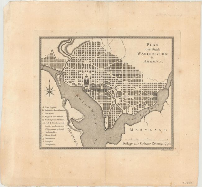
Auction 159, Lot 246
Subject: Washington, D.C.
Plan der Stadt Washington in America, 1796
Size: 9.9 x 8.4 inches (25.1 x 21.3 cm)
Estimate: $2,400 - $3,000
Extremely Rare Austrian Version of the Thackara & Vallance DC Map
Unsold
Closed on 9/14/2016
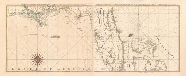
Auction 159, Lot 250
Subject: Florida
Le Rouge, George Louis
[Lot of 2] Carte de la Floride Occidentale et Louisiane [and] La Peninsule et Golfe de la Floride ou Canal de Bahama avec les Isles de Bahama, 1777
Size: 24.2 x 18.9 inches (61.5 x 48 cm)
Estimate: $1,800 - $2,100
Important Map of Florida and Its Coastlines
Unsold
Closed on 9/14/2016
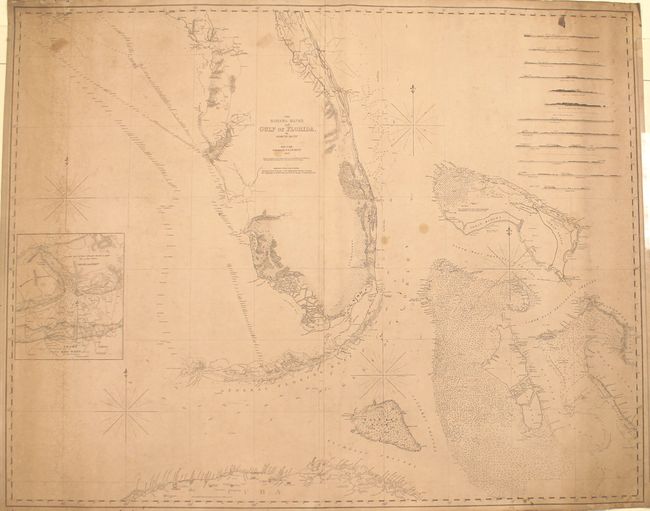
Auction 159, Lot 252
Subject: Florida, Bahamas, Cuba
Blunt, Edmund
The Bahama Banks and Gulf of Florida, 1847
Size: 48.7 x 38.7 inches (123.7 x 98.3 cm)
Estimate: $1,600 - $2,000
Impressive Blueback Chart of the Florida Keys and Dry Tortugas
Unsold
Closed on 9/14/2016
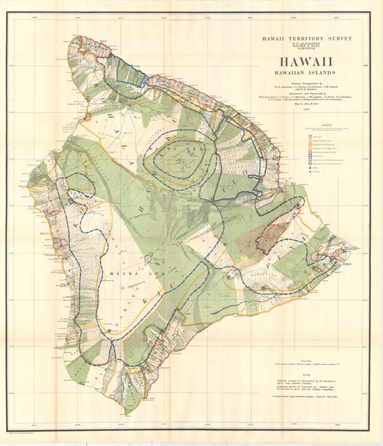
Auction 159, Lot 265
Subject: Hawaii
U.S. Government
[Lot of 8] Hawaii Hawaiian Islands [and] Kauai... [and] Lanai... [and] Maui County... [and] Maui... [and] Molokai [and] Niihau... [and] Oahu... , 1897-1906
Size: See Description
Estimate: $1,000 - $1,300
A Great Set of Hawaii Territory Maps
Sold for: $2,200
Closed on 9/14/2016
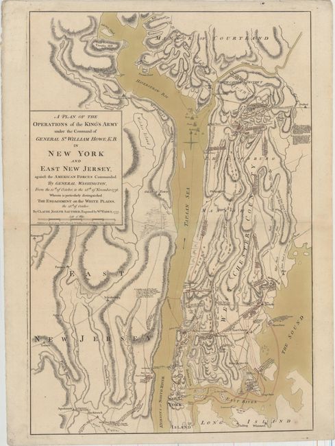
Auction 159, Lot 281
Subject: Colonial New York, Revolutionary War
Sauthier/Faden
A Plan of the Operations of the King's Army Under the Command of General Sr. William Howe, K.B. in New York and East New Jersey..., 1777
Size: 19.3 x 28.5 inches (49 x 72.4 cm)
Estimate: $11,000 - $14,000
Important Revolutionary War Map of the Battle of White Plains
Unsold
Closed on 9/14/2016
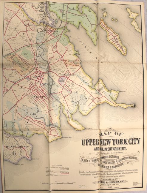
Auction 159, Lot 287
Subject: New York City, New York
[On 4 Sheets] Map of Upper New York City and Adjacent Country. Showing the City Above 125th Street. The City of Yonkers and Townships of East Chester, West Chester Pelham and New Rochelle. And a Portion of Mamaroneck, 1889
Size: 8.5 x 11 inches (21.6 x 27.9 cm)
Estimate: $1,500 - $1,800
Impressive 4-Sheet Map of Upper New York City and Westchester County
Sold for: $1,000
Closed on 9/14/2016
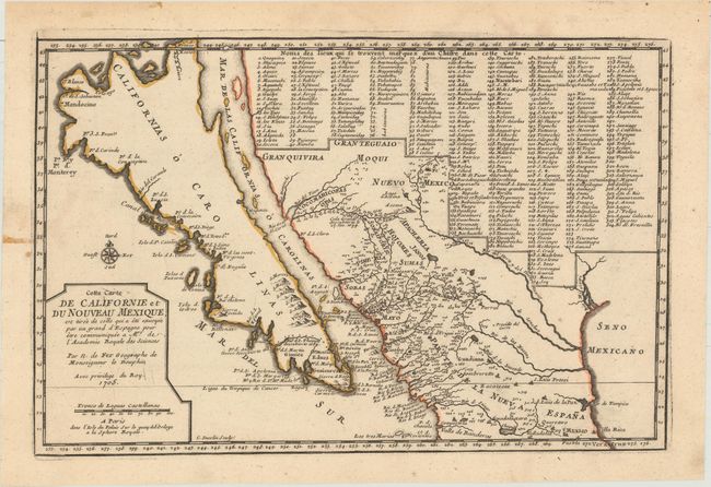
Auction 159, Lot 313
Subject: Southwestern United States & Mexico, California
Fer, Nicolas de
Cette Carte de Californie et du Nouveau Mexique, est Tiree de Celle qui a ete Envoyee par un Grand d'Espagne pour Etre Communiquee a Mrs. de l'Academie Royale des Sciences, 1705
Size: 13.4 x 8.9 inches (34 x 22.6 cm)
Estimate: $1,400 - $1,700
De Fer's Important Map of the Island of California
Unsold
Closed on 9/14/2016
25 lots