Subject: Colonial New England & Mid-Atlantic
Period: 1630 (circa)
Publication: Nieuwe Wereldt ofte Beschrijvinghe van West-Indien…
Color: Hand Color
Size:
14.1 x 11.1 inches
35.8 x 28.2 cm
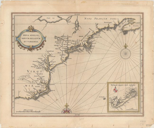
This scarce map places the Dutch settlements in their geographic context just five years after the founding of New Amsterdam; being the first printed map to use the names Manbattes (Manhattan), N. Amsterdam (New York), and Massachusets (Massachusetts). It is also the earliest acquirable map with an insular Manhattan, and to show any of the Great Lakes (Grand Lac). The depiction of the coastal area between Chesapeake Bay and Cape Cod is by far the most accurate of the period. The map also includes an early and well-detailed inset of Bermuda. Decorated with a strapwork title cartouche and two compass roses.
The map is the work of Hessel Gerritsz, one of the truly important Dutch cartographers of the 17th century. Gerritsz was cartographer to the Dutch East India Company and Johannes de Laet was the director of the Dutch West India Company. De Laet was a principal player in the founding of New Netherland and owned a large tract of land in the area of Albany. Both had access to surveys, documentation and information from Dutch colonists, which provided the basis for this fine early map.
References: Augustyn & Cohen pp. 26-7; Burden #231; McCorkle #630.1; Schwartz & Ehrenberg, pl. 57, p. 103.
Condition: B+
A crisp impression on watermarked paper with a couple of small spots. Backed with Japanese tissue to repair some tiny worm holes, centerfold separations that just pass the neatline at top and bottom, and several tiny chips and tears along the edges of the sheet.