Showing Featured Lots(remove filter)
Filtered by Category:United States(Show All Categories)
Showing results for:Auction 156
Catalog Archive
28 lots
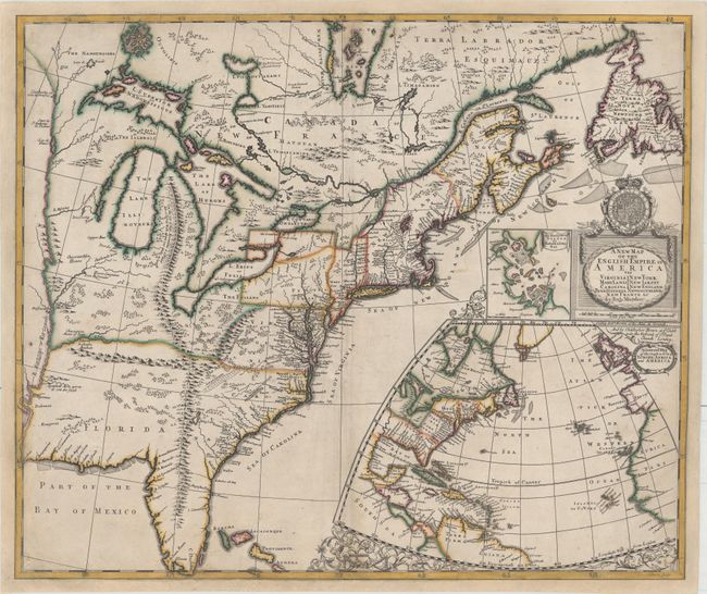
Auction 156, Lot 122
Subject: Colonial Eastern United States & Canada
Morden, Robert
A New Map of the English Empire in America viz Virginia Maryland Carolina Pennsylvania New York New Iarsey New England Newfoundland New France &c., 1695
Size: 23.4 x 19.8 inches (59.4 x 50.3 cm)
Estimate: $14,000 - $16,000
First State of Morden's Rare Map of the American Colonies
Unsold
Closed on 2/17/2016
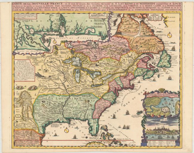
Auction 156, Lot 123
Subject: Colonial Eastern United States & Canada
Chatelain, Henry Abraham
Carte de la Nouvelle France, ou se voit le Cours des Grandes Rivieres de S. Laurens & de Mississipi Aujour d'hui S. Louis, aux Environs des-quelles se Trouvent les Etats, Pais, Nations, Peuples &c..., 1719
Size: 19.1 x 16.6 inches (48.5 x 42.2 cm)
Estimate: $2,200 - $2,500
One of the Most Informative 18th Century Maps of the French Possessions in North America
Sold for: $2,500
Closed on 2/17/2016
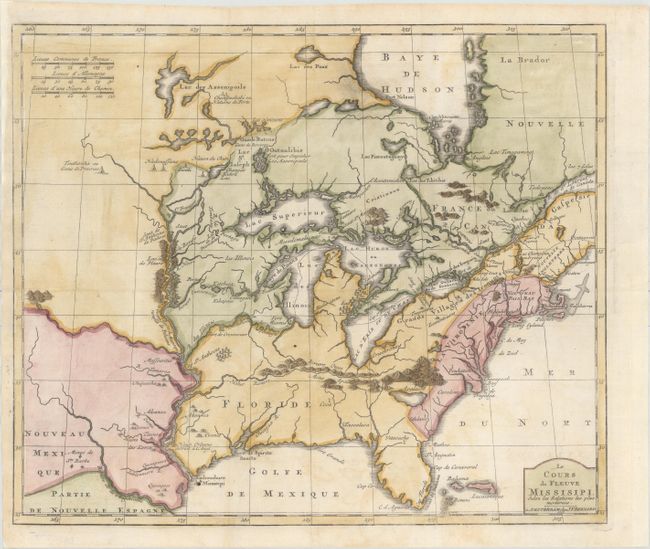
Auction 156, Lot 124
Subject: Colonial Eastern United States & Canada, Great Lakes
Bernard, Jean Frederic
Le Cours du Fleuve Missisipi Selon les Relations les Plus Modernes, 1737
Size: 17.3 x 14.7 inches (43.9 x 37.3 cm)
Estimate: $1,600 - $1,900
Scarce and Desirable Early Hennepin Variant
Sold for: $1,400
Closed on 2/17/2016
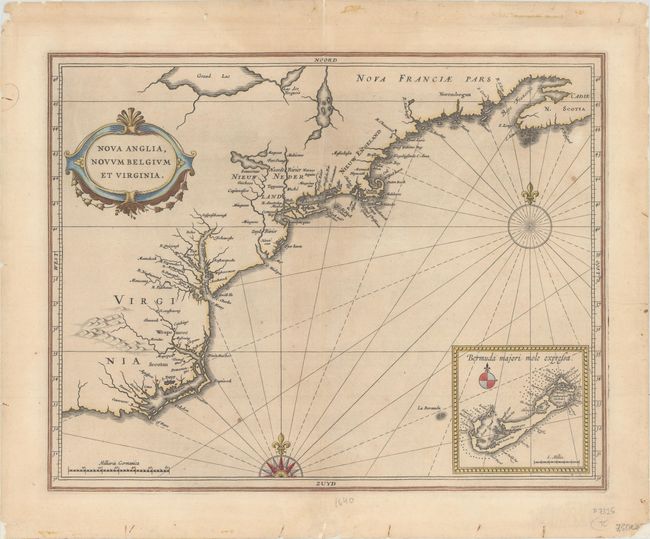
Auction 156, Lot 171
Subject: Colonial New England & Mid-Atlantic
Gerritsz/De Laet
Nova Anglia, Novum Belgium et Virginia, 1630
Size: 14.1 x 11.1 inches (35.8 x 28.2 cm)
Estimate: $5,500 - $7,000
A Map of Extreme Importance in the Cartographic Evolution of North America
Unsold
Closed on 2/17/2016
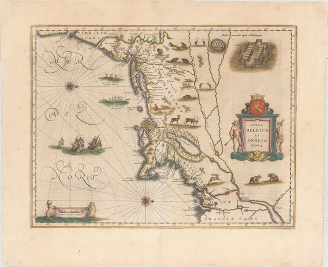
Auction 156, Lot 172
Subject: Colonial New England & Mid-Atlantic
Blaeu, Willem
Nova Belgica et Anglia Nova, 1642
Size: 19.9 x 15.4 inches (50.5 x 39.1 cm)
Estimate: $3,000 - $3,750
Important Map of Colonial New England and the Mid-Atlantic - Full Original Color
Sold for: $2,200
Closed on 2/17/2016
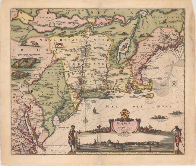
Auction 156, Lot 174
Subject: Colonial New England & Mid-Atlantic
Visscher, Nicolas
Novi Belgii Novaeque Angliae nec non Partis Virginiae Tabula Multis in Locis Emendata, 1684
Size: 21.8 x 18.3 inches (55.4 x 46.5 cm)
Estimate: $8,000 - $9,500
Visscher's Influential Map with Early View of New York City
Sold for: $5,000
Closed on 2/17/2016
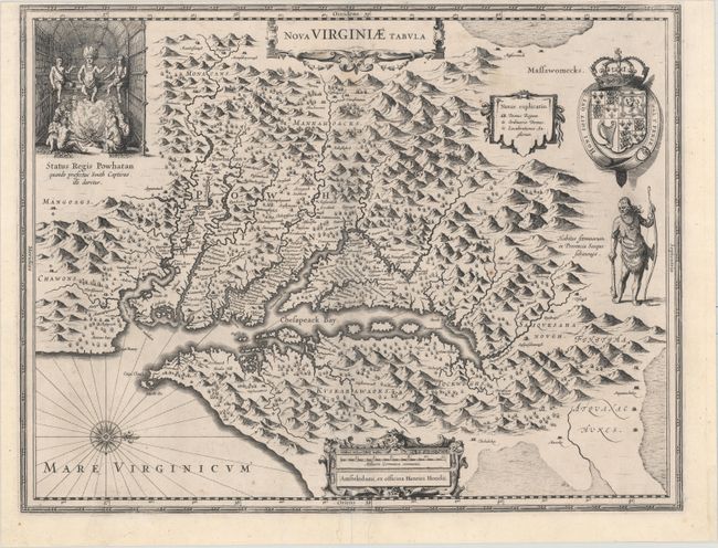
Auction 156, Lot 183
Subject: Colonial Mid-Atlantic United States
Hondius, Henricus
Nova Virginiae Tabula, 1630
Size: 19.6 x 15.1 inches (49.8 x 38.4 cm)
Estimate: $2,000 - $2,300
One of the Most Important 17th Century Maps of the Chesapeake Bay
Sold for: $1,100
Closed on 2/17/2016
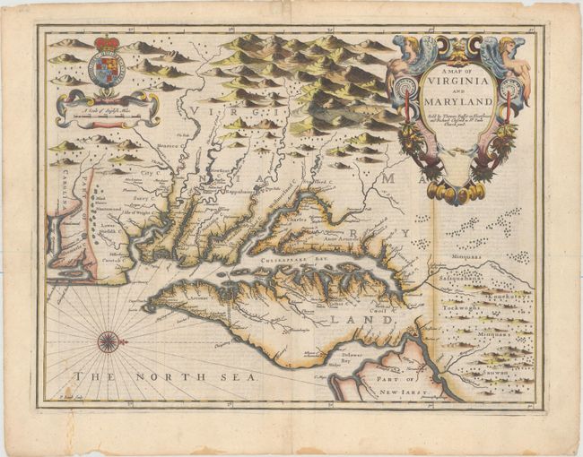
Auction 156, Lot 186
Subject: Colonial Mid-Atlantic United States
Speed/Lamb
A Map of Virginia and Maryland, 1676
Size: 19.4 x 14.9 inches (49.3 x 37.8 cm)
Estimate: $4,000 - $5,000
The First Printed Map to Draw Upon the Legendary Herrman Map of the Chesapeake Bay
Unsold
Closed on 2/17/2016
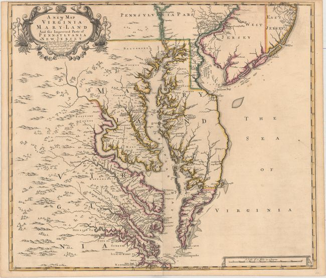
Auction 156, Lot 188
Subject: Colonial Mid-Atlantic United States
Browne/Senex
A New Map of Virginia Mary-land and the Improved Parts of Pennsylvania & New Jersey..., 1719
Size: 21.9 x 19.1 inches (55.6 x 48.5 cm)
Estimate: $5,500 - $6,500
Map of Chesapeake Bay Based on Landmark Herrman Map
Unsold
Closed on 2/17/2016
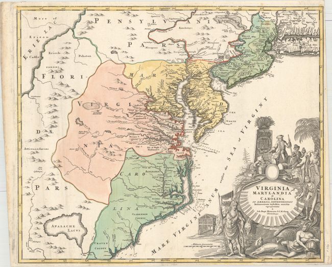
Auction 156, Lot 189
Subject: Colonial Mid-Atlantic United States
Homann, Johann Baptist
Virginia Marylandia et Carolina in America Septentrionali Britannorum Industria Excultae, 1714
Size: 22.9 x 19.3 inches (58.2 x 49 cm)
Estimate: $1,900 - $2,200
Map Created to Promote German Immigration to the New World
Unsold
Closed on 2/17/2016
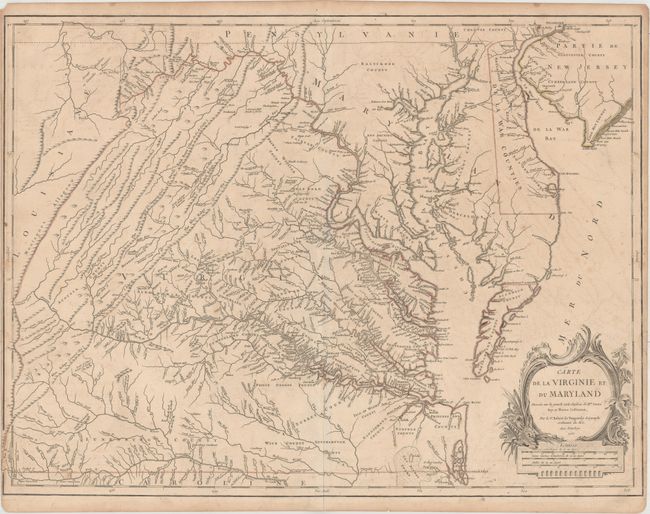
Auction 156, Lot 191
Subject: Colonial Mid-Atlantic United States
Robert de Vaugondy, Didier
Carte de la Virginie et du Maryland Dressee sur la Grande Carte Angloise de Mrs. Josue Fry et Pierre Jefferson..., 1755
Size: 25.4 x 19.1 inches (64.5 x 48.5 cm)
Estimate: $2,200 - $2,500
An Essential Map of Virginia and Maryland
Unsold
Closed on 2/17/2016
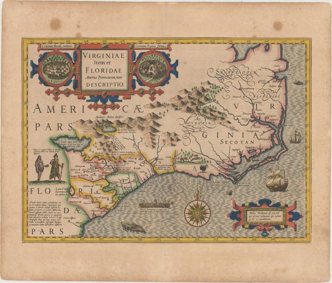
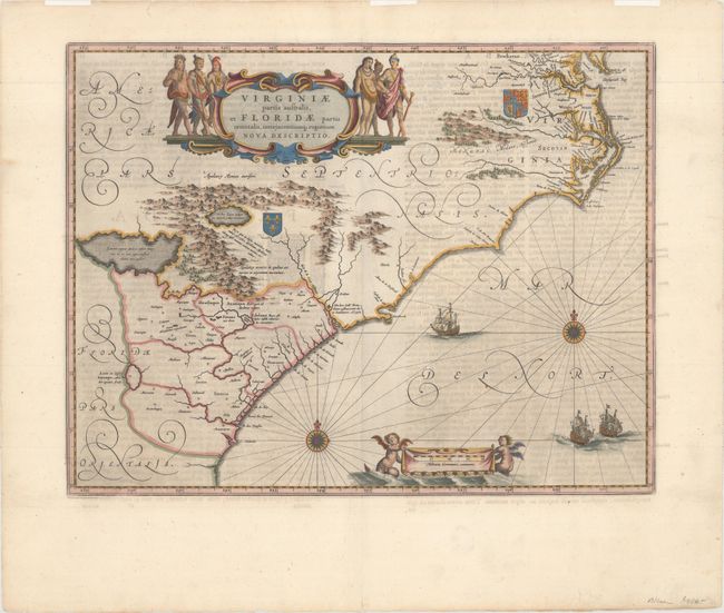
Auction 156, Lot 198
Subject: Colonial Southeast United States
Hondius, Jodocus
Virginiae Item et Floridae Americae Provinciarum, Nova Descriptio, 1628
Size: 19.3 x 13.6 inches (49 x 34.5 cm)
Estimate: $2,200 - $3,000
A Seminal Map of the Southeast and Early American Cartography
Sold for: $1,500
Closed on 2/17/2016
Auction 156, Lot 199
Subject: Colonial Southeast United States
Blaeu, Willem
Virginiae Partis Australis, et Floridae Partis Orientalis, Interjacentiumq Regionum Nova Descriptio, 1662
Size: 19.6 x 15.2 inches (49.8 x 38.6 cm)
Estimate: $1,600 - $1,900
Blaeu's Decorative Map of the Southeast
Sold for: $1,200
Closed on 2/17/2016
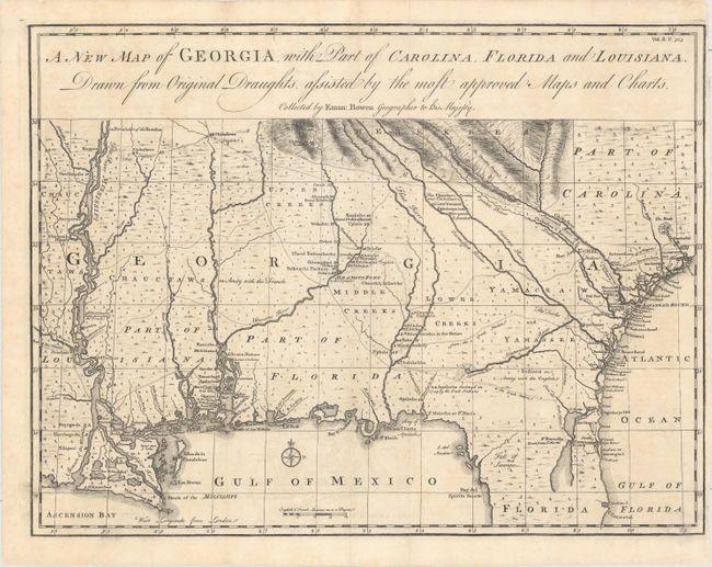
Auction 156, Lot 202
Subject: Colonial Southeast United States
Bowen, Emanuel
A New Map of Georgia, with Part of Carolina, Florida and Louisiana. Drawn from Original Draughts, Assisted by the Most Approved Maps and Charts, 1763
Size: 18.8 x 14.3 inches (47.8 x 36.3 cm)
Estimate: $3,250 - $4,000
Important Map of the Georgia Colony
Sold for: $2,200
Closed on 2/17/2016
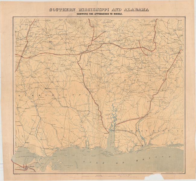
Auction 156, Lot 212
Subject: Southern United States, Civil War
U.S. Coast Survey
Southern Mississippi and Alabama Showing the Approaches to Mobile, 1863
Size: 24.5 x 22.3 inches (62.2 x 56.6 cm)
Estimate: $1,000 - $1,500
First Edition of this Rare Civil War Map
Unsold
Closed on 2/17/2016
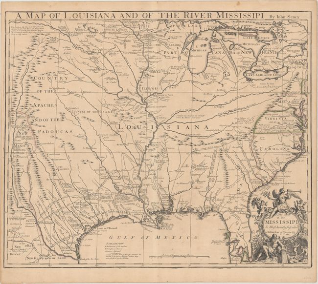
Auction 156, Lot 214
Subject: South Central United States, Louisiana
Senex, John
A Map of Louisiana and of the River Mississipi, 1721
Size: 22.7 x 19.1 inches (57.7 x 48.5 cm)
Estimate: $2,750 - $3,500
Important Map of Colonial Louisiana and the Mississippi River
Sold for: $1,700
Closed on 2/17/2016
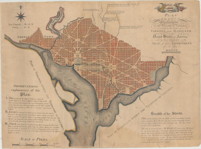
Auction 156, Lot 256
Subject: Washington, D.C.
Thackara, James
Plan of the City of Washington in the Territory of Columbia, Ceded by the States of Virginia and Maryland to the United States of America, and by Them Established as the Seat of Their Government After the Year MDCCC, 1792
Size: 26.4 x 20.3 inches (67.1 x 51.6 cm)
Estimate: $13,000 - $16,000
The First "Official" Plan of Washington
Sold for: $9,000
Closed on 2/17/2016
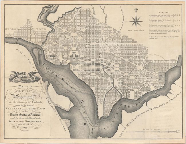
Auction 156, Lot 257
Subject: Washington, D.C.
Russell, John C.
Plan of the City of Washington, in the Territory of Columbia, Ceded by the States of Virginia and Maryland to the United States of America, and by Them Established as the Seat of Their Government, After the Year 1800, 1795
Size: 20.9 x 15.9 inches (53.1 x 40.4 cm)
Estimate: $2,750 - $3,500
Rare, Early Large Format Map of Washington D.C.
Sold for: $1,500
Closed on 2/17/2016
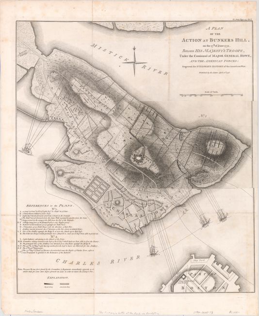
Auction 156, Lot 276
Subject: Boston, Massachusetts
Stedman, Charles
A Plan of the Action at Bunkers Hill, on the 17th of June 1775. Between His Majesty's Troops, Under the Command of Major General Howe, and the American Forces: Engraved for Stedman's History of the American War, 1793
Size: 16.9 x 19.2 inches (42.9 x 48.8 cm)
Estimate: $1,200 - $1,500
The Most Precise and Detailed Plan of the Battle of Bunker Hill
Sold for: $900
Closed on 2/17/2016
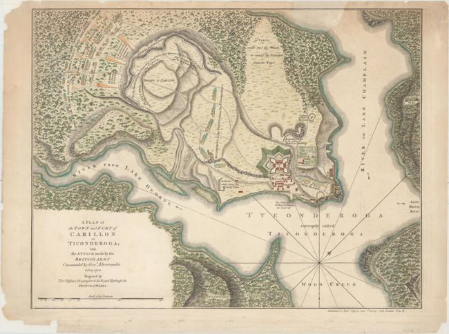
Auction 156, Lot 290
Subject: Ticonderoga, New York
Jefferys, Thomas
A Plan of the Town and Fort of Carillon at Ticonderoga; with the Attack Made by the British Army Commanded by Genl. Abercrombie, 8 July 1758, 1768
Size: 18.9 x 14.6 inches (48 x 37.1 cm)
Estimate: $1,000 - $1,300
Scarce Map of the Battle of Carillon
Sold for: $750
Closed on 2/17/2016
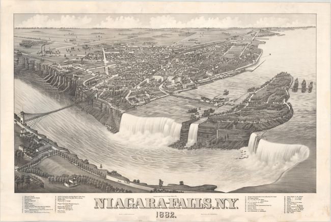
Auction 156, Lot 291
Subject: Niagara Falls, New York
Stoner, J. J.
Niagara-Falls, N.Y., 1882
Size: 29 x 17.3 inches (73.7 x 43.9 cm)
Estimate: $1,600 - $1,900
Stunning Bird's-Eye View of Niagara Falls
Sold for: $1,200
Closed on 2/17/2016
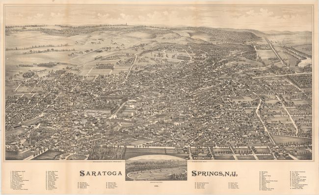
Auction 156, Lot 294
Subject: Saratoga Springs, New York
Burleigh
Saratoga Springs, N.Y., 1888
Size: 33.3 x 19.1 inches (84.6 x 48.5 cm)
Estimate: $1,800 - $2,300
Rare View of Famous Spa Town in New York
Unsold
Closed on 2/17/2016
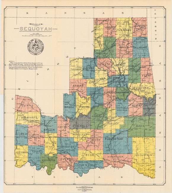
Auction 156, Lot 298
Subject: Oklahoma
U.S. Government
State of Sequoyah, 1905
Size: 14.9 x 16.3 inches (37.8 x 41.4 cm)
Estimate: $1,200 - $1,500
Scarce Map Featuring the Proposed State of Sequoyah
Sold for: $1,600
Closed on 2/17/2016
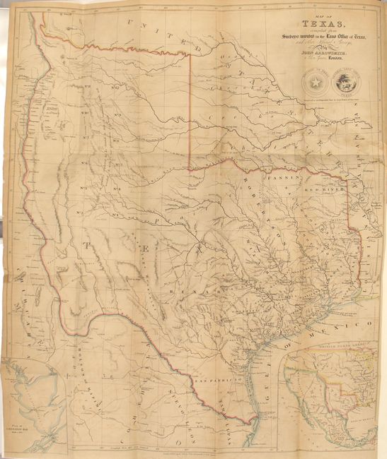
Auction 156, Lot 305
Subject: Texas
Arrowsmith, John
Map of Texas, Compiled from Surveys Recorded in the Land Office of Texas, and other Official Surveys [bound in] Texas: The Rise, Progress, and Prospects of the Republic of Texas, 1841
Size: 19.8 x 24 inches (50.3 x 61 cm)
Estimate: $18,000 - $20,000
Arrowsmith's Important Map of the Republic of Texas with Kennedy's Book
Unsold
Closed on 2/17/2016
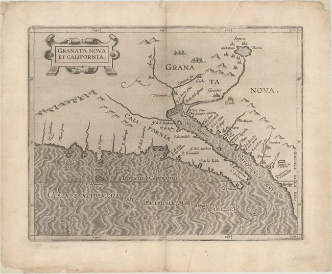
Auction 156, Lot 329
Subject: Southwestern United States & Mexico
Wytfliet, Cornelis
Granata Nova et California, 1597
Size: 11.4 x 9 inches (29 x 22.9 cm)
Estimate: $2,750 - $3,500
First Printed Map to Focus on California and the Southwest
Sold for: $2,000
Closed on 2/17/2016
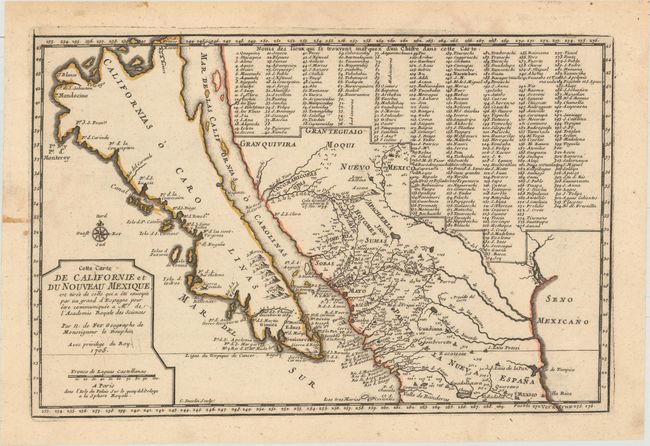
Auction 156, Lot 330
Subject: Southwestern United States & Mexico, California
Fer, Nicolas de
Cette Carte de Californie et du Nouveau Mexique, est Tiree de Celle qui a ete Envoyee par un Grand d'Espagne pour Etre Communiquee a Mrs. de l'Academie Royale des Sciences, 1705
Size: 13.4 x 8.9 inches (34 x 22.6 cm)
Estimate: $1,400 - $1,700
De Fer's Important Map of the Island of California
Unsold
Closed on 2/17/2016
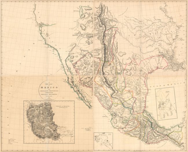
Auction 156, Lot 335
Subject: Western United States & Mexico
Arrowsmith, Aaron, Sr.
[On 4 Sheets] A New Map of Mexico and Adjacent Provinces Compiled from Original Documents, 1815
Size: 31.1 x 25.4 inches (79 x 64.5 cm)
Estimate: $9,000 - $11,000
Arrowsmith's Cornerstone Map of Texas and the Southwest
Sold for: $4,500
Closed on 2/17/2016
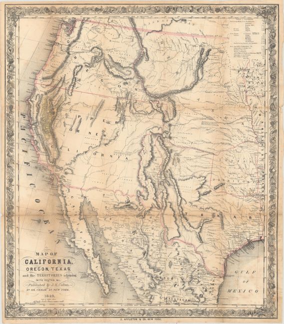
Auction 156, Lot 337
Subject: Western United States & Mexico
Colton, Joseph Hutchins
Map of California, Oregon, Texas, and the Territories Adjoining with Routes &c., 1849
Size: 18.1 x 20.8 inches (46 x 52.8 cm)
Estimate: $1,400 - $1,700
Colton's Rare Map Depicting the Gold Region of California
Sold for: $1,000
Closed on 2/17/2016
28 lots