Showing Featured Lots(remove filter)
Filtered by Category:United States(Show All Categories)
Showing results for:Auction 154
Catalog Archive
18 lots
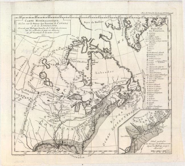
Auction 154, Lot 97
Subject: Colonial Eastern United States & Canada
Guettard, Jean Etienne
Carte Mineralogique, ou l'on voit la Nature des Terreins du Canada et de la Louisiane..., 1752
Size: 12.1 x 10.9 inches (30.7 x 27.7 cm)
Estimate: $1,200 - $1,500
First Geological Map of North America
Sold for: $900
Closed on 9/16/2015
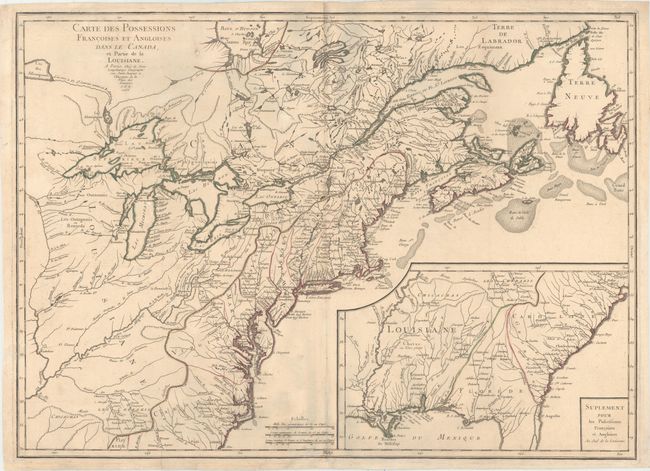
Auction 154, Lot 98
Subject: Colonial Eastern United States & Canada
Longchamp, S. G. (Sieur)
Carte des Possessions Francoises et Angloises dans le Canada, et Partie de la Louisiane, 1756
Size: 30 x 21.6 inches (76.2 x 54.9 cm)
Estimate: $1,600 - $1,900
First State of Longchamp's Map of the Theater of the French and Indian War
Sold for: $1,400
Closed on 9/16/2015
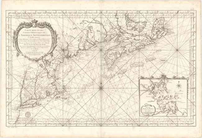
Auction 154, Lot 107
Subject: Colonial Northeastern United States & Canada
Bellin, Jacques Nicolas
Carte Reduite des Costes Orientales de l'Amerique Septentrionale 1re. Feuille Contenant l'Isle Royale, l'Accadie, la Bay Francoise, la Nouvelle Angleterre et la Nouvelle Yorc..., 1757
Size: 34.9 x 21.6 inches (88.6 x 54.9 cm)
Estimate: $2,400 - $3,000
Scarce Large-Scale Chart of the Coast of New England
Unsold
Closed on 9/16/2015
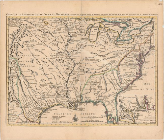
Auction 154, Lot 122
Subject: Colonial Eastern United States, Louisiana Territory
Delisle/Covens & Mortier
Carte de la Louisiane et du Cours du Mississipi Dressee sur un Grand Nombre de Memoires Entr' Autres sur Ceux de Mr. le Maire..., 1730
Size: 23.6 x 17.3 inches (59.9 x 43.9 cm)
Estimate: $2,750 - $3,500
Delisle's Influential Map of the Louisiana Territory
Unsold
Closed on 9/16/2015
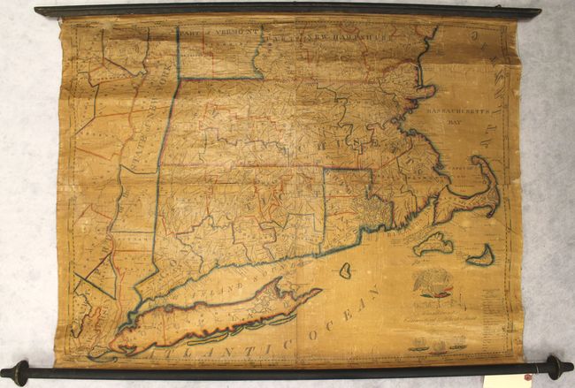
Auction 154, Lot 136
Subject: New England - United States
Ruggles, Edward
A Map of Massachusetts Connecticut and Rhodeisland..., 1824
Size: 36.3 x 28.7 inches (92.2 x 72.9 cm)
Estimate: $1,500 - $2,000
Ruggles' Rare Map of Southern New England
Sold for: $750
Closed on 9/16/2015
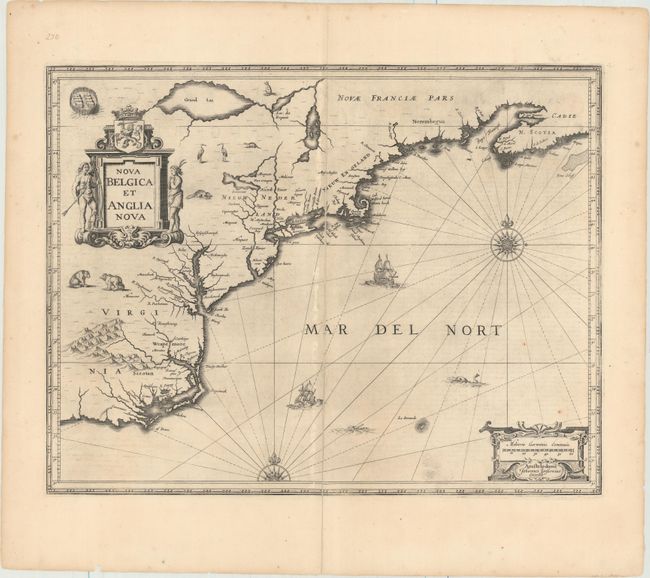
Auction 154, Lot 137
Subject: Colonial New England & Mid-Atlantic United States
Jansson, Jan
Nova Belgica et Anglia Nova, 1652
Size: 19.8 x 15.3 inches (50.3 x 38.9 cm)
Estimate: $1,600 - $1,900
Jansson's Influential Map of the East Coast
Sold for: $950
Closed on 9/16/2015
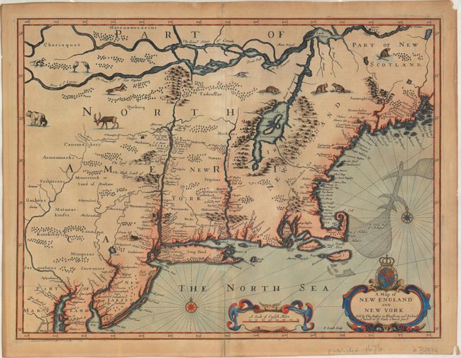
Auction 154, Lot 139
Subject: Colonial New England & Mid-Atlantic United States
Speed/Lamb
A Map of New England and New York, 1676
Size: 19.7 x 15 inches (50 x 38.1 cm)
Estimate: $4,500 - $5,500
"Speed" Map of New England
Sold for: $2,500
Closed on 9/16/2015
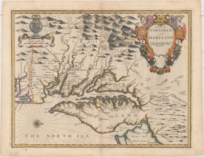
Auction 154, Lot 142
Subject: Colonial Mid-Atlantic United States
Speed/Lamb
A Map of Virginia and Maryland, 1676
Size: 19.4 x 14.9 inches (49.3 x 37.8 cm)
Estimate: $5,000 - $6,000
The First Printed Map to Draw Upon the Legendary Herrman Map of the Chesapeake Bay
Unsold
Closed on 9/16/2015
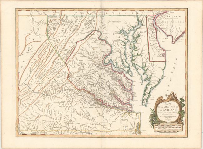
Auction 154, Lot 144
Subject: Colonial Mid-Atlantic United States
Robert de Vaugondy, Didier
Carte de la Virginie et du Maryland Dressee sur la Grande Carte Angloise de Mrs. Josue Fry et Pierre Jefferson..., 1755
Size: 25.5 x 19.1 inches (64.8 x 48.5 cm)
Estimate: $2,750 - $3,500
An Essential Map of Virginia and Maryland
Sold for: $1,700
Closed on 9/16/2015
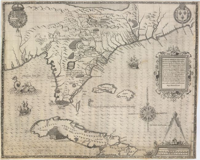
Auction 154, Lot 154
Subject: Colonial Southeast, Florida and Cuba
Bry, Theodore de
Floridae Americae Provinciae Recens & Exactissima Descriptio Auctore Iacobo le Moyne..., 1591
Size: 17.9 x 14.5 inches (45.5 x 36.8 cm)
Estimate: $9,500 - $12,000
De Bry's Influential Map of Colonial North America
Sold for: $5,000
Closed on 9/16/2015
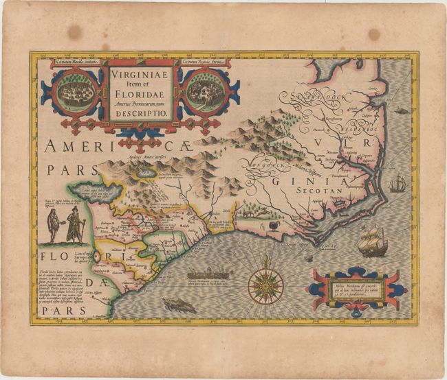
Auction 154, Lot 155
Subject: Colonial Southeast United States
Hondius, Jodocus
Virginiae Item et Floridae Americae Provinciarum, Nova Descriptio, 1628
Size: 19.3 x 13.6 inches (49 x 34.5 cm)
Estimate: $2,200 - $3,000
A Seminal Map of the Southeast and Early American Cartography
Unsold
Closed on 9/16/2015
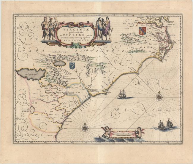
Auction 154, Lot 156
Subject: Colonial Southeast United States
Blaeu, Willem
Virginiae Partis Australis, et Floridae Partis Orientalis, Interjacentiumq Regionum Nova Descriptio, 1640
Size: 19.7 x 15.2 inches (50 x 38.6 cm)
Estimate: $1,600 - $2,000
Blaeu's Decorative Map of the Southeast
Sold for: $850
Closed on 9/16/2015
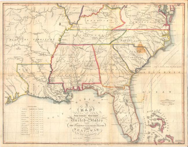
Auction 154, Lot 165
Subject: Southern United States
Melish, John
A Map of the Southern Section of the United States Including the Floridas & Bahama Islands Shewing the Seat of War, in That Department, 1813
Size: 20.9 x 16.4 inches (53.1 x 41.7 cm)
Estimate: $1,600 - $2,000
Melish's Rare Map of the Southern United States
Sold for: $1,200
Closed on 9/16/2015
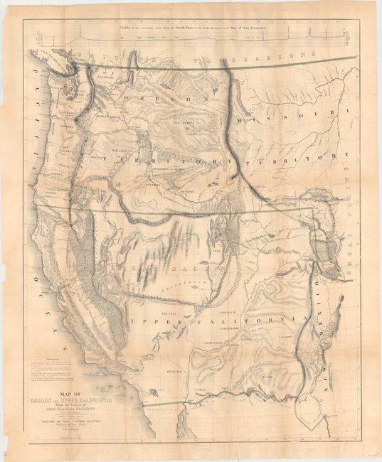
Auction 154, Lot 178
Subject: Western United States
Fremont/Preuss
Map of Oregon and Upper California from the Surveys of John Charles Fremont and Other Authorities, 1848
Size: 26.5 x 33 inches (67.3 x 83.8 cm)
Estimate: $1,500 - $1,800
Fremont's Large Map of the American West
Sold for: $1,700
Closed on 9/16/2015
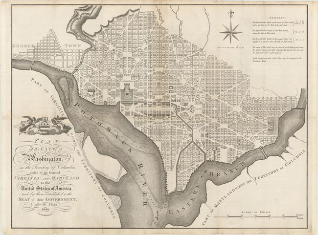
Auction 154, Lot 196
Subject: Washington, D.C.
Russell, John C.
Plan of the City of Washington, in the Territory of Columbia, Ceded by the States of Virginia and Maryland to the United States of America, and by Them Established as the Seat of Their Government, After the Year 1800, 1795
Size: 20.9 x 15.9 inches (53.1 x 40.4 cm)
Estimate: $2,400 - $3,000
Rare, Early Large Format Map of Washington D.C.
Sold for: $1,800
Closed on 9/16/2015
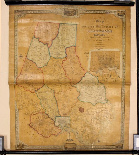
Auction 154, Lot 223
Subject: Baltimore, Maryland
[Lot of 2] Map of the City and County of Baltimore, Maryland, from Original Surveys [and] Plan of Baltimore & Vicinity Showing the Proposed Routes for Bringing Water from the Jone's and Gwynn's Falls & the Patapsco River..., 1851-53
Size: See Description
Estimate: $1,500 - $1,800
Scarce Wall Maps of Baltimore, Maryland
Sold for: $1,000
Closed on 9/16/2015
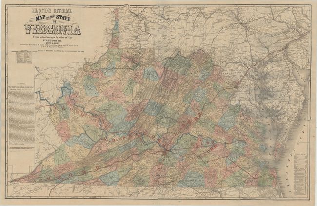
Auction 154, Lot 280
Subject: Virginia
Lloyd, James T.
Lloyd's Official Map of the State of Virginia From Actual Surveys by Order of the Executive 1828 & 1859..., 1862
Size: 47.3 x 30.4 inches (120.1 x 77.2 cm)
Estimate: $3,000 - $4,000
Extremely Rare Promotional Map with Railroad Overprint
Unsold
Closed on 9/16/2015
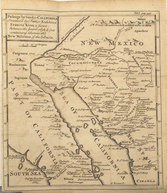
Auction 154, Lot 294
Subject: Southwestern United States & Mexico
Kino, Eusebio Francisco, SJ
Passage by Land to California Discovered by Father Eusebius Francis Kino a Jesuit; Between the Years 1698, & 1701: Containing Likewise the New Missions of the Jesuits [Bound in] Travels of the Jesuits, 1743
Size: 8 x 9.2 inches (20.3 x 23.4 cm)
Estimate: $1,000 - $1,300
Father Kino's Important Map of California
Sold for: $850
Closed on 9/16/2015
18 lots