Showing Featured Lots(remove filter)
Filtered by Category:United States(Show All Categories)
Showing results for:Auction 150
Catalog Archive
15 lots
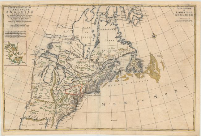
Auction 150, Lot 127
Subject: Colonial Eastern United States & Canada
Mortier, Pierre
Carte Nouvelle de l'Amerique Angloise Contenant la Virginie, Mary-Land, Caroline, Pensylvania, Nouvelle Iorck, N: Iarsey N: France, et les Terres Nouvellement Decouerte..., 1700
Size: 36 x 23.5 inches (91.4 x 59.7 cm)
Estimate: $2,500 - $3,250
A Map Showing Fascinating Geographic Misconceptions
Unsold
Closed on 9/17/2014
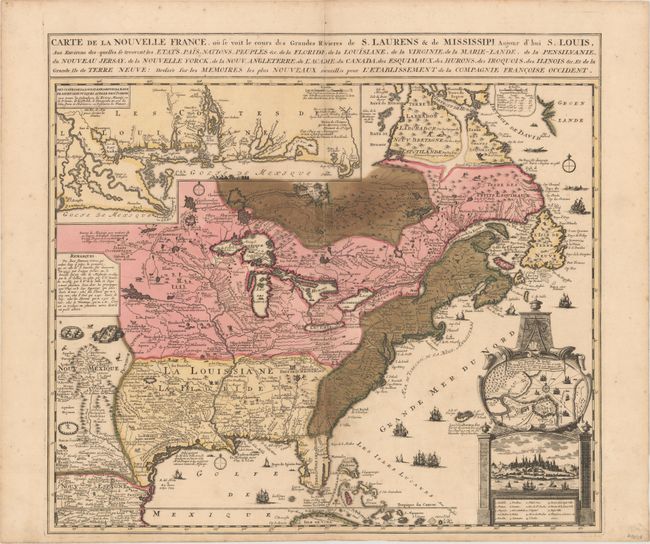
Auction 150, Lot 128
Subject: Colonial Eastern United States & Canada
Fer, Nicolas de
Carte de la Nouvelle France, ou se voit le cours des Grandes Rivieres de S. Laurens & de Mississipi, Aujour d'hui S. Louis…, 1719
Size: 21.7 x 19.6 inches (55.1 x 49.8 cm)
Estimate: $1,600 - $1,900
Striking Map of French Colonial Possessions
Sold for: $1,900
Closed on 9/17/2014
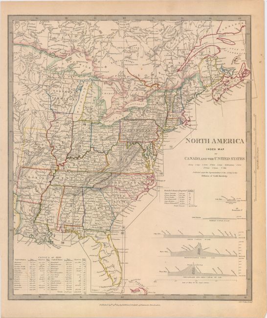
Auction 150, Lot 132
Subject: Eastern United States & Canada
SDUK Society for the Diffusion of Useful Knowledge
[Lot of 15 - North America], 1832-34
Size: 12 x 15 inches (30.5 x 38.1 cm)
Estimate: $1,500 - $2,000
Matching Set of North America SDUK Maps
Sold for: $800
Closed on 9/17/2014
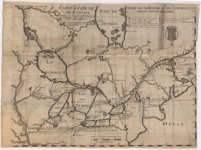
Auction 150, Lot 133
Subject: Colonial Northeastern United States & Canada, Great Lakes
Lahontan, Louis Armand, Baron de
Carte Generale de Canada. Dediee au Roy de Danemark par Son Tres Humble et Tres Obeissant et Tres Fidele Serviteur Lahontan, 1705
Size: 21.5 x 16.6 inches (54.6 x 42.2 cm)
Estimate: $2,000 - $2,400
Lahontan's Map of Canada and the Great Lakes
Sold for: $1,200
Closed on 9/17/2014
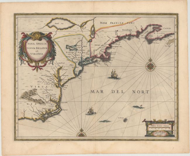
Auction 150, Lot 165
Subject: Colonial New England & Mid-Atlantic United States
Jansson, Jan
Nova Anglia Novum Belgium et Virginia, 1638
Size: 19.8 x 15.3 inches (50.3 x 38.9 cm)
Estimate: $1,600 - $1,900
Jansson's Influential Map of the East Coast
Sold for: $1,400
Closed on 9/17/2014
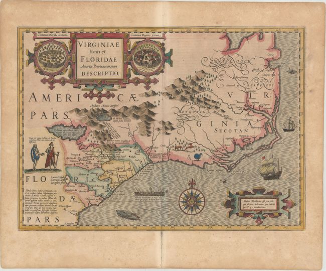
Auction 150, Lot 174
Subject: Colonial Southeast United States
Hondius, Jodocus
Virginiae Item et Floridae Americae Provinciarum, Nova Descriptio, 1623
Size: 19.2 x 13.6 inches (48.8 x 34.5 cm)
Estimate: $2,750 - $3,500
A Seminal Map of the Southeast and Early American Cartography
Unsold
Closed on 9/17/2014
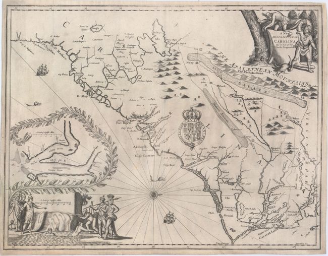
Auction 150, Lot 176
Subject: Colonial Southeast United States
Moxon/Ogilby
A New Discription of Carolina by Order of the Lords Proprietors, 1673
Size: 21.3 x 16.3 inches (54.1 x 41.4 cm)
Estimate: $12,000 - $15,000
Ogilby's Scarce and Influential First Lords Proprietors Map
Unsold
Closed on 9/17/2014
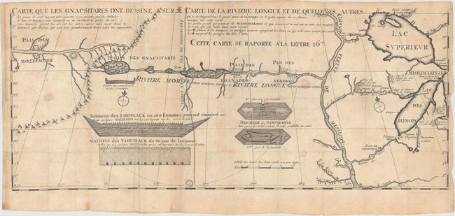
Auction 150, Lot 195
Subject: Colonial Central United States, River Longue
Lahontan, Louis Armand, Baron de
Carte que les Gnacsitares ont Dessine sur ... Carte de la Riviere Longue et de Quelques Autres qui se Dechargent dans le Grand Fleuve Missisipi …, 1703
Size: 26.1 x 11 inches (66.3 x 27.9 cm)
Estimate: $1,400 - $1,700
First Edition of Lahontan's Influential Map Depicting "Riviere Longue"
Sold for: $1,200
Closed on 9/17/2014
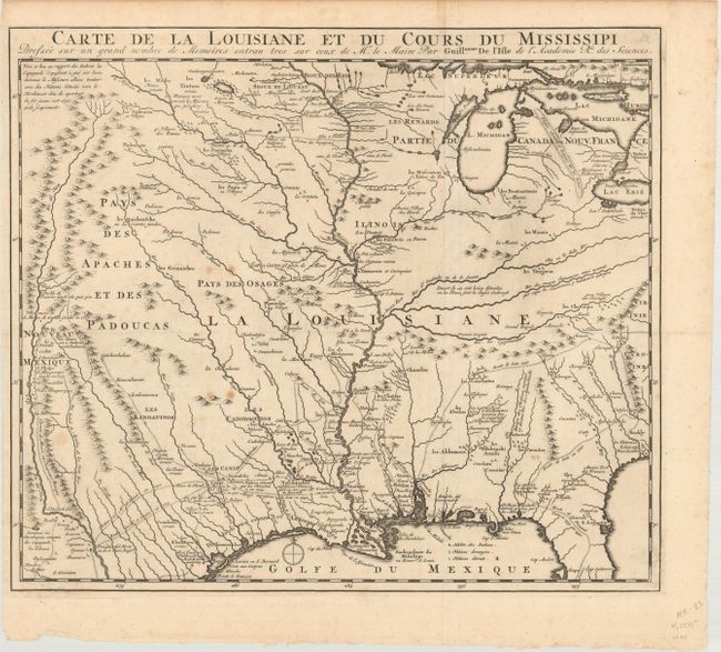
Auction 150, Lot 196
Subject: Colonial Central United States, Louisiana Territory
Delisle, Guillaume
Carte de la Louisiane et du Cours du Mississipi Dressee sur un Grand Nombre de Memoires Entrau Tres sur Ceux de Mr. le Maire, 1720
Size: 16.1 x 14 inches (40.9 x 35.6 cm)
Estimate: $1,600 - $1,900
Reduced-Size Edition of Delisle's Influential Map of the Louisiana Territory
Unsold
Closed on 9/17/2014
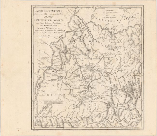
Auction 150, Lot 235
Subject: Kentucky
Filson, John
Carte de Kentucke, d'Apres les Observations Actuelles; Dediee a l'Honorable Congres des Etas-Unis de l'Amerique et a Son Excellence George Washington..., 1785
Size: 12.4 x 13.7 inches (31.5 x 34.8 cm)
Estimate: $2,500 - $3,250
The First Map of Kentucky
Unsold
Closed on 9/17/2014

Auction 150, Lot 245
Subject: Boston, Massachusetts
Stedman, Charles
A Plan of the Action at Bunkers Hill, on the 17th of June 1775. Between His Majesty's Troops, Under the Command of Major General Howe, and the American Forces: Engraved for Stedman's History of the American War, 1793
Size: 16.7 x 18.9 inches (42.4 x 48 cm)
Estimate: $1,000 - $1,300
The Most Precise and Detailed Plan of the Battle of Bunker Hill
Sold for: $1,100
Closed on 9/17/2014
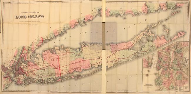
Auction 150, Lot 267
Subject: Long Island, New York
Colton, G.W. & C.B.
Colton's New Map of Long Island, 1886
Size: 63.9 x 30.2 inches (162.3 x 76.7 cm)
Estimate: $4,500 - $5,500
Monumental Map of Long Island in Mint Condition
Unsold
Closed on 9/17/2014
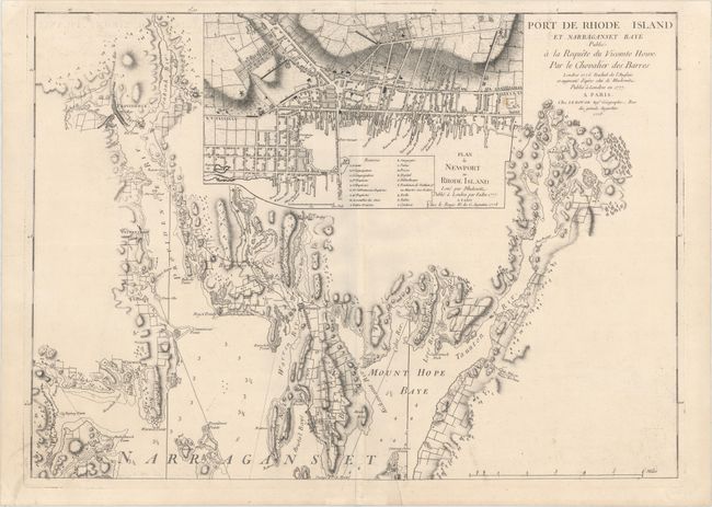
Auction 150, Lot 281
Subject: Narragansett Bay, Rhode Island
Le Rouge, George Louis
Port de Rhode Island et Narraganset Baye Publie a la Requete du Vicomte Howe par le Chevalier des Barres..., 1778
Size: 27.6 x 19.8 inches (70.1 x 50.3 cm)
Estimate: $1,500 - $1,800
Le Rouge's Impressive Chart of Narragansett Bay, RI
Sold for: $550
Closed on 9/17/2014
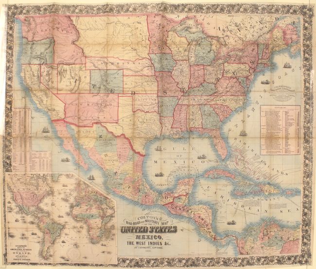
Auction 150, Lot 298
Subject: United States, Mexico & Central America
Colton, Joseph Hutchins
Colton's Rail-Road and Military Map of the United States Mexico, the West Indies &c., 1861
Size: 38.7 x 32.3 inches (98.3 x 82 cm)
Estimate: $1,200 - $1,500
Rare 1861 Colton Issue
Sold for: $750
Closed on 9/17/2014
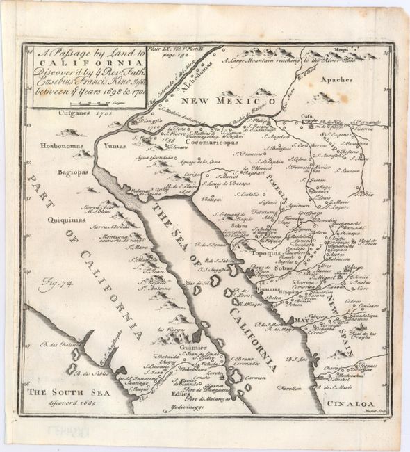
Auction 150, Lot 310
Subject: Southwestern United States & Mexico
Kino, Eusebio Francisco, SJ
A Passage by Land to California Discover'd by ye Rev. Fathr. Eusebius Francis Kino Jesuite Between ye Year 1698 & 1701, 1721
Size: 7.8 x 7.8 inches (19.8 x 19.8 cm)
Estimate: $1,000 - $1,300
Father Kino's Important Map of California
Sold for: $550
Closed on 9/17/2014
15 lots