Showing Featured Lots(remove filter)
Filtered by Category:United States(Show All Categories)
Showing results for:Auction 140
Catalog Archive
17 lots
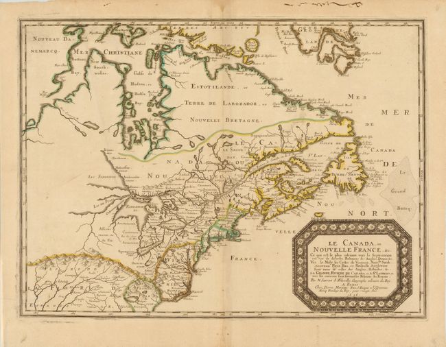
Auction 140, Lot 109
Subject: Colonial United States and Canada - Great Lakes
Sanson, Nicolas
Le Canada, ou Nouvelle France, &c., 1656
Size: 21.5 x 15.8 inches (54.6 x 40.1 cm)
Estimate: $4,750 - $6,000
Keystone Map for Great Lakes Collections
Sold for: $3,000
Closed on 5/23/2012
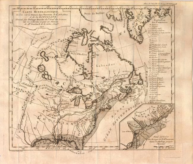
Auction 140, Lot 112
Subject: Colonial United States and Canada, Switzerland and Geology
Guettard, Jean Etienne
Carte Mineralogique, ou l'on voit la Nature des Terreins de Canada et de la Louisiane, Dressee par Philippe Buache…1752 [and] Carte Mineralogique de la Suisse par Philippe Buache pour servir aux recherches et pour un Memoire de Mr. Guettard en 1572, 1761
Size: 12 x 10.5 inches (30.5 x 26.7 cm)
Estimate: $1,300 - $1,800
Unsold
Closed on 5/23/2012
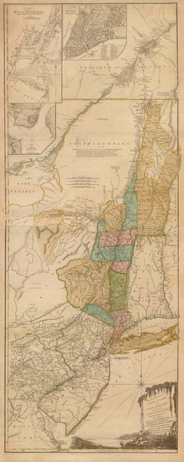
Auction 140, Lot 117
Subject: Colonial Northeast and Quebec
Sayer & Bennett
The Provinces of New York, and New Jersey; with Part of Pensilvania, and the Province of Quebec. Drawn by Major Holland…, 1776
Size: 20.5 x 53 inches (52.1 x 134.6 cm)
Estimate: $5,500 - $6,500
Thomas Jefferys' Important Revolutionary War Period Map
Unsold
Closed on 5/23/2012
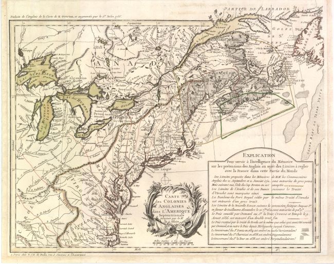
Auction 140, Lot 123
Subject: Eastern Canada & United States
Poilly, N.J.B.
Carte des Colonies Anglaises dans l'Amerique Septentrionale Terminee par la Re. Ohio, 1756
Size: 18.3 x 14.5 inches (46.5 x 36.8 cm)
Estimate: $2,500 - $3,500
An Important French Map Illustrating the Theater of the French and Indian War
Sold for: $1,800
Closed on 5/23/2012
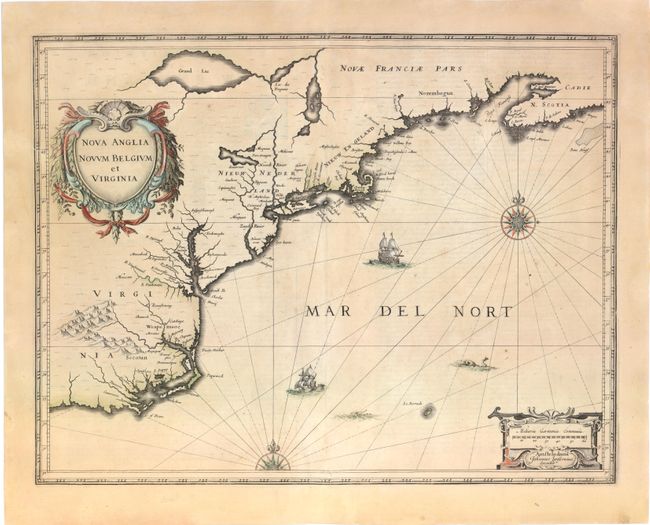
Auction 140, Lot 152
Subject: Colonial New England and Mid-Atlantic
Jansson, Jan
Nova Anglia Novum Belgium et Virginia, 1636
Size: 20 x 15.3 inches (50.8 x 38.9 cm)
Estimate: $1,700 - $2,000
Jansson's Influential Map of the East Coast
Sold for: $1,300
Closed on 5/23/2012
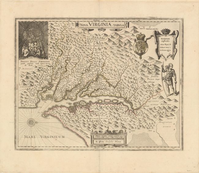
Auction 140, Lot 157
Subject: Colonial Mid-Atlantic
Hondius/Blaeu
Nova Virginiae Tabula, 1642
Size: 19 x 15 inches (48.3 x 38.1 cm)
Estimate: $2,750 - $3,500
One of the Most Important 17th Century Maps of the Chesapeake Bay
Sold for: $2,000
Closed on 5/23/2012
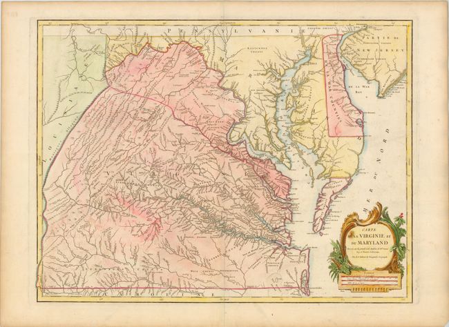
Auction 140, Lot 160
Subject: Mid-Atlantic United States
Robert de Vaugondy, Didier
Carte de la Virginie et du Maryland Dressee sur la Grande Carte Angloise de Mrs. Josue Fry et Pierre Jefferson…, 1793
Size: 25.5 x 19.3 inches (64.8 x 49 cm)
Estimate: $3,000 - $3,500
An Essential Map of Virginia and Maryland
Sold for: $2,100
Closed on 5/23/2012
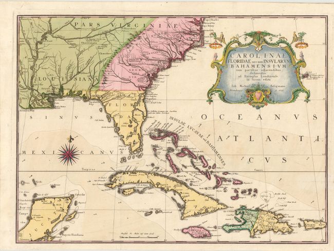
Auction 140, Lot 170
Subject: Colonial Southeast & Bahamas
Seligmann, Johann Michael
Carolinae Floridae nec non Insularum Bahamensium…, 1755
Size: 23 x 16.8 inches (58.4 x 42.7 cm)
Estimate: $5,500 - $6,500
Very Scarce and Important Map of the Southeastern United States
Unsold
Closed on 5/23/2012
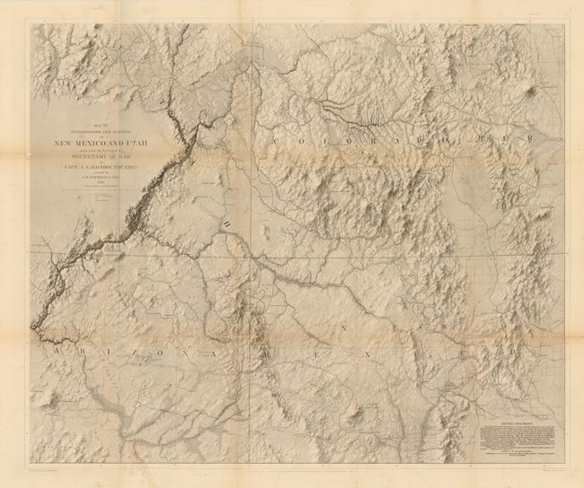
Auction 140, Lot 206
Subject: Southwestern United States
Macomb, J. N. (Col.)
Report of the Exploring Expedition from Santa Fe, New Mexico, to the Junction of the Green Rivers of the Great Colorado of the West, in 1859…, 1876
Size: 9.5 x 12 inches (24.1 x 30.5 cm)
Estimate: $1,500 - $2,000
Sold for: $950
Closed on 5/23/2012
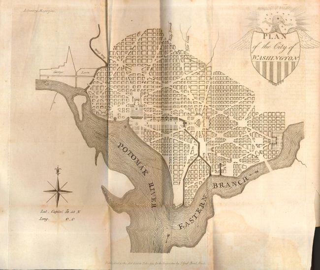
Auction 140, Lot 225
Subject: Washington, D.C.
Good, J.
Plan of the City of Washington, 1793
Size: 10.5 x 9.5 inches (26.7 x 24.1 cm)
Estimate: $2,500 - $3,250
Early British Version of the Thackara & Vallance DC Map
Sold for: $3,000
Closed on 5/23/2012
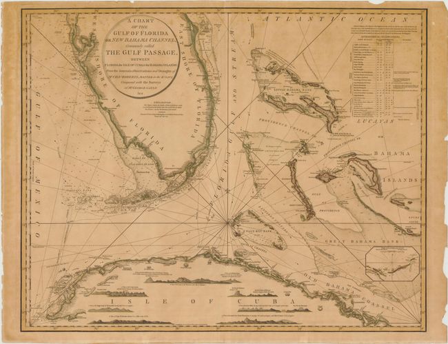
Auction 140, Lot 232
Subject: Southern Florida, Bahamas, Cuba
Faden, William
A Chart of the Gulf of Florida or New Bahama Channel, Commonly Called the Gulf Passage…, 1794
Size: 29 x 23 inches (73.7 x 58.4 cm)
Estimate: $6,000 - $9,000
A Magnificent and Rare Chart of Southern Florida, the Bahamas and Cuba
Sold for: $4,500
Closed on 5/23/2012
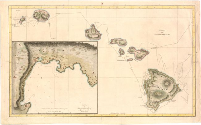
Auction 140, Lot 237
Subject: Hawaii
Cook, James (Capt.)
Chart of the Sandwich Islands, 1785
Size: 18.3 x 11 inches (46.5 x 27.9 cm)
Estimate: $800 - $1,000
The First Printed Map of Hawaii
Sold for: $700
Closed on 5/23/2012
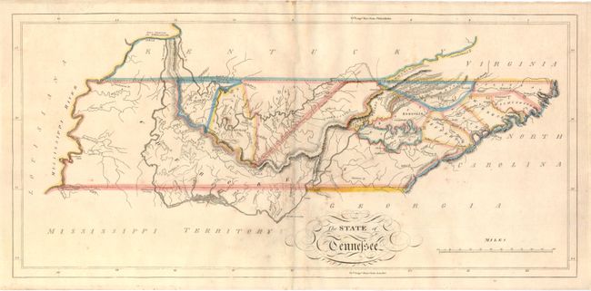
Auction 140, Lot 251
Subject: Tennessee
Carey, Mathew
The State of Tennessee, 1814
Size: 20.8 x 9.8 inches (52.8 x 24.9 cm)
Estimate: $900 - $1,100
Carey's Early Map of Tennessee
Sold for: $650
Closed on 5/23/2012
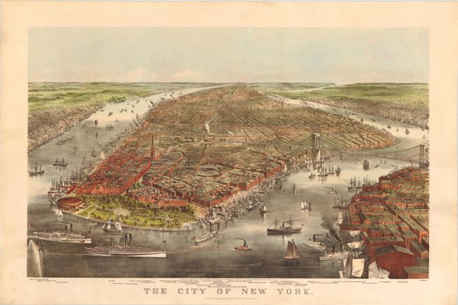
Auction 140, Lot 285
Subject: New York City, New York
Currier & Ives
The City of New York, 1870
Size: 32.8 x 22 inches (83.3 x 55.9 cm)
Estimate: $7,000 - $8,500
Fabulous View of the Brooklyn Bridge Prior to its Completion
Sold for: $4,750
Closed on 5/23/2012
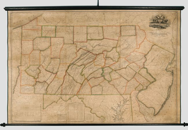
Auction 140, Lot 300
Subject: Pennsylvania
Melish, John
Map of Pennsylvania, Constructed from the County Surveys Authorized by the State; and other Original Documents...Corrected & Improved to 1826, 1826
Size: 73.5 x 42.5 inches (186.7 x 108 cm)
Estimate: $16,000 - $20,000
Melish's Greatest Published Work
Unsold
Closed on 5/23/2012
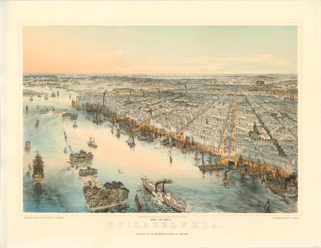
Auction 140, Lot 302
Subject: Philadelphia, Pennsylvania
Bachmann, John
Birds Eye View of Philadelphia, 1850
Size: 27.8 x 21 inches (70.6 x 53.3 cm)
Estimate: $3,750 - $4,500
Stunning View of Philadelphia by John Bachmann
Sold for: $2,750
Closed on 5/23/2012
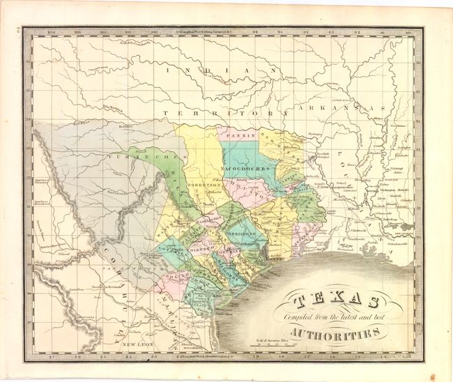
Auction 140, Lot 306
Subject: Texas
Greenleaf, Jeremiah
Texas Compiled from the Latest and Best Authorities, 1842
Size: 13 x 10.8 inches (33 x 27.4 cm)
Estimate: $2,000 - $2,500
Sold for: $1,900
Closed on 5/23/2012
17 lots