Subject: Tennessee
Period: 1814 (circa)
Publication: General Atlas…
Color: Hand Color
Size:
20.8 x 9.8 inches
52.8 x 24.9 cm
Mathew Carey was a seminal figure in early American publishing; establishing the first publishing firm to specialize in cartography and issuing the first atlas devoted exclusively to American maps. He set up an elaborate cottage system of craftsmen for compiling, engraving, printing, and coloring maps. This practice was emulated by later American cartographic publishers such as John Melish and Henry S. Tanner. The American Atlas concept was also adopted by other publishers in both the United States and Europe.
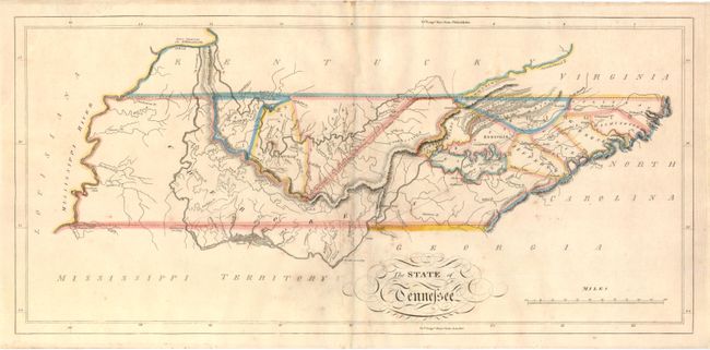
This fine map of Tennessee shows the state at an early point in its development with only twelve organized counties in the Mero and Washington Districts. The majority of the state is shown to be Cherokee tribal territory. The map depicts a few settlements, forts, trails, and roads, two of which venture out into Cherokee country toward the Tennessee River. This map lacks the engraved "22" plate mark above the neatline, and could possibly represent an unrecorded first state of the map which first appeared in Carey's General Atlas in 1814.
References:
Condition: B+
Good impression and original outline color with light toning centerfold and scattered foxing.