Showing Featured Lots(remove filter)
Filtered by Category:North America(Show All Categories)
Showing results for:Auction 190
Catalog Archive
4 lots
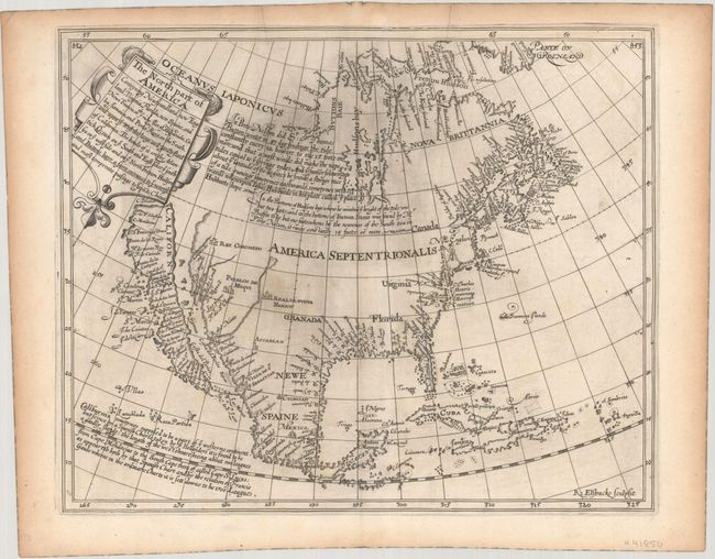
Auction 190, Lot 69
Subject: Colonial North America
Briggs, Henry
The North Part of America Conteyning Newfoundland, New England, Virginia, Florida, New Spaine, and Nova Francia..., 1625
Size: 13.8 x 11.2 inches (35.1 x 28.4 cm)
Estimate: $16,000 - $19,000
First English Map to Show California as an Island
Sold for: $11,500
Closed on 11/16/2022
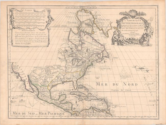
Auction 190, Lot 70
Subject: Colonial North America
Delisle, Guillaume
L'Amerique Septentrionale. Dressee sur les Observations de Mrs. de l'Academie Royale des Sciences. & Quelques Autres, & sur les Memoires les Plus Recens, 1700
Size: 23.6 x 17.9 inches (59.9 x 45.5 cm)
Estimate: $1,900 - $2,200
Delisle's Foundation Map of North America
Sold for: $1,200
Closed on 11/16/2022
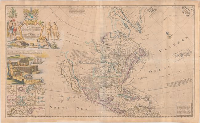
Auction 190, Lot 71
Subject: Colonial North America
Moll, Herman
To the Right Honourable John Lord Sommers Baron of Evesham ... This Map of North America According to ye Newest and Most Exact Observations..., 1730
Size: 38 x 22.7 inches (96.5 x 57.7 cm)
Estimate: $4,000 - $4,750
Moll's Famous "Codfish Map" of North America
Sold for: $3,750
Closed on 11/16/2022
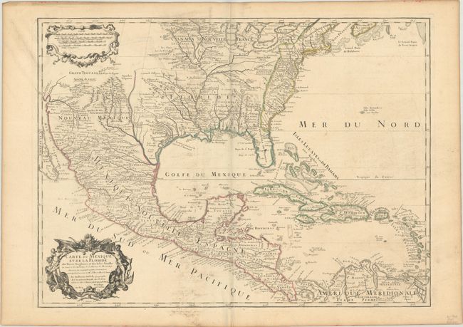
Auction 190, Lot 82
Subject: Colonial Eastern North America
Delisle, Guillaume
Carte du Mexique et de la Floride des Terres Angloises et des Isles Antilles du Cours et des Environs de la Riviere de Mississipi..., 1703
Size: 25.4 x 18.7 inches (64.5 x 47.5 cm)
Estimate: $1,800 - $2,100
Landmark in American Cartography - First Printed Map to Accurately Depict the Mouth of the Mississippi River
Sold for: $1,100
Closed on 11/16/2022
4 lots