Subject: Cartographic Miscellany
Period: 1855 (dated)
Publication: Atlas of the World
Color: Printed Color
Size:
23.5 x 16.2 inches
59.7 x 41.1 cm
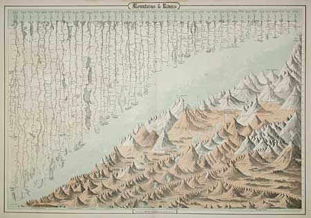
This great double-page chart, showing the major rivers and mountains of the world, was first issued by J.H. Colton in 1855 and here issued by Johnson and Browning in 1860 or 1861. The map is divided diagonally in an interesting composition. In the upper portion scores of rivers are named and drawn to indicate their relative lengths. The lower half of the sheet features stylized renderings of the mountains organized by continent and drawn to indicate their relative heights. Volcanoes are shown erupting and major cities are shown at their respective elevations.
References:
Condition: B
Minor toning and marginal tears.