Subject: Russia
Period: 1775 (circa)
Publication:
Color: Hand Color
Size:
20 x 10.5 inches
50.8 x 26.7 cm
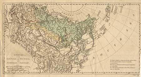
Attractive map of Russia in Asia including a good deal of China spanning from Sweden to a very sketchy coastline of Alaska and Canada. Names Mt. St. Elias and locates some discoveries of Bering, Tschirikow, de Fonte, and de Fuca. Extends to show the Black and Caspian Seas, the Gobi Desert, the Great Wall and Japan. An interesting color chart indicates that the area colored green is "barren Ground, which is not proper for Agriculture"; the yellow indicates "the Lands not cultivated, and which are proper for Agriculture"; while the red shows "cultivated Lands, which in the northern Parts yield but poor Crops".
References:
Condition: B
Nice dark impression on a full sheet of fine hand laid paper. Light coloring. Trimmed at binding side with a 3" section of neatline missing.